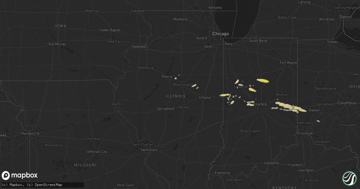
Hail Map in Illinois on May 30, 2019
Get this storm
May 30 map
$229
one time, instant access
Download today. No call, no setup
Keep the $229
Bought the map and want the full workflow? Apply the entire $229 to a subscription within 7 days. None of it is wasted.
Every map, not just this one
This buys you this map. Subscription and you get every map we run, in the markets you choose from a few cities to whole states to nationwide. Plus real-time alerts the moment a storm fires.
Contact data
Name, contact info, occupancy, even credit band for addresses in the footprint. You go from where it hit to who to call.
Become the source they trust
Unlimited branding weather history reports on demand. You already have the documented answer ready for the property owner, and you are the one who showed up with it.
Property data and RoofTrace estimates
Pull up any address you have got, its value and the exact code rules for that jurisdiction, straight from One Click Code. Then RoofTrace estimates the squares, pitch, and roof value, priced the way you price.
Storm reports in Illinois
Illinois
| Date | Description |
|---|---|
| 05/30/20196:07 PM CDT | Time estimated. Relayed by wcia-tv. |
| 05/30/201912:53 AM CDT | At 553 PM CDT, a severe thunderstorm was located near Saybrook, or 13 miles west of Gibson City, moving east at 20 mph. HAZARD...60 mph wind gusts and quarter size hail. SOURCE...Radar indicated. IMPACT...Hail damage to vehicles is expected. Expect wind damage to roofs, siding, and trees. Locations impacted include... Saybrook, Bellflower, Arrowsmith, Ellsworth and Moraine View State Park. |
| 05/30/201912:42 AM CDT | At 541 PM CDT, a severe thunderstorm was located near Secor, or 11 miles east of Eureka, moving northeast at 15 mph. HAZARD...Quarter size hail. SOURCE...Radar indicated. IMPACT...Damage to vehicles is expected. Locations impacted include... El Paso, Minonk, Secor, Benson and Panola. This includes Interstate 39 between mile markers 15 and 27. |
All States Impacted by Hail Map on May 30, 2019
Cities Impacted by Hail Map on May 30, 2019
- Newman Lake, WA
- Fredericksburg, TX
- Llano, TX
- Coleman, TX
- Burkett, TX
- Del Rio, TX
- Rocksprings, TX
- Hillsboro, IN
- Kingman, IN
- Bloomingdale, IN
- Pantego, NC
- Roper, NC
- Grifton, NC
- Kinston, NC
- Dover, NC
- Hallettsville, TX
- West Lafayette, IN
- Rapidan, VA
- Unionville, VA
- Orange, VA
- Whitestown, IN
- Mason, TX
- Fort Stockton, TX
- Red Bluff, CA
- Covington, IN
- Mountain Home, TX
- Ijamsville, MD
- West Friendship, MD
- Damascus, MD
- Cooksville, MD
- Adamstown, MD
- Monrovia, MD
- Frederick, MD
- Jefferson, MD
- Buckeystown, MD
- Mount Airy, MD
- Woodbine, MD
- Clarksburg, MD
- Glenwood, MD
- Leakey, TX
- Hunt, TX
- Stonewall, TX
- Sonora, TX
- Eldorado, TX
- Greensboro, MD
- Coyanosa, TX
- Chico, CA
- Corning, CA
- Lebanon, IN
- Comstock, TX
- New Paris, OH
- Lewisville, IN
- Hagerstown, IN
- Markleville, IN
- Cambridge City, IN
- Boston, IN
- Centerville, IN
- New Lebanon, OH
- Lewisburg, OH
- Middletown, IN
- Shirley, IN
- Camden, OH
- Richmond, IN
- Milton, IN
- Falmouth, IN
- Straughn, IN
- New Castle, IN
- West Alexandria, OH
- Eaton, OH
- Brownsville, IN
- Liberty, IN
- Connersville, IN
- Farmersville, OH
- Greens Fork, IN
- Quemado, TX
- Clearlake, CA
- Lower Lake, CA
- Menard, TX
- Westpoint, IN
- Lafayette, IN
- Wingate, IN
- Uvalde, TX
- Biggs, CA
- Oroville, CA
- Gridley, CA
- Johnson City, TX
- Hye, TX
- Aroda, VA
- Somerset, VA
- Ruckersville, VA
- Fredericksburg, VA
- Spotsylvania, VA
- Rochelle, VA
- Barboursville, VA
- Rhoadesville, VA
- Locust Grove, VA
- Forbestown, CA
- Strawberry Valley, CA
- Bristow, VA
- Fairfax, VA
- Catharpin, VA
- Fairfax Station, VA
- Gainesville, VA
- Clifton, VA
- Broad Run, VA
- Haymarket, VA
- Centreville, VA
- The Plains, VA
- Manassas, VA
- Brackettville, TX
- Goodfield, IL
- Eureka, IL
- Congerville, IL
- Deer Creek, IL
- Sweetwater, TX
- Nolan, TX
- Merkel, TX
- Dryden, TX
- Ozona, TX
- Gonzales, TX
- Jamestown, IN
- Faison, NC
- Mount Olive, NC
- Warsaw, NC
- Roscoe, TX
- Crystal City, TX
- Willows, CA
- Orland, CA
- Glenn, CA
- London, TX
- Berry Creek, CA
- Sprague, WA
- Mulberry, IN
- Frankfort, IN
- Michigantown, IN
- Bath, NC
- Washington, NC
- Pinetown, NC
- Chocowinity, NC
- Big Wells, TX
- Asherton, TX
- Ingram, TX
- Challenge, CA
- Snyder, TX
- Colville, WA
- Arnold, MD
- Gibson Island, MD
- Reva, VA
- Vanceboro, NC
- Ayden, NC
- Attica, IN
- Danville, IL
- Williamsport, IN
- Bismarck, IL
- State Line, IN
- Veedersburg, IN
- Kokomo, IN
- Converse, IN
- Miami, IN
- Greentown, IN
- Bunker Hill, IN
- Amboy, IN
- Galveston, IN
- Walton, IN
- Whitleyville, TN
- Moss, TN
- Willow City, TX
- Sheffield, TX
- Iraan, TX
- Cost, TX
- Laredo, TX
- Midland, TX
- Crawfordsville, IN
- Lizton, IN
- Brownsburg, IN
- Pittsboro, IN
- North Salem, IN
- Forest Ranch, CA
- Magalia, CA
- Paradise, CA
- Trenton, NC
- Cutler, IN
- Rossville, IN
- Radiant, VA
- Pioche, NV
- Secor, IL
- Marshall, IN
- Batesville, TX
- Hamilton City, CA
- Columbia, NC
- Milford, DE
- Charlottesville, IN
- Knightstown, IN
- Greenfield, IN
- Tuscola, TX
- La Pryor, TX
- Cuero, TX
- Battle Ground, IN
- Camptonville, CA
- Alpine, TX
- Northport, WA
- McCamey, TX
- Brownwood, TX
- Polson, MT
- Celina, TN
- Hamlin, TX
- Arrowsmith, IL
- Saybrook, IL
- Grandfalls, TX
- Pecos, TX
- Fairmount, IN
- Jonesboro, IN
- Hartford City, IN
- Gas City, IN
- Upland, IN
- Dexter, NM
- Hagerman, NM
- Weimar, TX
- La Grange, NC
- Hookerton, NC
- Cove City, NC
- Seven Springs, NC
- Grimesland, NC
- Deep Run, NC
- Jenkins, KY
- Queen Anne, MD
- Ridgely, MD
- Harrington, DE
- Felton, DE
- Chattaroy, WA
- Roseboro, NC
- Salemburg, NC
- Autryville, NC
- Republic, WA
- Greenwood, DE
- Lincoln, DE
- Goldsboro, MD
- Milton, DE
- Centreville, MD
- Houston, DE
- Eagle Pass, TX
- Yoakum, TX
- Shiner, TX
- New Ross, IN
- Davenport, WA
- House, NM
- Cotulla, TX
- Elk, WA
- Clinton, NC
- Imperial, TX
- Middletown, MD
- Gaithersburg, MD
- Brookeville, MD
- Braddock Heights, MD
- Glenelg, MD
- Plymouth, NC
- Novice, TX
- Swayzee, IN
- Cheney, WA
- Ernul, NC
- Valley, WA
- Moscow, ID
- Midkiff, TX
- Rushville, IN
- Oregonia, OH
- Clarksville, OH
- Calypso, NC
- Brookston, IN
- Kettle Falls, WA
- El Campo, TX
- Winterville, NC
- Greenville, NC
- Louise, TX
- Marion, IN
- Otterbein, IN
- Medina, TX
- Mitchells, VA
- Culpeper, VA
- Columbus, TX
- Gifford, WA
- Fort Hancock, TX
- Waynesville, OH
- Nixon, TX
- Rosharon, TX
- Belhaven, NC
- Greenville, OH
- Junction, TX
- Bellflower, IL
- Foosland, IL
- Kerrville, TX
- Winters, TX
- Manvel, TX
- Hext, TX
- Marfa, TX
- Marathon, TX
- Fort Davis, TX
- Valentine, TX
- New Market, MD


