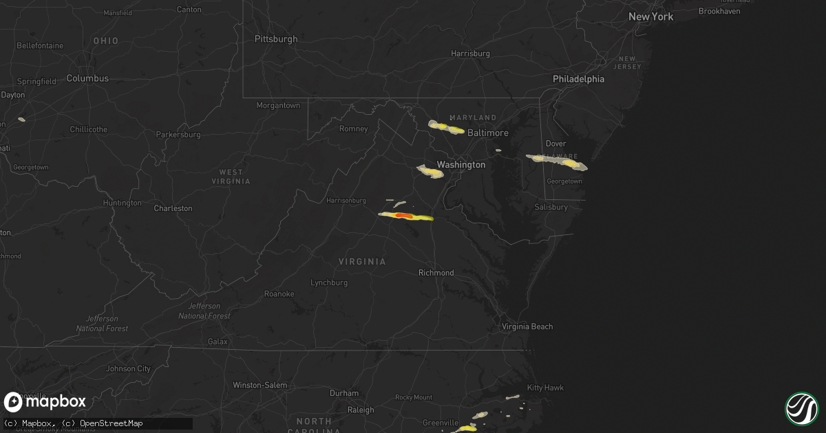
Hail Map on May 30, 2019
Get this storm
May 30 map
$229
one time, instant access
Download today. No call, no setup
Keep the $229
Bought the map and want the full workflow? Apply the entire $229 to a subscription within 7 days. None of it is wasted.
Every map, not just this one
This buys you this map. Subscription and you get every map we run, in the markets you choose from a few cities to whole states to nationwide. Plus real-time alerts the moment a storm fires.
Contact data
Name, contact info, occupancy, even credit band for addresses in the footprint. You go from where it hit to who to call.
Become the source they trust
Unlimited branding weather history reports on demand. You already have the documented answer ready for the property owner, and you are the one who showed up with it.
Property data and RoofTrace estimates
Pull up any address you have got, its value and the exact code rules for that jurisdiction, straight from One Click Code. Then RoofTrace estimates the squares, pitch, and roof value, priced the way you price.
States Impacted by Hail Map on May 30, 2019
Storm reports
Maryland
| Date | Description |
|---|---|
| 05/30/20194:06 PM CDT | Trees down just east of cambridge. |
| 05/30/20194:05 PM CDT | Wires down in preston. Time estimated by radar. |
| 05/30/20193:54 PM CDT | A local report indicates 58 MPH wind near OXFORD |
| 05/30/20193:54 PM CDT | A local report indicates 58 MPH wind near 14 ENE DARES BEACH |
| 05/30/20193:54 PM CDT | A local report indicates 58 MPH wind near 19 E CHESAPEAKE BEACH |
| 05/30/20193:45 PM CDT | Trees and wired down in goldsboro. Time estimated by radar. |
| 05/30/20193:40 PM CDT | Trees and wires down in greensboro. Time estimated by radar. |
| 05/30/20193:35 PM CDT | Trees and wired down in ridgely. Time based on radar. |
| 05/30/20193:35 PM CDT | Straight-line winds estimated between 60 and 70 mph uprooted or snapped large limbs from 15 trees. Delayed report from thursday afternoon. |
| 05/30/20193:30 PM CDT | Reports of trees down and power outages near the queen anne area along the queen annes and talbot county border. Time estimated from radar. |
| 05/30/20192:53 PM CDT | Telephone phone poles down on key highway near mccomas street. |
| 05/30/20192:51 PM CDT | Tree down on a house in the 3200 block of maygreen avenue. |
| 05/30/20192:48 PM CDT | Several trees down in the area |
| 05/30/20192:37 PM CDT | Free-standing traffic light down at intersection of martin luther king blvd and pennsylvania ave per baltimore sun image. |
| 05/30/20192:37 PM CDT | Tree down on house on riverside circle. Multiple trees down in the area. |
| 05/30/20192:35 PM CDT | Traffic pole down near the intersection of martin luthor king jr. Blvd and pennsylvania ave. |
| 05/30/20192:26 PM CDT | Roof damage to a shop in the 400 block of route 32. |
| 05/30/20192:26 PM CDT | Roof damage to a shop in the 400 block of route 32. |
| 05/30/20192:22 PM CDT | Tornado confirmed by klwx wsr-88d debris ball signature coincident with faa tdwr bwi base velocity... Coupled with credible video from the area. Nws storm survey will b |
| 05/30/20192:20 PM CDT | Ef1 tornado with estimated peak winds of 100 mph. Path length 4.5 miles... Max width 100 yards. Time on ground from 320-327 pm edt. Storm motion was ese 40 mph. |
| 05/30/20192:17 PM CDT | A local report indicates 1.00 inch wind near LISBON |
| 05/30/20192:06 PM CDT | Tree down on the 29010 block of ridge road. |
| 05/30/20192:06 PM CDT | Several reports of trees and wires down. |
| 05/30/20192:06 PM CDT | Tree down on the 28600 block of kemptown road. |
| 05/30/20191:54 PM CDT | A local report indicates 71 MPH wind near 2 W NEW MARKET |
| 05/30/20191:51 PM CDT | Tree down on the 4600 block of araby church road. |
| 05/30/20191:48 PM CDT | Ef0 tornado with estimated peak winds of 85 mph. Path length 6.5 mile... Discontinuous damage path... Max width 75 yards. Time on ground from 248-259 pm edt. Storm moti |
| 05/29/201911:33 PM CDT | At 432 PM EDT, a severe thunderstorm was located near Breezy Point, moving east at 45 mph. HAZARD...60 mph wind gusts and penny size hail. SOURCE...Radar indicated. IMPACT...Expect damage to trees and powerlines. This severe thunderstorm will be near, Cambridge and University Of Maryland Center For Environmental Studies around 455 PM EDT. Secretary around 505 PM EDT. Hurlock around 510 PM EDT. Vienna around 515 PM EDT.Other locations impacted by this severe thunderstorm include Madison,Brookview, Eldorado, Woolford, Hudson, East New Market, Church Creek,Bucktown, Linkwood and Lloyds. |
| 05/29/201911:03 PM CDT | At 403 PM EDT, a severe thunderstorm was located over Aquia Creek, moving east at 40 mph. HAZARD...60 mph wind gusts. SOURCE...Radar indicated. IMPACT...Damaging winds will cause some trees and large branches to fall. This could injure those outdoors, as well as damage homes and vehicles. Roadways may become blocked by downed trees. Localized power outages are possible. Unsecured light objects may become projectiles. Locations impacted include... Stafford, La Plata, King George, Woodbridge, Dahlgren, Quantico, Fairview Beach, Potomac Creek, Aquia Creek, Port Tobacco River, Popes Creek, Triangle, Dumfries, Wicomico, Cherry Hill, Bryans Road, Falmouth, Mason Neck, Potomac Heights and Pomfret. |
| 05/29/201910:53 PM CDT | At 352 PM EDT, a severe thunderstorm was located near Gibson Island, moving east at 35 mph. HAZARD...60 mph wind gusts and quarter size hail. SOURCE...Radar indicated. IMPACT...Minor damage to vehicles is possible. Wind damage to roofs, siding, trees, and power lines is possible. Locations impacted include... Centerville, Chestertown, Centreville, Rock Hall, Church Hill, Millington, Sudlersville, Queen Anne, Old Town, Grasonville, Starr, Morgnec, Crumpton, Skipton, Langford, Matthews, Overton, Starkey Corner, Wye Mills and Cordova. |
| 05/29/201910:42 PM CDT | At 342 PM EDT, a severe thunderstorm was located over Fort Hunt, moving east at 30 mph. HAZARD...70 mph wind gusts and quarter size hail. SOURCE...Radar indicated. IMPACT...Damaging winds will cause some trees and large branches to fall. This could injure those outdoors, as well as damage homes and vehicles. Roadways may become blocked by downed trees. Localized power outages are possible. Unsecured light objects may become projectiles. Locations impacted include... Waldorf, Clinton, Springfield, Fort Washington, Fort Hunt, Groveton, Huntington, Fort Belvoir, Lincolnia, Lorton, Franconia, Oxon Hill, Hybla Valley, Newington, Rosaryville, Friendly, Marlton, Dunkirk, Saint Charles and Mount Vernon. |
| 05/29/201910:33 PM CDT | At 332 PM EDT, a severe thunderstorm was located near Ellicott City, or near Columbia, moving east at 45 mph. HAZARD...70 mph wind gusts. SOURCE...Radar indicated. IMPACT...Damaging winds will cause some trees and large branches to fall. This could injure those outdoors, as well as damage homes and vehicles. Roadways may become blocked by downed trees. Localized power outages are possible. Unsecured light objects may become projectiles. Locations impacted include... Baltimore, Columbia, Severn, Pikesville, Middle River, Elkridge, Riviera Beach, Baltimore-Washington Airport, Gibson Island, Bodkin Point, Sillery Bay, Millers Island, North Point State Park, Pinehurst, Back River, Sparrows Point, Glen Burnie, Ellicott City, Dundalk and Towson. |
| 05/29/20199:53 PM CDT | At 253 PM EDT, a severe thunderstorm was located over Linganore-Bartonsville, or near Harry Grove Stadium, moving east at 45 mph. HAZARD...Ping pong ball size hail and 60 mph wind gusts. SOURCE...Radar indicated. IMPACT...Damaging winds will cause some trees and large branches to fall. This could injure those outdoors, as well as damage homes and vehicles. Roadways may become blocked by downed trees. Localized power outages are possible. Unsecured light objects may become projectiles. Locations impacted include... Columbia, Frederick, Pikesville, Damascus, Harry Grove Stadium, Ellicott City, Catonsville, Woodlawn, Randallstown, Owings Mills, Eldersburg, Milford Mill, Reisterstown, Lochearn, Ballenger Creek, Mount Airy, Walkersville, Sykesville, Oakland and New Market. |
| 05/29/20199:32 PM CDT | At 232 PM EDT, a severe thunderstorm was located over The Plains, or 11 miles north of Warrenton, moving east at 40 mph. HAZARD...60 mph wind gusts and quarter size hail. SOURCE...Radar indicated. IMPACT...Damaging winds will cause some trees and large branches to fall. This could injure those outdoors, as well as damage homes and vehicles. Roadways may become blocked by downed trees. Localized power outages are possible. Unsecured light objects may become projectiles. Locations impacted include... Centreville, Reston, Annandale, Springfield, South Riding, Herndon, Fairfax, Vienna, Brambleton, Mantua, Pimmit Hills, Dulles International Airport, Potomac, Burke, Linton Hall, Oakton, Sterling, Chantilly, Tysons Corner and Lorton. |
Pennsylvania
| Date | Description |
|---|---|
| 05/30/20193:55 PM CDT | Downed trees and powerlines in albrightsville. |
| 05/30/20192:43 PM CDT | Delayed report. Downed tree on summit road near swiftwater forcing its closure. Time estimated from radar. |
| 05/30/201912:20 AM CDT | At 519 PM EDT, severe thunderstorms were located along a line extending from Long Valley to Milford, moving east at 25 mph. HAZARD...60 mph wind gusts and penny size hail. SOURCE...Radar indicated. IMPACT...Damage to roofs, siding, trees, and power lines is possible. Locations impacted include... Morristown, Somerville, Bridgewater, Dover, Madison, Middlesex, Florham Park, East Hanover, Bound Brook, Manville, Hackettstown, Chatham, Wharton, Rockaway, Morris Plains, Mount Arlington, Mendham, Flemington, Mountain Lakes and High Bridge. |
| 05/29/201911:48 PM CDT | At 448 PM EDT, a severe thunderstorm was located near Riegelsville, or near Easton, moving east at 30 mph. HAZARD...60 mph wind gusts and nickel size hail. SOURCE...Radar indicated. IMPACT...Damage to roofs, siding, trees, and power lines is possible. Locations impacted include... Easton, Bethlehem, Hellertown, Flemington, Clinton, Alpha, Ferndale, Frenchtown, Lebanon, Milford, Bloomsbury, Riegelsville, Glendon, Revere, Springtown, Erwinna, Annandale, Old Orchard, Sand Brook and White House Station. |
| 05/29/201911:40 PM CDT | At 440 PM EDT, a severe thunderstorm was located over Harmony, or near Easton, moving east at 20 mph. HAZARD...60 mph wind gusts and nickel size hail. SOURCE...Radar indicated. IMPACT...Damage to roofs, siding, trees, and power lines is possible. Locations impacted include... Easton, Forks, Hackettstown, Wilson, Washington, Nazareth, Bangor, High Bridge, Wind Gap, Clinton, Belvidere, Harmony, Oxford, Alpha, Hope, Glen Gardner, Belfast, Hampton, Lebanon and West Easton. |
| 05/29/201911:36 PM CDT | At 435 PM EDT, a severe thunderstorm was located over Florence-Roebling, or near Trenton, moving east at 20 mph. HAZARD...60 mph wind gusts and quarter size hail. SOURCE...Radar indicated. IMPACT...Minor damage to vehicles is possible. Wind damage to roofs, siding, trees, and power lines is possible. Locations impacted include... Trenton, Florence, Burlington, Bristol, Bordentown, Tullytown, Allentown, Crosswicks, White Horse, Florence-Roebling, Imlaystown, Cream Ridge, Levittown, Columbus, Georgetown, Mercerville-Hamilton Square, Fieldsboro, New Egypt, Yardville-Groveville and McGuire AFB. |
New Mexico
| Date | Description |
|---|---|
| 05/30/20196:13 PM CDT | Ktcc asos. |
| 05/30/20193:29 PM CDT | A local report indicates 59 MPH wind near 9 ESE MESITA |
| 05/30/20192:42 PM CDT | Landspout tornado. |
| 05/29/20197:47 PM CDT | Roof ripped off of dairy barn and windows blown out of house across street near ojibwa rd. And highway 285... Time approx. |
New Jersey
| Date | Description |
|---|---|
| 05/30/20194:10 PM CDT | Some reports of a few trees down in allamuchy twp. Time estimated from radar. |
| 05/30/201912:55 AM CDT | At 554 PM EDT, severe thunderstorms were located along a line extending from Millington to near Flagtown, moving east at 35 mph. HAZARD...60 mph wind gusts and penny size hail. SOURCE...Radar indicated. IMPACT...Damage to roofs, siding, trees, and power lines is possible. Locations impacted include... New Brunswick, Perth Amboy, Somerville, Somerset, Edison, Old Bridge, East Brunswick, Bridgewater, Sayreville, North Brunswick, Carteret, Middlesex, Bound Brook, Manville, Matawan, Millstone, Flagtown, Colonia, Brownville and Belle Mead. |
| 05/30/201912:32 AM CDT | At 531 PM EDT, a severe thunderstorm was located 10 miles east of Big Stone Beach, or 13 miles west of Cape May, moving east at 40 mph. HAZARD...60 mph wind gusts and penny size hail. SOURCE...Radar indicated. IMPACT...Damage to roofs, siding, trees, and power lines is possible. Locations impacted include... Cape May, North Wildwood, Wildwood Crest, West Cape May, Stone Harbor, Cape May Court House, Diamond Beach, Green Creek, Rio Grande, North Cape May, Villas, West Wildwood, Erma and Whitesboro-Burleigh. |
District of Columbia
| Date | Description |
|---|---|
| 05/29/201910:10 PM CDT | At 310 PM EDT, a severe thunderstorm was located over Centreville, moving east at 30 mph. HAZARD...Ping pong ball size hail and 60 mph wind gusts. SOURCE...Radar indicated. IMPACT...Damaging winds will cause some trees and large branches to fall. This could injure those outdoors, as well as damage homes and vehicles. Roadways may become blocked by downed trees. Localized power outages are possible. Unsecured light objects may become projectiles. Locations impacted include... Arlington, Alexandria, Centreville, Waldorf, Reston, Annandale, Clinton, Springfield, South Riding, Fort Washington, Fairfax, Fort Hunt, Vienna, Groveton, Falls Church, Huntington, Coral Hills, Mantua, Fort Belvoir and Pimmit Hills. |
Virginia
| Date | Description |
|---|---|
| 05/30/20196:39 PM CDT | Trees were down blocking two lanes on interstate 95 around mile marker 124. |
| 05/30/20196:10 PM CDT | Dozens of trees down on the edge of a recently logged forest near price road and lake country lane. All trees oriented generally west to east... Indicating straight-lin |
| 05/30/20196:09 PM CDT | A local report indicates 1.00 inch wind near 3 SSE VERDIERSVILLE |
| 05/30/20195:54 PM CDT | A local report indicates 1.75 inch wind near 1 SW NASONS |
| 05/30/20195:52 PM CDT | Tree down on spotters property in orange. |
| 05/30/20195:50 PM CDT | A local report indicates 1.25 inch wind near 1 ENE ORANGE |
| 05/30/20195:50 PM CDT | Tree down on homewood drive and rapidan road. |
| 05/30/20195:39 PM CDT | Multiple reports of trees down along south blue ridge turnpike near uno. |
| 05/30/20195:14 PM CDT | Tree down near the intersection of spotswood trail and powell mountain road. |
| 05/30/20195:10 PM CDT | Multiple trees down in the price road with over 20 trees reported down. |
| 05/30/20195:03 PM CDT | Tree reported down on hawfield road. |
| 05/30/20194:48 PM CDT | Multiple trees down. Metal roofing peeled back on a house. Porch damaged. |
| 05/30/20194:35 PM CDT | Barn destroyed off of rt. 11 in mt. Crawford. |
| 05/30/20194:35 PM CDT | Multiple trees down near airport road and kiser road. |
| 05/30/20192:56 PM CDT | A local report indicates 63 MPH wind near 2 E WOODBRIDGE |
| 05/30/20192:53 PM CDT | Tree down on general drive and cooper street |
| 05/30/20192:48 PM CDT | Tree on house on the 14000 block of pratt street. |
| 05/30/20192:48 PM CDT | Tree down on the 1700 block of featherstone road. |
| 05/30/20192:48 PM CDT | Tree down on a house on the 15000 block of illinois road. |
| 05/30/20192:48 PM CDT | Tree down on wharf lane near olde port lane. |
| 05/30/20192:39 PM CDT | Tree down on pole road and carlwood road. |
| 05/30/20192:39 PM CDT | Tree down at lukens lane and old mill road. |
| 05/30/20192:36 PM CDT | Trees down near intersection of john j kingman road and gunston road. |
| 05/30/20192:36 PM CDT | A local report indicates 66 MPH wind near DAVISON ARMY AIRFLD |
| 05/30/20192:27 PM CDT | Tree down on glenister drive. |
| 05/30/20192:17 PM CDT | Trees down in multiple locations along clifton road. |
| 05/30/20192:10 PM CDT | Multiple trees down in the price road with over 20 trees reported down. |
| 05/30/20192:09 PM CDT | Tree down on 7800 block of wall street in manassas. |
| 05/30/20192:06 PM CDT | Wires down on old centreville road and compton road. |
| 05/30/20192:03 PM CDT | Tree reported down on hawfield road. |
| 05/30/20192:01 PM CDT | Tree down on powerlines near country club road and stoneybrook lane |
| 05/30/20191:58 PM CDT | Tree down near the intersection of groveton road and general longstreet line. |
| 05/30/20191:56 PM CDT | A local report indicates 71 MPH wind near GAINESVILLE |
| 05/30/20191:38 PM CDT | Tree down on to powerlines on the 6200 block of lee street. |
| 05/30/20191:37 PM CDT | Tree down on powerlines on the 4200 block of mosby street. |
| 05/30/20191:35 PM CDT | Tree down on powerlines on the 3500 block of milestone road. |
| 05/30/20196:41 AM CDT | At 1140 PM EDT, severe thunderstorms were located along a line extending from near Seaford to near Isle Of Wight to near Carrsville, moving east at 40 mph. HAZARD...60 mph wind gusts. SOURCE...Radar indicated. IMPACT...Expect damage to trees and powerlines. Severe thunderstorms will be near, Hampton, Langley AFB, Seaford and Tabb around 1145 PM EDT. Grand View around 1150 PM EDT. Suffolk, Crittenden and Driver around 1155 PM EDT. Downtown Suffolk, Churchland, Portsmouth and Western Branch around 1205 AM EDT. Old Dominion University, Downtown Norfolk, Downtown Portsmouth, Ghent and Norfolk NAS around 1210 AM EDT. Norfolk State University, Ocean View, Norview and Bowers Hill around 1215 AM EDT. Virginia Wesleyan University, Kempsville, Regent University, Norfolk, Chesapeake and Norfolk International around 1220 AM EDT. Deep Creek and Cradock around 1225 AM EDT.Other locations impacted by these severe thunderstorms include SouthNorfolk, Rudee Heights, Portlock, Longview, Huntersville, Oriana,Chuckatuck, Pungo, Bayside and Wilroy. |
| 05/30/20192:33 AM CDT | At 733 PM EDT, a severe thunderstorm was located over Davenport, moving east at 30 mph. HAZARD...60 mph wind gusts and quarter size hail. SOURCE...Radar indicated. IMPACT...Hail damage to vehicles is expected. Expect wind damage to roofs, siding, and trees. Locations impacted include... Davenport. |
| 05/30/20191:31 AM CDT | At 631 PM EDT, a severe thunderstorm was located near Madison, moving east at 35 mph. HAZARD...60 mph wind gusts and quarter size hail. SOURCE...Radar indicated. IMPACT...Damaging winds will cause some trees and large branches to fall. This could injure those outdoors, as well as damage homes and vehicles. Roadways may become blocked by downed trees. Localized power outages are possible. Unsecured light objects may become projectiles. Locations impacted include... Orange, Ruckersville, Eheart, Oakpark, Verdiersville, Everona, Montpelier Station, Newtown, Nasons, Madison Mills, Montford, Mitchells, Old Somerset, Unionville, Somerset, Locust Dale, Raccoon Ford, Rhoadesville, Rapidan and Madison Run. |
| 05/30/201912:54 AM CDT | At 554 PM EDT, a severe thunderstorm was located near Massanutten, or 11 miles southeast of Harrisonburg, moving east at 35 mph. HAZARD...Ping pong ball size hail and 60 mph wind gusts. SOURCE...Radar indicated. IMPACT...Damaging winds will cause some trees and large branches to fall. This could injure those outdoors, as well as damage homes and vehicles. Roadways may become blocked by downed trees. Localized power outages are possible. Unsecured light objects may become projectiles. Locations impacted include... Madison, Stanardsville, Elkton, Ruckersville, Quinque, Lydia, Haneytown, Newtown, Amicus, Shady Grove, Hood, Mcmullen, Boonesville, Pratts, Rochelle, Mission Home, Swift Run, Shelby, Dawsonville and Fletcher. |
| 05/30/201912:26 AM CDT | At 526 PM EDT, a severe thunderstorm was located near Bridgewater, or 10 miles southwest of Harrisonburg, moving east at 35 mph. HAZARD...60 mph wind gusts and quarter size hail. SOURCE...Radar indicated. IMPACT...Damaging winds will cause some trees and large branches to fall. This could injure those outdoors, as well as damage homes and vehicles. Roadways may become blocked by downed trees. Localized power outages are possible. Unsecured light objects may become projectiles. Locations impacted include... Harrisonburg, Bridgewater, Grottoes, Massanutten, Elkton, Weyers Cave, Dayton, Mount Sidney, Mount Crawford, Rocky Bar, Penn Laird, Port Republic, Pleasant Valley, Moscow, Montezuma, Mount Solon, Sangerville, Fort Defiance, Keezletown and Mcgaheysville. |
| 05/29/201911:19 PM CDT | At 419 PM EDT, severe thunderstorms were located along a line extending from near Dunkirk to near Nanjemoy Creek, moving east at 45 mph. HAZARD...60 mph wind gusts. SOURCE...Radar indicated. IMPACT...Damaging winds will cause some trees and large branches to fall. This could injure those outdoors, as well as damage homes and vehicles. Roadways may become blocked by downed trees. Localized power outages are possible. Unsecured light objects may become projectiles. Locations impacted include... Waldorf, Lexington Park, Chesapeake Ranch Estates, La Plata, Shady Side, Chesapeake Beach, Deale, Leonardtown, Dahlgren, Prince Frederick, Hallowing Point, Saint Leonard Creek, Sheridan Point, Calvert Cliffs, Port Tobacco River, Flag Harbor, Popes Creek, California, Golden Beach and Dunkirk. |
| 05/29/201911:05 PM CDT | Tree down on home. Time estimated from radar. |
| 05/29/201910:55 PM CDT | Tree down on w constance road. Time estimated from radar. |
| 05/29/201910:50 PM CDT | Trees downed onto power lines along hornsbyville rd. |
| 05/29/201910:15 PM CDT | Tree down causing damage to aluminum carport on runnymede road. |
| 05/29/20199:41 PM CDT | At 241 PM EDT, a severe thunderstorm was located 8 miles south of Front Royal, moving east at 35 mph. HAZARD...60 mph wind gusts and quarter size hail. SOURCE...Radar indicated. IMPACT...Damaging winds will cause some trees and large branches to fall. This could injure those outdoors, as well as damage homes and vehicles. Roadways may become blocked by downed trees. Localized power outages are possible. Unsecured light objects may become projectiles. Locations impacted include... Front Royal, Warrenton, The Plains, Linden, Hume, Marshall, Chester Gap, Opal, Flint Hill, Washington, Huntly, Hackleys Crossroads, Amissville, Cresthill, Karo, Turnbull, Glen Echo, Bentonville, Meadowville and Arco. |
| 05/29/20199:20 PM CDT | At 220 PM EDT, a severe thunderstorm was located near Shepherdstown, moving east at 25 mph. HAZARD...60 mph wind gusts. SOURCE...Radar indicated. IMPACT...Damaging winds will cause some trees and large branches to fall. This could injure those outdoors, as well as damage homes and vehicles. Roadways may become blocked by downed trees. Localized power outages are possible. Unsecured light objects may become projectiles. Locations impacted include... Frederick, Shepherdstown, Harry Grove Stadium, Ballenger Creek, Brunswick, Walkersville, Boonsboro, Braddock Heights, New Market, Harpers Ferry, Clover Hill, Discovery-Spring Garden, Linganore-Bartonsville, Adamstown, Jefferson, Myersville, Keedysville, Buckeystown, Libertytown and Sharpsburg. |
| 05/29/20197:10 PM CDT | A local report indicates 1.00 inch wind near 1 WSW PARKER |
Tennessee
| Date | Description |
|---|---|
| 05/30/20197:37 AM CDT | At 1236 PM CDT, a severe thunderstorm was located near Celina, moving northeast at 35 mph. HAZARD...60 mph wind gusts and quarter size hail. SOURCE...Radar indicated. IMPACT...Hail damage to vehicles is expected. Expect wind damage to roofs, siding, and trees. Locations impacted include... Celina, Moss and Dale Hollow Lake. |
West Virginia
| Date | Description |
|---|---|
| 05/29/201910:11 PM CDT | At 310 PM EDT, a severe thunderstorm was located near Man, or 7 miles east of Logan, moving east at 35 mph. HAZARD...60 mph wind gusts and quarter size hail. SOURCE...Radar indicated. IMPACT...Hail damage to vehicles is expected. Expect wind damage to roofs, siding, and trees. Locations impacted include... Amherstdale-Robinette, Bald Knob and Amherstdale-Robine. |
| 05/29/20198:45 PM CDT | At 144 PM EDT, a severe thunderstorm was located near Martinsburg, moving east at 35 mph. HAZARD...60 mph wind gusts and quarter size hail. SOURCE...Radar indicated. IMPACT...Damaging winds will cause some trees and large branches to fall. This could injure those outdoors, as well as damage homes and vehicles. Roadways may become blocked by downed trees. Localized power outages are possible. Unsecured light objects may become projectiles. Locations impacted include... Martinsburg, Shepherdstown, Boonsboro, Mount Lena, San Mar, Saint James, Berkeley, Keedysville, Falling Waters, Sharpsburg, Fairplay, Hedgesville, Rohrersville, Gapland, Antietam, Winebrenners Cross, Tomahawk, Johnsontown, Moler Crossroads and Jones Springs. |
Montana
| Date | Description |
|---|---|
| 05/30/20195:05 PM CDT | Shed damaged and displaced 10 yards by outflow. |
Indiana
| Date | Description |
|---|---|
| 05/30/20196:50 PM CDT | A local report indicates 1.00 inch wind near NEW CASTLE |
| 05/30/20194:22 PM CDT | House and tree damage. No further details at this time. |
| 05/30/20194:15 PM CDT | Grant county sheriff dept reports large tree snapped in half and utility pole damaged. |
| 05/30/20192:49 AM CDT | At 748 PM EDT, a severe thunderstorm was located over New Castle, or 12 miles northwest of Cambridge City, moving east at 30 mph. HAZARD...Quarter size hail. SOURCE...Radar indicated. IMPACT...Damage to vehicles is expected. Locations impacted include... New Castle, Straughn and Greensboro. This includes Interstate 70 between mile markers 122 and 133. |
| 05/30/20191:18 AM CDT | At 618 PM EDT, a severe thunderstorm was located 7 miles east of Frankfort, moving southeast at 25 mph. HAZARD...Quarter size hail. SOURCE...Radar indicated. IMPACT...Damage to vehicles is expected. Locations impacted include... Tipton, Sheridan, Michigantown and Kempton. |
| 05/29/201911:09 PM CDT | At 408 PM EDT, a severe thunderstorm was located 8 miles northwest of Swayzee, or 11 miles southeast of Grissom Afb, moving east at 25 mph. HAZARD...60 mph wind gusts and half dollar size hail. SOURCE...Radar indicated. IMPACT...Hail damage to vehicles is expected. Expect wind damage to roofs, siding, and trees. This severe thunderstorm will remain over mainly rural areas of northeastern Howard County. |
| 05/29/201911:04 PM CDT | At 404 PM EDT, a severe thunderstorm was located 8 miles southeast of Bunker Hill, or 10 miles southeast of Grissom Afb, moving east at 30 mph. HAZARD...60 mph wind gusts and half dollar size hail. SOURCE...Radar indicated. IMPACT...Hail damage to vehicles is expected. Expect wind damage to roofs, siding, and trees. Locations impacted include... Marion, Gas City, Fairmount, Jonesboro, Sweetser, Swayzee, Sims, Converse, Amboy, Home Corner, Michaelsville, Normal, Mier, Jalapa, Herbst, Santa Fe, Hanfield, Wawpecong, Hackleman and Radley. |
| 05/29/20197:15 PM CDT | Tree down on washington road. Time estimated from radar. |
North Carolina
| Date | Description |
|---|---|
| 05/30/20196:55 PM CDT | Trees and wires down in the area along with a light pole. |
| 05/30/20196:55 PM CDT | Cocorahs observer reported quarter size hail at 7:55 pm. |
| 05/30/20196:55 PM CDT | Quarter size hail in bath. |
| 05/30/20196:50 PM CDT | Quarter size hail and 50 mph winds east of washington. |
| 05/30/20196:45 PM CDT | 2 telephone poles snapped near the base... Large tree branches down. Picture sent to us by tideland electric. |
| 05/30/20196:25 PM CDT | Public reported damage in parkton... Nc area. Semi flipped on 71 near malloy rd. Several power lines and trees down in town. |
| 05/30/20196:25 PM CDT | Media shared photos of tree down on house in town of parkton. |
| 05/30/20196:17 PM CDT | Trees and power lines down in farmville. |
| 05/30/20195:45 PM CDT | Measured at kfbg asos. |
| 05/30/20195:29 PM CDT | Measured at kpob asos. |
| 05/30/20195:30 AM CDT | Edgewater ridge court. |
| 05/30/20194:14 AM CDT | At 912 PM EDT, a severe thunderstorm was located near Tuscarora, or 11 miles west of New Bern, moving southeast at 30 mph. This storm has a history of producing damaging winds and knocking down trees. HAZARD...70 mph wind gusts. SOURCE...Trained weather spotters. IMPACT...Expect considerable tree damage. Damage is likely to mobile homes, roofs, and outbuildings. Locations impacted include... New Bern, James City, Trent Woods, River Bend, Jasper, Tuscarora, Rhems, Olympia, Croatan, Riverdale, Catfish Lake, Neuse Forest, Fairfield Harbour, Coastal Carolina Regional Airport, Bridgeton, Cove City, Pollocksville and Trenton. |
| 05/30/20193:54 AM CDT | At 853 PM EDT, severe thunderstorms were located along a line extending from near Clinton to Fort Barnwell, moving east at 45 mph. HAZARD...60 mph wind gusts. SOURCE...Radar indicated. IMPACT...Expect damage to roofs, siding, and trees. Locations impacted include... Jacksonville, Kinston, Wallace, Warsaw, Half Moon, Phillips Crossroads, Kornegay, Rose Hill, Richlands, Beulaville, Deep Run, Maysville, Bowdens, Beautancus, Comfort, Kenansville, Fort Barnwell, Chinquapin, Belgrade and Potters Hill. |
| 05/30/20193:46 AM CDT | Report via wxii. |
| 05/30/20193:36 AM CDT | At 836 PM EDT, severe thunderstorms were located along a line extending from near Cayton to 6 miles west of Tuscarora, moving southeast at 30 mph. HAZARD...60 mph wind gusts and quarter size hail. SOURCE...Radar indicated. IMPACT...Hail damage to vehicles is expected. Expect wind damage to roofs, siding, and trees. Locations impacted include... New Bern, James City, Trent Woods, River Bend, Maysville, Askins, Cayton, Jasper, Tuscarora, Rhems, Janeiro, Grantsboro, Riverdale, Olympia, Croatan, Merritt, Ernul, Catfish Lake, Neuse Forest and Fairfield Harbour. |
| 05/30/20192:58 AM CDT | At 755 PM EDT, a line of severe thunderstorms near Calypso to Chocowinity, moving east at 30 mph. HAZARD...60 mph wind gusts and quarter size hail. SOURCE...Radar indicated. IMPACT...Hail damage to vehicles is expected. Expect wind damage to roofs, siding, and trees. Locations impacted include... Kinston, Washington, Warsaw, La Grange, Mount Olive, Grifton, Kornegay, Deep Run, Blounts Creek, Vanceboro, Cayton, Shelmerdine, Bowdens, Calico, Beautancus, Fort Barnwell, Jasper, Dawson, Wilmar and Graingers. |
| 05/30/20192:38 AM CDT | At 737 PM EDT, a severe thunderstorm was located over Wenona, or 10 miles southeast of Plymouth, moving northeast at 45 mph. HAZARD...60 mph wind gusts and quarter size hail. SOURCE...Radar indicated. IMPACT...Hail damage to vehicles is expected. Expect wind damage to roofs, siding, and trees. Locations impacted include... Gum Neck, Pungo, Columbia, Woodley, Pike Road, Wenona, Pungo Lake, Phelps Lake, Frying Pan Landing and Creswell. |
| 05/30/20192:35 AM CDT | At 734 PM EDT, a severe thunderstorm was located near Jason, or 9 miles north of La Grange, moving northeast at 45 mph. HAZARD...60 mph wind gusts and nickel size hail. SOURCE...Trained weather spotters. IMPACT...Expect damage to roofs, siding, and trees. Locations impacted include... Greenville, Kinston, Washington, Winterville, Ayden, Farmville, La Grange, Grifton, Stokes, Snow Hill, Bell Arthur, Pactolus, House, Shelmerdine, Black Jack, Bruce, Dawson, Institute, Jason and Ormondsville. |
| 05/30/20192:20 AM CDT | At 720 PM EDT, a severe thunderstorm was located over River Road, moving east at 25 mph. HAZARD...60 mph wind gusts and quarter size hail. SOURCE...Radar indicated. IMPACT...Hail damage to vehicles is expected. Expect wind damage to roofs, siding, and trees. Locations impacted include... Washington, River Road, Belhaven, Pinetown, Ransomville, Ponzer, Pamlico Beach, Lowland, Bunyan, Leechville, Winsteadville, Core Point, South Creek, Sidney Crossroads, Bayview, Terra Ceia, Yeatesville, Aurora Ferry Terminal, Goose Creek State Park and Bayview Ferry Terminal. |
| 05/29/20198:25 PM CDT | Trees down on wires near highway 17. |
| 05/29/20198:14 PM CDT | Trees and wires down along highway 55. |
| 05/29/20197:55 PM CDT | Quarter size hail reported near the intersection of beautancus road and summerlins cross road. |
| 05/29/20197:55 PM CDT | Trees and wires down across northwest jones county near wise forks and along the border with lenoir county. |
| 05/29/20197:54 PM CDT | Numerous trees down across the county. Time and location estimated by radar. |
| 05/29/20197:46 PM CDT | More trees down on highway 403 near beautancus road. |
| 05/29/20197:44 PM CDT | Trees and wires down in the sand hill area of northeast lenoir county. |
| 05/29/20197:44 PM CDT | White oak bridge road not passable due to trees down. |
| 05/29/20197:43 PM CDT | Trees and wires down along highway 403... Enough to close the road down. |
| 05/29/20197:42 PM CDT | Numerous trees down in faison. Trees on highways 117 and 403. |
| 05/29/20197:34 PM CDT | Trees and wires down throughout the city of kinston. |
| 05/29/20197:29 PM CDT | Spotter reported 1 tree down and measured a 64 mph gust on his personal weather station. Dime size hail was also reported. |
| 05/29/20197:27 PM CDT | Tree down blocking roadway. |
| 05/29/20197:25 PM CDT | Utility/power pole down. |
| 05/29/20197:19 PM CDT | Several trees blown down on pineview cemetery road. |
Texas
| Date | Description |
|---|---|
| 05/30/20196:30 PM CDT | Picture of 3 inch hail with ruler posted on twitter. Time estimated via radar. |
| 05/30/20196:22 PM CDT | Public report of golf ball size hail. |
| 05/30/20196:07 PM CDT | A local report indicates 1.00 inch wind near 20 S OZONA |
| 05/30/20196:00 PM CDT | A local report indicates 1.00 inch wind near 17 S OZONA |
| 05/30/20195:01 PM CDT | A local report indicates 1.00 inch wind near FORT DAVIS |
| 05/30/20194:53 PM CDT | Trees downed by thunderstorm wind gusts. Time estimated by radar. |
| 05/30/20193:09 PM CDT | A local report indicates 1.00 inch wind near 20 SSW BAKERSFIELD |
| 05/30/201910:33 AM CDT | A local report indicates 1.00 inch wind near 12 N FORT STOCKTON |
| 05/30/20197:42 AM CDT | At 1241 PM CDT, a severe thunderstorm was located over Pandale, or 26 miles north of Langtry, moving northeast at 20 mph. HAZARD...60 mph wind gusts and quarter size hail. SOURCE...Radar indicated. IMPACT...Hail damage to vehicles is expected. Expect wind damage to roofs, siding, and trees. Locations impacted include... Pandale and Hackberry Crossing. |
| 05/30/20197:29 AM CDT | At 1228 PM CDT, a severe thunderstorm was located near Rankin, moving northeast at 45 mph. HAZARD...60 mph wind gusts and quarter size hail. SOURCE...Radar indicated. IMPACT...Hail damage to vehicles is expected. Expect wind damage to roofs, siding, and trees. Locations impacted include... Rankin, Stiles and Best. |
| 05/30/20197:07 AM CDT | At 1206 PM CDT, a severe thunderstorm was located near McCamey, moving east at 40 mph. HAZARD...60 mph wind gusts and quarter size hail. SOURCE...Radar indicated. IMPACT...Hail damage to vehicles is expected. Expect wind damage to roofs, siding, and trees. Locations impacted include... McCamey, Rankin and Upton County Airport. |
| 05/30/20196:58 AM CDT | At 1158 AM CDT, a severe thunderstorm was located 15 miles south of Juno, moving northeast at 25 mph. HAZARD...Quarter size hail. SOURCE...Radar indicated. IMPACT...Damage to vehicles is expected. Locations impacted include... Juno, Bakers Crossing and Devils River SNA - Del Norte. |
| 05/30/20195:37 AM CDT | At 1037 AM CDT, a severe thunderstorm was located 12 miles north of Fort Stockton, moving northeast at 25 mph. HAZARD...60 mph wind gusts and quarter size hail. SOURCE...Radar indicated. IMPACT...Hail damage to vehicles is expected. Expect wind damage to roofs, siding, and trees. Locations impacted include... McCamey, Cordona Lake and Imperial. |
| 05/30/20194:33 AM CDT | At 933 PM CDT, a severe thunderstorm was located near Batesville, moving east at 20 mph. HAZARD...60 mph wind gusts and quarter size hail. SOURCE...Radar indicated. IMPACT...Hail damage to vehicles is expected. Expect wind damage to roofs, siding, and trees. Locations impacted include... Batesville. |
| 05/30/20194:15 AM CDT | At 915 AM CDT, a severe thunderstorm was located 10 miles west of Grandfalls, or 20 miles southwest of Monahans, moving northeast at 15 mph. HAZARD...60 mph wind gusts and half dollar size hail. SOURCE...Radar indicated. IMPACT...Hail damage to vehicles is expected. Expect wind damage to roofs, siding, and trees. Locations impacted include... Grandfalls, Wickett and Royalty. This includes Interstate 20 between mile markers 70 and 73. |
| 05/30/20194:01 AM CDT | At 901 PM CDT, a severe thunderstorm was located over La Pryor, moving north at 15 mph. HAZARD...Quarter size hail. SOURCE...Radar indicated. IMPACT...Damage to vehicles is expected. Locations impacted include... La Pryor, Uvalde Estates and Washer. |
| 05/30/20193:56 AM CDT | A large tree branch was blown down in sweetwater. |
| 05/30/20193:55 AM CDT | The sweetwater awos recorded a wind gust of 64 mph. |
| 05/30/20193:40 AM CDT | At 840 PM CDT, a severe thunderstorm was located 9 miles northeast of Rocksprings, moving east at 15 mph. HAZARD...Quarter size hail. SOURCE...Radar indicated. IMPACT...Damage to vehicles is expected. Locations impacted include... Devil's Sinkhole State Natural Area. |
| 05/30/20193:36 AM CDT | At 836 PM CDT, a severe thunderstorm was located 23 miles west of Persimmon Gap, or 31 miles northeast of Lajitas, moving east at 15 mph. HAZARD...Ping pong ball size hail and 60 mph wind gusts. SOURCE...Radar indicated. IMPACT...People and animals outdoors will be injured. Expect hail damage to roofs, siding, windows, and vehicles. Expect wind damage to roofs, siding, and trees. Locations impacted include... Persimmon Gap, Big Bend National Park, Terlingua Ranch Airport and Terlingua Ranch Lodge. |
| 05/30/20193:28 AM CDT | At 828 PM CDT, a severe thunderstorm was located near La Pryor, moving north at 20 mph. HAZARD...Half dollar size hail. SOURCE...Radar indicated. IMPACT...Damage to vehicles is expected. Locations impacted include... La Pryor and Washer. |
| 05/30/20193:15 AM CDT | At 815 PM CDT, a severe thunderstorm was located 7 miles south of Blewett, or 13 miles northwest of La Pryor, moving north at 20 mph. The main threat from this storm will be damaging thunderstorm winds. HAZARD...70 mph wind gusts and penny size hail. SOURCE...Radar indicated. IMPACT...Expect considerable tree damage. Damage is likely to mobile homes, roofs, and outbuildings. Locations impacted include... Blewett, Cline and Dabney. |
| 05/30/20193:09 AM CDT | At 809 AM CDT, a severe thunderstorm was located near Carta Valley, or near Loma Alta, moving north at 15 mph. HAZARD...60 mph wind gusts and quarter size hail. SOURCE...Radar indicated. IMPACT...Hail damage to vehicles is expected. Expect wind damage to roofs, siding, and trees. Locations impacted include... Loma Alta, Carta Valley and Vinegarone. |
| 05/30/20193:04 AM CDT | At 804 PM CDT, a severe thunderstorm was located near Darling, or 12 miles south of Spofford, moving east at 15 mph. HAZARD...Ping pong ball size hail and 60 mph wind gusts. SOURCE...Radar indicated. IMPACT...People and animals outdoors will be injured. Expect hail damage to roofs, siding, windows, and vehicles. Expect wind damage to roofs, siding, and trees. Locations impacted include... Darling. |
| 05/30/20193:00 AM CDT | At 800 PM CDT, a severe thunderstorm was located near El Indio, moving southeast at 15 mph. HAZARD...Ping pong ball size hail. SOURCE...Radar indicated. IMPACT...People and animals outdoors will be injured. Expect damage to roofs, siding, windows, and vehicles. Locations impacted include... El Indio. |
| 05/30/20192:56 AM CDT | At 756 PM CDT, a severe thunderstorm was located 17 miles northwest of Rocksprings, moving east at 20 mph. HAZARD...Ping pong ball size hail. SOURCE...Radar indicated. IMPACT...People and animals outdoors will be injured. Expect damage to roofs, siding, windows, and vehicles. Locations impacted include... Rocksprings and Devil's Sinkhole State Natural Area. |
| 05/30/20192:55 AM CDT | A local report indicates 62 MPH wind near 1 SW SNYDER |
| 05/30/20192:41 AM CDT | At 741 PM CDT, a severe thunderstorm was located near Darling, or 8 miles south of Spofford, moving northeast at 15 mph. HAZARD...Ping pong ball size hail and 60 mph wind gusts. SOURCE...Radar indicated. IMPACT...People and animals outdoors will be injured. Expect hail damage to roofs, siding, windows, and vehicles. Expect wind damage to roofs, siding, and trees. Locations impacted include... Spofford, Anacacho, Darling and Laughlin AFB Aux Field. |
| 05/30/20192:33 AM CDT | At 733 AM CDT, a severe thunderstorm was located 7 miles south of Juno, moving northeast at 25 mph. HAZARD...60 mph wind gusts and quarter size hail. SOURCE...Radar indicated. IMPACT...Hail damage to vehicles is expected. Expect wind damage to roofs, siding, and trees. Locations impacted include... Juno and Bakers Crossing. |
| 05/30/20192:05 AM CDT | At 705 PM CDT, a severe thunderstorm was located 14 miles southwest of Marathon, or 28 miles southeast of Alpine, moving east at 15 mph. HAZARD...Golf ball size hail. SOURCE...Radar indicated. IMPACT...People and animals outdoors will be injured. Expect damage to roofs, siding, windows, and vehicles. Locations impacted include... Elephant Mountain Wildlife Management Area. |
| 05/30/20192:05 AM CDT | At 705 PM CDT, a severe thunderstorm was located near Darling, or 10 miles south of Spofford, moving east at 15 mph. HAZARD...Quarter size hail. SOURCE...Radar indicated. IMPACT...Damage to vehicles is expected. Locations impacted include... Darling. |
| 05/30/20191:55 AM CDT | At 655 PM CDT, a severe thunderstorm was located 20 miles south of Sonora, moving southeast at 20 mph. HAZARD...Ping pong ball size hail. SOURCE...Radar indicated. IMPACT...People and animals outdoors will be injured. Expect damage to roofs, siding, windows, and vehicles. Locations impacted include... Us-277 Near The Sutton-Edwards County Line. |
| 05/30/20191:38 AM CDT | At 638 AM CDT, a severe thunderstorm was located over Standart, or 12 miles west of Brackettville, moving north at 25 mph. HAZARD...60 mph wind gusts and quarter size hail. SOURCE...Radar indicated. IMPACT...Hail damage to vehicles is expected. Expect wind damage to roofs, siding, and trees. Locations impacted include... Standart, Amanda and Kickapoo Cavern State Park. |
| 05/30/20191:32 AM CDT | At 631 AM CDT, a severe thunderstorm was located 13 miles west of Carta Valley, or 14 miles southwest of Loma Alta, moving north at 20 mph. HAZARD...60 mph wind gusts and quarter size hail. SOURCE...Radar indicated. IMPACT...Hail damage to vehicles is expected. Expect wind damage to roofs, siding, and trees. Locations impacted include... Loma Alta, Devils River SNA - Del Norte, Vinegarone and Devils River SNA - Big Satan. |
| 05/30/20191:30 AM CDT | At 629 PM CDT, a severe thunderstorm was located 16 miles north of Juno, moving east at 20 mph. This is a very dangerous storm. HAZARD...Baseball size hail and 70 mph wind gusts. SOURCE...Radar indicated. IMPACT...People and animals outdoors will be severely injured. Expect shattered windows, extensive damage to roofs, siding, and vehicles. This severe thunderstorm will remain over mainly rural areas of southeastern Crockett and southwestern Sutton Counties, including the following locations... The Intersection Of Us-277 And Ranch Road 189 and Us-277 Near The Sutton-Edwards County Line. |
| 05/30/20191:08 AM CDT | At 608 PM CDT, a severe thunderstorm was located near Enchanted Rock State Natural Area, or 16 miles southwest of Llano, moving east at 15 mph. HAZARD...60 mph wind gusts and half dollar size hail. SOURCE...Radar indicated. IMPACT...Hail damage to vehicles is expected. Expect wind damage to roofs, siding, and trees. Locations impacted include... Kingsland, Round Mountain, Granite Shoals, Horseshoe Bay, Blowout, Enchanted Rock State Natural Area, Eckert, Crabapple, Oxford and Sunrise Beach Village. |
| 05/30/20191:00 AM CDT | At 600 PM CDT, a severe thunderstorm was located near Alpine-Casparis Municipal Airport, or near Alpine, moving east at 15 mph. HAZARD...Quarter size hail. SOURCE...Radar indicated. IMPACT...Damage to vehicles is expected. Locations impacted include... Alpine and Alpine-Casparis Municipal Airport. |
| 05/30/201912:56 AM CDT | At 556 PM CDT, a severe thunderstorm was located over Kerr Wildlife Management Area, or 20 miles north of Vanderpool, moving southeast at 15 mph. HAZARD...Half dollar size hail. SOURCE...Radar indicated. IMPACT...Damage to vehicles is expected. Locations impacted include... Kerr Wildlife Management Area. |
| 05/30/201912:38 AM CDT | At 537 PM CDT, a severe thunderstorm was located near Streeter, or near Mason, moving southeast at 20 mph. HAZARD...Ping pong ball size hail and 60 mph wind gusts. SOURCE...Radar indicated. IMPACT...People and animals outdoors will be injured. Expect hail damage to roofs, siding, windows, and vehicles. Expect wind damage to roofs, siding, and trees. This severe thunderstorm will be near... Mason around 550 PM CDT. Art around 605 PM CDT. Hedwigs Hill around 610 PM CDT. Hilda around 615 PM CDT. Loyal Valley around 630 PM CDT.Other locations impacted by this severe thunderstorm includeKoockville and Us-87 Near The Mason-Gillespie County Line. |
| 05/30/201912:34 AM CDT | At 533 PM CDT, a severe thunderstorm was located near Kerr Wildlife Management Area, or 21 miles north of Vanderpool, moving east at 15 mph. HAZARD...Two inch hail. SOURCE...Radar indicated. IMPACT...People and animals outdoors will be injured. Expect damage to roofs, siding, windows, and vehicles. Locations impacted include... Kerr Wildlife Management Area. |
| 05/30/201912:29 AM CDT | At 529 PM CDT, a severe thunderstorm was located 20 miles southwest of Ozona, moving southeast at 25 mph. This is a very dangerous storm. HAZARD...Baseball size hail and 70 mph wind gusts. SOURCE...Radar indicated. IMPACT...People and animals outdoors will be severely injured. Expect shattered windows, extensive damage to roofs, siding, and vehicles. This severe thunderstorm will remain over mainly rural areas of southeastern Crockett County, including the following locations... The Intersection Of Ranch Road 2083 And Highway 405 and The Intersection Of Highway 163 And Ranch Road 1973. |
| 05/30/201912:21 AM CDT | At 521 PM CDT, a severe thunderstorm was located 12 miles west of Kerr Wildlife Management Area, or 25 miles north of Leakey, moving east at 20 mph. HAZARD...Two inch hail and 60 mph wind gusts. SOURCE...Radar indicated. IMPACT...People and animals outdoors will be injured. Expect hail damage to roofs, siding, windows, and vehicles. Expect wind damage to roofs, siding, and trees. Locations impacted include... Mountain Home and Kerr Wildlife Management Area. |
| 05/30/201912:17 AM CDT | At 517 PM CDT, a severe thunderstorm was located 17 miles southeast of Marfa, moving east at 25 mph. HAZARD...Quarter size hail. SOURCE...Radar indicated. IMPACT...Damage to vehicles is expected. Locations impacted include... Elephant Mountain and Elephant Mountain Wildlife Management Area. |
| 05/30/201912:01 AM CDT | At 500 PM CDT, a severe thunderstorm was located near Bloys Camp, or 11 miles southwest of Fort Davis, moving east at 15 mph. HAZARD...60 mph wind gusts and quarter size hail. SOURCE...Radar indicated. IMPACT...Hail damage to vehicles is expected. Expect wind damage to roofs, siding, and trees. Locations impacted include... Alpine, Fort Davis, Camp Mitre Peak, Alpine-Casparis Municipal Airport, Davis Mountains State Park, Marfa Municipal Airport, Indian Lodge and Fort Davis National Historical Site. |
| 05/30/201912:00 AM CDT | At 459 PM CDT, a severe thunderstorm was located near Saline, or 13 miles southeast of Menard, moving southeast at 15 mph. HAZARD...Ping pong ball size hail and 60 mph wind gusts. SOURCE...Radar indicated. IMPACT...People and animals outdoors will be injured. Expect hail damage to roofs, siding, windows, and vehicles. Expect wind damage to roofs, siding, and trees. This severe thunderstorm will be near... Hext around 510 PM CDT. Saline and London around 520 PM CDT. Long Mountain around 530 PM CDT. Streeter and Grit around 545 PM CDT.Other locations impacted by this severe thunderstorm include TheIntersection Of Highway 29 And Ranch Road 1222, Us-377 Near The Kimble-Menard County Line and Erna. |
| 05/29/201911:59 PM CDT | At 458 PM CDT, a severe thunderstorm was located 15 miles south of Telegraph, or 20 miles east of Rocksprings, moving northeast at 15 mph. HAZARD...Two inch hail and 60 mph wind gusts. SOURCE...Radar indicated. IMPACT...People and animals outdoors will be injured. Expect hail damage to roofs, siding, windows, and vehicles. Expect wind damage to roofs, siding, and trees. This severe thunderstorm will remain over mainly rural areas of west central Kerr and northeastern Edwards Counties. |
| 05/29/201911:57 PM CDT | At 456 AM CDT, a severe thunderstorm was located over Bastrop, moving east at 20 mph. HAZARD...60 mph wind gusts and quarter size hail. SOURCE...Radar indicated. IMPACT...Hail damage to vehicles is expected. Expect wind damage to roofs, siding, and trees. Locations impacted include... Bastrop, Smithville, Camp Swift, Circle D-KC Estates, Upton, Phelan, Bastrop State Park, Hills Prairie, Buescher State Park and Alum Creek. |
| 05/29/201911:36 PM CDT | At 435 PM CDT, a severe thunderstorm was located 12 miles southwest of Telegraph, or 15 miles northeast of Rocksprings, moving northeast at 10 mph. HAZARD...Quarter size hail. SOURCE...Radar indicated. IMPACT...Damage to vehicles is expected. Locations impacted include... Us-377 Near The Kimble-Edwards County Line. |
| 05/29/201911:35 PM CDT | At 434 PM CDT, a severe thunderstorm was located 8 miles north of Terrell County Gas Plant, or 14 miles south of Sheffield, moving east at 20 mph. This is a very dangerous storm. HAZARD...Baseball size hail and 70 mph wind gusts. SOURCE...Radar indicated. IMPACT...People and animals outdoors will be severely injured. Expect shattered windows, extensive damage to roofs, siding, and vehicles. This severe thunderstorm will remain over mainly rural areas of southeastern Crockett County, including the following locations... Ft Lancaster and The Intersection Of Ranch Road 2083 And Highway 405. |
| 05/29/201911:18 PM CDT | At 417 PM CDT, a severe thunderstorm was located 8 miles southwest of Menard, moving east at 20 mph. HAZARD...60 mph wind gusts and quarter size hail. SOURCE...Radar indicated. IMPACT...Hail damage to vehicles is expected. Expect wind damage to roofs, siding, and trees. This severe thunderstorm will be near... Menard around 445 PM CDT.Other locations impacted by this severe thunderstorm include TheIntersection Of Us-83 And Ranch Road 1773, Us-377 Near The Kimble-Menard County Line, The Intersection Of Us-83 And Highway 29 and Us-83 Near The Kimble-Menard County Line. |
| 05/29/201911:15 PM CDT | At 415 PM CDT, a severe thunderstorm was located 9 miles northwest of Terrell County Gas Plant, or 14 miles south of Sheffield, moving east at 35 mph. This is a very dangerous storm. HAZARD...Three inch hail and 70 mph wind gusts. SOURCE...Radar indicated. IMPACT...People and animals outdoors will be severely injured. Expect shattered windows, extensive damage to roofs, siding, and vehicles. Locations impacted include... Terrell County Gas Plant. |
| 05/29/201911:04 PM CDT | At 403 PM CDT, a severe thunderstorm was located near Valentine, or 27 miles northwest of Marfa, moving east at 30 mph. HAZARD...60 mph wind gusts and quarter size hail. SOURCE...Radar indicated. IMPACT...Hail damage to vehicles is expected. Expect wind damage to roofs, siding, and trees. Locations impacted include... Fort Davis, Valentine, Bloys Camp, McDonald Observatory, Davis Mountains State Park, Camp Mitre Peak, Black Mountain, Star Mountain, Indian Lodge and Fort Davis National Historical Site. |
| 05/29/201910:14 PM CDT | At 313 PM CDT, a severe thunderstorm was located 28 miles north of Sanderson, moving east at 30 mph. Trained spotters 20 miles south of Bakersfield have confirmed quarter size hail falling in the storm at 309 PM CDT. HAZARD...60 mph wind gusts and quarter size hail. SOURCE...Trained weather spotters. IMPACT...Hail damage to vehicles is expected. Expect wind damage to roofs, siding, and trees. Locations impacted include... Sheffield, Iraan and Iraan Municipal Airport. This includes Interstate 10 between mile markers 302 and 327. |
| 05/29/20199:47 PM CDT | At 246 PM CDT, a severe thunderstorm was located 10 miles north of Valentine, or 27 miles southwest of Kent, moving northeast at 25 mph. HAZARD...60 mph wind gusts and quarter size hail. SOURCE...Radar indicated. IMPACT...Hail damage to vehicles is expected. Expect wind damage to roofs, siding, and trees. Locations impacted include... Kent, Balmorhea State Park, Buffalo Trail Scout Camp and Toyahvale.This includes the following highways... Interstate 10 between mile markers 169 and 202. Interstate 20 between mile markers 0 and 4. |
| 05/29/20199:44 PM CDT | At 244 PM CDT, a severe thunderstorm was located near Lajitas, moving east at 25 mph. HAZARD...60 mph wind gusts and quarter size hail. SOURCE...Radar indicated. IMPACT...Hail damage to vehicles is expected. Expect wind damage to roofs, siding, and trees. Locations impacted include... Lajitas, Study Butte, Terlingua, Big Bend National Park, Terlingua Ranch Airport, Terlingua Ranch Lodge and Barton Warnock Environmental Educational Center. |
| 05/29/20199:36 PM CDT | At 235 PM CDT, a severe thunderstorm was located 17 miles southeast of Castolon, or 23 miles south of Panther Junction, moving east at 40 mph. HAZARD...60 mph wind gusts and quarter size hail. SOURCE...Radar indicated. IMPACT...Hail damage to vehicles is expected. Expect wind damage to roofs, siding, and trees. This severe thunderstorm will remain over mainly rural areas of south central Brewster County. |
| 05/29/20199:28 PM CDT | At 227 AM CDT, a severe thunderstorm was located over Guadalupe River State Park, or 15 miles northeast of Boerne, moving east at 20 mph. HAZARD...60 mph wind gusts and quarter size hail. SOURCE...Radar indicated. IMPACT...Hail damage to vehicles is expected. Expect wind damage to roofs, siding, and trees. Locations impacted include... Canyon Lake, Guadalupe River State Park, Spring Branch, Smithson Valley, Anhalt, and Honey Creek State Natural Area. |
| 05/29/20199:16 PM CDT | At 216 PM CDT, a severe thunderstorm was located 25 miles south of Fort Stockton, moving east at 25 mph. HAZARD...60 mph wind gusts and quarter size hail. SOURCE...Radar indicated. IMPACT...Hail damage to vehicles is expected. Expect wind damage to roofs, siding, and trees. Locations impacted include... Sierra Madera. |
| 05/29/20198:56 PM CDT | A local report indicates 1.00 inch wind near LA PRYOR |
| 05/29/20197:40 PM CDT | Public report on twitter showing hail covering the ground in northern edwards co along hwy 55. Pictures in tweet show at least 1.25 inch hail and tweet mentions 1.75 in |
Wisconsin
| Date | Description |
|---|---|
| 05/29/20198:15 PM CDT | At 114 AM CDT, a severe thunderstorm was located near Monona, or 11 miles north of Elkader, moving east at 25 mph. HAZARD...Quarter size hail. SOURCE...Radar indicated. IMPACT...Damage to vehicles is expected. This severe thunderstorm will be near... Monona around 125 AM CDT. Farmersburg around 130 AM CDT. McGregor and Marquette around 150 AM CDT.Other locations impacted by this severe thunderstorm includeFroelich, Spook Cave Campground, Giard, County Roads B 56 And X 16,St. Olaf, Luana and Clayton. |
Delaware
| Date | Description |
|---|---|
| 05/30/20194:52 PM CDT | Several downed trees in the millville and ocean view area. Time estimated from radar. |
| 05/30/20194:38 PM CDT | Several downed trees in lewes. Time estimated from radar. |
| 05/30/20194:31 PM CDT | U.s. Highway 9 closed between fire tower road and kaye road owing to downed trees and power lines. Time estimated from radar. |
| 05/30/20194:26 PM CDT | Downed trees in georgetown. Time estimated from radar. |
| 05/30/20194:20 PM CDT | Downed wires at intersection of bradford street and pennsylvania avenue. Time estimated from radar. |
| 05/30/20194:14 PM CDT | Multiple reports of trees across roadways and trees into wires in south bowers. Time estimated from radar. |
| 05/30/20194:02 PM CDT | Tree down into wires in felton. Time estimated from radar. |
| 05/30/201912:13 AM CDT | At 513 PM EDT, severe thunderstorms were located along a line extending from near Agner to near Secretary, moving east at 45 mph. HAZARD...60 mph wind gusts and penny size hail. SOURCE...Radar indicated. IMPACT...Expect damage to trees and powerlines. Severe thunderstorms will be near, Sharptown around 530 PM EDT. Hebron around 535 PM EDT. Delmar around 540 PM EDT. Parsonsburg around 550 PM EDT.Other locations impacted by these severe thunderstorms includeGalestown, Mardela Springs, Brookview, Eldorado, Pittsville, Melsonand Willards. |
| 05/30/201912:09 AM CDT | At 509 PM EDT, a severe thunderstorm was located over Milford, or 15 miles south of Dover, moving east at 40 mph. HAZARD...60 mph wind gusts and quarter size hail. SOURCE...Radar indicated. IMPACT...Minor damage to vehicles is possible. Wind damage to roofs, siding, trees, and power lines is possible. Locations impacted include... Dover, Georgetown, Milford, Seaford, Denton, Millsboro, Laurel, Harrington, Camden, Lewes, Federalsburg, Milton, Bridgeville, Delmar, Dagsboro, Preston, Millville, Ellendale, Bowers and Woodside. |
| 05/29/201911:32 PM CDT | At 431 PM EDT, a severe thunderstorm was located over Jumptown, or 9 miles southeast of Centerville, moving east at 65 mph. HAZARD...60 mph wind gusts and quarter size hail. SOURCE...Radar indicated. IMPACT...Minor damage to vehicles is possible. Wind damage to roofs, siding, trees, and power lines is possible. Locations impacted include... Dover, Easton, Centerville, Milford, Denton, Centreville, Harrington, Camden, Federalsburg, Bridgeville, Greensboro, Oakland, Ridgely, Cheswold, Trappe, St. Michaels, Church Hill, Preston, Oxford and Millington. |
Illinois
| Date | Description |
|---|---|
| 05/30/20196:07 PM CDT | Time estimated. Relayed by wcia-tv. |
| 05/30/201912:53 AM CDT | At 553 PM CDT, a severe thunderstorm was located near Saybrook, or 13 miles west of Gibson City, moving east at 20 mph. HAZARD...60 mph wind gusts and quarter size hail. SOURCE...Radar indicated. IMPACT...Hail damage to vehicles is expected. Expect wind damage to roofs, siding, and trees. Locations impacted include... Saybrook, Bellflower, Arrowsmith, Ellsworth and Moraine View State Park. |
| 05/30/201912:42 AM CDT | At 541 PM CDT, a severe thunderstorm was located near Secor, or 11 miles east of Eureka, moving northeast at 15 mph. HAZARD...Quarter size hail. SOURCE...Radar indicated. IMPACT...Damage to vehicles is expected. Locations impacted include... El Paso, Minonk, Secor, Benson and Panola. This includes Interstate 39 between mile markers 15 and 27. |
Ohio
| Date | Description |
|---|---|
| 05/30/20194:16 PM CDT | Tree down across stony creek drive. |
| 05/30/20193:45 PM CDT | 2 trees and a power pole down. |
| 05/30/20193:38 PM CDT | 1 tree down. |
| 05/30/20195:11 AM CDT | At 1011 PM EDT, a severe thunderstorm was located near Waynesville, moving east at 30 mph. HAZARD...60 mph wind gusts and quarter size hail. SOURCE...Radar indicated. IMPACT...Minor hail damage to vehicles is possible. Expect wind damage to trees and power lines. Locations impacted include... Wilmington, Waynesville, Sabina, Leesburg, New Vienna, Clarksville, Harveysburg, Martinsville, Corwin, Highland, Melvin, Fort Ancient, Samantha, Oakland, Lees Creek, Caesar Creek State Park, Morrisville, Ogden, Kingman and Interstate 71 at US Route 68.This includes I-71 in Ohio between mile markers 35 and 53. |
| 05/30/20193:09 AM CDT | At 808 PM EDT, a severe thunderstorm was located over Hagerstown, moving east at 35 mph. HAZARD...60 mph wind gusts and quarter size hail. SOURCE...Radar indicated. IMPACT...Minor hail damage to vehicles is possible. Expect wind damage to trees and power lines. Locations impacted include... Richmond, Centerville, Cambridge City, Hagerstown, Dublin, Franklin, Abington, Greens Fork, East Germantown, Spring Grove, Mount Auburn, Middleboro, Jacksonburg, Interstate 70 at Exit 145 and Williamsburg.This includes the following Interstates... I-70 in Indiana between mile markers 134 and 156. I-70 in Ohio near mile marker 0. |
| 05/29/201911:59 PM CDT | At 458 PM EDT, severe thunderstorms were located along a line extending from near Avon Lake to near North Ridgeville, moving east at 45 mph. HAZARD...60 mph wind gusts. SOURCE...Radar indicated. IMPACT...Expect damage to trees and power lines. Locations impacted include... Cleveland, Parma, Lakewood, Euclid, Cleveland Heights, Strongsville, Brunswick, Westlake, North Royalton, Solon, Warrensville Heights, Highland Hills, North Olmsted, Garfield Heights, Shaker Heights, Maple Heights, South Euclid, Parma Heights, Rocky River and Broadview Heights. |
| 05/29/201911:24 PM CDT | At 424 PM EDT, a severe thunderstorm was located near Western Vermilion, or near Vermilion, moving east at 40 mph. HAZARD...60 mph wind gusts. SOURCE...Radar indicated. IMPACT...Expect damage to trees and power lines. Locations impacted include... Lorain, Elyria, Western Vermilion, Vermilion, North Ridgeville, Avon Lake, Amherst, Grafton, Avon, Sheffield Lake, Eaton, Oberlin, Sheffield, South Amherst, Berlin Heights, Birmingham and Eaton Estates. |
Cities Impacted by Hail Map on May 30, 2019
- Newman Lake, WA
- Fredericksburg, TX
- Llano, TX
- Coleman, TX
- Burkett, TX
- Del Rio, TX
- Rocksprings, TX
- Hillsboro, IN
- Kingman, IN
- Bloomingdale, IN
- Pantego, NC
- Roper, NC
- Grifton, NC
- Kinston, NC
- Dover, NC
- Hallettsville, TX
- West Lafayette, IN
- Rapidan, VA
- Unionville, VA
- Orange, VA
- Whitestown, IN
- Mason, TX
- Fort Stockton, TX
- Red Bluff, CA
- Covington, IN
- Mountain Home, TX
- Ijamsville, MD
- West Friendship, MD
- Damascus, MD
- Cooksville, MD
- Adamstown, MD
- Monrovia, MD
- Frederick, MD
- Jefferson, MD
- Buckeystown, MD
- Mount Airy, MD
- Woodbine, MD
- Clarksburg, MD
- Glenwood, MD
- Leakey, TX
- Hunt, TX
- Stonewall, TX
- Sonora, TX
- Eldorado, TX
- Greensboro, MD
- Coyanosa, TX
- Chico, CA
- Corning, CA
- Lebanon, IN
- Comstock, TX
- New Paris, OH
- Lewisville, IN
- Hagerstown, IN
- Markleville, IN
- Cambridge City, IN
- Boston, IN
- Centerville, IN
- New Lebanon, OH
- Lewisburg, OH
- Middletown, IN
- Shirley, IN
- Camden, OH
- Richmond, IN
- Milton, IN
- Falmouth, IN
- Straughn, IN
- New Castle, IN
- West Alexandria, OH
- Eaton, OH
- Brownsville, IN
- Liberty, IN
- Connersville, IN
- Farmersville, OH
- Greens Fork, IN
- Quemado, TX
- Clearlake, CA
- Lower Lake, CA
- Menard, TX
- Westpoint, IN
- Lafayette, IN
- Wingate, IN
- Uvalde, TX
- Biggs, CA
- Oroville, CA
- Gridley, CA
- Johnson City, TX
- Hye, TX
- Aroda, VA
- Somerset, VA
- Ruckersville, VA
- Fredericksburg, VA
- Spotsylvania, VA
- Rochelle, VA
- Barboursville, VA
- Rhoadesville, VA
- Locust Grove, VA
- Forbestown, CA
- Strawberry Valley, CA
- Bristow, VA
- Fairfax, VA
- Catharpin, VA
- Fairfax Station, VA
- Gainesville, VA
- Clifton, VA
- Broad Run, VA
- Haymarket, VA
- Centreville, VA
- The Plains, VA
- Manassas, VA
- Brackettville, TX
- Goodfield, IL
- Eureka, IL
- Congerville, IL
- Deer Creek, IL
- Sweetwater, TX
- Nolan, TX
- Merkel, TX
- Dryden, TX
- Ozona, TX
- Gonzales, TX
- Jamestown, IN
- Faison, NC
- Mount Olive, NC
- Warsaw, NC
- Roscoe, TX
- Crystal City, TX
- Willows, CA
- Orland, CA
- Glenn, CA
- London, TX
- Berry Creek, CA
- Sprague, WA
- Mulberry, IN
- Frankfort, IN
- Michigantown, IN
- Bath, NC
- Washington, NC
- Pinetown, NC
- Chocowinity, NC
- Big Wells, TX
- Asherton, TX
- Ingram, TX
- Challenge, CA
- Snyder, TX
- Colville, WA
- Arnold, MD
- Gibson Island, MD
- Reva, VA
- Vanceboro, NC
- Ayden, NC
- Attica, IN
- Danville, IL
- Williamsport, IN
- Bismarck, IL
- State Line, IN
- Veedersburg, IN
- Kokomo, IN
- Converse, IN
- Miami, IN
- Greentown, IN
- Bunker Hill, IN
- Amboy, IN
- Galveston, IN
- Walton, IN
- Whitleyville, TN
- Moss, TN
- Willow City, TX
- Sheffield, TX
- Iraan, TX
- Cost, TX
- Laredo, TX
- Midland, TX
- Crawfordsville, IN
- Lizton, IN
- Brownsburg, IN
- Pittsboro, IN
- North Salem, IN
- Forest Ranch, CA
- Magalia, CA
- Paradise, CA
- Trenton, NC
- Cutler, IN
- Rossville, IN
- Radiant, VA
- Pioche, NV
- Secor, IL
- Marshall, IN
- Batesville, TX
- Hamilton City, CA
- Columbia, NC
- Milford, DE
- Charlottesville, IN
- Knightstown, IN
- Greenfield, IN
- Tuscola, TX
- La Pryor, TX
- Cuero, TX
- Battle Ground, IN
- Camptonville, CA
- Alpine, TX
- Northport, WA
- McCamey, TX
- Brownwood, TX
- Polson, MT
- Celina, TN
- Hamlin, TX
- Arrowsmith, IL
- Saybrook, IL
- Grandfalls, TX
- Pecos, TX
- Fairmount, IN
- Jonesboro, IN
- Hartford City, IN
- Gas City, IN
- Upland, IN
- Dexter, NM
- Hagerman, NM
- Weimar, TX
- La Grange, NC
- Hookerton, NC
- Cove City, NC
- Seven Springs, NC
- Grimesland, NC
- Deep Run, NC
- Jenkins, KY
- Queen Anne, MD
- Ridgely, MD
- Harrington, DE
- Felton, DE
- Chattaroy, WA
- Roseboro, NC
- Salemburg, NC
- Autryville, NC
- Republic, WA
- Greenwood, DE
- Lincoln, DE
- Goldsboro, MD
- Milton, DE
- Centreville, MD
- Houston, DE
- Eagle Pass, TX
- Yoakum, TX
- Shiner, TX
- New Ross, IN
- Davenport, WA
- House, NM
- Cotulla, TX
- Elk, WA
- Clinton, NC
- Imperial, TX
- Middletown, MD
- Gaithersburg, MD
- Brookeville, MD
- Braddock Heights, MD
- Glenelg, MD
- Plymouth, NC
- Novice, TX
- Swayzee, IN
- Cheney, WA
- Ernul, NC
- Valley, WA
- Moscow, ID
- Midkiff, TX
- Rushville, IN
- Oregonia, OH
- Clarksville, OH
- Calypso, NC
- Brookston, IN
- Kettle Falls, WA
- El Campo, TX
- Winterville, NC
- Greenville, NC
- Louise, TX
- Marion, IN
- Otterbein, IN
- Medina, TX
- Mitchells, VA
- Culpeper, VA
- Columbus, TX
- Gifford, WA
- Fort Hancock, TX
- Waynesville, OH
- Nixon, TX
- Rosharon, TX
- Belhaven, NC
- Greenville, OH
- Junction, TX
- Bellflower, IL
- Foosland, IL
- Kerrville, TX
- Winters, TX
- Manvel, TX
- Hext, TX
- Marfa, TX
- Marathon, TX
- Fort Davis, TX
- Valentine, TX
- New Market, MD