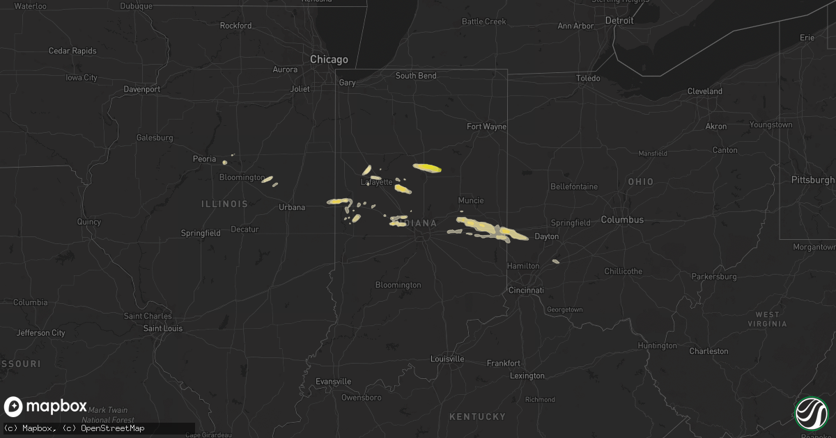
Hail Map in Indiana on May 30, 2019
Get this storm
May 30 map
$229
one time, instant access
Download today. No call, no setup
Keep the $229
Bought the map and want the full workflow? Apply the entire $229 to a subscription within 7 days. None of it is wasted.
Every map, not just this one
This buys you this map. Subscription and you get every map we run, in the markets you choose from a few cities to whole states to nationwide. Plus real-time alerts the moment a storm fires.
Contact data
Name, contact info, occupancy, even credit band for addresses in the footprint. You go from where it hit to who to call.
Become the source they trust
Unlimited branding weather history reports on demand. You already have the documented answer ready for the property owner, and you are the one who showed up with it.
Property data and RoofTrace estimates
Pull up any address you have got, its value and the exact code rules for that jurisdiction, straight from One Click Code. Then RoofTrace estimates the squares, pitch, and roof value, priced the way you price.
Storm reports in Indiana
Indiana
| Date | Description |
|---|---|
| 05/30/20196:50 PM CDT | A local report indicates 1.00 inch wind near NEW CASTLE |
| 05/30/20194:22 PM CDT | House and tree damage. No further details at this time. |
| 05/30/20194:15 PM CDT | Grant county sheriff dept reports large tree snapped in half and utility pole damaged. |
| 05/30/20192:49 AM CDT | At 748 PM EDT, a severe thunderstorm was located over New Castle, or 12 miles northwest of Cambridge City, moving east at 30 mph. HAZARD...Quarter size hail. SOURCE...Radar indicated. IMPACT...Damage to vehicles is expected. Locations impacted include... New Castle, Straughn and Greensboro. This includes Interstate 70 between mile markers 122 and 133. |
| 05/30/20191:18 AM CDT | At 618 PM EDT, a severe thunderstorm was located 7 miles east of Frankfort, moving southeast at 25 mph. HAZARD...Quarter size hail. SOURCE...Radar indicated. IMPACT...Damage to vehicles is expected. Locations impacted include... Tipton, Sheridan, Michigantown and Kempton. |
| 05/29/201911:09 PM CDT | At 408 PM EDT, a severe thunderstorm was located 8 miles northwest of Swayzee, or 11 miles southeast of Grissom Afb, moving east at 25 mph. HAZARD...60 mph wind gusts and half dollar size hail. SOURCE...Radar indicated. IMPACT...Hail damage to vehicles is expected. Expect wind damage to roofs, siding, and trees. This severe thunderstorm will remain over mainly rural areas of northeastern Howard County. |
| 05/29/201911:04 PM CDT | At 404 PM EDT, a severe thunderstorm was located 8 miles southeast of Bunker Hill, or 10 miles southeast of Grissom Afb, moving east at 30 mph. HAZARD...60 mph wind gusts and half dollar size hail. SOURCE...Radar indicated. IMPACT...Hail damage to vehicles is expected. Expect wind damage to roofs, siding, and trees. Locations impacted include... Marion, Gas City, Fairmount, Jonesboro, Sweetser, Swayzee, Sims, Converse, Amboy, Home Corner, Michaelsville, Normal, Mier, Jalapa, Herbst, Santa Fe, Hanfield, Wawpecong, Hackleman and Radley. |
| 05/29/20197:15 PM CDT | Tree down on washington road. Time estimated from radar. |
All States Impacted by Hail Map on May 30, 2019
Cities Impacted by Hail Map on May 30, 2019
- Newman Lake, WA
- Fredericksburg, TX
- Llano, TX
- Coleman, TX
- Burkett, TX
- Del Rio, TX
- Rocksprings, TX
- Hillsboro, IN
- Kingman, IN
- Bloomingdale, IN
- Pantego, NC
- Roper, NC
- Grifton, NC
- Kinston, NC
- Dover, NC
- Hallettsville, TX
- West Lafayette, IN
- Rapidan, VA
- Unionville, VA
- Orange, VA
- Whitestown, IN
- Mason, TX
- Fort Stockton, TX
- Red Bluff, CA
- Covington, IN
- Mountain Home, TX
- Ijamsville, MD
- West Friendship, MD
- Damascus, MD
- Cooksville, MD
- Adamstown, MD
- Monrovia, MD
- Frederick, MD
- Jefferson, MD
- Buckeystown, MD
- Mount Airy, MD
- Woodbine, MD
- Clarksburg, MD
- Glenwood, MD
- Leakey, TX
- Hunt, TX
- Stonewall, TX
- Sonora, TX
- Eldorado, TX
- Greensboro, MD
- Coyanosa, TX
- Chico, CA
- Corning, CA
- Lebanon, IN
- Comstock, TX
- New Paris, OH
- Lewisville, IN
- Hagerstown, IN
- Markleville, IN
- Cambridge City, IN
- Boston, IN
- Centerville, IN
- New Lebanon, OH
- Lewisburg, OH
- Middletown, IN
- Shirley, IN
- Camden, OH
- Richmond, IN
- Milton, IN
- Falmouth, IN
- Straughn, IN
- New Castle, IN
- West Alexandria, OH
- Eaton, OH
- Brownsville, IN
- Liberty, IN
- Connersville, IN
- Farmersville, OH
- Greens Fork, IN
- Quemado, TX
- Clearlake, CA
- Lower Lake, CA
- Menard, TX
- Westpoint, IN
- Lafayette, IN
- Wingate, IN
- Uvalde, TX
- Biggs, CA
- Oroville, CA
- Gridley, CA
- Johnson City, TX
- Hye, TX
- Aroda, VA
- Somerset, VA
- Ruckersville, VA
- Fredericksburg, VA
- Spotsylvania, VA
- Rochelle, VA
- Barboursville, VA
- Rhoadesville, VA
- Locust Grove, VA
- Forbestown, CA
- Strawberry Valley, CA
- Bristow, VA
- Fairfax, VA
- Catharpin, VA
- Fairfax Station, VA
- Gainesville, VA
- Clifton, VA
- Broad Run, VA
- Haymarket, VA
- Centreville, VA
- The Plains, VA
- Manassas, VA
- Brackettville, TX
- Goodfield, IL
- Eureka, IL
- Congerville, IL
- Deer Creek, IL
- Sweetwater, TX
- Nolan, TX
- Merkel, TX
- Dryden, TX
- Ozona, TX
- Gonzales, TX
- Jamestown, IN
- Faison, NC
- Mount Olive, NC
- Warsaw, NC
- Roscoe, TX
- Crystal City, TX
- Willows, CA
- Orland, CA
- Glenn, CA
- London, TX
- Berry Creek, CA
- Sprague, WA
- Mulberry, IN
- Frankfort, IN
- Michigantown, IN
- Bath, NC
- Washington, NC
- Pinetown, NC
- Chocowinity, NC
- Big Wells, TX
- Asherton, TX
- Ingram, TX
- Challenge, CA
- Snyder, TX
- Colville, WA
- Arnold, MD
- Gibson Island, MD
- Reva, VA
- Vanceboro, NC
- Ayden, NC
- Attica, IN
- Danville, IL
- Williamsport, IN
- Bismarck, IL
- State Line, IN
- Veedersburg, IN
- Kokomo, IN
- Converse, IN
- Miami, IN
- Greentown, IN
- Bunker Hill, IN
- Amboy, IN
- Galveston, IN
- Walton, IN
- Whitleyville, TN
- Moss, TN
- Willow City, TX
- Sheffield, TX
- Iraan, TX
- Cost, TX
- Laredo, TX
- Midland, TX
- Crawfordsville, IN
- Lizton, IN
- Brownsburg, IN
- Pittsboro, IN
- North Salem, IN
- Forest Ranch, CA
- Magalia, CA
- Paradise, CA
- Trenton, NC
- Cutler, IN
- Rossville, IN
- Radiant, VA
- Pioche, NV
- Secor, IL
- Marshall, IN
- Batesville, TX
- Hamilton City, CA
- Columbia, NC
- Milford, DE
- Charlottesville, IN
- Knightstown, IN
- Greenfield, IN
- Tuscola, TX
- La Pryor, TX
- Cuero, TX
- Battle Ground, IN
- Camptonville, CA
- Alpine, TX
- Northport, WA
- McCamey, TX
- Brownwood, TX
- Polson, MT
- Celina, TN
- Hamlin, TX
- Arrowsmith, IL
- Saybrook, IL
- Grandfalls, TX
- Pecos, TX
- Fairmount, IN
- Jonesboro, IN
- Hartford City, IN
- Gas City, IN
- Upland, IN
- Dexter, NM
- Hagerman, NM
- Weimar, TX
- La Grange, NC
- Hookerton, NC
- Cove City, NC
- Seven Springs, NC
- Grimesland, NC
- Deep Run, NC
- Jenkins, KY
- Queen Anne, MD
- Ridgely, MD
- Harrington, DE
- Felton, DE
- Chattaroy, WA
- Roseboro, NC
- Salemburg, NC
- Autryville, NC
- Republic, WA
- Greenwood, DE
- Lincoln, DE
- Goldsboro, MD
- Milton, DE
- Centreville, MD
- Houston, DE
- Eagle Pass, TX
- Yoakum, TX
- Shiner, TX
- New Ross, IN
- Davenport, WA
- House, NM
- Cotulla, TX
- Elk, WA
- Clinton, NC
- Imperial, TX
- Middletown, MD
- Gaithersburg, MD
- Brookeville, MD
- Braddock Heights, MD
- Glenelg, MD
- Plymouth, NC
- Novice, TX
- Swayzee, IN
- Cheney, WA
- Ernul, NC
- Valley, WA
- Moscow, ID
- Midkiff, TX
- Rushville, IN
- Oregonia, OH
- Clarksville, OH
- Calypso, NC
- Brookston, IN
- Kettle Falls, WA
- El Campo, TX
- Winterville, NC
- Greenville, NC
- Louise, TX
- Marion, IN
- Otterbein, IN
- Medina, TX
- Mitchells, VA
- Culpeper, VA
- Columbus, TX
- Gifford, WA
- Fort Hancock, TX
- Waynesville, OH
- Nixon, TX
- Rosharon, TX
- Belhaven, NC
- Greenville, OH
- Junction, TX
- Bellflower, IL
- Foosland, IL
- Kerrville, TX
- Winters, TX
- Manvel, TX
- Hext, TX
- Marfa, TX
- Marathon, TX
- Fort Davis, TX
- Valentine, TX
- New Market, MD


