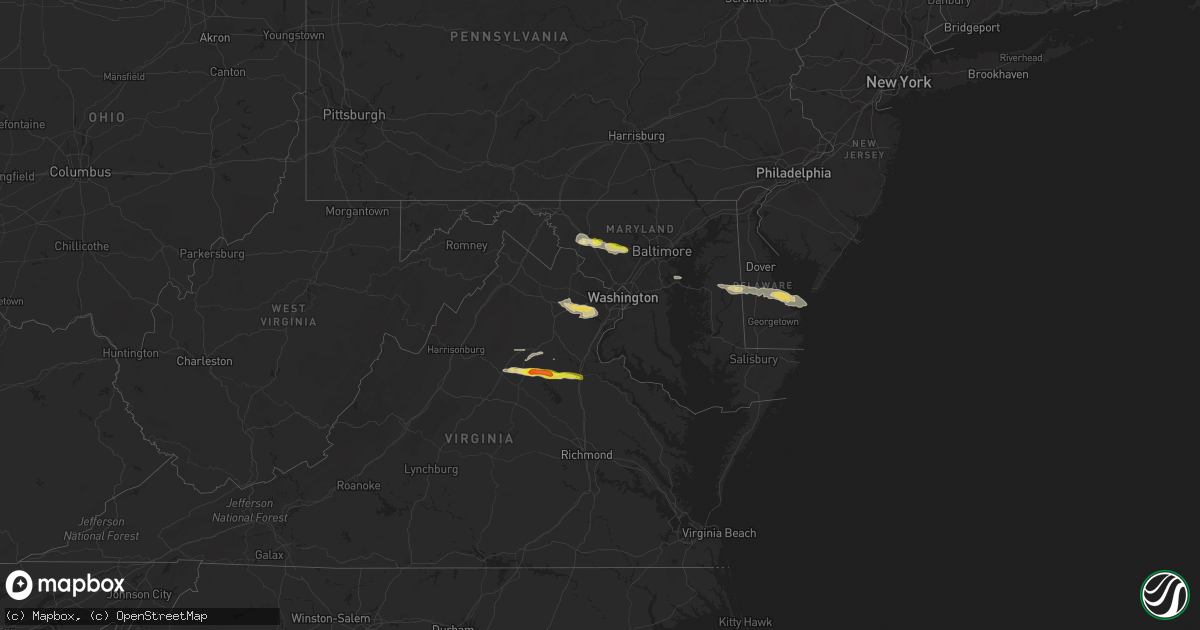
Hail Map in Maryland on May 30, 2019
Get this storm
May 30 map
$229
one time, instant access
Download today. No call, no setup
Keep the $229
Bought the map and want the full workflow? Apply the entire $229 to a subscription within 7 days. None of it is wasted.
Every map, not just this one
This buys you this map. Subscription and you get every map we run, in the markets you choose from a few cities to whole states to nationwide. Plus real-time alerts the moment a storm fires.
Contact data
Name, contact info, occupancy, even credit band for addresses in the footprint. You go from where it hit to who to call.
Become the source they trust
Unlimited branding weather history reports on demand. You already have the documented answer ready for the property owner, and you are the one who showed up with it.
Property data and RoofTrace estimates
Pull up any address you have got, its value and the exact code rules for that jurisdiction, straight from One Click Code. Then RoofTrace estimates the squares, pitch, and roof value, priced the way you price.
Storm reports in Maryland
Maryland
| Date | Description |
|---|---|
| 05/30/20194:06 PM CDT | Trees down just east of cambridge. |
| 05/30/20194:05 PM CDT | Wires down in preston. Time estimated by radar. |
| 05/30/20193:54 PM CDT | A local report indicates 58 MPH wind near 14 ENE DARES BEACH |
| 05/30/20193:54 PM CDT | A local report indicates 58 MPH wind near 19 E CHESAPEAKE BEACH |
| 05/30/20193:54 PM CDT | A local report indicates 58 MPH wind near OXFORD |
| 05/30/20193:45 PM CDT | Trees and wired down in goldsboro. Time estimated by radar. |
| 05/30/20193:40 PM CDT | Trees and wires down in greensboro. Time estimated by radar. |
| 05/30/20193:35 PM CDT | Trees and wired down in ridgely. Time based on radar. |
| 05/30/20193:35 PM CDT | Straight-line winds estimated between 60 and 70 mph uprooted or snapped large limbs from 15 trees. Delayed report from thursday afternoon. |
| 05/30/20193:30 PM CDT | Reports of trees down and power outages near the queen anne area along the queen annes and talbot county border. Time estimated from radar. |
| 05/30/20192:53 PM CDT | Telephone phone poles down on key highway near mccomas street. |
| 05/30/20192:51 PM CDT | Tree down on a house in the 3200 block of maygreen avenue. |
| 05/30/20192:48 PM CDT | Several trees down in the area |
| 05/30/20192:37 PM CDT | Tree down on house on riverside circle. Multiple trees down in the area. |
| 05/30/20192:37 PM CDT | Free-standing traffic light down at intersection of martin luther king blvd and pennsylvania ave per baltimore sun image. |
| 05/30/20192:35 PM CDT | Traffic pole down near the intersection of martin luthor king jr. Blvd and pennsylvania ave. |
| 05/30/20192:26 PM CDT | Roof damage to a shop in the 400 block of route 32. |
| 05/30/20192:26 PM CDT | Roof damage to a shop in the 400 block of route 32. |
| 05/30/20192:22 PM CDT | Tornado confirmed by klwx wsr-88d debris ball signature coincident with faa tdwr bwi base velocity... Coupled with credible video from the area. Nws storm survey will b |
| 05/30/20192:20 PM CDT | Ef1 tornado with estimated peak winds of 100 mph. Path length 4.5 miles... Max width 100 yards. Time on ground from 320-327 pm edt. Storm motion was ese 40 mph. |
| 05/30/20192:17 PM CDT | A local report indicates 1.00 inch wind near LISBON |
| 05/30/20192:06 PM CDT | Several reports of trees and wires down. |
| 05/30/20192:06 PM CDT | Tree down on the 28600 block of kemptown road. |
| 05/30/20192:06 PM CDT | Tree down on the 29010 block of ridge road. |
| 05/30/20191:54 PM CDT | A local report indicates 71 MPH wind near 2 W NEW MARKET |
| 05/30/20191:51 PM CDT | Tree down on the 4600 block of araby church road. |
| 05/30/20191:48 PM CDT | Ef0 tornado with estimated peak winds of 85 mph. Path length 6.5 mile... Discontinuous damage path... Max width 75 yards. Time on ground from 248-259 pm edt. Storm moti |
| 05/29/201911:33 PM CDT | At 432 PM EDT, a severe thunderstorm was located near Breezy Point, moving east at 45 mph. HAZARD...60 mph wind gusts and penny size hail. SOURCE...Radar indicated. IMPACT...Expect damage to trees and powerlines. This severe thunderstorm will be near, Cambridge and University Of Maryland Center For Environmental Studies around 455 PM EDT. Secretary around 505 PM EDT. Hurlock around 510 PM EDT. Vienna around 515 PM EDT.Other locations impacted by this severe thunderstorm include Madison,Brookview, Eldorado, Woolford, Hudson, East New Market, Church Creek,Bucktown, Linkwood and Lloyds. |
| 05/29/201911:03 PM CDT | At 403 PM EDT, a severe thunderstorm was located over Aquia Creek, moving east at 40 mph. HAZARD...60 mph wind gusts. SOURCE...Radar indicated. IMPACT...Damaging winds will cause some trees and large branches to fall. This could injure those outdoors, as well as damage homes and vehicles. Roadways may become blocked by downed trees. Localized power outages are possible. Unsecured light objects may become projectiles. Locations impacted include... Stafford, La Plata, King George, Woodbridge, Dahlgren, Quantico, Fairview Beach, Potomac Creek, Aquia Creek, Port Tobacco River, Popes Creek, Triangle, Dumfries, Wicomico, Cherry Hill, Bryans Road, Falmouth, Mason Neck, Potomac Heights and Pomfret. |
| 05/29/201910:53 PM CDT | At 352 PM EDT, a severe thunderstorm was located near Gibson Island, moving east at 35 mph. HAZARD...60 mph wind gusts and quarter size hail. SOURCE...Radar indicated. IMPACT...Minor damage to vehicles is possible. Wind damage to roofs, siding, trees, and power lines is possible. Locations impacted include... Centerville, Chestertown, Centreville, Rock Hall, Church Hill, Millington, Sudlersville, Queen Anne, Old Town, Grasonville, Starr, Morgnec, Crumpton, Skipton, Langford, Matthews, Overton, Starkey Corner, Wye Mills and Cordova. |
| 05/29/201910:42 PM CDT | At 342 PM EDT, a severe thunderstorm was located over Fort Hunt, moving east at 30 mph. HAZARD...70 mph wind gusts and quarter size hail. SOURCE...Radar indicated. IMPACT...Damaging winds will cause some trees and large branches to fall. This could injure those outdoors, as well as damage homes and vehicles. Roadways may become blocked by downed trees. Localized power outages are possible. Unsecured light objects may become projectiles. Locations impacted include... Waldorf, Clinton, Springfield, Fort Washington, Fort Hunt, Groveton, Huntington, Fort Belvoir, Lincolnia, Lorton, Franconia, Oxon Hill, Hybla Valley, Newington, Rosaryville, Friendly, Marlton, Dunkirk, Saint Charles and Mount Vernon. |
| 05/29/201910:33 PM CDT | At 332 PM EDT, a severe thunderstorm was located near Ellicott City, or near Columbia, moving east at 45 mph. HAZARD...70 mph wind gusts. SOURCE...Radar indicated. IMPACT...Damaging winds will cause some trees and large branches to fall. This could injure those outdoors, as well as damage homes and vehicles. Roadways may become blocked by downed trees. Localized power outages are possible. Unsecured light objects may become projectiles. Locations impacted include... Baltimore, Columbia, Severn, Pikesville, Middle River, Elkridge, Riviera Beach, Baltimore-Washington Airport, Gibson Island, Bodkin Point, Sillery Bay, Millers Island, North Point State Park, Pinehurst, Back River, Sparrows Point, Glen Burnie, Ellicott City, Dundalk and Towson. |
| 05/29/20199:53 PM CDT | At 253 PM EDT, a severe thunderstorm was located over Linganore-Bartonsville, or near Harry Grove Stadium, moving east at 45 mph. HAZARD...Ping pong ball size hail and 60 mph wind gusts. SOURCE...Radar indicated. IMPACT...Damaging winds will cause some trees and large branches to fall. This could injure those outdoors, as well as damage homes and vehicles. Roadways may become blocked by downed trees. Localized power outages are possible. Unsecured light objects may become projectiles. Locations impacted include... Columbia, Frederick, Pikesville, Damascus, Harry Grove Stadium, Ellicott City, Catonsville, Woodlawn, Randallstown, Owings Mills, Eldersburg, Milford Mill, Reisterstown, Lochearn, Ballenger Creek, Mount Airy, Walkersville, Sykesville, Oakland and New Market. |
| 05/29/20199:32 PM CDT | At 232 PM EDT, a severe thunderstorm was located over The Plains, or 11 miles north of Warrenton, moving east at 40 mph. HAZARD...60 mph wind gusts and quarter size hail. SOURCE...Radar indicated. IMPACT...Damaging winds will cause some trees and large branches to fall. This could injure those outdoors, as well as damage homes and vehicles. Roadways may become blocked by downed trees. Localized power outages are possible. Unsecured light objects may become projectiles. Locations impacted include... Centreville, Reston, Annandale, Springfield, South Riding, Herndon, Fairfax, Vienna, Brambleton, Mantua, Pimmit Hills, Dulles International Airport, Potomac, Burke, Linton Hall, Oakton, Sterling, Chantilly, Tysons Corner and Lorton. |
All States Impacted by Hail Map on May 30, 2019
Cities Impacted by Hail Map on May 30, 2019
- Newman Lake, WA
- Fredericksburg, TX
- Llano, TX
- Coleman, TX
- Burkett, TX
- Del Rio, TX
- Rocksprings, TX
- Hillsboro, IN
- Kingman, IN
- Bloomingdale, IN
- Pantego, NC
- Roper, NC
- Grifton, NC
- Kinston, NC
- Dover, NC
- Hallettsville, TX
- West Lafayette, IN
- Rapidan, VA
- Unionville, VA
- Orange, VA
- Whitestown, IN
- Mason, TX
- Fort Stockton, TX
- Red Bluff, CA
- Covington, IN
- Mountain Home, TX
- Ijamsville, MD
- West Friendship, MD
- Damascus, MD
- Cooksville, MD
- Adamstown, MD
- Monrovia, MD
- Frederick, MD
- Jefferson, MD
- Buckeystown, MD
- Mount Airy, MD
- Woodbine, MD
- Clarksburg, MD
- Glenwood, MD
- Leakey, TX
- Hunt, TX
- Stonewall, TX
- Sonora, TX
- Eldorado, TX
- Greensboro, MD
- Coyanosa, TX
- Chico, CA
- Corning, CA
- Lebanon, IN
- Comstock, TX
- New Paris, OH
- Lewisville, IN
- Hagerstown, IN
- Markleville, IN
- Cambridge City, IN
- Boston, IN
- Centerville, IN
- New Lebanon, OH
- Lewisburg, OH
- Middletown, IN
- Shirley, IN
- Camden, OH
- Richmond, IN
- Milton, IN
- Falmouth, IN
- Straughn, IN
- New Castle, IN
- West Alexandria, OH
- Eaton, OH
- Brownsville, IN
- Liberty, IN
- Connersville, IN
- Farmersville, OH
- Greens Fork, IN
- Quemado, TX
- Clearlake, CA
- Lower Lake, CA
- Menard, TX
- Westpoint, IN
- Lafayette, IN
- Wingate, IN
- Uvalde, TX
- Biggs, CA
- Oroville, CA
- Gridley, CA
- Johnson City, TX
- Hye, TX
- Aroda, VA
- Somerset, VA
- Ruckersville, VA
- Fredericksburg, VA
- Spotsylvania, VA
- Rochelle, VA
- Barboursville, VA
- Rhoadesville, VA
- Locust Grove, VA
- Forbestown, CA
- Strawberry Valley, CA
- Bristow, VA
- Fairfax, VA
- Catharpin, VA
- Fairfax Station, VA
- Gainesville, VA
- Clifton, VA
- Broad Run, VA
- Haymarket, VA
- Centreville, VA
- The Plains, VA
- Manassas, VA
- Brackettville, TX
- Goodfield, IL
- Eureka, IL
- Congerville, IL
- Deer Creek, IL
- Sweetwater, TX
- Nolan, TX
- Merkel, TX
- Dryden, TX
- Ozona, TX
- Gonzales, TX
- Jamestown, IN
- Faison, NC
- Mount Olive, NC
- Warsaw, NC
- Roscoe, TX
- Crystal City, TX
- Willows, CA
- Orland, CA
- Glenn, CA
- London, TX
- Berry Creek, CA
- Sprague, WA
- Mulberry, IN
- Frankfort, IN
- Michigantown, IN
- Bath, NC
- Washington, NC
- Pinetown, NC
- Chocowinity, NC
- Big Wells, TX
- Asherton, TX
- Ingram, TX
- Challenge, CA
- Snyder, TX
- Colville, WA
- Arnold, MD
- Gibson Island, MD
- Reva, VA
- Vanceboro, NC
- Ayden, NC
- Attica, IN
- Danville, IL
- Williamsport, IN
- Bismarck, IL
- State Line, IN
- Veedersburg, IN
- Kokomo, IN
- Converse, IN
- Miami, IN
- Greentown, IN
- Bunker Hill, IN
- Amboy, IN
- Galveston, IN
- Walton, IN
- Whitleyville, TN
- Moss, TN
- Willow City, TX
- Sheffield, TX
- Iraan, TX
- Cost, TX
- Laredo, TX
- Midland, TX
- Crawfordsville, IN
- Lizton, IN
- Brownsburg, IN
- Pittsboro, IN
- North Salem, IN
- Forest Ranch, CA
- Magalia, CA
- Paradise, CA
- Trenton, NC
- Cutler, IN
- Rossville, IN
- Radiant, VA
- Pioche, NV
- Secor, IL
- Marshall, IN
- Batesville, TX
- Hamilton City, CA
- Columbia, NC
- Milford, DE
- Charlottesville, IN
- Knightstown, IN
- Greenfield, IN
- Tuscola, TX
- La Pryor, TX
- Cuero, TX
- Battle Ground, IN
- Camptonville, CA
- Alpine, TX
- Northport, WA
- McCamey, TX
- Brownwood, TX
- Polson, MT
- Celina, TN
- Hamlin, TX
- Arrowsmith, IL
- Saybrook, IL
- Grandfalls, TX
- Pecos, TX
- Fairmount, IN
- Jonesboro, IN
- Hartford City, IN
- Gas City, IN
- Upland, IN
- Dexter, NM
- Hagerman, NM
- Weimar, TX
- La Grange, NC
- Hookerton, NC
- Cove City, NC
- Seven Springs, NC
- Grimesland, NC
- Deep Run, NC
- Jenkins, KY
- Queen Anne, MD
- Ridgely, MD
- Harrington, DE
- Felton, DE
- Chattaroy, WA
- Roseboro, NC
- Salemburg, NC
- Autryville, NC
- Republic, WA
- Greenwood, DE
- Lincoln, DE
- Goldsboro, MD
- Milton, DE
- Centreville, MD
- Houston, DE
- Eagle Pass, TX
- Yoakum, TX
- Shiner, TX
- New Ross, IN
- Davenport, WA
- House, NM
- Cotulla, TX
- Elk, WA
- Clinton, NC
- Imperial, TX
- Middletown, MD
- Gaithersburg, MD
- Brookeville, MD
- Braddock Heights, MD
- Glenelg, MD
- Plymouth, NC
- Novice, TX
- Swayzee, IN
- Cheney, WA
- Ernul, NC
- Valley, WA
- Moscow, ID
- Midkiff, TX
- Rushville, IN
- Oregonia, OH
- Clarksville, OH
- Calypso, NC
- Brookston, IN
- Kettle Falls, WA
- El Campo, TX
- Winterville, NC
- Greenville, NC
- Louise, TX
- Marion, IN
- Otterbein, IN
- Medina, TX
- Mitchells, VA
- Culpeper, VA
- Columbus, TX
- Gifford, WA
- Fort Hancock, TX
- Waynesville, OH
- Nixon, TX
- Rosharon, TX
- Belhaven, NC
- Greenville, OH
- Junction, TX
- Bellflower, IL
- Foosland, IL
- Kerrville, TX
- Winters, TX
- Manvel, TX
- Hext, TX
- Marfa, TX
- Marathon, TX
- Fort Davis, TX
- Valentine, TX
- New Market, MD


