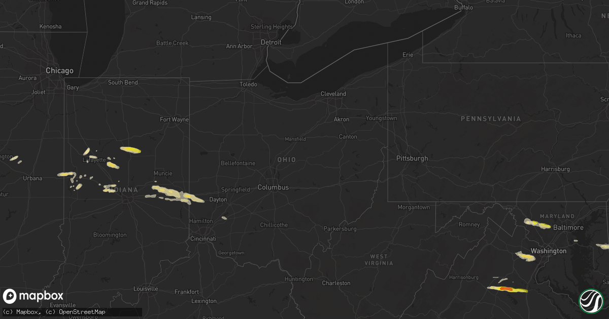
Hail Map in Ohio on May 30, 2019
Get this storm
May 30 map
$229
one time, instant access
Download today. No call, no setup
Keep the $229
Bought the map and want the full workflow? Apply the entire $229 to a subscription within 7 days. None of it is wasted.
Every map, not just this one
This buys you this map. Subscription and you get every map we run, in the markets you choose from a few cities to whole states to nationwide. Plus real-time alerts the moment a storm fires.
Contact data
Name, contact info, occupancy, even credit band for addresses in the footprint. You go from where it hit to who to call.
Become the source they trust
Unlimited branding weather history reports on demand. You already have the documented answer ready for the property owner, and you are the one who showed up with it.
Property data and RoofTrace estimates
Pull up any address you have got, its value and the exact code rules for that jurisdiction, straight from One Click Code. Then RoofTrace estimates the squares, pitch, and roof value, priced the way you price.
Storm reports in Ohio
Ohio
| Date | Description |
|---|---|
| 05/30/20194:16 PM CDT | Tree down across stony creek drive. |
| 05/30/20193:45 PM CDT | 2 trees and a power pole down. |
| 05/30/20193:38 PM CDT | 1 tree down. |
| 05/30/20195:11 AM CDT | At 1011 PM EDT, a severe thunderstorm was located near Waynesville, moving east at 30 mph. HAZARD...60 mph wind gusts and quarter size hail. SOURCE...Radar indicated. IMPACT...Minor hail damage to vehicles is possible. Expect wind damage to trees and power lines. Locations impacted include... Wilmington, Waynesville, Sabina, Leesburg, New Vienna, Clarksville, Harveysburg, Martinsville, Corwin, Highland, Melvin, Fort Ancient, Samantha, Oakland, Lees Creek, Caesar Creek State Park, Morrisville, Ogden, Kingman and Interstate 71 at US Route 68.This includes I-71 in Ohio between mile markers 35 and 53. |
| 05/30/20193:09 AM CDT | At 808 PM EDT, a severe thunderstorm was located over Hagerstown, moving east at 35 mph. HAZARD...60 mph wind gusts and quarter size hail. SOURCE...Radar indicated. IMPACT...Minor hail damage to vehicles is possible. Expect wind damage to trees and power lines. Locations impacted include... Richmond, Centerville, Cambridge City, Hagerstown, Dublin, Franklin, Abington, Greens Fork, East Germantown, Spring Grove, Mount Auburn, Middleboro, Jacksonburg, Interstate 70 at Exit 145 and Williamsburg.This includes the following Interstates... I-70 in Indiana between mile markers 134 and 156. I-70 in Ohio near mile marker 0. |
| 05/29/201911:59 PM CDT | At 458 PM EDT, severe thunderstorms were located along a line extending from near Avon Lake to near North Ridgeville, moving east at 45 mph. HAZARD...60 mph wind gusts. SOURCE...Radar indicated. IMPACT...Expect damage to trees and power lines. Locations impacted include... Cleveland, Parma, Lakewood, Euclid, Cleveland Heights, Strongsville, Brunswick, Westlake, North Royalton, Solon, Warrensville Heights, Highland Hills, North Olmsted, Garfield Heights, Shaker Heights, Maple Heights, South Euclid, Parma Heights, Rocky River and Broadview Heights. |
| 05/29/201911:24 PM CDT | At 424 PM EDT, a severe thunderstorm was located near Western Vermilion, or near Vermilion, moving east at 40 mph. HAZARD...60 mph wind gusts. SOURCE...Radar indicated. IMPACT...Expect damage to trees and power lines. Locations impacted include... Lorain, Elyria, Western Vermilion, Vermilion, North Ridgeville, Avon Lake, Amherst, Grafton, Avon, Sheffield Lake, Eaton, Oberlin, Sheffield, South Amherst, Berlin Heights, Birmingham and Eaton Estates. |
All States Impacted by Hail Map on May 30, 2019
Cities Impacted by Hail Map on May 30, 2019
- Newman Lake, WA
- Fredericksburg, TX
- Llano, TX
- Coleman, TX
- Burkett, TX
- Del Rio, TX
- Rocksprings, TX
- Hillsboro, IN
- Kingman, IN
- Bloomingdale, IN
- Pantego, NC
- Roper, NC
- Grifton, NC
- Kinston, NC
- Dover, NC
- Hallettsville, TX
- West Lafayette, IN
- Rapidan, VA
- Unionville, VA
- Orange, VA
- Whitestown, IN
- Mason, TX
- Fort Stockton, TX
- Red Bluff, CA
- Covington, IN
- Mountain Home, TX
- Ijamsville, MD
- West Friendship, MD
- Damascus, MD
- Cooksville, MD
- Adamstown, MD
- Monrovia, MD
- Frederick, MD
- Jefferson, MD
- Buckeystown, MD
- Mount Airy, MD
- Woodbine, MD
- Clarksburg, MD
- Glenwood, MD
- Leakey, TX
- Hunt, TX
- Stonewall, TX
- Sonora, TX
- Eldorado, TX
- Greensboro, MD
- Coyanosa, TX
- Chico, CA
- Corning, CA
- Lebanon, IN
- Comstock, TX
- New Paris, OH
- Lewisville, IN
- Hagerstown, IN
- Markleville, IN
- Cambridge City, IN
- Boston, IN
- Centerville, IN
- New Lebanon, OH
- Lewisburg, OH
- Middletown, IN
- Shirley, IN
- Camden, OH
- Richmond, IN
- Milton, IN
- Falmouth, IN
- Straughn, IN
- New Castle, IN
- West Alexandria, OH
- Eaton, OH
- Brownsville, IN
- Liberty, IN
- Connersville, IN
- Farmersville, OH
- Greens Fork, IN
- Quemado, TX
- Clearlake, CA
- Lower Lake, CA
- Menard, TX
- Westpoint, IN
- Lafayette, IN
- Wingate, IN
- Uvalde, TX
- Biggs, CA
- Oroville, CA
- Gridley, CA
- Johnson City, TX
- Hye, TX
- Aroda, VA
- Somerset, VA
- Ruckersville, VA
- Fredericksburg, VA
- Spotsylvania, VA
- Rochelle, VA
- Barboursville, VA
- Rhoadesville, VA
- Locust Grove, VA
- Forbestown, CA
- Strawberry Valley, CA
- Bristow, VA
- Fairfax, VA
- Catharpin, VA
- Fairfax Station, VA
- Gainesville, VA
- Clifton, VA
- Broad Run, VA
- Haymarket, VA
- Centreville, VA
- The Plains, VA
- Manassas, VA
- Brackettville, TX
- Goodfield, IL
- Eureka, IL
- Congerville, IL
- Deer Creek, IL
- Sweetwater, TX
- Nolan, TX
- Merkel, TX
- Dryden, TX
- Ozona, TX
- Gonzales, TX
- Jamestown, IN
- Faison, NC
- Mount Olive, NC
- Warsaw, NC
- Roscoe, TX
- Crystal City, TX
- Willows, CA
- Orland, CA
- Glenn, CA
- London, TX
- Berry Creek, CA
- Sprague, WA
- Mulberry, IN
- Frankfort, IN
- Michigantown, IN
- Bath, NC
- Washington, NC
- Pinetown, NC
- Chocowinity, NC
- Big Wells, TX
- Asherton, TX
- Ingram, TX
- Challenge, CA
- Snyder, TX
- Colville, WA
- Arnold, MD
- Gibson Island, MD
- Reva, VA
- Vanceboro, NC
- Ayden, NC
- Attica, IN
- Danville, IL
- Williamsport, IN
- Bismarck, IL
- State Line, IN
- Veedersburg, IN
- Kokomo, IN
- Converse, IN
- Miami, IN
- Greentown, IN
- Bunker Hill, IN
- Amboy, IN
- Galveston, IN
- Walton, IN
- Whitleyville, TN
- Moss, TN
- Willow City, TX
- Sheffield, TX
- Iraan, TX
- Cost, TX
- Laredo, TX
- Midland, TX
- Crawfordsville, IN
- Lizton, IN
- Brownsburg, IN
- Pittsboro, IN
- North Salem, IN
- Forest Ranch, CA
- Magalia, CA
- Paradise, CA
- Trenton, NC
- Cutler, IN
- Rossville, IN
- Radiant, VA
- Pioche, NV
- Secor, IL
- Marshall, IN
- Batesville, TX
- Hamilton City, CA
- Columbia, NC
- Milford, DE
- Charlottesville, IN
- Knightstown, IN
- Greenfield, IN
- Tuscola, TX
- La Pryor, TX
- Cuero, TX
- Battle Ground, IN
- Camptonville, CA
- Alpine, TX
- Northport, WA
- McCamey, TX
- Brownwood, TX
- Polson, MT
- Celina, TN
- Hamlin, TX
- Arrowsmith, IL
- Saybrook, IL
- Grandfalls, TX
- Pecos, TX
- Fairmount, IN
- Jonesboro, IN
- Hartford City, IN
- Gas City, IN
- Upland, IN
- Dexter, NM
- Hagerman, NM
- Weimar, TX
- La Grange, NC
- Hookerton, NC
- Cove City, NC
- Seven Springs, NC
- Grimesland, NC
- Deep Run, NC
- Jenkins, KY
- Queen Anne, MD
- Ridgely, MD
- Harrington, DE
- Felton, DE
- Chattaroy, WA
- Roseboro, NC
- Salemburg, NC
- Autryville, NC
- Republic, WA
- Greenwood, DE
- Lincoln, DE
- Goldsboro, MD
- Milton, DE
- Centreville, MD
- Houston, DE
- Eagle Pass, TX
- Yoakum, TX
- Shiner, TX
- New Ross, IN
- Davenport, WA
- House, NM
- Cotulla, TX
- Elk, WA
- Clinton, NC
- Imperial, TX
- Middletown, MD
- Gaithersburg, MD
- Brookeville, MD
- Braddock Heights, MD
- Glenelg, MD
- Plymouth, NC
- Novice, TX
- Swayzee, IN
- Cheney, WA
- Ernul, NC
- Valley, WA
- Moscow, ID
- Midkiff, TX
- Rushville, IN
- Oregonia, OH
- Clarksville, OH
- Calypso, NC
- Brookston, IN
- Kettle Falls, WA
- El Campo, TX
- Winterville, NC
- Greenville, NC
- Louise, TX
- Marion, IN
- Otterbein, IN
- Medina, TX
- Mitchells, VA
- Culpeper, VA
- Columbus, TX
- Gifford, WA
- Fort Hancock, TX
- Waynesville, OH
- Nixon, TX
- Rosharon, TX
- Belhaven, NC
- Greenville, OH
- Junction, TX
- Bellflower, IL
- Foosland, IL
- Kerrville, TX
- Winters, TX
- Manvel, TX
- Hext, TX
- Marfa, TX
- Marathon, TX
- Fort Davis, TX
- Valentine, TX
- New Market, MD


