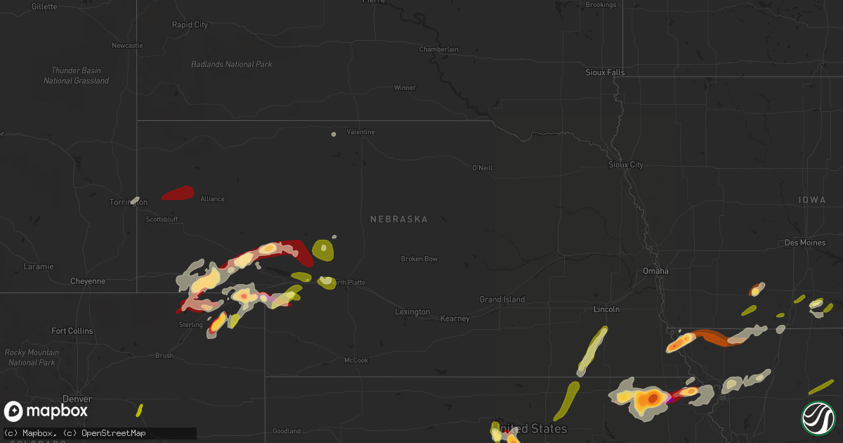
Hail Map in Nebraska on May 28, 2013
Get this storm
May 28 map
$229
one time, instant access
Download today. No call, no setup
Keep the $229
Bought the map and want the full workflow? Apply the entire $229 to a subscription within 7 days. None of it is wasted.
Every map, not just this one
This buys you this map. Subscription and you get every map we run, in the markets you choose from a few cities to whole states to nationwide. Plus real-time alerts the moment a storm fires.
Contact data
Name, contact info, occupancy, even credit band for addresses in the footprint. You go from where it hit to who to call.
Become the source they trust
Unlimited branding weather history reports on demand. You already have the documented answer ready for the property owner, and you are the one who showed up with it.
Property data and RoofTrace estimates
Pull up any address you have got, its value and the exact code rules for that jurisdiction, straight from One Click Code. Then RoofTrace estimates the squares, pitch, and roof value, priced the way you price.
Storm reports in Nebraska
Nebraska
| Date | Description |
|---|---|
| 05/28/20136:59 PM CDT | Pea to quarters. |
| 05/28/20136:30 PM CDT | Event duration 20 minutes. |
| 05/28/20136:15 PM CDT | A local report indicates 1.00 inch wind near 3 NW LORENZO |
| 05/28/20135:05 PM CDT | Tornado was reported. Has been going up and down. Relayed via alliance warning point. |
| 05/28/20135:00 PM CDT | Golfball to baseball size hail reported in brownville |
| 05/28/20134:45 PM CDT | Delayed report-time estimated by radar. |
| 05/28/20134:35 PM CDT | Hail did not totally cover the ground. Also received one inch of rain from the storm. |
| 05/28/20134:33 PM CDT | Numerous reports of a tornado on the ground 10 to 15 miles north of scottsbluff. Tornado is near state highway 71 north of scottsbluff |
| 05/28/20134:23 PM CDT | Spotter seeing debris 1 mile north of his location. Spotter is located 8n of highway 71. |
| 05/28/20132:30 AM CDT | Winds were estimated at 60 mph. Large limbs were down and metal tractor rim blown 20 ft. |
| 05/28/20131:16 AM CDT | Straightline winds between 65 to 90 mph destroyed a pole barn that measured 73 by 30 feet.the debris hit a second building where visible damage occurred to the roof...s |
| 05/28/201312:50 AM CDT | A local report indicates 1.00 inch wind near 1 NW HERSHEY |
| 05/28/201312:25 AM CDT | Estimated quarter size hail. |
| 05/28/201312:25 AM CDT | Reports of small twigs blown down with wind estimated at 50 mph. |
| 05/28/201312:25 AM CDT | Reports of multiple 4inch diameter tree limbs down. Winds estimated at 60 mph. |
| 05/27/201311:50 PM CDT | Quarter size hail |
| 05/27/201311:30 PM CDT | A local report indicates 1.00 inch wind near 3 NW GRANT |
| 05/27/201310:37 PM CDT | A local report indicates 1.50 inch wind near 18 NNE LEWELLEN |
| 05/27/201310:10 PM CDT | A local report indicates 1.75 inch wind near 1 W OSHKOSH |
| 05/27/20138:57 PM CDT | Estimated 50 to 60 mph wind gusts. Heavy rain. Lots of pea size hail in drifts. |
| 05/27/20138:43 PM CDT | A local report indicates 1.00 inch wind near 2 NNE HALLAM |
| 05/27/20138:40 PM CDT | A local report indicates 60 MPH wind near GURLEY |
| 05/27/20138:02 PM CDT | A local report indicates 1.00 inch wind near PLYMOUTH |
| 05/27/20137:54 PM CDT | A local report indicates 58 MPH wind near 2 E PLYMOUTH |
| 05/27/20137:30 PM CDT | Event duration 10 minutes. |
| 05/27/20137:24 PM CDT | Nickel to quarters |
| 05/27/20137:20 PM CDT | Event duration 10 minutes. |
| 05/27/20137:20 PM CDT | Event duration 25 minutes. |
| 05/27/20137:15 PM CDT | Penny to golf ball sized hail |
| 05/27/20137:13 PM CDT | A local report indicates 1.75 inch wind near 6 W SIDNEY |
| 05/27/20137:07 PM CDT | Numerous reports of quarter sized hail in west sidney |
| 05/27/20137:05 PM CDT | A local report indicates 1.00 inch wind near 1 W SIDNEY |
All States Impacted by Hail Map on May 28, 2013
Cities Impacted by Hail Map on May 28, 2013
- Lewellen, NE
- Arthur, NE
- Kinsman, OH
- Jamestown, PA
- Williamsfield, OH
- Greenville, PA
- Atlantic, PA
- Adamsville, PA
- Hartstown, PA
- Andover, OH
- Hadley, PA
- Torrington, WY
- Amarillo, TX
- Wildorado, TX
- Tescott, KS
- Bennington, KS
- Minneapolis, KS
- Iliff, CO
- Crook, CO
- Plains, KS
- Forgan, OK
- Meade, KS
- Lingle, WY
- Ovid, CO
- Brownville, NE
- Rock Port, MO
- Tarkio, MO
- Westboro, MO
- Nemaha, NE
- Barnard, KS
- Friona, TX
- Seneca, KS
- Baileyville, KS
- Goff, KS
- Oneida, KS
- Sabetha, KS
- Corning, KS
- Centralia, KS
- Wetmore, KS
- Allerton, IA
- Corydon, IA
- Humeston, IA
- Sublette, KS
- Satanta, KS
- Julesburg, CO
- Victoria, KS
- Walker, KS
- Hereford, TX
- Vega, TX
- Ashland, KS
- Rosston, OK
- Buffalo, OK
- Protection, KS
- Auburn, NE
- Watson, MO
- Beloit, KS
- Lincoln, KS
- Solomon, KS
- Lucas, KS
- Tipton, KS
- Hunter, KS
- Beverly, KS
- Osborne, KS
- Lenox, IA
- Creston, IA
- Hiawatha, KS
- Highland, KS
- Robinson, KS
- Venango, NE
- Gurley, NE
- Sidney, NE
- Sedgwick, CO
- Chappell, NE
- Muleshoe, TX
- Farwell, TX
- Fleming, CO
- Newcastle, WY
- Vermillion, KS
- Axtell, KS
- Havensville, KS
- Frankfort, KS
- Home, KS
- Powhattan, KS
- Onaga, KS
- Beattie, KS
- Fairview, KS
- Hays, KS
- Schoenchen, KS
- Sterling, CO
- Chariton, IA
- Oshkosh, NE
- Tryon, NE
- Columbus Junction, IA
- Crawfordsville, IA
- Mount Pleasant, IA
- Wapello, IA
- Wayland, IA
- Winfield, IA
- Coldwater, KS
- Lodgepole, NE
- Panhandle, TX
- Adrian, TX
- Potter, NE
- Dalton, NE
- Harrison, NE
- Morrill, NE
- Circleville, KS
- Blue Rapids, KS
- Summerfield, KS
- Netawaka, KS
- Soldier, KS
- Marysville, KS
- Haxtun, CO
- Hershey, NE
- Sutherland, NE
- White Cloud, KS
- Clearfield, IA
- Diagonal, IA
- Brighton, IA
- Bovina, TX
- Pampa, TX
- San Jon, NM
- White Deer, TX
- Groom, TX
- Gate, OK
- Englewood, KS
- Albia, IA
- Eddyville, IA
- Ottumwa, IA
- Pattonsburg, MO
- Maysville, MO
- Weatherby, MO
- Afton, IA
- Parkston, SD
- Dimock, SD
- Lancaster, KS
- Wathena, KS
- Bendena, KS
- Denton, KS
- Oregon, MO
- Troy, KS
- Atchison, KS
- Everest, KS
- Pickering, MO
- Blockton, IA
- Sheridan, MO
- Hatfield, MO
- Redding, IA
- Grant City, MO
- Parnell, MO
- Maryville, MO
- Mount Ayr, IA
- Ravenwood, MO
- Hopkins, MO
- Paxton, NE
- Richland, IA
- Fairfield, IA
- Packwood, IA
- Hallam, NE
- Pickrell, NE
- Clatonia, NE
- Fairbury, NE
- Martell, NE
- Plymouth, NE
- Jansen, NE
- Cortland, NE
- De Witt, NE
- Diller, NE
- Beatrice, NE
- Endicott, NE
- Fort Laramie, WY
- Jay Em, WY
- Yoder, WY
- Wilmore, KS
- Ulysses, KS
- Grant, NE
- Kilgore, NE
- Dix, NE
- Padroni, CO
- Lemoyne, NE
- Peetz, CO
- Lisco, NE
- Lake City, KS
- Saint Joseph, MO
- Savannah, MO
- McFall, MO
- Rea, MO
- Amazonia, MO
- King City, MO
- Union Star, MO
- Cosby, MO
- Amity, MO
- Helena, MO
- Otis, CO
- Big Springs, NE
- Madrid, NE
- Ogallala, NE
- Holyoke, CO
- Kellerton, IA
- Eagleville, MO
- Lamoni, IA
- Mukwonago, WI
- Tripp, SD
- Delmont, SD
- Burlington Junction, MO
- Elmo, MO
- Skidmore, MO
- Clearmont, MO
- Chillicothe, MO
- Wheeling, MO
- Linneus, MO
- Purdin, MO
- Laverne, OK
- Alva, OK
- Freedom, OK
- Deer Trail, CO
- Agate, CO
- Keystone, NE
- Bristolville, OH
- Southington, OH
- Warren, OH
- Farmdale, OH
- Cortland, OH
- West Farmington, OH
- Cochranton, PA
- Orwell, OH
- Rome, OH
- Jefferson, OH
- West Springfield, PA
- Albion, PA
- Conneaut, OH
- Accokeek, MD
- Clinton, MD
- Brandywine, MD
- Upper Marlboro, MD
- Texico, NM
- Skellytown, TX
- Gruver, TX
- Spearman, TX
- Stratford, TX
- Fowler, KS
- Horton, KS
- McCracken, KS
- Agenda, KS
- Haddam, KS
- Clifton, KS
- Mahaska, KS
- Concordia, KS
- Washington, KS
- Morrowville, KS
- Clyde, KS
- Wilber, NE
- Downs, KS
- Glen Elder, KS
- Hemingford, NE
- Alliance, NE
- McCamey, TX
- Crane, TX
- Eagle, WI
- Lovilia, IA
- Cedar, IA
- Oskaloosa, IA
- Hedrick, IA
- Fremont, IA
- Sigourney, IA
- Bedford, IA
- Osceola, IA
- Weldon, IA
- Woodburn, IA
- Grand River, IA
- Blakesburg, IA
- Promise City, IA
- Russell, IA
- Lockridge, IA
- Keithsburg, IL
- Oakville, IA
- Mediapolis, IA
- Seaton, IL
- Washington, IA


