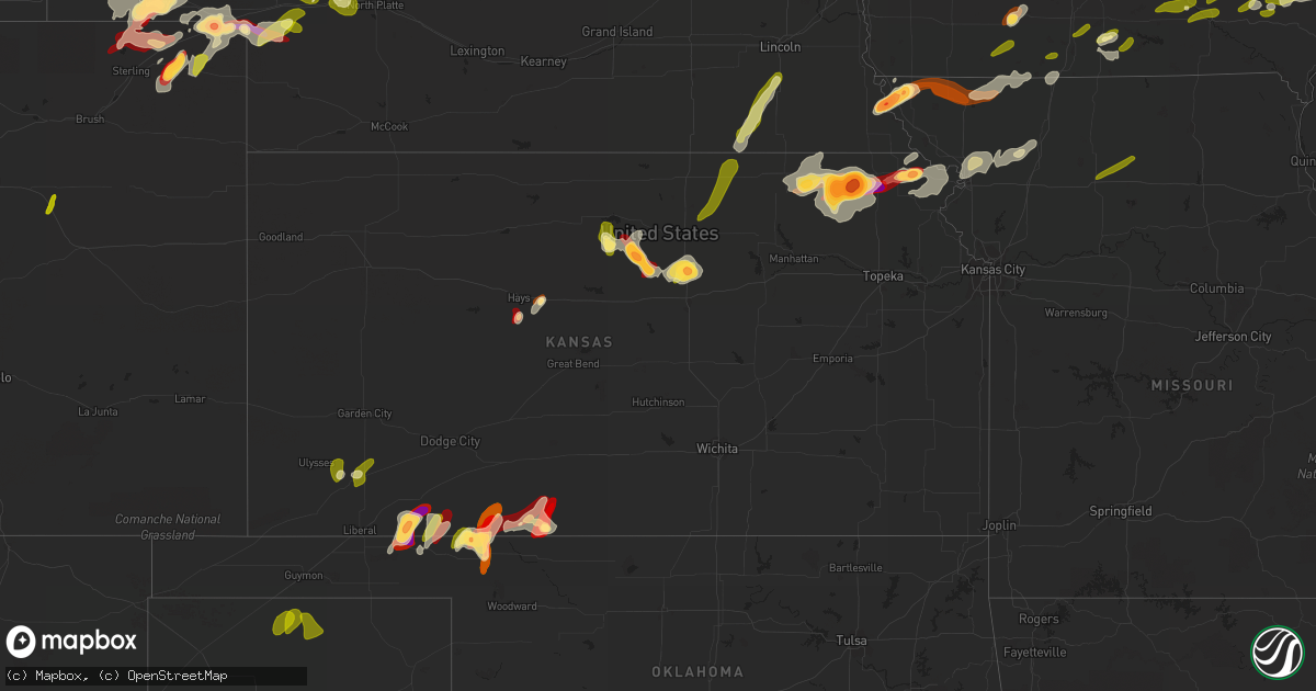
Hail Map in Kansas on May 28, 2013
Get this storm
May 28 map
$229
one time, instant access
Download today. No call, no setup
Keep the $229
Bought the map and want the full workflow? Apply the entire $229 to a subscription within 7 days. None of it is wasted.
Every map, not just this one
This buys you this map. Subscription and you get every map we run, in the markets you choose from a few cities to whole states to nationwide. Plus real-time alerts the moment a storm fires.
Contact data
Name, contact info, occupancy, even credit band for addresses in the footprint. You go from where it hit to who to call.
Become the source they trust
Unlimited branding weather history reports on demand. You already have the documented answer ready for the property owner, and you are the one who showed up with it.
Property data and RoofTrace estimates
Pull up any address you have got, its value and the exact code rules for that jurisdiction, straight from One Click Code. Then RoofTrace estimates the squares, pitch, and roof value, priced the way you price.
Storm reports in Kansas
Kansas
| Date | Description |
|---|---|
| 05/28/20136:58 PM CDT | A local report indicates 65 MPH wind near 4 ESE MINNEAPOLIS |
| 05/28/20136:54 PM CDT | A local report indicates 2.00 inch wind near 3 N ROBINSON |
| 05/28/20136:45 PM CDT | A local report indicates 1.75 inch wind near 4 ESE MINNEAPOLIS |
| 05/28/20136:45 PM CDT | Small tree limbs down |
| 05/28/20136:45 PM CDT | A local report indicates 1.00 inch wind near MORROWVILLE |
| 05/28/20136:45 PM CDT | A local report indicates 1.00 inch wind near 4 SW ROBINSON |
| 05/28/20136:45 PM CDT | A local report indicates 1.00 inch wind near 4 N FRANKFORT |
| 05/28/20136:42 PM CDT | A local report indicates a tornado near 7 W GREAT BEND |
| 05/28/20136:40 PM CDT | Rope tornado reported south of otis. |
| 05/28/20136:35 PM CDT | A local report indicates 1.00 inch wind near 6 E AGENDA |
| 05/28/20136:33 PM CDT | A local report indicates 1.25 inch wind near 3 W BUTTERMILK |
| 05/28/20136:22 PM CDT | A local report indicates 1.00 inch wind near 3 WNW CLYDE |
| 05/28/20136:14 PM CDT | A local report indicates 1.00 inch wind near 6 S CLYDE |
| 05/28/20136:11 PM CDT | A local report indicates 1.50 inch wind near 4 W FRANKFORT |
| 05/28/20136:00 PM CDT | A local report indicates 1.75 inch wind near 20 SE COLDWATER |
| 05/28/20135:52 PM CDT | Large wedge nearly stationary. |
| 05/28/20135:49 PM CDT | A local report indicates 1.25 inch wind near SE MINNEAPOLIS |
| 05/28/20135:40 PM CDT | A local report indicates 1.00 inch wind near 6 SSW MEADE |
| 05/28/20135:36 PM CDT | A local report indicates 1.75 inch wind near 4 ESE MINNEAPOLIS |
| 05/28/20135:34 PM CDT | A local report indicates a tornado near 4 W BENNINGTON |
| 05/28/20135:32 PM CDT | A local report indicates 1.75 inch wind near 4 ESE MINNEAPOLIS |
| 05/28/20135:30 PM CDT | Nickle to quarter sized hail was reported. |
| 05/28/20135:30 PM CDT | The hail was reported to covering the ground about 2 inches deep. |
| 05/28/20134:50 PM CDT | New tornado developed 1.5 miles west of goff. |
| 05/28/20134:45 PM CDT | The caller reported mostly dime sized hail. |
| 05/28/20134:37 PM CDT | A local report indicates 1.00 inch wind near 7 ESE SENECA |
| 05/28/20134:32 PM CDT | Large tornado lasted several mintues. Nearly stationary. |
| 05/28/20134:30 PM CDT | Old church in englewood had tin blown off of it. A few old outbuildings were blown down. Twelve inch tree branches were broken. |
| 05/28/20134:30 PM CDT | Old barns were damaged. A roof was torn off of a lean-to. |
| 05/28/20134:30 PM CDT | Tree damage reported across the city of englewood. |
| 05/28/20134:30 PM CDT | Two to three inch diameter tree limbs blown down. |
| 05/28/20134:20 PM CDT | A local report indicates 1.75 inch wind near 20 SSW MEADE |
| 05/28/20134:20 PM CDT | Time estimated from radar |
| 05/28/20134:16 PM CDT | A local report indicates a tornado near 4 W CORNING |
| 05/28/20134:05 PM CDT | A local report indicates 2.50 inch wind near 1 S CENTRALIA |
| 05/28/20133:35 PM CDT | Delayed report |
| 05/27/20139:45 PM CDT | Power lines blown down. |
| 05/27/20139:45 PM CDT | 6 to 8 inch tree limbs blown down. |
| 05/27/20138:58 PM CDT | A local report indicates 1.00 inch wind near TIPTON |
| 05/27/20138:49 PM CDT | A local report indicates 1.00 inch wind near 1 ESE TIPTON |
| 05/27/20138:49 PM CDT | A local report indicates 1.00 inch wind near TIPTON |
| 05/27/20138:12 PM CDT | These ping-pong size hail stones were found just north of victoria off of i-70 interstate. |
| 05/27/20137:55 PM CDT | A local report indicates 1.00 inch wind near SCHOENCHEN |
| 05/27/20137:48 PM CDT | A local report indicates 1.75 inch wind near 9 NE HUNTER |
| 05/27/20137:36 PM CDT | A local report indicates 1.75 inch wind near 6 W BARNARD |
| 05/27/20137:19 PM CDT | A local report indicates 1.50 inch wind near 4 NE LINCOLN |
| 05/27/20137:15 PM CDT | A local report indicates 1.00 inch wind near 16 SE MEADE |
All States Impacted by Hail Map on May 28, 2013
Cities Impacted by Hail Map on May 28, 2013
- Lewellen, NE
- Arthur, NE
- Kinsman, OH
- Jamestown, PA
- Williamsfield, OH
- Greenville, PA
- Atlantic, PA
- Adamsville, PA
- Hartstown, PA
- Andover, OH
- Hadley, PA
- Torrington, WY
- Amarillo, TX
- Wildorado, TX
- Tescott, KS
- Bennington, KS
- Minneapolis, KS
- Iliff, CO
- Crook, CO
- Plains, KS
- Forgan, OK
- Meade, KS
- Lingle, WY
- Ovid, CO
- Brownville, NE
- Rock Port, MO
- Tarkio, MO
- Westboro, MO
- Nemaha, NE
- Barnard, KS
- Friona, TX
- Seneca, KS
- Baileyville, KS
- Goff, KS
- Oneida, KS
- Sabetha, KS
- Corning, KS
- Centralia, KS
- Wetmore, KS
- Allerton, IA
- Corydon, IA
- Humeston, IA
- Sublette, KS
- Satanta, KS
- Julesburg, CO
- Victoria, KS
- Walker, KS
- Hereford, TX
- Vega, TX
- Ashland, KS
- Rosston, OK
- Buffalo, OK
- Protection, KS
- Auburn, NE
- Watson, MO
- Beloit, KS
- Lincoln, KS
- Solomon, KS
- Lucas, KS
- Tipton, KS
- Hunter, KS
- Beverly, KS
- Osborne, KS
- Lenox, IA
- Creston, IA
- Hiawatha, KS
- Highland, KS
- Robinson, KS
- Venango, NE
- Gurley, NE
- Sidney, NE
- Sedgwick, CO
- Chappell, NE
- Muleshoe, TX
- Farwell, TX
- Fleming, CO
- Newcastle, WY
- Vermillion, KS
- Axtell, KS
- Havensville, KS
- Frankfort, KS
- Home, KS
- Powhattan, KS
- Onaga, KS
- Beattie, KS
- Fairview, KS
- Hays, KS
- Schoenchen, KS
- Sterling, CO
- Chariton, IA
- Oshkosh, NE
- Tryon, NE
- Columbus Junction, IA
- Crawfordsville, IA
- Mount Pleasant, IA
- Wapello, IA
- Wayland, IA
- Winfield, IA
- Coldwater, KS
- Lodgepole, NE
- Panhandle, TX
- Adrian, TX
- Potter, NE
- Dalton, NE
- Harrison, NE
- Morrill, NE
- Circleville, KS
- Blue Rapids, KS
- Summerfield, KS
- Netawaka, KS
- Soldier, KS
- Marysville, KS
- Haxtun, CO
- Hershey, NE
- Sutherland, NE
- White Cloud, KS
- Clearfield, IA
- Diagonal, IA
- Brighton, IA
- Bovina, TX
- Pampa, TX
- San Jon, NM
- White Deer, TX
- Groom, TX
- Gate, OK
- Englewood, KS
- Albia, IA
- Eddyville, IA
- Ottumwa, IA
- Pattonsburg, MO
- Maysville, MO
- Weatherby, MO
- Afton, IA
- Parkston, SD
- Dimock, SD
- Lancaster, KS
- Wathena, KS
- Bendena, KS
- Denton, KS
- Oregon, MO
- Troy, KS
- Atchison, KS
- Everest, KS
- Pickering, MO
- Blockton, IA
- Sheridan, MO
- Hatfield, MO
- Redding, IA
- Grant City, MO
- Parnell, MO
- Maryville, MO
- Mount Ayr, IA
- Ravenwood, MO
- Hopkins, MO
- Paxton, NE
- Richland, IA
- Fairfield, IA
- Packwood, IA
- Hallam, NE
- Pickrell, NE
- Clatonia, NE
- Fairbury, NE
- Martell, NE
- Plymouth, NE
- Jansen, NE
- Cortland, NE
- De Witt, NE
- Diller, NE
- Beatrice, NE
- Endicott, NE
- Fort Laramie, WY
- Jay Em, WY
- Yoder, WY
- Wilmore, KS
- Ulysses, KS
- Grant, NE
- Kilgore, NE
- Dix, NE
- Padroni, CO
- Lemoyne, NE
- Peetz, CO
- Lisco, NE
- Lake City, KS
- Saint Joseph, MO
- Savannah, MO
- McFall, MO
- Rea, MO
- Amazonia, MO
- King City, MO
- Union Star, MO
- Cosby, MO
- Amity, MO
- Helena, MO
- Otis, CO
- Big Springs, NE
- Madrid, NE
- Ogallala, NE
- Holyoke, CO
- Kellerton, IA
- Eagleville, MO
- Lamoni, IA
- Mukwonago, WI
- Tripp, SD
- Delmont, SD
- Burlington Junction, MO
- Elmo, MO
- Skidmore, MO
- Clearmont, MO
- Chillicothe, MO
- Wheeling, MO
- Linneus, MO
- Purdin, MO
- Laverne, OK
- Alva, OK
- Freedom, OK
- Deer Trail, CO
- Agate, CO
- Keystone, NE
- Bristolville, OH
- Southington, OH
- Warren, OH
- Farmdale, OH
- Cortland, OH
- West Farmington, OH
- Cochranton, PA
- Orwell, OH
- Rome, OH
- Jefferson, OH
- West Springfield, PA
- Albion, PA
- Conneaut, OH
- Accokeek, MD
- Clinton, MD
- Brandywine, MD
- Upper Marlboro, MD
- Texico, NM
- Skellytown, TX
- Gruver, TX
- Spearman, TX
- Stratford, TX
- Fowler, KS
- Horton, KS
- McCracken, KS
- Agenda, KS
- Haddam, KS
- Clifton, KS
- Mahaska, KS
- Concordia, KS
- Washington, KS
- Morrowville, KS
- Clyde, KS
- Wilber, NE
- Downs, KS
- Glen Elder, KS
- Hemingford, NE
- Alliance, NE
- McCamey, TX
- Crane, TX
- Eagle, WI
- Lovilia, IA
- Cedar, IA
- Oskaloosa, IA
- Hedrick, IA
- Fremont, IA
- Sigourney, IA
- Bedford, IA
- Osceola, IA
- Weldon, IA
- Woodburn, IA
- Grand River, IA
- Blakesburg, IA
- Promise City, IA
- Russell, IA
- Lockridge, IA
- Keithsburg, IL
- Oakville, IA
- Mediapolis, IA
- Seaton, IL
- Washington, IA


