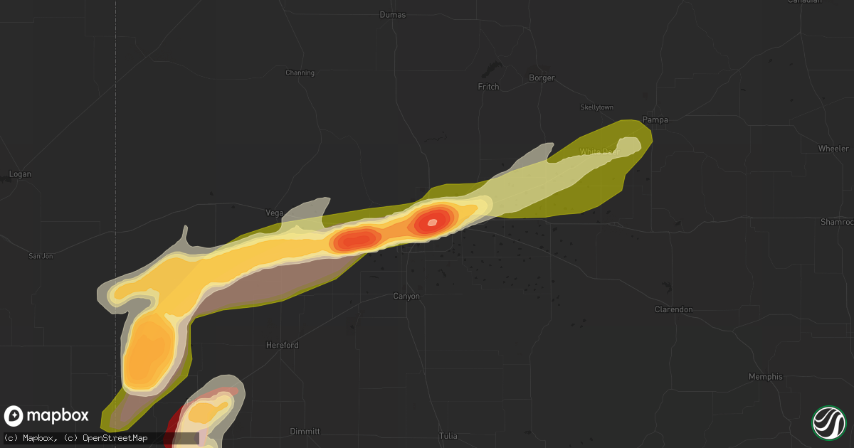
Hail Map in Amarillo, TX on May 28, 2013
Get this storm
May 28 map
$229
one time, instant access
Download today. No call, no setup
Keep the $229
Bought the map and want the full workflow? Apply the entire $229 to a subscription within 7 days. None of it is wasted.
Every map, not just this one
This buys you this map. Subscription and you get every map we run, in the markets you choose from a few cities to whole states to nationwide. Plus real-time alerts the moment a storm fires.
Contact data
Name, contact info, occupancy, even credit band for addresses in the footprint. You go from where it hit to who to call.
Become the source they trust
Unlimited branding weather history reports on demand. You already have the documented answer ready for the property owner, and you are the one who showed up with it.
Property data and RoofTrace estimates
Pull up any address you have got, its value and the exact code rules for that jurisdiction, straight from One Click Code. Then RoofTrace estimates the squares, pitch, and roof value, priced the way you price.
Storm reports in Amarillo, TX
Amarillo, TX
| Date | Description |
|---|---|
| 05/28/20136:13 PM CDT | A local report indicates 66 MPH wind near 7 ENE AMARILLO |
| 05/28/20136:11 PM CDT | A local report indicates 60 MPH wind near 5 W AMARILLO |
| 05/28/20136:09 PM CDT | A local report indicates 61 MPH wind near 5 NNW AMARILLO |
| 05/28/20136:06 PM CDT | A local report indicates 58 MPH wind near 7 SW PANTEX |
| 05/28/20136:05 PM CDT | A local report indicates 66 MPH wind near 7 ENE AMARILLO |
| 05/28/20136:05 PM CDT | A local report indicates 64 MPH wind near 2 W AMARILLO |
| 05/28/20136:02 PM CDT | A local report indicates 60 MPH wind near 7 ENE AMARILLO |
| 05/28/20135:57 PM CDT | Power lines down in the fairgrounds area. |
| 05/28/20135:57 PM CDT | A local report indicates 66 MPH wind near 5 SSW AMARILLO |
| 05/28/20135:57 PM CDT | Roof blown off a metal building at 6th and osage |
| 05/28/20135:44 PM CDT | A local report indicates 61 MPH wind near 3 NW AMARILLO |
| 05/28/20135:44 PM CDT | A local report indicates 58 MPH wind near 6 ENE AMARILLO |
| 05/28/20135:36 PM CDT | A local report indicates 58 MPH wind near 6 ENE AMARILLO |
| 05/28/20135:28 PM CDT | A local report indicates 58 MPH wind near 2 WSW AMARILLO |
| 05/28/20135:16 PM CDT | Two power poles snapped at washington street and farmers |
| 05/28/20135:00 PM CDT | A local report indicates 62 MPH wind near 7 ENE AMARILLO |
| 05/28/20135:00 PM CDT | Tree limbs blown off - most around three to four inches in diameter with some five to seven inch diameter limbs |
| 05/28/20134:59 PM CDT | A local report indicates 58 MPH wind near 6 W AMARILLO |
| 05/28/20134:57 PM CDT | A local report indicates 69 MPH wind near 5 WNW TIMBERCREEK CANYO |
| 05/28/20134:52 PM CDT | A local report indicates 60 MPH wind near 3 E BUSHLAND |
| 05/28/20134:46 PM CDT | A local report indicates 58 MPH wind near 6 ENE AMARILLO |
| 05/28/20134:33 PM CDT | A local report indicates 61 MPH wind near 5 SSW AMARILLO |
| 05/28/201312:30 AM CDT | Peas to half dollar size hail |
| 05/28/201312:15 AM CDT | Hail covering roadway. |
| 05/28/201312:14 AM CDT | Hail nearly the ground. |
| 05/28/201312:05 AM CDT | Pea to quarter size hail fell at the nws office. Hail was nearly covering the ground. |
| 05/28/201312:00 AM CDT | A local report indicates 1.75 inch wind near 4 NNW AMARILLO |
| 05/27/201311:52 PM CDT | 1.5 inches of hail covering ground. |
| 05/27/201311:50 PM CDT | A local report indicates 1.50 inch wind near 2 SW AMARILLO |
| 05/27/201311:47 PM CDT | A local report indicates 1.75 inch wind near 6 WSW AMARILLO |
| 05/27/201311:47 PM CDT | A local report indicates 1.00 inch wind near AMARILLO |
| 05/27/201311:41 PM CDT | A local report indicates 1.25 inch wind near AMARILLO |
| 05/27/201311:41 PM CDT | Large 2 to 3 foot diameter tree was split with the split part peeling down and southward facing windows and skylights were broken at an apartment complex. |
| 05/27/201311:40 PM CDT | Hail broke windows at a restaurant at 34th and soncy. |
| 05/27/201311:39 PM CDT | Golfball size hail at the loop and western |
| 05/27/201311:38 PM CDT | A local report indicates 1.25 inch wind near 7 WSW AMARILLO |
| 05/27/201311:38 PM CDT | Golfball size hail at i-40 and coulter |
| 05/27/201311:35 PM CDT | A local report indicates 1.75 inch wind near 4 WSW AMARILLO |
| 05/27/201311:11 PM CDT | Power flashes also reported at this location |
All States Impacted by Hail Map on May 28, 2013
All Cities Impacted by Hail Map on May 28, 2013
- Lewellen, NE
- Arthur, NE
- Kinsman, OH
- Jamestown, PA
- Williamsfield, OH
- Greenville, PA
- Atlantic, PA
- Adamsville, PA
- Hartstown, PA
- Andover, OH
- Hadley, PA
- Torrington, WY
- Amarillo, TX
- Wildorado, TX
- Tescott, KS
- Bennington, KS
- Minneapolis, KS
- Iliff, CO
- Crook, CO
- Plains, KS
- Forgan, OK
- Meade, KS
- Lingle, WY
- Ovid, CO
- Brownville, NE
- Rock Port, MO
- Tarkio, MO
- Westboro, MO
- Nemaha, NE
- Barnard, KS
- Friona, TX
- Seneca, KS
- Baileyville, KS
- Goff, KS
- Oneida, KS
- Sabetha, KS
- Corning, KS
- Centralia, KS
- Wetmore, KS
- Allerton, IA
- Corydon, IA
- Humeston, IA
- Sublette, KS
- Satanta, KS
- Julesburg, CO
- Victoria, KS
- Walker, KS
- Hereford, TX
- Vega, TX
- Ashland, KS
- Rosston, OK
- Buffalo, OK
- Protection, KS
- Auburn, NE
- Watson, MO
- Beloit, KS
- Lincoln, KS
- Solomon, KS
- Lucas, KS
- Tipton, KS
- Hunter, KS
- Beverly, KS
- Osborne, KS
- Lenox, IA
- Creston, IA
- Hiawatha, KS
- Highland, KS
- Robinson, KS
- Venango, NE
- Gurley, NE
- Sidney, NE
- Sedgwick, CO
- Chappell, NE
- Muleshoe, TX
- Farwell, TX
- Fleming, CO
- Newcastle, WY
- Vermillion, KS
- Axtell, KS
- Havensville, KS
- Frankfort, KS
- Home, KS
- Powhattan, KS
- Onaga, KS
- Beattie, KS
- Fairview, KS
- Hays, KS
- Schoenchen, KS
- Sterling, CO
- Chariton, IA
- Oshkosh, NE
- Tryon, NE
- Columbus Junction, IA
- Crawfordsville, IA
- Mount Pleasant, IA
- Wapello, IA
- Wayland, IA
- Winfield, IA
- Coldwater, KS
- Lodgepole, NE
- Panhandle, TX
- Adrian, TX
- Potter, NE
- Dalton, NE
- Harrison, NE
- Morrill, NE
- Circleville, KS
- Blue Rapids, KS
- Summerfield, KS
- Netawaka, KS
- Soldier, KS
- Marysville, KS
- Haxtun, CO
- Hershey, NE
- Sutherland, NE
- White Cloud, KS
- Clearfield, IA
- Diagonal, IA
- Brighton, IA
- Bovina, TX
- Pampa, TX
- San Jon, NM
- White Deer, TX
- Groom, TX
- Gate, OK
- Englewood, KS
- Albia, IA
- Eddyville, IA
- Ottumwa, IA
- Pattonsburg, MO
- Maysville, MO
- Weatherby, MO
- Afton, IA
- Parkston, SD
- Dimock, SD
- Lancaster, KS
- Wathena, KS
- Bendena, KS
- Denton, KS
- Oregon, MO
- Troy, KS
- Atchison, KS
- Everest, KS
- Pickering, MO
- Blockton, IA
- Sheridan, MO
- Hatfield, MO
- Redding, IA
- Grant City, MO
- Parnell, MO
- Maryville, MO
- Mount Ayr, IA
- Ravenwood, MO
- Hopkins, MO
- Paxton, NE
- Richland, IA
- Fairfield, IA
- Packwood, IA
- Hallam, NE
- Pickrell, NE
- Clatonia, NE
- Fairbury, NE
- Martell, NE
- Plymouth, NE
- Jansen, NE
- Cortland, NE
- De Witt, NE
- Diller, NE
- Beatrice, NE
- Endicott, NE
- Fort Laramie, WY
- Jay Em, WY
- Yoder, WY
- Wilmore, KS
- Ulysses, KS
- Grant, NE
- Kilgore, NE
- Dix, NE
- Padroni, CO
- Lemoyne, NE
- Peetz, CO
- Lisco, NE
- Lake City, KS
- Saint Joseph, MO
- Savannah, MO
- McFall, MO
- Rea, MO
- Amazonia, MO
- King City, MO
- Union Star, MO
- Cosby, MO
- Amity, MO
- Helena, MO
- Otis, CO
- Big Springs, NE
- Madrid, NE
- Ogallala, NE
- Holyoke, CO
- Kellerton, IA
- Eagleville, MO
- Lamoni, IA
- Mukwonago, WI
- Tripp, SD
- Delmont, SD
- Burlington Junction, MO
- Elmo, MO
- Skidmore, MO
- Clearmont, MO
- Chillicothe, MO
- Wheeling, MO
- Linneus, MO
- Purdin, MO
- Laverne, OK
- Alva, OK
- Freedom, OK
- Deer Trail, CO
- Agate, CO
- Keystone, NE
- Bristolville, OH
- Southington, OH
- Warren, OH
- Farmdale, OH
- Cortland, OH
- West Farmington, OH
- Cochranton, PA
- Orwell, OH
- Rome, OH
- Jefferson, OH
- West Springfield, PA
- Albion, PA
- Conneaut, OH
- Accokeek, MD
- Clinton, MD
- Brandywine, MD
- Upper Marlboro, MD
- Texico, NM
- Skellytown, TX
- Gruver, TX
- Spearman, TX
- Stratford, TX
- Fowler, KS
- Horton, KS
- McCracken, KS
- Agenda, KS
- Haddam, KS
- Clifton, KS
- Mahaska, KS
- Concordia, KS
- Washington, KS
- Morrowville, KS
- Clyde, KS
- Wilber, NE
- Downs, KS
- Glen Elder, KS
- Hemingford, NE
- Alliance, NE
- McCamey, TX
- Crane, TX
- Eagle, WI
- Lovilia, IA
- Cedar, IA
- Oskaloosa, IA
- Hedrick, IA
- Fremont, IA
- Sigourney, IA
- Bedford, IA
- Osceola, IA
- Weldon, IA
- Woodburn, IA
- Grand River, IA
- Blakesburg, IA
- Promise City, IA
- Russell, IA
- Lockridge, IA
- Keithsburg, IL
- Oakville, IA
- Mediapolis, IA
- Seaton, IL
- Washington, IA


