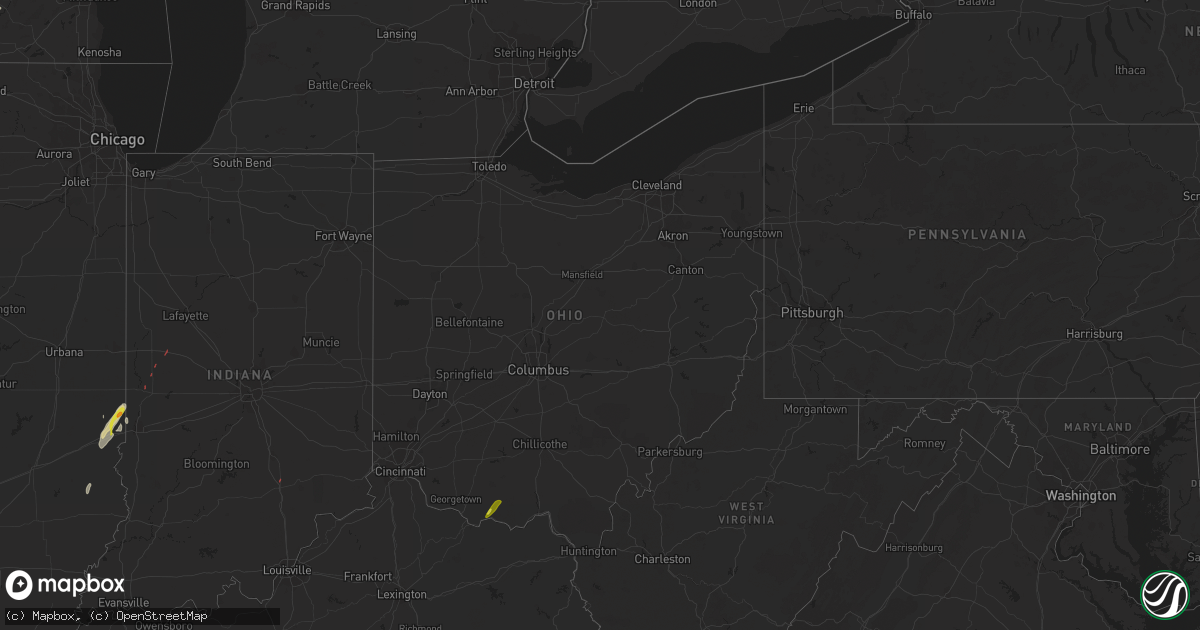
Hail Map in Ohio on May 26, 2022
Get this storm
May 26 map
$229
one time, instant access
Download today. No call, no setup
Keep the $229
Bought the map and want the full workflow? Apply the entire $229 to a subscription within 7 days. None of it is wasted.
Every map, not just this one
This buys you this map. Subscription and you get every map we run, in the markets you choose from a few cities to whole states to nationwide. Plus real-time alerts the moment a storm fires.
Contact data
Name, contact info, occupancy, even credit band for addresses in the footprint. You go from where it hit to who to call.
Become the source they trust
Unlimited branding weather history reports on demand. You already have the documented answer ready for the property owner, and you are the one who showed up with it.
Property data and RoofTrace estimates
Pull up any address you have got, its value and the exact code rules for that jurisdiction, straight from One Click Code. Then RoofTrace estimates the squares, pitch, and roof value, priced the way you price.
Storm reports in Ohio
Ohio
| Date | Description |
|---|---|
| 05/26/20226:37 PM CDT | Report of twisted trees along eastern avenue near us-23. Time estimated from radar. |
| 05/26/20226:28 PM CDT | Emergency manager reports about 75 trees blow down. Time estimated by radar. |
| 05/26/20226:25 PM CDT | Trees down through the area |
| 05/26/20226:25 PM CDT | Trees down |
| 05/26/20225:35 PM CDT | Several trees downed in the lynx area. Time estimated by radar. |
| 05/26/20221:10 PM CDT | Tree in roadway hine rd and sr128 - time estimated |
| 05/26/202212:55 PM CDT | Tree down. Photo posted on social media. |
| 05/26/20222:59 AM CDT | At 759 PM EDT, a severe thunderstorm was located 8 miles east of Kingston, moving northeast at 45 mph. HAZARD...60 mph wind gusts. SOURCE...Radar indicated. IMPACT...Expect damage to trees and power lines. Locations impacted include... Lancaster, Baltimore, Buckeye Lake, Bremen, Millersport, Pleasantville, Hide-A-Way Hills, Fairfield Beach, Amanda, Thurston, Stoutsville, Laurelville, Sugar Grove, Adelphi, Rushville, Tarlton, West Rushville, Fairfield County Airport, US Route 22 at State Route 159 and Clearport. |
| 05/26/20221:58 AM CDT | At 657 PM EDT, a severe thunderstorm was located 7 miles east of Peebles, moving northeast at 40 mph. HAZARD...60 mph wind gusts and penny size hail. SOURCE...Radar indicated. IMPACT...Expect damage to trees and power lines. Locations impacted include... Chillicothe, Waverly, Piketon, Pike Lake, Kincaid Springs, Rarden, Bourneville, Poplar Grove, Pike County Airport, Elm Grove, Omega, Buchanan, Summithill, Knockemstiff, Ladd, Mount Joy, Massieville, Lake White, Scioto Trail State Park and Idaho. |
| 05/26/20221:27 AM CDT | At 626 PM EDT, a severe thunderstorm was located over West Union, moving northeast at 30 mph. HAZARD...60 mph wind gusts. SOURCE...Radar indicated. IMPACT...Expect damage to trees and power lines. Locations impacted include... Blue Creek, State Route 348 at State Route 125, Cedar Mills and Dunkinsville. |
| 05/26/20221:19 AM CDT | At 619 PM EDT, a severe thunderstorm was located near Peebles, moving northeast at 25 mph. HAZARD...60 mph wind gusts. SOURCE...Radar indicated. IMPACT...Expect damage to trees and power lines. Locations impacted include... Peebles, Rarden, Poplar Grove, Ladd, Mount Joy, Elm Grove, Smoky Corners and Locust Grove. |
| 05/26/202212:20 AM CDT | At 520 PM EDT, a severe thunderstorm was located over Fairview, moving northeast at 30 mph. HAZARD...60 mph wind gusts. SOURCE...Radar indicated. IMPACT...Expect damage to trees and power lines. Locations impacted include... Maysville, Washington, Lewisburg, Mount Olivet, Sardis, US Route 62 at State Route 875, Blue Licks Battlefield, Abigail, Murphysville, Moranburg, Burika, Mount Gilead, Alhambra, Mays Lick, Mitchells Mill, Rectorville, Peed, Fleming-Mason Airport, Lowell and Orangeburg. |
| 05/25/20229:04 PM CDT | At 204 PM EDT, a severe thunderstorm was located near Ross, moving northeast at 35 mph. HAZARD...60 mph wind gusts. SOURCE...Radar indicated. IMPACT...Expect damage to trees and power lines. Locations impacted include... Hamilton, Middletown, Fairfield, Miamisburg, Springboro, Monroe, Trenton, Franklin, Carlisle, South Middletown, Gratis, Seven Mile, Williamsdale, Hunter, Darrtown, Germantown, New Miami, Farmersville, Millville and Somerville.This includes I-75 in Ohio between mile markers 27 and 41. |
| 05/25/20228:03 PM CDT | At 103 PM EDT, a severe thunderstorm was located 9 miles north of Vevay, moving northeast at 35 mph. HAZARD...60 mph wind gusts. SOURCE...Radar indicated. IMPACT...Expect damage to trees and power lines. Locations impacted include... Florence, Lawrenceburg, Greendale, Aurora, Rising Sun, Oakbrook, Burlington, Union, Vevay, Dillsboro, Shawnee, Wilmington, French, Hartford, Fairview, Ghent, Center Square, Aberdeen, Idlewild and Waterloo.This includes I-75 in Kentucky between mile markers 179 and 181. |
| 05/25/20227:26 PM CDT | 6 trees down in berne township - time estimated |
All States Impacted by Hail Map on May 26, 2022
Cities Impacted by Hail Map on May 26, 2022
- Bessemer City, NC
- Dallas, NC
- Lincolnton, NC
- Newton, NC
- Fort Atkinson, WI
- Marshall, WI
- Shelby, NC
- Lawndale, NC
- Jefferson, WI
- Johnson Creek, WI
- Hickory, NC
- Granite Falls, NC
- Connelly Springs, NC
- Hildebran, NC
- Taylorsville, NC
- Havana, IL
- Kilbourne, IL
- Oconomowoc, WI
- Watertown, WI
- Sullivan, WI
- Ixonia, WI
- Helenville, WI
- Adrian, GA
- Stanley, NC
- Iron Station, NC
- Alexis, NC
- Maiden, NC
- Vale, NC
- Janesville, WI
- Oblong, IL
- Willow Hill, IL
- Statesville, NC
- Stony Point, NC
- West Union, OH
- Manchester, OH
- Fox Lake, WI
- Beaver Dam, WI
- Hiddenite, NC
- Berwick, IL
- Avon, IL
- Roseville, IL
- Alexis, IL
- Gerlaw, IL
- Monmouth, IL
- Good Hope, IL
- Cameron, IL
- Paris, IL
- Gaffney, SC
- Blacksburg, SC
- Clinton, IN
- Martinsville, IL
- Marshall, IL
- Dennison, IL
- Vermilion, IL
- Catawba, NC
- Eldridge, IA
- Kings Mountain, NC
- Gastonia, NC
- Milton, WI
- West Terre Haute, IN
- Manito, IL
- Forest City, IL
- Topeka, IL
- Davenport, IA
- Chandlerville, IL
- Oakford, IL
- Liverpool, IL
- Lewistown, IL
- Cambridge, WI
- Edgerton, WI
- Grover, NC
- Conover, NC
- Claremont, NC
- Griggsville, IL
- Stoughton, WI
- Ashland, IL
- Lynchburg, VA
- Forest, VA
- Bedford, VA
- Goode, VA
- Moravian Falls, NC
- Wilkesboro, NC
- Roaring River, NC
- North Wilkesboro, NC
- Harmony, NC
- Ararat, VA
- Union Grove, NC
- Ararat, NC
- Hamptonville, NC
- Jonesville, NC
- Mount Airy, NC
- Dobson, NC
- Claudville, VA
- Boonville, NC
- Olin, NC
- Yadkinville, NC
- Elkin, NC
- Pilot Mountain, NC
- Tobaccoville, NC
- Pinnacle, NC
- Stuart, VA
- Lawsonville, NC
- Westfield, NC
- Spencer, VA
- Critz, VA
- Danbury, NC
- King, NC
- East Bend, NC
- Siloam, NC
- Clemmons, NC
- Winston Salem, NC
- Rural Hall, NC
- Lewisville, NC
- Pfafftown, NC
- Walnut Cove, NC
- Germanton, NC
- Pineville, KY
- Middlesboro, KY
- Seymour, IN
- Bloomingdale, IN
- Montezuma, IN
- Kingman, IN
- Waynetown, IN
- Shannon, IL
- Blue Creek, OH
- Peebles, OH
- Jewell, GA
- Norwood, GA
- Warrenton, GA
- Tennille, GA
- Sparta, GA
- Sandersville, GA
- Warthen, GA
- Mitchell, GA


