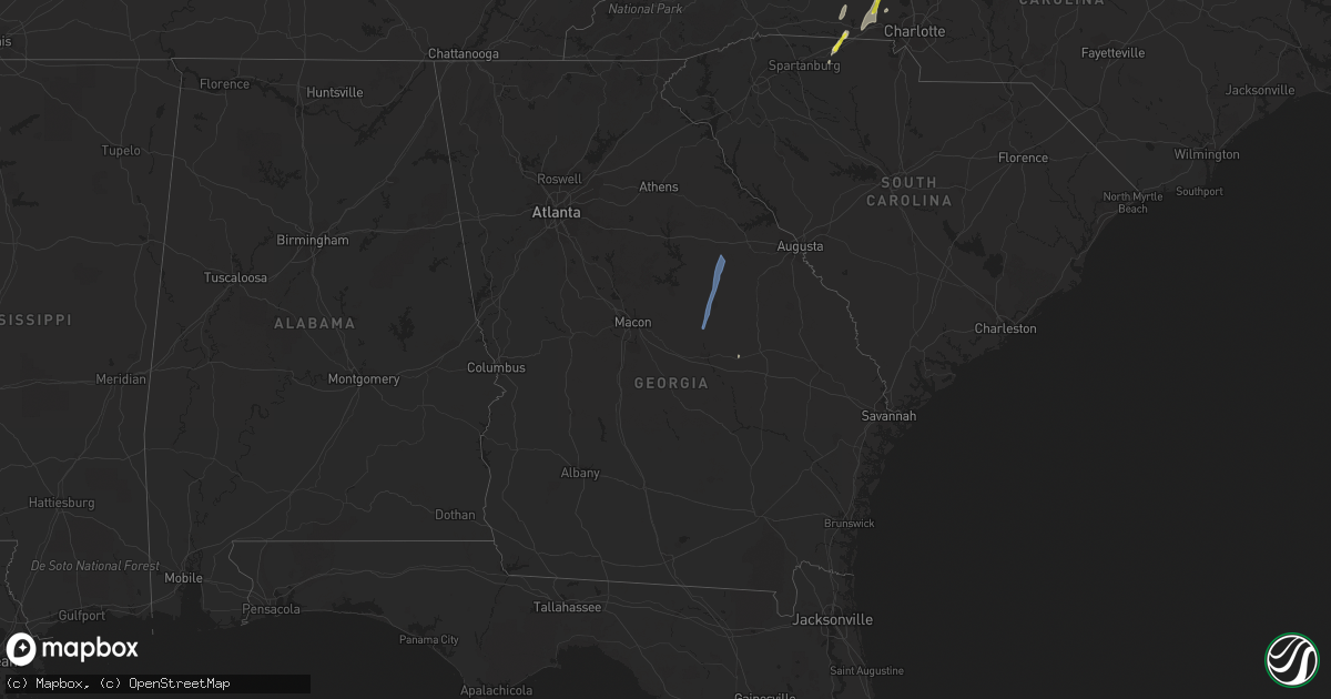
Hail Map in Georgia on May 26, 2022
Get this storm
May 26 map
$229
one time, instant access
Download today. No call, no setup
Keep the $229
Bought the map and want the full workflow? Apply the entire $229 to a subscription within 7 days. None of it is wasted.
Every map, not just this one
This buys you this map. Subscription and you get every map we run, in the markets you choose from a few cities to whole states to nationwide. Plus real-time alerts the moment a storm fires.
Contact data
Name, contact info, occupancy, even credit band for addresses in the footprint. You go from where it hit to who to call.
Become the source they trust
Unlimited branding weather history reports on demand. You already have the documented answer ready for the property owner, and you are the one who showed up with it.
Property data and RoofTrace estimates
Pull up any address you have got, its value and the exact code rules for that jurisdiction, straight from One Click Code. Then RoofTrace estimates the squares, pitch, and roof value, priced the way you price.
Storm reports in Georgia
Georgia
| Date | Description |
|---|---|
| 05/26/20222:15 PM CDT | Ema report of trees and powerlines down near the intersection of hwy 68 and 272. |
| 05/25/202210:52 PM CDT | At 351 PM EDT, a severe thunderstorm was located over Hamburg State Park, or 9 miles west of Gibson, moving northeast at 45 mph. HAZARD...60 mph wind gusts. SOURCE...Emergency management. IMPACT...Expect damage to roofs, siding, and trees. Locations impacted include... Warrenton, Gibson, Norwood, Mitchell, Camak, Edge Hill, Edgehill, Hamburg State Park, Shoals, Downs, Jewell, Warthen, Beall Springs, Mayfield, Agricola, Reese and Bastonville. |
| 05/25/202210:25 PM CDT | At 325 PM EDT, a severe thunderstorm was located near Tennille, or near Sandersville, moving northeast at 45 mph. HAZARD...60 mph wind gusts. SOURCE...Radar indicated. IMPACT...Expect damage to roofs, siding, and trees. Locations impacted include... Sandersville, Tennille, Oconee, Deepstep, Hamburg State Park, Downs, Warthen and Hebron. |
| 05/25/202210:07 PM CDT | At 307 PM EDT, a severe thunderstorm was located near Chappells Mill, or 10 miles southeast of Irwinton, moving north at 35 mph. HAZARD...60 mph wind gusts. SOURCE...Radar indicated. IMPACT...Expect damage to roofs, siding, and trees. Locations impacted include... Irwinton, Toomsboro, Oconee, Chappells Mill, Tuckers Crossroad and Nicklesville. |
All States Impacted by Hail Map on May 26, 2022
Cities Impacted by Hail Map on May 26, 2022
- Bessemer City, NC
- Dallas, NC
- Lincolnton, NC
- Newton, NC
- Fort Atkinson, WI
- Marshall, WI
- Shelby, NC
- Lawndale, NC
- Jefferson, WI
- Johnson Creek, WI
- Hickory, NC
- Granite Falls, NC
- Connelly Springs, NC
- Hildebran, NC
- Taylorsville, NC
- Havana, IL
- Kilbourne, IL
- Oconomowoc, WI
- Watertown, WI
- Sullivan, WI
- Ixonia, WI
- Helenville, WI
- Adrian, GA
- Stanley, NC
- Iron Station, NC
- Alexis, NC
- Maiden, NC
- Vale, NC
- Janesville, WI
- Oblong, IL
- Willow Hill, IL
- Statesville, NC
- Stony Point, NC
- West Union, OH
- Manchester, OH
- Fox Lake, WI
- Beaver Dam, WI
- Hiddenite, NC
- Berwick, IL
- Avon, IL
- Roseville, IL
- Alexis, IL
- Gerlaw, IL
- Monmouth, IL
- Good Hope, IL
- Cameron, IL
- Paris, IL
- Gaffney, SC
- Blacksburg, SC
- Clinton, IN
- Martinsville, IL
- Marshall, IL
- Dennison, IL
- Vermilion, IL
- Catawba, NC
- Eldridge, IA
- Kings Mountain, NC
- Gastonia, NC
- Milton, WI
- West Terre Haute, IN
- Manito, IL
- Forest City, IL
- Topeka, IL
- Davenport, IA
- Chandlerville, IL
- Oakford, IL
- Liverpool, IL
- Lewistown, IL
- Cambridge, WI
- Edgerton, WI
- Grover, NC
- Conover, NC
- Claremont, NC
- Griggsville, IL
- Stoughton, WI
- Ashland, IL
- Lynchburg, VA
- Forest, VA
- Bedford, VA
- Goode, VA
- Moravian Falls, NC
- Wilkesboro, NC
- Roaring River, NC
- North Wilkesboro, NC
- Harmony, NC
- Ararat, VA
- Union Grove, NC
- Ararat, NC
- Hamptonville, NC
- Jonesville, NC
- Mount Airy, NC
- Dobson, NC
- Claudville, VA
- Boonville, NC
- Olin, NC
- Yadkinville, NC
- Elkin, NC
- Pilot Mountain, NC
- Tobaccoville, NC
- Pinnacle, NC
- Stuart, VA
- Lawsonville, NC
- Westfield, NC
- Spencer, VA
- Critz, VA
- Danbury, NC
- King, NC
- East Bend, NC
- Siloam, NC
- Clemmons, NC
- Winston Salem, NC
- Rural Hall, NC
- Lewisville, NC
- Pfafftown, NC
- Walnut Cove, NC
- Germanton, NC
- Pineville, KY
- Middlesboro, KY
- Seymour, IN
- Bloomingdale, IN
- Montezuma, IN
- Kingman, IN
- Waynetown, IN
- Shannon, IL
- Blue Creek, OH
- Peebles, OH
- Jewell, GA
- Norwood, GA
- Warrenton, GA
- Tennille, GA
- Sparta, GA
- Sandersville, GA
- Warthen, GA
- Mitchell, GA


