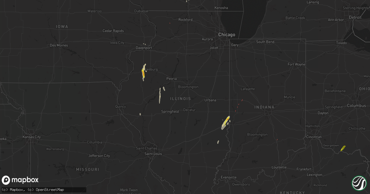
Hail Map in Illinois on May 26, 2022
Get this storm
May 26 map
$229
one time, instant access
Download today. No call, no setup
Keep the $229
Bought the map and want the full workflow? Apply the entire $229 to a subscription within 7 days. None of it is wasted.
Every map, not just this one
This buys you this map. Subscription and you get every map we run, in the markets you choose from a few cities to whole states to nationwide. Plus real-time alerts the moment a storm fires.
Contact data
Name, contact info, occupancy, even credit band for addresses in the footprint. You go from where it hit to who to call.
Become the source they trust
Unlimited branding weather history reports on demand. You already have the documented answer ready for the property owner, and you are the one who showed up with it.
Property data and RoofTrace estimates
Pull up any address you have got, its value and the exact code rules for that jurisdiction, straight from One Click Code. Then RoofTrace estimates the squares, pitch, and roof value, priced the way you price.
Storm reports in Illinois
Illinois
| Date | Description |
|---|---|
| 05/26/20222:47 PM CDT | Report from mping: quarter |
| 05/26/20222:47 PM CDT | Report from mping: 3-inch tree limbs broken; power poles broken. |
| 05/26/20222:20 PM CDT | Delayed confirmation from earlier this afternoon of a 30 second duration tornado based on multiple spotter reports of rotating dust underneath a funnel northwest of for |
| 05/26/20222:15 PM CDT | Large fully leafed tree limb snapped. Time estimated from radar. |
| 05/26/20221:33 PM CDT | Tree down over road near andover. |
| 05/26/202212:16 PM CDT | Dime to quarter size hail and torrential rain in monmouth. |
| 05/26/20227:34 AM CDT | At 1234 PM CDT, a severe thunderstorm was located over Gerlaw, or 7 miles northeast of Monmouth, moving north at 25 mph. HAZARD...60 mph wind gusts and quarter size hail. SOURCE...Radar indicated. IMPACT...Hail damage to vehicles is expected. Expect wind damage to roofs, siding, and trees. This severe thunderstorm will be near... North Henderson and Alexis around 1245 PM CDT.Other locations in the path of this severe thunderstorm includeBurgess, Sunbeam, Viola, Shale City, Gilchrist, Wanlock, Griffin,Mercer County Fairgrounds, Aledo, Old Gilchrist, Matherville,Sherrard, Reynolds, Boden, Cable, Hamlet, Preemption, Gingle Cornersand Aledo Mercer County Airport. |
| 05/26/20226:41 AM CDT | At 1140 AM CDT, a severe thunderstorm was located near Berwick, or 10 miles south of Monmouth, moving north at 30 mph. HAZARD...60 mph wind gusts and quarter size hail. SOURCE...Radar indicated. IMPACT...Hail damage to vehicles is expected. Expect wind damage to roofs, siding, and trees. This severe thunderstorm will be near... Ormonde, Larchland and Ponemah around 1150 AM CDT. Cameron around 1155 AM CDT. Kirkwood around 1200 PM CDT.Other locations in the path of this severe thunderstorm includeMonmouth, Coldbrook, Monmouth Municipal Airport, Gerlaw, Eleanor,Little York, Lake Warren and Alexis. |
| 05/26/20225:43 AM CDT | At 1043 AM CDT, a severe thunderstorm was located near Tallula, or 11 miles east of Virginia, moving north at 30 mph. HAZARD...60 mph wind gusts and quarter size hail. SOURCE...Radar indicated. IMPACT...Hail damage to vehicles is expected. Expect wind damage to roofs, siding, and trees. Locations impacted include... Kilbourne and Havana. |
All States Impacted by Hail Map on May 26, 2022
Cities Impacted by Hail Map on May 26, 2022
- Bessemer City, NC
- Dallas, NC
- Lincolnton, NC
- Newton, NC
- Fort Atkinson, WI
- Marshall, WI
- Shelby, NC
- Lawndale, NC
- Jefferson, WI
- Johnson Creek, WI
- Hickory, NC
- Granite Falls, NC
- Connelly Springs, NC
- Hildebran, NC
- Taylorsville, NC
- Havana, IL
- Kilbourne, IL
- Oconomowoc, WI
- Watertown, WI
- Sullivan, WI
- Ixonia, WI
- Helenville, WI
- Adrian, GA
- Stanley, NC
- Iron Station, NC
- Alexis, NC
- Maiden, NC
- Vale, NC
- Janesville, WI
- Oblong, IL
- Willow Hill, IL
- Statesville, NC
- Stony Point, NC
- West Union, OH
- Manchester, OH
- Fox Lake, WI
- Beaver Dam, WI
- Hiddenite, NC
- Berwick, IL
- Avon, IL
- Roseville, IL
- Alexis, IL
- Gerlaw, IL
- Monmouth, IL
- Good Hope, IL
- Cameron, IL
- Paris, IL
- Gaffney, SC
- Blacksburg, SC
- Clinton, IN
- Martinsville, IL
- Marshall, IL
- Dennison, IL
- Vermilion, IL
- Catawba, NC
- Eldridge, IA
- Kings Mountain, NC
- Gastonia, NC
- Milton, WI
- West Terre Haute, IN
- Manito, IL
- Forest City, IL
- Topeka, IL
- Davenport, IA
- Chandlerville, IL
- Oakford, IL
- Liverpool, IL
- Lewistown, IL
- Cambridge, WI
- Edgerton, WI
- Grover, NC
- Conover, NC
- Claremont, NC
- Griggsville, IL
- Stoughton, WI
- Ashland, IL
- Lynchburg, VA
- Forest, VA
- Bedford, VA
- Goode, VA
- Moravian Falls, NC
- Wilkesboro, NC
- Roaring River, NC
- North Wilkesboro, NC
- Harmony, NC
- Ararat, VA
- Union Grove, NC
- Ararat, NC
- Hamptonville, NC
- Jonesville, NC
- Mount Airy, NC
- Dobson, NC
- Claudville, VA
- Boonville, NC
- Olin, NC
- Yadkinville, NC
- Elkin, NC
- Pilot Mountain, NC
- Tobaccoville, NC
- Pinnacle, NC
- Stuart, VA
- Lawsonville, NC
- Westfield, NC
- Spencer, VA
- Critz, VA
- Danbury, NC
- King, NC
- East Bend, NC
- Siloam, NC
- Clemmons, NC
- Winston Salem, NC
- Rural Hall, NC
- Lewisville, NC
- Pfafftown, NC
- Walnut Cove, NC
- Germanton, NC
- Pineville, KY
- Middlesboro, KY
- Seymour, IN
- Bloomingdale, IN
- Montezuma, IN
- Kingman, IN
- Waynetown, IN
- Shannon, IL
- Blue Creek, OH
- Peebles, OH
- Jewell, GA
- Norwood, GA
- Warrenton, GA
- Tennille, GA
- Sparta, GA
- Sandersville, GA
- Warthen, GA
- Mitchell, GA


