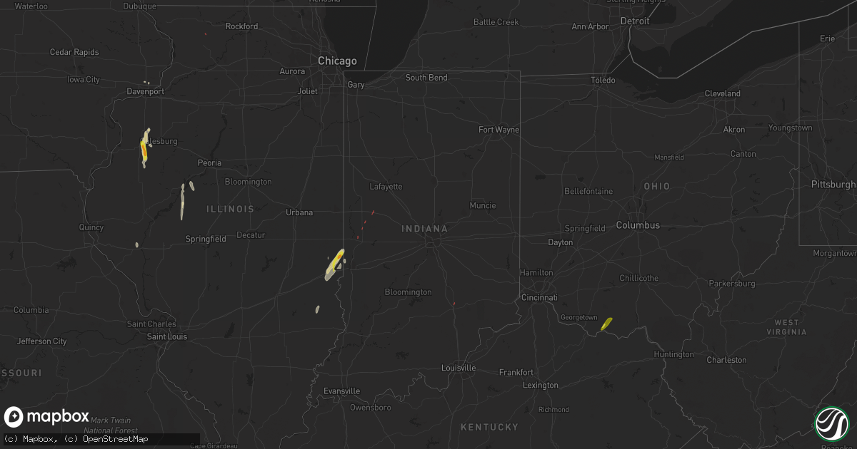
Hail Map in Indiana on May 26, 2022
Get this storm
May 26 map
$229
one time, instant access
Download today. No call, no setup
Keep the $229
Bought the map and want the full workflow? Apply the entire $229 to a subscription within 7 days. None of it is wasted.
Every map, not just this one
This buys you this map. Subscription and you get every map we run, in the markets you choose from a few cities to whole states to nationwide. Plus real-time alerts the moment a storm fires.
Contact data
Name, contact info, occupancy, even credit band for addresses in the footprint. You go from where it hit to who to call.
Become the source they trust
Unlimited branding weather history reports on demand. You already have the documented answer ready for the property owner, and you are the one who showed up with it.
Property data and RoofTrace estimates
Pull up any address you have got, its value and the exact code rules for that jurisdiction, straight from One Click Code. Then RoofTrace estimates the squares, pitch, and roof value, priced the way you price.
Storm reports in Indiana
Indiana
| Date | Description |
|---|---|
| 05/26/20226:33 PM CDT | Reported tornado on the ground by law enforcement at the intersection of state road 25 and i-74. |
| 05/26/20226:33 PM CDT | Corrects previous tornado report from 1 n waynetown. Reported tornado on the ground by law enforcement was to the ne of the hwy 25 and i-74 intersection. No damage foun |
| 05/26/20223:29 AM CDT | At 828 PM EDT, a severe thunderstorm was located near West Lafayette, or near Lafayette, moving northeast at 20 mph. HAZARD...60 mph wind gusts. SOURCE...Radar indicated. IMPACT...Expect damage to roofs, siding, and trees. This severe thunderstorm will be near... Purdue University around 840 PM EDT. Lafayette and West Lafayette around 845 PM EDT.Other locations in the path of this severe thunderstorm includeBattle Ground.This includes Interstate 65 between mile markers 174 and 184. |
| 05/26/20223:26 AM CDT | At 826 PM EDT, a severe thunderstorm was located 7 miles south of Crawfordsville, moving north at 25 mph. HAZARD...60 mph wind gusts. SOURCE...Radar indicated. IMPACT...Expect damage to roofs, siding, and trees. Locations impacted include... Crawfordsville and Darlington.This includes Interstate 74 between mile markers 26 and 42. |
| 05/26/20223:03 AM CDT | At 803 PM EDT, a severe thunderstorm was located 12 miles southwest of Lafayette, moving northeast at 20 mph. HAZARD...70 mph wind gusts and penny size hail. SOURCE...Radar indicated. IMPACT...Expect considerable tree damage. Damage is likely to mobile homes, roofs, and outbuildings. Locations impacted include... Lafayette, West Lafayette and Shadeland. |
| 05/26/20222:22 AM CDT | At 722 PM EDT, severe thunderstorms were located along a line extending from 7 miles east of Brazil to near Spencer, moving north at 30 mph. HAZARD...60 mph wind gusts and penny size hail. SOURCE...Radar indicated. IMPACT...Expect damage to roofs, siding, and trees. Severe thunderstorms will be near... Cagles Mill Lake and Reelsville around 730 PM EDT. Devore and Lena around 735 PM EDT. Cloverdale around 740 PM EDT.Other locations in the path of these severe thunderstorms includeGreencastle.This includes Interstate 70 between mile markers 26 and 46. |
| 05/26/20222:06 AM CDT | At 705 PM EDT/605 PM CDT/, a severe thunderstorm was located 14 miles southwest of English, moving northeast at 35 mph. HAZARD...60 mph wind gusts. SOURCE...Radar indicated. IMPACT...Expect damage to roofs, siding, and trees. Locations impacted include... English. |
| 05/26/20221:54 AM CDT | At 654 PM EDT, a severe thunderstorm was located 16 miles north of Linton, or 21 miles southeast of Terre Haute, moving north at 40 mph. HAZARD...60 mph wind gusts and nickel size hail. SOURCE...Radar indicated. IMPACT...Expect damage to roofs, siding, and trees. This severe thunderstorm will be near... Patricksburg around 700 PM EDT. Saline City around 705 PM EDT. Center Point and Bowling Green around 710 PM EDT.Other locations in the path of this severe thunderstorm includeKnightsville, Cagles Mill Lake and Harmony.This includes Interstate 70 between mile markers 22 and 29. |
| 05/26/20221:03 AM CDT | At 603 PM EDT, a severe thunderstorm was located over Clinton, or 16 miles north of Terre Haute, moving northeast at 25 mph. HAZARD...70 mph wind gusts. SOURCE...Radar indicated. IMPACT...Expect considerable tree damage. Damage is likely to mobile homes, roofs, and outbuildings. This severe thunderstorm will be near... Mecca around 615 PM EDT. Montezuma around 620 PM EDT.Other locations in the path of this severe thunderstorm includeBloomingdale. |
| 05/25/202211:10 PM CDT | At 409 PM EDT, a severe thunderstorm was located near Vermilion, or near Paris, moving northeast at 35 mph. HAZARD...60 mph wind gusts and quarter size hail. SOURCE...Public. IMPACT...Hail damage to vehicles is expected. Expect wind damage to roofs, siding, and trees. This severe thunderstorm will be near... Fairview Park around 420 PM EDT.Other locations in the path of this severe thunderstorm include Danaand Montezuma. |
| 05/25/20229:43 PM CDT | At 243 PM CDT, a severe thunderstorm was located near Marshall, moving north at 30 mph. HAZARD...60 mph wind gusts and quarter size hail. SOURCE...Radar indicated. IMPACT...Hail damage to vehicles is expected. Expect wind damage to roofs, siding, and trees. This severe thunderstorm will be near... Marshall and Clarksville around 255 PM CDT. Oliver and Dennison around 300 PM CDT.Other locations in the path of this severe thunderstorm includeVermilion, Paris and Chrisman.This includes Interstate 70 between mile markers 138 and 154. |
| 05/25/20229:22 PM CDT | Multiple trees down in mallard run subdivision. |
All States Impacted by Hail Map on May 26, 2022
Cities Impacted by Hail Map on May 26, 2022
- Bessemer City, NC
- Dallas, NC
- Lincolnton, NC
- Newton, NC
- Fort Atkinson, WI
- Marshall, WI
- Shelby, NC
- Lawndale, NC
- Jefferson, WI
- Johnson Creek, WI
- Hickory, NC
- Granite Falls, NC
- Connelly Springs, NC
- Hildebran, NC
- Taylorsville, NC
- Havana, IL
- Kilbourne, IL
- Oconomowoc, WI
- Watertown, WI
- Sullivan, WI
- Ixonia, WI
- Helenville, WI
- Adrian, GA
- Stanley, NC
- Iron Station, NC
- Alexis, NC
- Maiden, NC
- Vale, NC
- Janesville, WI
- Oblong, IL
- Willow Hill, IL
- Statesville, NC
- Stony Point, NC
- West Union, OH
- Manchester, OH
- Fox Lake, WI
- Beaver Dam, WI
- Hiddenite, NC
- Berwick, IL
- Avon, IL
- Roseville, IL
- Alexis, IL
- Gerlaw, IL
- Monmouth, IL
- Good Hope, IL
- Cameron, IL
- Paris, IL
- Gaffney, SC
- Blacksburg, SC
- Clinton, IN
- Martinsville, IL
- Marshall, IL
- Dennison, IL
- Vermilion, IL
- Catawba, NC
- Eldridge, IA
- Kings Mountain, NC
- Gastonia, NC
- Milton, WI
- West Terre Haute, IN
- Manito, IL
- Forest City, IL
- Topeka, IL
- Davenport, IA
- Chandlerville, IL
- Oakford, IL
- Liverpool, IL
- Lewistown, IL
- Cambridge, WI
- Edgerton, WI
- Grover, NC
- Conover, NC
- Claremont, NC
- Griggsville, IL
- Stoughton, WI
- Ashland, IL
- Lynchburg, VA
- Forest, VA
- Bedford, VA
- Goode, VA
- Moravian Falls, NC
- Wilkesboro, NC
- Roaring River, NC
- North Wilkesboro, NC
- Harmony, NC
- Ararat, VA
- Union Grove, NC
- Ararat, NC
- Hamptonville, NC
- Jonesville, NC
- Mount Airy, NC
- Dobson, NC
- Claudville, VA
- Boonville, NC
- Olin, NC
- Yadkinville, NC
- Elkin, NC
- Pilot Mountain, NC
- Tobaccoville, NC
- Pinnacle, NC
- Stuart, VA
- Lawsonville, NC
- Westfield, NC
- Spencer, VA
- Critz, VA
- Danbury, NC
- King, NC
- East Bend, NC
- Siloam, NC
- Clemmons, NC
- Winston Salem, NC
- Rural Hall, NC
- Lewisville, NC
- Pfafftown, NC
- Walnut Cove, NC
- Germanton, NC
- Pineville, KY
- Middlesboro, KY
- Seymour, IN
- Bloomingdale, IN
- Montezuma, IN
- Kingman, IN
- Waynetown, IN
- Shannon, IL
- Blue Creek, OH
- Peebles, OH
- Jewell, GA
- Norwood, GA
- Warrenton, GA
- Tennille, GA
- Sparta, GA
- Sandersville, GA
- Warthen, GA
- Mitchell, GA


