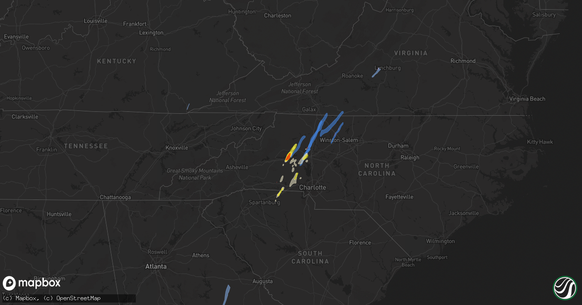
Hail Map on May 26, 2022
Get this storm
May 26 map
$229
one time, instant access
Download today. No call, no setup
Keep the $229
Bought the map and want the full workflow? Apply the entire $229 to a subscription within 7 days. None of it is wasted.
Every map, not just this one
This buys you this map. Subscription and you get every map we run, in the markets you choose from a few cities to whole states to nationwide. Plus real-time alerts the moment a storm fires.
Contact data
Name, contact info, occupancy, even credit band for addresses in the footprint. You go from where it hit to who to call.
Become the source they trust
Unlimited branding weather history reports on demand. You already have the documented answer ready for the property owner, and you are the one who showed up with it.
Property data and RoofTrace estimates
Pull up any address you have got, its value and the exact code rules for that jurisdiction, straight from One Click Code. Then RoofTrace estimates the squares, pitch, and roof value, priced the way you price.
States Impacted by Hail Map on May 26, 2022
Storm reports
Ohio
| Date | Description |
|---|---|
| 05/26/20226:37 PM CDT | Report of twisted trees along eastern avenue near us-23. Time estimated from radar. |
| 05/26/20226:28 PM CDT | Emergency manager reports about 75 trees blow down. Time estimated by radar. |
| 05/26/20226:25 PM CDT | Trees down through the area |
| 05/26/20226:25 PM CDT | Trees down |
| 05/26/20225:35 PM CDT | Several trees downed in the lynx area. Time estimated by radar. |
| 05/26/20221:10 PM CDT | Tree in roadway hine rd and sr128 - time estimated |
| 05/26/202212:55 PM CDT | Tree down. Photo posted on social media. |
| 05/26/20222:59 AM CDT | At 759 PM EDT, a severe thunderstorm was located 8 miles east of Kingston, moving northeast at 45 mph. HAZARD...60 mph wind gusts. SOURCE...Radar indicated. IMPACT...Expect damage to trees and power lines. Locations impacted include... Lancaster, Baltimore, Buckeye Lake, Bremen, Millersport, Pleasantville, Hide-A-Way Hills, Fairfield Beach, Amanda, Thurston, Stoutsville, Laurelville, Sugar Grove, Adelphi, Rushville, Tarlton, West Rushville, Fairfield County Airport, US Route 22 at State Route 159 and Clearport. |
| 05/26/20221:58 AM CDT | At 657 PM EDT, a severe thunderstorm was located 7 miles east of Peebles, moving northeast at 40 mph. HAZARD...60 mph wind gusts and penny size hail. SOURCE...Radar indicated. IMPACT...Expect damage to trees and power lines. Locations impacted include... Chillicothe, Waverly, Piketon, Pike Lake, Kincaid Springs, Rarden, Bourneville, Poplar Grove, Pike County Airport, Elm Grove, Omega, Buchanan, Summithill, Knockemstiff, Ladd, Mount Joy, Massieville, Lake White, Scioto Trail State Park and Idaho. |
| 05/26/20221:27 AM CDT | At 626 PM EDT, a severe thunderstorm was located over West Union, moving northeast at 30 mph. HAZARD...60 mph wind gusts. SOURCE...Radar indicated. IMPACT...Expect damage to trees and power lines. Locations impacted include... Blue Creek, State Route 348 at State Route 125, Cedar Mills and Dunkinsville. |
| 05/26/20221:19 AM CDT | At 619 PM EDT, a severe thunderstorm was located near Peebles, moving northeast at 25 mph. HAZARD...60 mph wind gusts. SOURCE...Radar indicated. IMPACT...Expect damage to trees and power lines. Locations impacted include... Peebles, Rarden, Poplar Grove, Ladd, Mount Joy, Elm Grove, Smoky Corners and Locust Grove. |
| 05/26/202212:20 AM CDT | At 520 PM EDT, a severe thunderstorm was located over Fairview, moving northeast at 30 mph. HAZARD...60 mph wind gusts. SOURCE...Radar indicated. IMPACT...Expect damage to trees and power lines. Locations impacted include... Maysville, Washington, Lewisburg, Mount Olivet, Sardis, US Route 62 at State Route 875, Blue Licks Battlefield, Abigail, Murphysville, Moranburg, Burika, Mount Gilead, Alhambra, Mays Lick, Mitchells Mill, Rectorville, Peed, Fleming-Mason Airport, Lowell and Orangeburg. |
| 05/25/20229:04 PM CDT | At 204 PM EDT, a severe thunderstorm was located near Ross, moving northeast at 35 mph. HAZARD...60 mph wind gusts. SOURCE...Radar indicated. IMPACT...Expect damage to trees and power lines. Locations impacted include... Hamilton, Middletown, Fairfield, Miamisburg, Springboro, Monroe, Trenton, Franklin, Carlisle, South Middletown, Gratis, Seven Mile, Williamsdale, Hunter, Darrtown, Germantown, New Miami, Farmersville, Millville and Somerville.This includes I-75 in Ohio between mile markers 27 and 41. |
| 05/25/20228:03 PM CDT | At 103 PM EDT, a severe thunderstorm was located 9 miles north of Vevay, moving northeast at 35 mph. HAZARD...60 mph wind gusts. SOURCE...Radar indicated. IMPACT...Expect damage to trees and power lines. Locations impacted include... Florence, Lawrenceburg, Greendale, Aurora, Rising Sun, Oakbrook, Burlington, Union, Vevay, Dillsboro, Shawnee, Wilmington, French, Hartford, Fairview, Ghent, Center Square, Aberdeen, Idlewild and Waterloo.This includes I-75 in Kentucky between mile markers 179 and 181. |
| 05/25/20227:26 PM CDT | 6 trees down in berne township - time estimated |
Georgia
| Date | Description |
|---|---|
| 05/26/20222:15 PM CDT | Ema report of trees and powerlines down near the intersection of hwy 68 and 272. |
| 05/25/202210:52 PM CDT | At 351 PM EDT, a severe thunderstorm was located over Hamburg State Park, or 9 miles west of Gibson, moving northeast at 45 mph. HAZARD...60 mph wind gusts. SOURCE...Emergency management. IMPACT...Expect damage to roofs, siding, and trees. Locations impacted include... Warrenton, Gibson, Norwood, Mitchell, Camak, Edge Hill, Edgehill, Hamburg State Park, Shoals, Downs, Jewell, Warthen, Beall Springs, Mayfield, Agricola, Reese and Bastonville. |
| 05/25/202210:25 PM CDT | At 325 PM EDT, a severe thunderstorm was located near Tennille, or near Sandersville, moving northeast at 45 mph. HAZARD...60 mph wind gusts. SOURCE...Radar indicated. IMPACT...Expect damage to roofs, siding, and trees. Locations impacted include... Sandersville, Tennille, Oconee, Deepstep, Hamburg State Park, Downs, Warthen and Hebron. |
| 05/25/202210:07 PM CDT | At 307 PM EDT, a severe thunderstorm was located near Chappells Mill, or 10 miles southeast of Irwinton, moving north at 35 mph. HAZARD...60 mph wind gusts. SOURCE...Radar indicated. IMPACT...Expect damage to roofs, siding, and trees. Locations impacted include... Irwinton, Toomsboro, Oconee, Chappells Mill, Tuckers Crossroad and Nicklesville. |
Mississippi
| Date | Description |
|---|---|
| 05/26/20222:06 AM CDT | At 705 AM CDT, a severe thunderstorm was located over Lyman, or near Gulfport, moving northeast at 30 mph. HAZARD...60 mph wind gusts. SOURCE...Radar indicated. IMPACT...Expect damage to roofs, siding, and trees. Locations impacted include... Gulfport, Biloxi, Saucier, Lyman and Latimer. This includes Interstate 10 in Mississippi between mile markers 40and 43. |
Kentucky
| Date | Description |
|---|---|
| 05/26/20226:50 PM CDT | An ef1 tornado touched down on little white oak road uprooting several trees... And tearing off a large section of the roof of a home and destroying the adjacent garage |
| 05/26/20225:23 PM CDT | Tree knocked down at 14 east water street. |
| 05/26/20225:06 PM CDT | Tree limbs were reported to have been blown down in the vicinity of the intersection of camargo levee road and welch road and the highway department had been called to |
| 05/26/20224:58 PM CDT | Tree knocked down near intersection of state routes 213 and 1057. |
| 05/26/20224:57 PM CDT | Tree limbs were reported to have been blown down onto kidville road and the highway department was called to removed them from the roadway. |
| 05/26/20224:51 PM CDT | A tree was reported down to local dispatch. |
| 05/26/20224:45 PM CDT | A tree was reported down on log lick road to county dispatch. Time estimated from radar. |
| 05/26/20224:27 PM CDT | State highway garage reported a tree down along state highway 2011 at 2.5 mile marker. |
| 05/26/20224:19 PM CDT | Emergency manager reports trees down in the pilot knob area. Time estimated from radar. |
| 05/26/20224:16 PM CDT | Emergency manager reports tree down on peytontown road. Time estimated from radar. |
| 05/26/20224:07 PM CDT | A large tree was blown down on bluetick road and reported via a picture on social media. |
| 05/26/20224:02 PM CDT | Reports of trees down. |
| 05/26/20224:02 PM CDT | A tree was reported to have been blown down along north wilderness road a little north of mount vernon. |
| 05/26/20223:58 PM CDT | State highway garage reported a tree down along ky state rt. 188 at 1.7 mile marker. |
| 05/26/20223:53 PM CDT | Lincoln county emergency manager reported trees down and shingle damage near us 150 and boone road. |
| 05/26/20223:47 PM CDT | A tree was blown down along bandy road. |
| 05/26/20223:38 PM CDT | Reports of trees down. |
| 05/26/20223:32 PM CDT | Trees were reported to have been blow down onto powerlines on etna road. |
| 05/26/20223:28 PM CDT | Reports of trees down. |
| 05/26/20223:26 PM CDT | Report from mping: tree damage such as uprooted or snapped trees. |
| 05/26/20223:12 PM CDT | A tree was reported to have been blown down on webster drive in the city of monticello. |
| 05/26/20222:59 PM CDT | A tree was reported to have been blown down on ky highway 789 near ramseys point road and the highway department was called to remove the tree from the roadway. |
| 05/26/20222:46 PM CDT | Reports of power line down at the state park entrance. |
| 05/26/20222:37 PM CDT | Trees down at mm 56 cumberland parkway... Corrects location from previous report 2 ese columbia. |
| 05/26/20222:37 PM CDT | Trees down blocking the 52 mile marker on the cumberland parkway. |
| 05/26/20222:04 AM CDT | At 704 PM EDT/604 PM CDT/, a severe thunderstorm was located 14 miles southwest of Carefree Town, moving northeast at 55 mph. HAZARD...60 mph wind gusts. SOURCE...Radar indicated. IMPACT...Expect damage to roofs, siding, and trees. This severe thunderstorm will be near... Carefree Town around 720 PM EDT. |
| 05/26/202212:56 AM CDT | At 556 PM EDT, severe thunderstorms were located along a line extending from Sideview to near Westbend to Shade, moving east at 30 mph. HAZARD...60 mph wind gusts. SOURCE...Radar indicated. IMPACT...Expect damage to roofs, siding, and trees. Severe thunderstorms will be near... Camargo around 605 PM EDT. Jeffersonville around 610 PM EDT. Zachariah around 615 PM EDT.Other locations in the path of these severe thunderstorms includeReynoldsville and Pine Ridge. |
| 05/26/202212:56 AM CDT | At 556 PM EDT, a severe thunderstorm was located over Lewisburg, moving northeast at 30 mph. HAZARD...60 mph wind gusts. SOURCE...Radar indicated. IMPACT...Expect damage to trees and power lines. Locations impacted include... Maysville, Washington, West Union, Manchester, Aberdeen, Winchester, Lewisburg, Tollesboro, Decatur, Cherry Fork, Concord, Trinity, Murphysville, Bradysville, Mays Lick, Rectorville, Ribolt, Peed, Bentonville and Helena. |
| 05/26/202212:44 AM CDT | At 543 PM EDT, a severe thunderstorm was located near Winchester, moving northeast at 35 mph. HAZARD...60 mph wind gusts. SOURCE...Radar indicated. IMPACT...Expect damage to roofs, siding, and trees. This severe thunderstorm will remain over mainly rural areas of Clark and southeastern Bourbon Counties, including the following locations... Goffs Corner, Pretty Run, Rightangle, Constant Station, Lyndale, Mina, Bunker Hill, Agawam, Ruckerville and Hunt. |
| 05/26/202212:32 AM CDT | At 532 PM EDT, a severe thunderstorm was located near Maysville, moving northeast at 35 mph. HAZARD...60 mph wind gusts. SOURCE...Radar indicated. IMPACT...Expect damage to trees and power lines. Locations impacted include... Maysville, West Union, Manchester, Aberdeen, Decatur, Cherry Fork, Bentonville, Trinity, Dunkinsville, Bradysville, State Route 348 at State Route 125 and Cedar Mills. |
| 05/26/202212:31 AM CDT | At 531 PM EDT, a severe thunderstorm was located near Carlisle, moving northeast at 35 mph. HAZARD...60 mph wind gusts. SOURCE...Radar indicated. IMPACT...Expect damage to roofs, siding, and trees. This severe thunderstorm will remain over mainly rural areas of northeastern Nicholas County, including the following locations... Sprout, Weston, Moorefield, Pleasant Valley and Myers. |
| 05/26/202212:21 AM CDT | At 520 PM EDT, severe thunderstorms were located along a line extending from 8 miles northwest of Richmond to near Locust Branch, moving east at 45 mph. HAZARD...60 mph wind gusts. SOURCE...Radar indicated. IMPACT...Expect damage to roofs, siding, and trees. Severe thunderstorms will be near... Winchester and Harris Ferry around 540 PM EDT. |
| 05/26/202212:19 AM CDT | At 519 PM EDT, a severe thunderstorm was located near Sharpsburg, or 13 miles north of Mount Sterling, moving northeast at 45 mph. HAZARD...60 mph wind gusts. SOURCE...Radar indicated. IMPACT...Expect damage to roofs, siding, and trees. This severe thunderstorm will be near... Pecks Ridge around 535 PM EDT.Other locations in the path of this severe thunderstorm includeCraintown, Flemingsburg and Mount Carmel. |
| 05/26/202212:04 AM CDT | At 503 PM EDT, a severe thunderstorm was located near Sideview, moving northeast at 45 mph. HAZARD...60 mph wind gusts. SOURCE...Radar indicated. IMPACT...Expect damage to roofs, siding, and trees. Locations impacted include... Carlisle. |
| 05/26/202212:01 AM CDT | At 500 PM EDT, a severe thunderstorm was located near Lancaster, moving northeast at 45 mph. HAZARD...60 mph wind gusts. SOURCE...Radar indicated. IMPACT...Expect damage to roofs, siding, and trees. This severe thunderstorm will be near... Richmond around 520 PM EDT. |
| 05/25/202211:44 PM CDT | At 444 PM EDT, a severe thunderstorm was located near Stanford, moving northeast at 45 mph. HAZARD...60 mph wind gusts. SOURCE...Radar indicated. IMPACT...Expect damage to roofs, siding, and trees. This severe thunderstorm will be near... Lancaster around 500 PM EDT.Other locations in the path of this severe thunderstorm includeRichmond. |
| 05/25/202211:39 PM CDT | At 439 PM EDT, severe thunderstorms were located along a line extending from near Gum Sulphur to Valley Oak to Elihu, moving northeast at 45 mph. HAZARD...60 mph wind gusts. SOURCE...Radar indicated. IMPACT...Expect damage to roofs, siding, and trees. Severe thunderstorms will be near... Hansford around 450 PM EDT. Sand Springs around 455 PM EDT.Other locations in the path of these severe thunderstorms includeBurr, Dudley Station and Sand Hill. |
| 05/25/202211:11 PM CDT | At 411 PM EDT, severe thunderstorms were located along a line extending from near Magnum to Faubush to Monticello, moving northeast at 60 mph. HAZARD...60 mph wind gusts. Small hail is also possible. SOURCE...Radar indicated. IMPACT...Expect damage to roofs, siding, and trees. Severe thunderstorms will be near... Pointer around 415 PM EDT. Hogue around 420 PM EDT. Science Hill around 425 PM EDT. Somerset Pulaski Airport around 430 PM EDT.Other locations in the path of these severe thunderstorms include BeeLick and Dabney. |
| 05/25/202210:44 PM CDT | At 344 PM EDT, severe thunderstorms were located along a line extending from 9 miles south of Columbia to near Cabell to near Albany, moving northeast at 50 mph. HAZARD...70 mph wind gusts and quarter size hail. SOURCE...Radar indicated. IMPACT...Hail damage to vehicles is expected. Expect considerable tree damage. Wind damage is also likely to mobile homes, roofs, and outbuildings. Severe thunderstorms will be near... Zula around 355 PM EDT. Cabell around 400 PM EDT.Other locations in the path of these severe thunderstorms includeParnell and Magnum. |
| 05/25/20229:54 PM CDT | At 253 PM CDT, a severe thunderstorm was located over Jamestown, moving northeast at 50 mph. HAZARD...60 mph wind gusts. SOURCE...Radar indicated. IMPACT...Expect damage to roofs, siding, and trees. This severe thunderstorm will remain over mainly rural areas of east central Russell County, including the following locations... Jabez, Ono, Vinnie, Eli, Whittle, Rose Crossroads, Karlus, Esto and Russell Springs. |
South Carolina
| Date | Description |
|---|---|
| 05/26/20225:02 PM CDT | Multiple trees down. |
| 05/26/20224:22 PM CDT | Quarter size hail. |
| 05/26/20224:10 PM CDT | Tree down on car at blacksburg hwy and blackwell rd. |
| 05/26/20224:10 PM CDT | Multiple trees blown down. |
| 05/26/20224:04 PM CDT | Mccormick dispatch reported trees down on country club dr at hwy 7. Time estimated by radar. |
| 05/26/20223:50 PM CDT | *** 1 fatal *** corrects previous tstm wnd dmg report from 1 ese gaffney. Occupant died when tree fell on house. |
| 05/26/20223:50 PM CDT | Tree fell on a house. |
| 05/26/20224:16 AM CDT | Social media photos show a downed tree near the intersection of park st. |
| 05/26/20223:45 AM CDT | At 845 PM EDT, severe thunderstorms were located along a line extending from 6 miles south of Yadkinville to 7 miles west of Mocksville to 9 miles north of Huntersville to 11 miles southwest of Uptown Charlotte, moving northeast at 30 mph. HAZARD...60 mph wind gusts and quarter size hail. SOURCE...Radar indicated. IMPACT...Minor hail damage to vehicles is expected. Expect wind damage to trees and power lines. Locations impacted include... Uptown Charlotte, Huntersville, Kannapolis, Downtown Concord, Salisbury, Statesville, Mocksville, Central Charlotte, Northeast Charlotte and Southwest Charlotte. |
| 05/26/202212:29 AM CDT | At 528 PM EDT, a severe thunderstorm was located 9 miles southeast of Shelby, or over Grover, moving northeast at 15 mph. HAZARD...60 mph wind gusts and quarter size hail. SOURCE...Radar indicated. IMPACT...Minor hail damage to vehicles is expected. Expect wind damage to trees and power lines. Locations impacted include... Kings Mountain, Cherryville, Bessemer City, Dallas, Grover, Patterson Springs, Waco, Earl, Kings Mountain State Park and Crowders Mountain State Park. |
| 05/25/202211:48 PM CDT | At 448 PM EDT, severe thunderstorms were located along a line extending from near Lincolnton to near Mistletoe State Park, moving northeast at 40 mph. HAZARD...60 mph wind gusts. SOURCE...Radar indicated. IMPACT...Expect damage to trees and powerlines. Locations impacted include... McCormick, Lincolnton, Elijah Clark State Park, Mistletoe State Park, Mccormick County Airport, Parksville, Plum Branch, Bordeaux, Winfield, Knox Scout Reservation, Double Branches, Curry Hill, New Hope, Long Cane Creek Picnic Area, Hickory Knob State Resort Park, Loce, Hester's Ferry Campground, Leah, Mount Carmel and Baker Creek State Park. |
Idaho
| Date | Description |
|---|---|
| 05/26/20224:55 PM CDT | Mesonet station tra inl reactor tech complex. |
| 05/25/202211:53 PM CDT | At 453 PM MDT, a severe thunderstorm was located near Cold Water Rest Area, or 10 miles southwest of Neeley, moving northeast at 45 mph. HAZARD...60 mph wind gusts and penny size hail. SOURCE...Radar indicated. IMPACT...Expect damage to roofs, siding, and trees. Locations impacted include... American Falls, Neeley, American Falls Reservoir, Aberdeen, Cold Water Rest Area, Fort Hall Bannock Creek Lodge, Pocatello Airport and Massacre Rocks. |
| 05/25/202210:52 PM CDT | Mesonet station hbfi1 horse butte. |
| 05/25/20227:05 PM CDT | Mesonet station ket kettle butte. |
Illinois
| Date | Description |
|---|---|
| 05/26/20222:47 PM CDT | Report from mping: quarter |
| 05/26/20222:47 PM CDT | Report from mping: 3-inch tree limbs broken; power poles broken. |
| 05/26/20222:20 PM CDT | Delayed confirmation from earlier this afternoon of a 30 second duration tornado based on multiple spotter reports of rotating dust underneath a funnel northwest of for |
| 05/26/20222:15 PM CDT | Large fully leafed tree limb snapped. Time estimated from radar. |
| 05/26/20221:33 PM CDT | Tree down over road near andover. |
| 05/26/202212:16 PM CDT | Dime to quarter size hail and torrential rain in monmouth. |
| 05/26/20227:34 AM CDT | At 1234 PM CDT, a severe thunderstorm was located over Gerlaw, or 7 miles northeast of Monmouth, moving north at 25 mph. HAZARD...60 mph wind gusts and quarter size hail. SOURCE...Radar indicated. IMPACT...Hail damage to vehicles is expected. Expect wind damage to roofs, siding, and trees. This severe thunderstorm will be near... North Henderson and Alexis around 1245 PM CDT.Other locations in the path of this severe thunderstorm includeBurgess, Sunbeam, Viola, Shale City, Gilchrist, Wanlock, Griffin,Mercer County Fairgrounds, Aledo, Old Gilchrist, Matherville,Sherrard, Reynolds, Boden, Cable, Hamlet, Preemption, Gingle Cornersand Aledo Mercer County Airport. |
| 05/26/20226:41 AM CDT | At 1140 AM CDT, a severe thunderstorm was located near Berwick, or 10 miles south of Monmouth, moving north at 30 mph. HAZARD...60 mph wind gusts and quarter size hail. SOURCE...Radar indicated. IMPACT...Hail damage to vehicles is expected. Expect wind damage to roofs, siding, and trees. This severe thunderstorm will be near... Ormonde, Larchland and Ponemah around 1150 AM CDT. Cameron around 1155 AM CDT. Kirkwood around 1200 PM CDT.Other locations in the path of this severe thunderstorm includeMonmouth, Coldbrook, Monmouth Municipal Airport, Gerlaw, Eleanor,Little York, Lake Warren and Alexis. |
| 05/26/20225:43 AM CDT | At 1043 AM CDT, a severe thunderstorm was located near Tallula, or 11 miles east of Virginia, moving north at 30 mph. HAZARD...60 mph wind gusts and quarter size hail. SOURCE...Radar indicated. IMPACT...Hail damage to vehicles is expected. Expect wind damage to roofs, siding, and trees. Locations impacted include... Kilbourne and Havana. |
Virginia
| Date | Description |
|---|---|
| 05/26/20226:58 AM CDT | One tree down across the road due to thunderstorm winds along the 700 block of david giles lane. |
| 05/26/20226:47 AM CDT | One tree down due to thunderstorm winds along the 850 block of pinecroft road. |
| 05/26/20226:44 AM CDT | One tree down due to thunderstorm winds at the intersection of deerfield lane and keswick drive. |
| 05/26/20226:42 AM CDT | One tree down across the road due to thunderstorm winds along the 2600 block of moorfield bridge road. |
| 05/26/20226:39 AM CDT | One tree down due to thunderstorm winds along the 1600 block of loomfixer lake road. |
| 05/26/20226:25 AM CDT | Corrects previous tstm wnd dmg report from 2 ne goode. Damage to at least 20 homes... 2 mobile homes destroyed... And numerous trees uprooted in the area of langford ln |
| 05/26/20226:25 AM CDT | *** 3 inj *** corrects previous tstm wnd dmg report from 2 ne goode. Damage to at least 20 homes... 2 mobile homes destroyed... And numerous trees uprooted in the area |
| 05/26/20226:25 AM CDT | Damage to residences... Trees... And power lines in the area of langford ln... Bethany church circle/crockett. Time estimated from radar. |
| 05/26/20226:07 AM CDT | At 1106 PM EDT, severe thunderstorms were located along a line extending from Montvale to Moneta to near Sago, moving northeast at 45 mph. HAZARD...60 mph wind gusts. SOURCE...Radar indicated. IMPACT...Expect damage to roofs, siding, and trees. Locations impacted include... Lynchburg... Lexington... Buena Vista... Bedford... Altavista... Amherst... and Hurt.This includes The following Locations VMI, Liberty University, TheNational D-Day Memorial, and Lynchburg Airport. |
| 05/26/20223:30 AM CDT | Corrects previous tstm wnd dmg report from villa heights. 1 tree down on power line on english rd. Time estimated from radar. |
| 05/26/20223:29 AM CDT | Corrects previous tstm wnd dmg report from 1 nw collinsville. 1 tree fell on powerline... Tree and powerline down in roadway on seminole drive. |
| 05/26/20223:20 AM CDT | At 820 PM EDT, a severe thunderstorm was located near Love Valley, or 12 miles south of Ronda, moving northeast at 35 mph. HAZARD...60 mph wind gusts. SOURCE...Radar indicated. IMPACT...Expect damage to roofs, siding, and trees. Locations impacted include... Mount Airy... Elkin... Fairview... Flat Rock... Yadkinville... Jonesville... and Dobson. |
| 05/26/20223:15 AM CDT | Corrects previous tstm wnd dmg report from 3 wsw fieldale. 1 tree down at intersection of wingfield orchard rd and stones diary rd. |
| 05/25/202210:33 PM CDT | 1 tree down in 200 block of arcadia rd. Time estimated from radar. |
| 05/25/202210:25 PM CDT | One tree down. |
| 05/25/20229:36 PM CDT | 1 tree down on power line. Time estimated from radar. |
| 05/25/20229:24 PM CDT | 1 tree fell on powerline... Tree and powerline down in roadway on seminole drive. Time estimated from radar. |
| 05/25/20229:18 PM CDT | Telephone lines down. Time estimated from radar. |
| 05/25/20229:06 PM CDT | 1 tree down at intersection of wingfield orchard rd and stones diary rd. Time estimated from radar. |
| 05/25/20228:35 PM CDT | Six trees down along route 103. Time estimated from radar. |
| 05/25/20228:35 PM CDT | 1 tree down on cox ridge rd. Time estimated from radar. |
| 05/25/20228:23 PM CDT | 1 tree down in laurel fork. |
| 05/25/20228:13 PM CDT | 1 tree down on kinzer rd. Time estimated from radar. |
| 05/25/20228:05 PM CDT | 1 tree down in fancy gap. Time estimated from radar. |
| 05/25/20227:53 PM CDT | 1 tree down along newbern rd. Time estimated from radar. |
| 05/25/20227:51 PM CDT | 1 tree down on allen street. Time estimated from radar. |
| 05/25/20227:47 PM CDT | 1 tree down on chestnut ridge rd. Time estimated from radar. |
Tennessee
| Date | Description |
|---|---|
| 05/25/202211:42 PM CDT | At 441 PM EDT, a severe thunderstorm was located over Noetown, or near Middlesboro, moving northeast at 65 mph. HAZARD...60 mph wind gusts and penny size hail. SOURCE...Radar indicated. IMPACT...Expect damage to roofs, siding, and trees. This severe thunderstorm will be near... Clear Creek Springs around 445 PM EDT. Pineville around 450 PM EDT. Blanche around 455 PM EDT. Erose around 500 PM EDT.Other locations in the path of this severe thunderstorm includeAshers Fork and Queendale. |
| 05/25/20229:29 PM CDT | At 229 PM CDT, a severe thunderstorm was located 7 miles southeast of Burkesville, moving northeast at 50 mph. HAZARD...60 mph wind gusts. SOURCE...Radar indicated. IMPACT...Expect damage to roofs, siding, and trees. This severe thunderstorm will be near... Albany around 235 PM CDT.Other locations in the path of this severe thunderstorm includeJamestown. |
Iowa
| Date | Description |
|---|---|
| 05/25/20229:41 PM CDT | At 240 PM CDT, a severe thunderstorm was located over McCausland, or 12 miles southwest of Clinton, moving north at 35 mph. HAZARD...60 mph wind gusts and quarter size hail. SOURCE...Radar indicated. IMPACT...Hail damage to vehicles is expected. Expect wind damage to roofs, siding, and trees. This severe thunderstorm will be near... Camanche around 245 PM CDT. DeWitt, Low Moor, Malone, Clinton County Fairgrounds and Clinton Municipal Airport around 250 PM CDT. Elvira around 255 PM CDT. |
North Carolina
| Date | Description |
|---|---|
| 05/26/20226:49 PM CDT | A local report indicates 1.00 inch wind near 2 WNW HIGH SHOALS |
| 05/26/20226:49 PM CDT | Corrects previous tstm wnd dmg report from 3 ne love valley. Trees down. Part of church roof is gone. |
| 05/26/20226:49 PM CDT | Trees down. |
| 05/26/20226:45 PM CDT | A few trees down in the western portion of surry county... Starting in elkin at 7:45 pm and continuing until around 8:10. A funnel cloud was reported on crotts road but |
| 05/26/20226:34 PM CDT | Tree down. Time estimated from radar. |
| 05/26/20226:30 PM CDT | Multiple trees down. |
| 05/26/20226:25 PM CDT | Tree down. |
| 05/26/20226:20 PM CDT | Tree down. |
| 05/26/20226:20 PM CDT | 4 trees down along old highway 421. |
| 05/26/20226:15 PM CDT | Corrects previous tstm wnd dmg report from 2 wsw buck shoals. Two trees down and a couple of outbuildings damaged. |
| 05/26/20226:15 PM CDT | Tree across road... Possible property damage. |
| 05/26/20226:07 PM CDT | Structured collapse. |
| 05/26/20226:05 PM CDT | Trees down. |
| 05/26/20226:00 PM CDT | Corrects previous tornado report from 5 sse love valley. Tornado reported on the ground near. |
| 05/26/20225:58 PM CDT | *** 1 inj *** a tornado touched down near tuckers grove road and moved northeast causing snapped and uprooted trees. When the tornado reached bruce farm road roof damag |
| 05/26/20225:58 PM CDT | *** 1 inj *** corrects previous tornado report from 3 se love valley. An ef-2 tornado touched down near tuckers grove road and moved northeast causing snapped and uproo |
| 05/26/20225:45 PM CDT | Tree down. |
| 05/26/20225:40 PM CDT | Trees down. |
| 05/26/20225:38 PM CDT | Tree down along ruth linney road. |
| 05/26/20225:35 PM CDT | Tree down blocking the road. |
| 05/26/20225:30 PM CDT | Trees down on power lines near startown elementary. |
| 05/26/20225:25 PM CDT | Tree down along fishing creek road. |
| 05/26/20225:25 PM CDT | Via 911 center - 17 trees down throughout county between 1825 and 2045 edt. |
| 05/26/20224:55 PM CDT | A local report indicates 1.00 inch wind near 3 ENE RHODHISS |
| 05/26/20224:30 PM CDT | Trees and power lines down down. |
| 05/26/20224:30 PM CDT | Tree down on a house. |
| 05/26/20224:30 PM CDT | Shed damaged from high winds. |
| 05/26/20224:25 PM CDT | A local report indicates 1.75 inch wind near GRANITE FALLS |
| 05/26/20223:45 PM CDT | Corrects previous tornado report from 1 se lattimore. A small short track ef-0 tornado touched down just southeast of lattimore near towery road. A shed was damaged alo |
| 05/26/20223:45 PM CDT | A small short track tornado touched down just southeast of lattimore near towery road. A shed was damaged along with a few trees. The tornado moved northeast and lifted |
| 05/26/20223:25 PM CDT | Power poles and trees reported down. |
| 05/26/20226:10 AM CDT | Tree down on roadway near the intersection of wall st and farmview rd. Time estimated by radar. |
| 05/26/20225:47 AM CDT | Tree reported down in denton. |
| 05/26/20225:45 AM CDT | Tree down on graves street. Time estimated by radar. |
| 05/26/20225:45 AM CDT | Many trees down around the intersection of rocky river springs rd and southern rd in norwood. Time estimated by radar. |
| 05/26/20225:45 AM CDT | Tree down on roadway. Time estimated by radar. |
| 05/26/20225:44 AM CDT | Many trees down around the intersection of rocky river springs rd and southern rd in norwood. Time estimated by radar. |
| 05/26/20225:36 AM CDT | A tree fell on a mobile home at 2041 pondarosa dr. |
| 05/26/20225:24 AM CDT | Tree down at 4184 fox meadow ln. |
| 05/26/20225:22 AM CDT | 1 tree down 1 mile east of king... Nc. |
| 05/26/20225:13 AM CDT | At 1013 PM EDT, severe thunderstorms were located along a line extending from near Callaway to near Pine Hall, moving east at 25 mph. HAZARD...60 mph wind gusts. SOURCE...Radar indicated. IMPACT...Expect damage to roofs, siding, and trees. Locations impacted include... Eden... Reidsville... Martinsville... Rocky Mount... Wentworth... Stoneville... and Ferrum.This includes The following Locations The Martinsville Speedway andMartinsville Airport. |
| 05/26/20225:09 AM CDT | Power lines down at 106 hilary ct. |
| 05/26/20224:11 AM CDT | At 910 PM EDT, severe thunderstorms were located along a line extending from near Laurel Fork to Huntsville, moving northeast at 40 mph. HAZARD...60 mph wind gusts. SOURCE...Radar indicated. IMPACT...Expect damage to roofs, siding, and trees. Locations impacted include... Mount Airy... Flat Rock... Yadkinville... Mayodan... Madison... Pilot Mountain... and Walnut Cove. |
| 05/26/20223:31 AM CDT | 911 center reports multiple trees down in asbury area. |
| 05/26/20223:29 AM CDT | 911 center reports multiple trees down in westfield area. |
| 05/26/20223:11 AM CDT | At 810 PM EDT, a severe thunderstorm was located over Toast, or near Mount Airy, moving northeast at 30 mph. HAZARD...60 mph wind gusts. SOURCE...Radar indicated. IMPACT...Expect damage to roofs, siding, and trees. Locations impacted include... Hillsville... Dublin... Floyd... Pilot... Indian Valley... Fancy Gap... and Ararat. |
| 05/26/20222:58 AM CDT | At 758 PM EDT, a severe thunderstorm was located 6 miles southeast of Lincolnton, or over Iron Station, moving northeast at 40 mph. HAZARD...60 mph wind gusts and quarter size hail. SOURCE...Radar indicated. IMPACT...Minor hail damage to vehicles is expected. Expect wind damage to trees and power lines. Locations impacted include... Gastonia, Statesville, Lincolnton, Cornelius, Mooresville, Mt Holly, Davidson, Belmont, Bessemer City and South Gastonia. |
| 05/26/20222:26 AM CDT | Two trees down near king. |
| 05/26/20222:17 AM CDT | Trees down at 4450 warner rd. |
| 05/26/20222:16 AM CDT | At 716 PM EDT, a severe thunderstorm was located 7 miles northwest of Gastonia, or near Bessemer City, moving northeast at 35 mph. HAZARD...60 mph wind gusts and quarter size hail. SOURCE...Radar indicated. IMPACT...Minor hail damage to vehicles is expected. Expect wind damage to trees and power lines. Locations impacted include... Gastonia, Lincolnton, Bessemer City, South Gastonia, Dallas, Maiden, Stanley, Westport, Claremont and Catawba. |
| 05/26/20222:14 AM CDT | Trees down at 6215 shelwin ct. |
| 05/26/20221:46 AM CDT | At 645 PM EDT, a severe thunderstorm was located near Love Valley, or 8 miles northeast of Taylorsville, moving northeast at 30 mph. HAZARD...70 mph wind gusts and quarter size hail. SOURCE...Radar indicated. IMPACT...Hail damage to vehicles is expected. Expect considerable tree damage. Wind damage is also likely to mobile homes, roofs, and outbuildings. Locations impacted include... Mount Airy... North Wilkesboro... Elkin... Wilkesboro... Fairview... Flat Rock... and Jonesville. |
| 05/26/20221:17 AM CDT | At 617 PM EDT, a severe thunderstorm was located 7 miles south of Taylorsville, or 4 miles east of Bethlehem, moving northeast at 30 mph. HAZARD...60 mph wind gusts and quarter size hail. SOURCE...Radar indicated. IMPACT...Minor hail damage to vehicles is expected. Expect wind damage to trees and power lines. Locations impacted include... Taylorsville, St. Stephens, Bethlehem, Stony Point, Claremont, Love Valley, Lookout Shoals Lake, Hiddenite, Millersville and Ellendale. |
| 05/26/20221:16 AM CDT | At 616 PM EDT, a severe thunderstorm was located near Lincolnton, moving northeast at 25 mph. HAZARD...60 mph wind gusts and quarter size hail. SOURCE...Radar indicated. IMPACT...Minor hail damage to vehicles is expected. Expect wind damage to trees and power lines. Locations impacted include... Newton, Lincolnton, Conover, Maiden, Claremont, Catawba, Boger City, Lookout Shoals Lake, Bandys and Millersville. |
| 05/26/202212:21 AM CDT | At 519 PM EDT, a severe thunderstorm was located over Rhodhiss, or near Hickory, moving northeast at 25 mph. HAZARD...60 mph wind gusts and quarter size hail. SOURCE...Radar indicated. IMPACT...Hail damage to vehicles is expected. Expect wind damage to roofs, siding, and trees. Locations impacted include... North Wilkesboro... Wilkesboro... Boomer... Wilbar... Mc Grady... Windy Gap... and Mulberry. |
| 05/26/202212:08 AM CDT | At 508 PM EDT, a severe thunderstorm was located 8 miles north of Shelby, or near Fallston, moving northeast at 25 mph. HAZARD...60 mph wind gusts and quarter size hail. SOURCE...Radar indicated. IMPACT...Minor hail damage to vehicles is expected. Expect wind damage to trees and power lines. Locations impacted include... Hickory, Newton, Conover, Cherryville, Longview, Icard, Hildebran, Belwood, Lawndale and Fallston. |
| 05/25/20228:38 PM CDT | Tree down. Time estimated from radar. |
| 05/25/20228:10 PM CDT | Up to seven trees were blown down across southeast surry county between 9:10 and 9:20 pm. |
| 05/25/20227:44 PM CDT | Tree down. |
| 05/25/20227:35 PM CDT | Tree blocking both lanes of possum trot valley lane. |
| 05/25/20227:27 PM CDT | Tree down near intersection of clingman road and old 60. |
| 05/25/20227:15 PM CDT | Trees down across highway. |
| 05/25/20227:11 PM CDT | Tree blown down by thunderstorm winds at the intersection of maple grove church road and race track road. |
| 05/25/20227:05 PM CDT | Tree down on watson road. |
Nevada
| Date | Description |
|---|---|
| 05/26/20226:08 PM CDT | At 4:08 pm pdt... The observation at the spring creek roundabout on sr-227 measure a wind gust of 62 mph. Radar and satellite indicated this was the result of a downbur |
| 05/25/20229:00 PM CDT | Microburst of unknown wind speed toppled trees in ryndon and bent a flag pole onto a house in osino. |
| 05/25/20228:25 PM CDT | 64 mph wind gust reported at the nws office in elko. |
| 05/25/20228:25 PM CDT | 64 mph wind gust reported. |
| 05/25/20227:26 PM CDT | Mesonet station crsn2 crane springs raws. 68 mph wind gust was reported. |
| 05/25/20227:12 PM CDT | Mesonet station up972 3.2 e beowawe |
| 05/25/20227:09 PM CDT | Mesonet station bmrnv 0.6 sw battle mountain |
Indiana
| Date | Description |
|---|---|
| 05/26/20226:33 PM CDT | Corrects previous tornado report from 1 n waynetown. Reported tornado on the ground by law enforcement was to the ne of the hwy 25 and i-74 intersection. No damage foun |
| 05/26/20226:33 PM CDT | Reported tornado on the ground by law enforcement at the intersection of state road 25 and i-74. |
| 05/26/20223:29 AM CDT | At 828 PM EDT, a severe thunderstorm was located near West Lafayette, or near Lafayette, moving northeast at 20 mph. HAZARD...60 mph wind gusts. SOURCE...Radar indicated. IMPACT...Expect damage to roofs, siding, and trees. This severe thunderstorm will be near... Purdue University around 840 PM EDT. Lafayette and West Lafayette around 845 PM EDT.Other locations in the path of this severe thunderstorm includeBattle Ground.This includes Interstate 65 between mile markers 174 and 184. |
| 05/26/20223:26 AM CDT | At 826 PM EDT, a severe thunderstorm was located 7 miles south of Crawfordsville, moving north at 25 mph. HAZARD...60 mph wind gusts. SOURCE...Radar indicated. IMPACT...Expect damage to roofs, siding, and trees. Locations impacted include... Crawfordsville and Darlington.This includes Interstate 74 between mile markers 26 and 42. |
| 05/26/20223:03 AM CDT | At 803 PM EDT, a severe thunderstorm was located 12 miles southwest of Lafayette, moving northeast at 20 mph. HAZARD...70 mph wind gusts and penny size hail. SOURCE...Radar indicated. IMPACT...Expect considerable tree damage. Damage is likely to mobile homes, roofs, and outbuildings. Locations impacted include... Lafayette, West Lafayette and Shadeland. |
| 05/26/20222:22 AM CDT | At 722 PM EDT, severe thunderstorms were located along a line extending from 7 miles east of Brazil to near Spencer, moving north at 30 mph. HAZARD...60 mph wind gusts and penny size hail. SOURCE...Radar indicated. IMPACT...Expect damage to roofs, siding, and trees. Severe thunderstorms will be near... Cagles Mill Lake and Reelsville around 730 PM EDT. Devore and Lena around 735 PM EDT. Cloverdale around 740 PM EDT.Other locations in the path of these severe thunderstorms includeGreencastle.This includes Interstate 70 between mile markers 26 and 46. |
| 05/26/20222:06 AM CDT | At 705 PM EDT/605 PM CDT/, a severe thunderstorm was located 14 miles southwest of English, moving northeast at 35 mph. HAZARD...60 mph wind gusts. SOURCE...Radar indicated. IMPACT...Expect damage to roofs, siding, and trees. Locations impacted include... English. |
| 05/26/20221:54 AM CDT | At 654 PM EDT, a severe thunderstorm was located 16 miles north of Linton, or 21 miles southeast of Terre Haute, moving north at 40 mph. HAZARD...60 mph wind gusts and nickel size hail. SOURCE...Radar indicated. IMPACT...Expect damage to roofs, siding, and trees. This severe thunderstorm will be near... Patricksburg around 700 PM EDT. Saline City around 705 PM EDT. Center Point and Bowling Green around 710 PM EDT.Other locations in the path of this severe thunderstorm includeKnightsville, Cagles Mill Lake and Harmony.This includes Interstate 70 between mile markers 22 and 29. |
| 05/26/20221:03 AM CDT | At 603 PM EDT, a severe thunderstorm was located over Clinton, or 16 miles north of Terre Haute, moving northeast at 25 mph. HAZARD...70 mph wind gusts. SOURCE...Radar indicated. IMPACT...Expect considerable tree damage. Damage is likely to mobile homes, roofs, and outbuildings. This severe thunderstorm will be near... Mecca around 615 PM EDT. Montezuma around 620 PM EDT.Other locations in the path of this severe thunderstorm includeBloomingdale. |
| 05/25/202211:10 PM CDT | At 409 PM EDT, a severe thunderstorm was located near Vermilion, or near Paris, moving northeast at 35 mph. HAZARD...60 mph wind gusts and quarter size hail. SOURCE...Public. IMPACT...Hail damage to vehicles is expected. Expect wind damage to roofs, siding, and trees. This severe thunderstorm will be near... Fairview Park around 420 PM EDT.Other locations in the path of this severe thunderstorm include Danaand Montezuma. |
| 05/25/20229:43 PM CDT | At 243 PM CDT, a severe thunderstorm was located near Marshall, moving north at 30 mph. HAZARD...60 mph wind gusts and quarter size hail. SOURCE...Radar indicated. IMPACT...Hail damage to vehicles is expected. Expect wind damage to roofs, siding, and trees. This severe thunderstorm will be near... Marshall and Clarksville around 255 PM CDT. Oliver and Dennison around 300 PM CDT.Other locations in the path of this severe thunderstorm includeVermilion, Paris and Chrisman.This includes Interstate 70 between mile markers 138 and 154. |
| 05/25/20229:22 PM CDT | Multiple trees down in mallard run subdivision. |
Alabama
| Date | Description |
|---|---|
| 05/26/20221:20 PM CDT | Powerlines and trees down near the 500 block wilson mountain rd at lindsey private dr. |
| 05/26/202211:10 AM CDT | Metal roof was blown off of an outdoor shed near elkmont. |
Cities Impacted by Hail Map on May 26, 2022
- Bessemer City, NC
- Dallas, NC
- Lincolnton, NC
- Newton, NC
- Fort Atkinson, WI
- Marshall, WI
- Shelby, NC
- Lawndale, NC
- Jefferson, WI
- Johnson Creek, WI
- Hickory, NC
- Granite Falls, NC
- Connelly Springs, NC
- Hildebran, NC
- Taylorsville, NC
- Havana, IL
- Kilbourne, IL
- Oconomowoc, WI
- Watertown, WI
- Sullivan, WI
- Ixonia, WI
- Helenville, WI
- Adrian, GA
- Stanley, NC
- Iron Station, NC
- Alexis, NC
- Maiden, NC
- Vale, NC
- Janesville, WI
- Oblong, IL
- Willow Hill, IL
- Statesville, NC
- Stony Point, NC
- West Union, OH
- Manchester, OH
- Fox Lake, WI
- Beaver Dam, WI
- Hiddenite, NC
- Berwick, IL
- Avon, IL
- Roseville, IL
- Alexis, IL
- Gerlaw, IL
- Monmouth, IL
- Good Hope, IL
- Cameron, IL
- Paris, IL
- Gaffney, SC
- Blacksburg, SC
- Clinton, IN
- Martinsville, IL
- Marshall, IL
- Dennison, IL
- Vermilion, IL
- Catawba, NC
- Eldridge, IA
- Kings Mountain, NC
- Gastonia, NC
- Milton, WI
- West Terre Haute, IN
- Manito, IL
- Forest City, IL
- Topeka, IL
- Davenport, IA
- Chandlerville, IL
- Oakford, IL
- Liverpool, IL
- Lewistown, IL
- Cambridge, WI
- Edgerton, WI
- Grover, NC
- Conover, NC
- Claremont, NC
- Griggsville, IL
- Stoughton, WI
- Ashland, IL
- Lynchburg, VA
- Forest, VA
- Bedford, VA
- Goode, VA
- Moravian Falls, NC
- Wilkesboro, NC
- Roaring River, NC
- North Wilkesboro, NC
- Harmony, NC
- Ararat, VA
- Union Grove, NC
- Ararat, NC
- Hamptonville, NC
- Jonesville, NC
- Mount Airy, NC
- Dobson, NC
- Claudville, VA
- Boonville, NC
- Olin, NC
- Yadkinville, NC
- Elkin, NC
- Pilot Mountain, NC
- Tobaccoville, NC
- Pinnacle, NC
- Stuart, VA
- Lawsonville, NC
- Westfield, NC
- Spencer, VA
- Critz, VA
- Danbury, NC
- King, NC
- East Bend, NC
- Siloam, NC
- Clemmons, NC
- Winston Salem, NC
- Rural Hall, NC
- Lewisville, NC
- Pfafftown, NC
- Walnut Cove, NC
- Germanton, NC
- Pineville, KY
- Middlesboro, KY
- Seymour, IN
- Bloomingdale, IN
- Montezuma, IN
- Kingman, IN
- Waynetown, IN
- Shannon, IL
- Blue Creek, OH
- Peebles, OH
- Jewell, GA
- Norwood, GA
- Warrenton, GA
- Tennille, GA
- Sparta, GA
- Sandersville, GA
- Warthen, GA
- Mitchell, GA