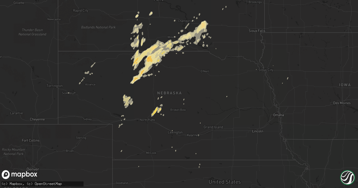
Hail Map in Nebraska on May 22, 2016
Get this storm
May 22 map
$229
one time, instant access
Download today. No call, no setup
Keep the $229
Bought the map and want the full workflow? Apply the entire $229 to a subscription within 7 days. None of it is wasted.
Every map, not just this one
This buys you this map. Subscription and you get every map we run, in the markets you choose from a few cities to whole states to nationwide. Plus real-time alerts the moment a storm fires.
Contact data
Name, contact info, occupancy, even credit band for addresses in the footprint. You go from where it hit to who to call.
Become the source they trust
Unlimited branding weather history reports on demand. You already have the documented answer ready for the property owner, and you are the one who showed up with it.
Property data and RoofTrace estimates
Pull up any address you have got, its value and the exact code rules for that jurisdiction, straight from One Click Code. Then RoofTrace estimates the squares, pitch, and roof value, priced the way you price.
Storm reports in Nebraska
Nebraska
| Date | Description |
|---|---|
| 05/22/20166:54 PM CDT | Delayed report from sunday...may 22nd. Wind gust was measured using cwop davis wx e7498 equipment... With open exposure. |
| 05/22/20166:53 PM CDT | A local report indicates 1.00 inch wind near SE STAPLETON |
| 05/22/20166:53 PM CDT | A local report indicates 1.00 inch wind near 4 SE STAPLETON |
| 05/22/20166:43 PM CDT | A local report indicates 61 MPH wind near VALENTINE |
| 05/22/20166:40 PM CDT | A local report indicates 1.00 inch wind near VALENTINE |
| 05/22/20166:35 PM CDT | Est 60+ mph gust |
| 05/22/20166:27 PM CDT | A local report indicates 1.75 inch wind near 8 SW VALENTINE |
| 05/22/20165:35 PM CDT | Nickel to quarter size hail...deck is covered. |
| 05/22/20165:05 PM CDT | A local report indicates 1.00 inch wind near 8 S NENZEL |
| 05/22/20164:16 PM CDT | A local report indicates 1.50 inch wind near 17 SSW NENZEL |
| 05/22/20163:30 PM CDT | A local report indicates 1.00 inch wind near 17 SSW NENZEL |
| 05/21/201610:20 PM CDT | Nickel to quarter size hail. Over 1 in. Rain. Time estimated from radar |
| 05/21/20169:56 PM CDT | A few quarter size hail pieces fell...however...most of the hail was nickel size in nature. In addition to the hail...winds gusted approximately 40 to 50 mph. |
| 05/21/20169:30 PM CDT | A local report indicates 1.50 inch wind near 21 NE WHITMAN |
| 05/21/20168:58 PM CDT | Residents still without power. Ground is turning white from hail accumulation. |
| 05/21/20168:21 PM CDT | Residents lost power as storm went through. |
| 05/21/20168:05 PM CDT | Over an inch of rain was estimated over the past 15 minutes. |
| 05/21/20168:05 PM CDT | A local report indicates 1.75 inch wind near 4 W ARNOLD |
| 05/21/20167:52 PM CDT | Via social media |
| 05/21/20167:47 PM CDT | Ground is starting to become covered |
| 05/21/20167:40 PM CDT | Via social media |
| 05/21/20167:20 PM CDT | A local report indicates 1.00 inch wind near 4 NE VALENTINE |
| 05/21/20167:00 PM CDT | A local report indicates 1.75 inch wind near 8 SSE STAPLETON |
All States Impacted by Hail Map on May 22, 2016
Cities Impacted by Hail Map on May 22, 2016
- Platte, SD
- Kimball, SD
- White Lake, SD
- Ypsilanti, ND
- Jamestown, ND
- Gackle, ND
- Selby, SD
- Edinburg, ND
- Hamill, SD
- Stratford, TX
- Wilson, OK
- Ardmore, OK
- Lone Grove, OK
- Maxwell, NE
- Stapleton, NE
- Mission, SD
- Valentine, NE
- Lakin, KS
- Deerfield, KS
- Holcomb, KS
- Childress, TX
- Quanah, TX
- Paducah, TX
- Chillicothe, TX
- Montpelier, ND
- Kulm, ND
- Jud, ND
- Lakeview, TX
- Memphis, TX
- White River, SD
- Big Spring, TX
- Clarendon, TX
- Lorenzo, TX
- Colome, SD
- Sparks, NE
- Sargent, NE
- Norris, SD
- Marion, SC
- Parmelee, SD
- Mountain View, OK
- Gruver, TX
- Canadian, TX
- Stinnett, TX
- Spearman, TX
- Perryton, TX
- Miami, TX
- Pampa, TX
- Woodworth, ND
- Pingree, ND
- Walters, OK
- Grandfield, OK
- Devol, OK
- Gail, TX
- Mound City, SD
- Fredonia, ND
- Lehr, ND
- Kilgore, NE
- Cody, NE
- Nenzel, NE
- Dalhart, TX
- Winner, SD
- Hemingford, NE
- Belvidere, SD
- Crowell, TX
- Post, TX
- Herreid, SD
- Crary, ND
- Comstock, TX
- Dryden, TX
- Davidson, OK
- Binford, ND
- Cooperstown, ND
- Wood Lake, NE
- Ralls, TX
- Floydada, TX
- Henrietta, TX
- Scotland, TX
- Windthorst, TX
- Tell, TX
- Hedley, TX
- Wishek, ND
- Lakota, ND
- Garden City, TX
- Groom, TX
- White Deer, TX
- Liberal, KS
- Hugoton, KS
- Hooker, OK
- Tahoka, TX
- Odonnell, TX
- Ashley, ND
- Lenorah, TX
- Knott, TX
- Stanton, TX
- Arnold, NE
- Brady, NE
- Copeland, KS
- Sublette, KS
- Wakpala, SD
- Thedford, NE
- Altus, OK
- Atwood, KS
- Hoople, ND
- Burke, SD
- Gregory, SD
- Ravenna, NE
- Lamesa, TX
- Crosbyton, TX
- Medina, ND
- Tappen, ND
- Bowie, TX
- Jacksboro, TX
- Alvord, TX
- Chico, TX
- Sunset, TX
- Bellevue, TX
- North Platte, NE
- Reidsville, NC
- Garden City, KS
- Mchenry, ND
- New Rockford, ND
- Leoti, KS
- Lockney, TX
- Byers, TX
- Brooten, MN
- Pukwana, SD
- Vernon, TX
- Burlington, NC
- Bemidji, MN
- Matador, TX
- Flomot, TX
- Justiceburg, TX
- Tarzan, TX
- Eagle Butte, SD
- Gettysburg, SD
- Dickey, ND
- Holliday, TX
- Iowa Park, TX
- Electra, TX
- Turtle Lake, ND
- Butte, ND
- Ruso, ND
- Carrington, ND
- Glenham, SD
- Turkey, TX
- Warwick, ND
- Grace City, ND
- Ulysses, KS
- Eldorado, OK
- Gould, OK
- Whitman, NE
- Crookston, NE
- Springview, NE
- Temple, OK
- Goodrich, ND
- Wing, ND
- Guymon, OK
- Hardesty, OK
- Carnegie, OK
- Elmer, OK
- Marienthal, KS
- Scott City, KS
- Plains, KS
- Voltaire, ND
- Frederick, OK
- Claude, TX
- Lake Andes, SD
- Geddes, SD
- Ackerly, TX
- Oakley, KS
- Saint Francis, SD
- Tuthill, SD
- Port Arthur, TX
- Washburn, ND
- Underwood, ND
- Gainesville, TX
- Collinsville, TX
- Hague, ND
- Brocket, ND
- Pelican Rapids, MN
- Menahga, MN
- Hollister, OK
- Goodwell, OK
- Mizpah, MN
- Northome, MN
- Gibbon, NE
- Trail City, SD
- Sutherland, NE
- Tryon, NE
- Harrold, TX
- Dallas, SD
- Aneta, ND
- Galveston, TX
- Devers, TX
- Olustee, OK
- Odell, TX
- Tipton, OK
- Zeeland, ND
- Eureka, SD
- Artesian, SD
- Smith Center, KS
- Max, ND
- Garrison, ND
- Langdon, ND
- Alsen, ND
- Pierre, SD
- Pekin, ND
- Tolna, ND
- Balko, OK
- Roosevelt, OK
- Hobart, OK
- Reliance, SD
- Kennebec, SD
- Wellington, TX
- Tioga, TX
- Geronimo, OK
- Oxford, NE
- Hollis, OK
- Corsica, SD
- Armour, SD
- Cee Vee, TX
- Harrison, SD
- Balfour, ND
- Cozad, NE
- Duke, OK
- Muenster, TX
- Forestburg, TX
- Dawson, ND
- Stickney, SD
- Waterbury, NE
- Grafton, ND
- Edgeley, ND
- Roaring Springs, TX
- Winona, KS
- Graham, NC
- Snow Camp, NC
- Mangum, OK
- Gothenburg, NE
- Burlington, OK
- Kiowa, KS
- Hazelton, KS
- Murdo, SD
- Draper, SD
- Comstock, NE
- Glenfield, ND
- Midland, TX
- Big Lake, TX
- Glenwood, MN
- Midland, SD
- Alliance, NE
- Mills, NE
- Arthur, NE
- Ringling, OK
- Niagara, ND
- Randlett, OK
- Lankin, ND
- Hay Springs, NE
- Mercer, ND
- Chamberlain, SD
- Grant, NE
- Ogallala, NE
- Gotebo, OK
- Plankinton, SD
- Altus Afb, OK
- Berlin, ND
- Oklaunion, TX
- Headrick, OK
- Loveland, OK
- Quitaque, TX
- Spiritwood, ND
- Sanborn, ND
- Dunning, NE
- Pamplico, SC
- Long Valley, SD
- Napoleon, ND
- Scottsbluff, NE
- Gering, NE
- Mapleton, IA
- Hinton, IA
- Parks, NE
- Arapahoe, NE
- Higgins, TX
- Hyannis, NE
- Newman Grove, NE
- Villard, MN
- Sauk Centre, MN
- Liberty, TX
- Tower City, ND
- Page, ND
- Wichita Falls, TX
- Ridgeview, SD
- Battle Creek, IA
- Chatham, VA
- Lawton, ND
- Keystone, NE
- Marion, ND
- Buchanan, ND
- Tuttle, ND
- Wadena, MN
- Gresham, SC
- Crystal, ND
- Lone Wolf, OK
- Bloomington, NE
- Wagner, SD
- Litchville, ND
- Mcville, ND
- Lamoure, ND
- Fullerton, ND
- Alva, OK
- Gunter, TX
- Mobridge, SD
- Pollock, SD
- Lemoyne, NE
- Florence, SC
- Lelia Lake, TX


