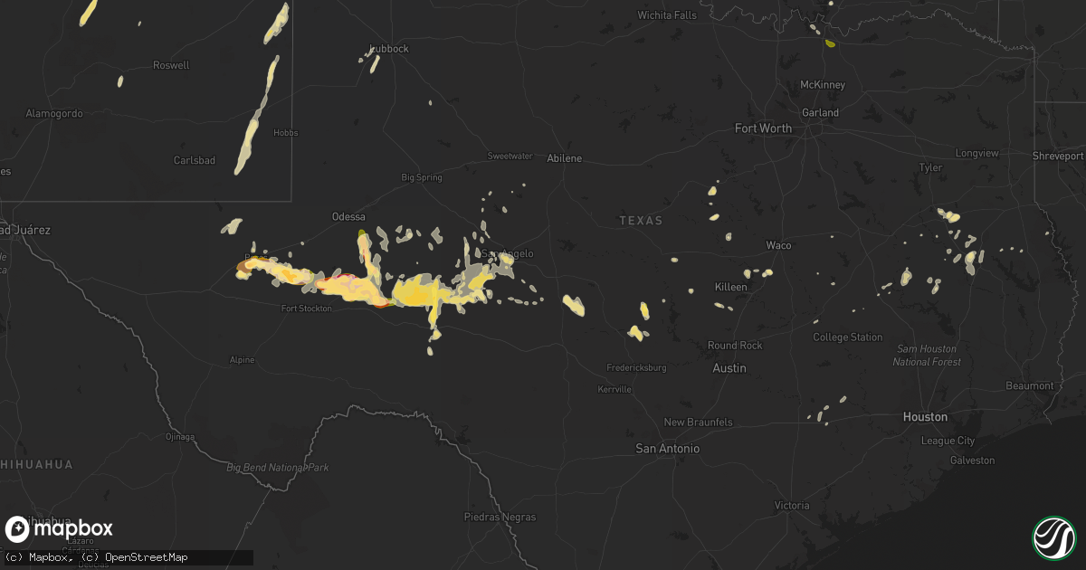
Hail Map in Texas on May 18, 2015
Get this storm
May 18 map
$229
one time, instant access
Download today. No call, no setup
Keep the $229
Bought the map and want the full workflow? Apply the entire $229 to a subscription within 7 days. None of it is wasted.
Every map, not just this one
This buys you this map. Subscription and you get every map we run, in the markets you choose from a few cities to whole states to nationwide. Plus real-time alerts the moment a storm fires.
Contact data
Name, contact info, occupancy, even credit band for addresses in the footprint. You go from where it hit to who to call.
Become the source they trust
Unlimited branding weather history reports on demand. You already have the documented answer ready for the property owner, and you are the one who showed up with it.
Property data and RoofTrace estimates
Pull up any address you have got, its value and the exact code rules for that jurisdiction, straight from One Click Code. Then RoofTrace estimates the squares, pitch, and roof value, priced the way you price.
Storm reports in Texas
Texas
| Date | Description |
|---|---|
| 05/18/20156:59 PM CDT | A local report indicates 1.00 inch wind near 2 N COYANOSA |
| 05/18/20156:55 PM CDT | A local report indicates 1.00 inch wind near 1 N COYANOSA |
| 05/18/20155:53 PM CDT | Tornado spotted on ground for approx. 5 minutes 11 miles south of pecos between u.s. 285 and fm 1450. |
| 05/18/20155:45 PM CDT | Hail up to 1 foot deep covering us 285 5 miles southeast of pecos with near zero visibility. |
| 05/18/20155:25 PM CDT | Tornado lasted 2 minutes |
| 05/18/20155:17 PM CDT | Hail up to 2 inches in diameter covering the ground. |
| 05/18/20155:17 PM CDT | Ping pong sized hail |
| 05/18/20155:11 PM CDT | Report received from the reeves county sheriffs office. |
| 05/18/20155:01 PM CDT | A local report indicates 2.00 inch wind near 7 SSW PECOS |
| 05/18/20154:45 PM CDT | A local report indicates 1.50 inch wind near 8 W TOYAH LAKE |
| 05/18/20154:45 PM CDT | A local report indicates 1.00 inch wind near 3 SW PECOS |
| 05/18/20154:21 PM CDT | Quarter size hail reported at ida and coker rd 5 miles east of sherman. |
| 05/18/20154:13 AM CDT | Two power poles were knocked down by wind on highway 180 and fm 170. |
| 05/18/20153:45 AM CDT | The snyder mesonet reported 7 severe gusts beginning at 345 am and ending at 425 am. The highest gust reported was 67 mph. |
| 05/18/20152:30 AM CDT | A local report indicates 60 MPH wind near BARNHART |
| 05/18/20152:25 AM CDT | The snyder mesonet reported 3 severe gusts from 225 am to 235 am. Spc forecaster reported major roof damage at a motel in snyder. |
| 05/18/20151:50 AM CDT | At pilot travel center in big lake |
| 05/18/20151:50 AM CDT | A local report indicates 59 MPH wind near 5 SW ST. LAWRENCE |
| 05/18/20151:47 AM CDT | A local report indicates 62 MPH wind near 1 WNW BIG LAKE |
| 05/18/201512:12 AM CDT | Numerous treee limbs down. |
| 05/17/201511:47 PM CDT | A local report indicates 1.75 inch wind near MCCAMEY |
| 05/17/201511:15 PM CDT | A local report indicates 58 MPH wind near 6 SW SAN ANGELO |
| 05/17/201511:13 PM CDT | A local report indicates 60 MPH wind near 6 SSW SAN ANGELO |
| 05/17/201510:51 PM CDT | A local report indicates 58 MPH wind near 12 S SAN ANGELO |
| 05/17/20158:41 PM CDT | Powerlines were down and there were hail drifts. |
| 05/17/20158:28 PM CDT | Winds caused a 20 foot tree to split in half. |
| 05/17/20158:15 PM CDT | A local report indicates 60 MPH wind near 8 NE BARNHART |
| 05/17/20157:52 PM CDT | Brief touchdown. |
| 05/17/20157:25 PM CDT | A local report indicates 1.75 inch wind near COYANOSA |
All States Impacted by Hail Map on May 18, 2015
Cities Impacted by Hail Map on May 18, 2015
- Midway, TX
- Leona, TX
- Centerville, TX
- Causey, NM
- Rogers, NM
- Smyrna, GA
- Marietta, GA
- Moriarty, NM
- Estancia, NM
- Mosquero, NM
- Rusk, TX
- Eldorado, TX
- Goldthwaite, TX
- Oakley, ID
- Hico, TX
- Iredell, TX
- Anton, TX
- Moody, TX
- Tinnie, NM
- Durant, OK
- Mead, OK
- San Augustine, TX
- Chireno, TX
- Pine Apple, AL
- Franklinville, NY
- Troy, TX
- Encino, NM
- Vaughn, NM
- Cleveland, TN
- Tucumcari, NM
- Conchas Dam, NM
- Lufkin, TX
- Elkhart, TX
- Laneville, TX
- Morris, GA
- House, NM
- Castell, TX
- Llano, TX
- Kennard, TX
- Oberlin, LA
- Reeves, LA
- Mittie, LA
- Kinder, LA
- Lovington, NM
- Pecos, TX
- Melrose, NM
- Floyd, NM
- Taiban, NM
- Bainbridge, GA
- Ozona, TX
- Robert Lee, TX
- Madill, OK
- North Zulch, TX
- Pottsboro, TX
- Wells, TX
- Alto, TX
- Hext, TX
- Menard, TX
- Brady, TX
- Pollok, TX
- Gatesville, TX
- San Angelo, TX
- Mertzon, TX
- Christoval, TX
- Jemez Springs, NM
- Fort Sumner, NM
- Mcalister, NM
- Mentone, TX
- Reklaw, TX
- Jacksonville, TX
- Garden City, TX
- Stephenville, TX
- New Ulm, TX
- Cat Spring, TX
- Bellville, TX
- Corona, NM
- Big Lake, TX
- Carrizozo, NM
- Columbus, TX
- Wolfforth, TX
- Manchester, PA
- York, PA
- York Haven, PA
- Tatum, NM
- Roswell, NM
- Natchitoches, LA
- Sterling City, TX
- Iraan, TX
- Jal, NM
- Belen, NM
- Midland, TX
- Barnhart, TX
- Coyanosa, TX
- McCamey, TX
- Goodfellow Afb, TX
- Fort Stockton, TX
- Midkiff, TX
- Barstow, TX
- Crane, TX
- Imperial, TX
- Balmorhea, TX
- Milnesand, NM
- Pep, NM
- Melvin, TX
- Port Allen, LA
- Valley Spring, TX
- Collbran, CO
- Kosse, TX
- Ropesville, TX
- Lubbock, TX
- Clovis, NM
- Grady, NM
- Groveton, TX
- Trinity, TX
- Post, TX
- San Saba, TX
- Tahoka, TX
- Mableton, GA
- Austell, GA
- Powder Springs, GA
- Cherokee, TX
- Madisonville, TX
- Crockett, TX
- Lovelady, TX
- Pitkin, LA
- Bluff Dale, TX
- Glen Rose, TX
- Walnut Springs, TX
- Briggs, TX
- Mexia, TX
- Newberg, OR
- Broadview, NM
- Hereford, TX
- Loving, NM
- Lampasas, TX
- Meadow, TX
- Laurel, DE
- Weimar, TX
- Declo, ID
- Hanover, PA
- Littlestown, PA
- Eddy, TX
- Monticello, GA
- Santa Rosa, NM
- Edison, GA
- Atlanta, GA
- Portales, NM
- Texico, NM
- Climax, GA
- Delmar, DE
- Carlsbad, TX
- Blountstown, FL
- Mansfield, GA
- Draper, UT
- Meridian, TX
- Cranfills Gap, TX
- Tishomingo, OK
- Blackwell, TX
- Apalachin, NY
- Owego, NY
- Ray City, GA
- Adel, GA
- Nashville, GA
- Hahira, GA
- Barney, GA
- Cairo, GA
- Georgetown, GA
- Whigham, GA
- Eden, UT
- Monahans, TX
- Las Vegas, NV
- Dry Creek, LA
- Grant, LA
- Shelbyville, TX
- Yeso, NM
- Florence, TX
- Killeen, TX
- Ardmore, OK
- Quitman, GA
- Dover, PA
- Magna, UT
- West Valley City, UT
- Salt Lake City, UT
- West Jordan, UT
- Newark Valley, NY
- Endicott, NY
- Justiceburg, TX
- Mannsville, OK
- Roff, OK
- Franklin, TX
- Denison, TX
- Sherman, TX
- Burley, ID
- Red Oak, GA
- Bryan, TX
- Cedar Valley, UT
- Farwell, TX
- Maryneal, TX
- Diboll, TX
- Middletown, PA
- Bainbridge, PA
- Elizabethtown, PA
- Holden, LA
- Charleston, TN
- Pennington, TX
- Mcdonald, NM
- Salado, TX
- Rutledge, GA
- Sugartown, LA
- Deridder, LA
- Robeline, LA
- Forest Home, AL
- Greenville, AL
- Douglass, TX
- Nacogdoches, TX
- Jay, FL
- Morven, GA
- Fitzhugh, OK
- Raton, NM
- Gause, TX
- Bells, TX
- Whitewright, TX
- Binghamton, NY
- Castle Creek, NY
- Whitney Point, NY


