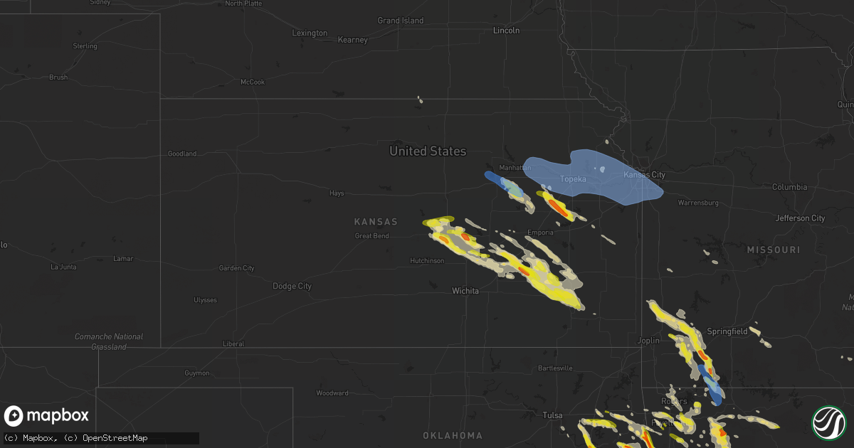
Hail Map in Kansas on May 15, 2022
Get this storm
May 15 map
$229
one time, instant access
Download today. No call, no setup
Keep the $229
Bought the map and want the full workflow? Apply the entire $229 to a subscription within 7 days. None of it is wasted.
Every map, not just this one
This buys you this map. Subscription and you get every map we run, in the markets you choose from a few cities to whole states to nationwide. Plus real-time alerts the moment a storm fires.
Contact data
Name, contact info, occupancy, even credit band for addresses in the footprint. You go from where it hit to who to call.
Become the source they trust
Unlimited branding weather history reports on demand. You already have the documented answer ready for the property owner, and you are the one who showed up with it.
Property data and RoofTrace estimates
Pull up any address you have got, its value and the exact code rules for that jurisdiction, straight from One Click Code. Then RoofTrace estimates the squares, pitch, and roof value, priced the way you price.
Storm reports in Kansas
Kansas
| Date | Description |
|---|---|
| 05/15/20222:37 PM CDT | Said hail was covering the ground. |
| 05/15/20221:44 PM CDT | A local report indicates 1.00 inch wind near HAMILTON |
| 05/15/202212:42 PM CDT | A local report indicates 1.00 inch wind near ALTOONA |
| 05/15/202211:30 AM CDT | A local report indicates 1.00 inch wind near 1 W NEW ALBANY |
| 05/15/202210:49 AM CDT | Delayed report. Received via social media. |
| 05/15/202210:14 AM CDT | Most were quarter sized with a few to the size of half dollar. |
| 05/15/202210:06 AM CDT | Photo sent via email of quarter sized hail. |
| 05/15/20229:47 AM CDT | Emergency management reported tree damage over a four block area with one home damaged from falling tree limbs. |
| 05/15/20228:18 AM CDT | Tree down near kctv5 on granada lane. |
| 05/15/20228:18 AM CDT | 1 inch diameter branches broken off. Pea sized hail. |
| 05/15/20228:14 AM CDT | Measured at ojc airport. |
| 05/15/20228:14 AM CDT | Several twigs and a few larger branches downed on the ground. |
| 05/15/20228:13 AM CDT | 50-60mph wind gusts and half inch hail. Estimated at kansas city speedway eoc. |
| 05/15/20228:11 AM CDT | 135st and pflumm. |
| 05/15/20228:06 AM CDT | 4 to 8 inch diameter tree limbs down near downtown shawnee. |
| 05/15/20228:02 AM CDT | Measured at ixd airport. |
| 05/15/20228:02 AM CDT | Report from mping: 1-inch tree limbs broken; shingles blown off. |
| 05/15/20227:50 AM CDT | Pea sized hail. |
| 05/15/20227:43 AM CDT | Asos station klwc lawrence. |
| 05/15/20227:40 AM CDT | A local report indicates 1.50 inch wind near 3 S MCPHERSON |
| 05/15/20227:38 AM CDT | A local report indicates 1.00 inch wind near 1 E MCPHERSON |
| 05/15/20227:38 AM CDT | A local report indicates 60 MPH wind near 4 W JARBALO |
| 05/15/20227:38 AM CDT | A local report indicates 1.75 inch wind near 1 WSW OSAGE CITY |
| 05/15/20227:37 AM CDT | Report from mping: 1-inch tree limbs broken; shingles blown off. |
| 05/15/20227:36 AM CDT | 12 to 18 inch diameter tree down blocking southbound lanes of us 24/40. |
| 05/15/20227:34 AM CDT | 60 to 65 mph wind gusts. |
| 05/15/20227:30 AM CDT | Fire chief reported 60 mph winds and zero visibility. |
| 05/15/20227:27 AM CDT | At 1227 PM CDT, a severe thunderstorm was located 6 miles southwest of Buffalo, or 7 miles northeast of Fredonia, moving southeast at 40 mph. HAZARD...60 mph wind gusts and quarter size hail. SOURCE...Radar indicated. IMPACT...Hail damage to vehicles is expected. Expect wind damage to roofs, siding, and trees. Locations impacted include... Chanute, Neodesha, Fredonia, Cherryvale, Erie, Thayer, Altoona, Buffalo, Galesburg, Sycamore, Benedict, Earlton, Parsons Tri City Airport, Dennis, Chanute Airport, Lake Parsons and Big Hill Lake. |
| 05/15/20227:25 AM CDT | At 1224 AM CDT, severe thunderstorms were located along a line extending from 4 miles northeast of Osage Hills State Park to 3 miles west of Oologah, moving northeast at 15 mph. HAZARD...60 mph wind gusts and half dollar size hail. SOURCE...Radar indicated. IMPACT...Hail damage to vehicles is expected. Expect wind damage to roofs, siding, and trees. Locations in or near the path include... Bartlesville... Nowata... Dewey... Oologah... Copan... Ramona... Ochelata... Delaware... Talala... Wann... New Alluwe... Bartlesville Municipal Airport... Hulah... Watova... Okesa... Wah Sha She State Park... |
| 05/15/20227:23 AM CDT | 2 foot diameter tree blown down along highway 40 in big springs. |
| 05/15/20227:20 AM CDT | 10 to 12 inch diameter tree limb blown down. |
| 05/15/20227:19 AM CDT | Measured at the ktop asos. |
| 05/15/20227:15 AM CDT | Via social media. Pea to quarter size. |
| 05/15/20227:13 AM CDT | Quarter to half dollar hail falling. |
| 05/15/20227:02 AM CDT | 3 inch diameter tree limbs down. |
| 05/15/20225:35 AM CDT | At 1035 AM CDT, a severe thunderstorm was located 9 miles northwest of Eureka, moving southeast at 35 mph. HAZARD...60 mph wind gusts and half dollar size hail. SOURCE...Radar indicated. IMPACT...Hail damage to vehicles is expected. Expect wind damage to roofs, siding, and trees. Locations impacted include... Eureka, Severy, Fall River, Climax, Eureka City Lake, Fall River Lake, Eureka Airport and Fall River State Park. |
| 05/15/20225:32 AM CDT | At 1032 AM CDT, a severe thunderstorm was located near Dunlap, or 7 miles south of Council Grove, moving southeast at 35 mph. HAZARD...60 mph wind gusts and quarter size hail. SOURCE...Radar indicated. IMPACT...Hail damage to vehicles is expected. Expect wind damage to roofs, siding, and trees. Locations impacted include... Saffordville.This includes Interstate 35 between Mile Markers 112 and 116. |
| 05/15/20225:25 AM CDT | At 1024 AM CDT, a severe thunderstorm was located 8 miles northwest of Bushong, moving southeast at 45 mph. HAZARD...60 mph wind gusts and quarter size hail. SOURCE...Radar indicated. IMPACT...Hail damage to vehicles is expected. Expect wind damage to roofs, siding, and trees. Locations impacted include... Emporia, Council Grove, Americus, Harveyville, Reading, Allen, Admire, Bushong, Dunlap and Council Grove Lake.This includes Kansas Turnpike between mile markers 128 and 154. |
| 05/15/20225:02 AM CDT | At 1001 AM CDT, a severe thunderstorm was located 13 miles east of Burns, or 17 miles southeast of Florence, moving southeast at 35 mph. HAZARD...60 mph wind gusts and half dollar size hail. SOURCE...Radar indicated. IMPACT...Hail damage to vehicles is expected. Expect wind damage to roofs, siding, and trees. Locations impacted include... Cassoday, Matfield Green, Wonsevu and Thrall. This includes Interstate 35 between Mile Markers 87 and 107. |
| 05/15/20224:59 AM CDT | At 959 AM CDT, a severe thunderstorm was located 8 miles north of Dwight, moving southeast at 45 mph. HAZARD...60 mph wind gusts and nickel size hail. SOURCE...Emergency management. IMPACT...Expect damage to roofs, siding, and trees. Locations impacted include... Council Grove, Grandview Plaza, Alta Vista, Dwight, Volland and Council Grove Lake.This includes Interstate 70 between mile markers 301 and 309. |
| 05/15/20224:57 AM CDT | At 957 AM CDT, a severe thunderstorm was located over Liberal, or 11 miles west of Lamar, moving southeast at 40 mph. HAZARD...60 mph wind gusts and quarter size hail. SOURCE...Radar indicated. IMPACT...Hail damage to vehicles is expected. Expect wind damage to roofs, siding, and trees. Locations impacted include... Prairie State Park... Lamar... Golden City... Liberal... Mulberry... Mindenmines... Lamar Heights... Burgess... Oakton... Iantha... Verdella... Kenoma... Hannon... Boston... This includes Interstate 49 between mile markers 57 and 71. |
| 05/15/20223:53 AM CDT | At 853 AM CDT, a severe thunderstorm was located 6 miles north of El Dorado, moving southeast at 40 mph. HAZARD...60 mph wind gusts and quarter size hail. SOURCE...Radar indicated. IMPACT...Hail damage to vehicles is expected. Expect wind damage to roofs, siding, and trees. Locations impacted include... El Dorado, Eureka, Leon, Severy, Latham, Rosalia, Cassoday, Climax, Eureka City Lake, El Dorado State Park, Eureka Airport, El Dorado Airport, Beaumont, El Dorado Lake and Piedmont.This includes Interstate 35 between Mile Markers 70 and 93. |
| 05/15/20222:55 AM CDT | At 755 AM CDT, a severe thunderstorm was located near Peabody, moving southeast at 45 mph. HAZARD...Two inch hail and 60 mph wind gusts. SOURCE...Radar indicated. IMPACT...People and animals outdoors will be injured. Expect hail damage to roofs, siding, windows, and vehicles. Expect wind damage to roofs, siding, and trees. Locations impacted include... Newton, Hesston, Hillsboro, Marion, North Newton, Moundridge, Peabody, Galva, Canton, Florence, Goessel, Walton, Elbing, Burns, Lehigh, Cassoday, Matfield Green, Cedar Point, Newton Airport and Wonsevu.This includes the following highways... Interstate 135 between Mile Markers 32 and 58. Interstate 35 between Mile Markers 78 and 101. |
| 05/15/20222:42 AM CDT | At 741 AM CDT, a severe thunderstorm was located 6 miles northwest of Burns, or 6 miles east of Peabody, moving east at 30 mph. HAZARD...60 mph wind gusts and quarter size hail. SOURCE...Radar indicated. IMPACT...Hail damage to vehicles is expected. Expect wind damage to roofs, siding, and trees. Locations impacted include... Burns, Cassoday, Matfield Green and Wonsevu. This includes Interstate 35 between Mile Markers 88 and 105. |
| 05/15/20222:31 AM CDT | At 730 AM CDT, severe thunderstorms were located along a line extending from near Clinton to near Pomona Lake, moving east at 45 mph. HAZARD...60 mph wind gusts and nickel size hail. SOURCE...Radar indicated. IMPACT...Expect damage to roofs, siding, and trees. Locations impacted include... Ottawa, Baldwin City, Carbondale, Richland, Wellsville, Auburn, Overbrook, Centropolis, Pomona, Scranton, Princeton, Lane, Rantoul, Pomona Lake and Globe.This includes the following highways... Interstate 35 between mile markers 176 and 198. Kansas Turnpike between mile markers 165 and 171. |
| 05/15/20222:28 AM CDT | At 727 AM CDT, a severe thunderstorm was located 5 miles northwest of Osage City, moving southeast at 50 mph. HAZARD...Golf ball size hail and 60 mph wind gusts. SOURCE...Radar indicated. IMPACT...People and animals outdoors will be injured. Expect hail damage to roofs, siding, windows, and vehicles. Expect wind damage to roofs, siding, and trees. Locations impacted include... Osage City, Lyndon, Burlingame, Waverly, Williamsburg, Quenemo, Melvern, Olivet, Beto Junction, Melvern Lake and Harris.This includes the following highways... Interstate 35 between mile markers 151 and 175. Kansas Turnpike between mile markers 147 and 157. |
| 05/15/20222:22 AM CDT | At 721 AM CDT, severe thunderstorms were located along a line extending from 3 miles northeast of Winchester to Richland, moving east at 30 mph. HAZARD...60 mph wind gusts and nickel size hail. SOURCE...Trained weather spotters. At 720 AM Topeka Billard Airport reported a wind gust to 61 mph. IMPACT...Expect damage to roofs, siding, and trees. Locations impacted include... Topeka, Lawrence, Baldwin City, Oskaloosa, Tecumseh, Eudora, Richland, Perry, McLouth, Meriden, Ozawkie, Nortonville, Lecompton, Clinton, Winchester, Lone Star, Pleasant Grove, Vinland, Pauline and Williamstown.This includes Kansas Turnpike between mile markers 172 and 205. |
| 05/15/20222:13 AM CDT | At 712 AM CDT, a severe thunderstorm was located near Gypsum, or 8 miles southeast of Salina, moving east at 35 mph. HAZARD...60 mph wind gusts and quarter size hail. SOURCE...Radar indicated. IMPACT...Hail damage to vehicles is expected. Expect wind damage to roofs, siding, and trees. Locations impacted include... Salina, Assaria, Gypsum, Lincolnville, Ramona, New Cambria, Tampa, Lost Springs, Bridgeport, Salina Airport and Kipp.This includes the following highways... Interstate 135 between Mile Markers 75 and 95. Interstate 70 between Mile Markers 251 and 266. |
| 05/15/20222:02 AM CDT | At 702 AM CDT, a severe thunderstorm was located over Galva, moving east at 35 mph. HAZARD...60 mph wind gusts and quarter size hail. SOURCE...Radar indicated. IMPACT...Hail damage to vehicles is expected. Expect wind damage to roofs, siding, and trees. Locations impacted include... Mcpherson, Lindsborg, Hillsboro, Marion, Galva, Canton, Florence, Marquette, Little River, Goessel, Lehigh, Windom, Durham, Mcpherson Airport, Roxbury, Marion Lake, Kanopolis Lake, Pilsen and Kanopolis State Park.This includes Interstate 135 between Mile Markers 53 and 75. |
| 05/15/20221:57 AM CDT | At 657 AM CDT, a severe thunderstorm was located 5 miles northwest of Eskridge, moving southeast at 55 mph. HAZARD...Ping pong ball size hail and 60 mph wind gusts. SOURCE...Radar indicated. IMPACT...People and animals outdoors will be injured. Expect hail damage to roofs, siding, windows, and vehicles. Expect wind damage to roofs, siding, and trees. Locations impacted include... Osage City, Carbondale, Eskridge, Dover, Auburn, Overbrook, Lyndon, Burlingame, Scranton, Harveyville, Keene and Pomona Lake.This includes Kansas Turnpike between mile markers 151 and 171. |
| 05/15/20221:47 AM CDT | At 647 AM CDT, a severe thunderstorm was located near Goessel, or near Hesston, moving east at 35 mph. HAZARD...60 mph wind gusts and quarter size hail. SOURCE...Radar indicated. IMPACT...Hail damage to vehicles is expected. Expect wind damage to roofs, siding, and trees. Locations impacted include... Hesston, Peabody, Florence, Goessel, Walton and Burns. This includes Interstate 135 between Mile Markers 38 and 46. |
| 05/15/20221:25 AM CDT | At 625 AM CDT, a severe thunderstorm was located near Beverly, moving east at 30 mph. HAZARD...Quarter size hail. SOURCE...Radar indicated. IMPACT...Damage to vehicles is expected. Locations impacted include... Minneapolis, Bennington, Tescott, Culver, Niles and Ada. |
| 05/15/20221:19 AM CDT | At 618 AM CDT, severe thunderstorms were located along a line extending from Wheaton to 6 miles southeast of Ogden, moving east at 50 mph. HAZARD...60 mph wind gusts and quarter size hail. SOURCE...Radar indicated. IMPACT...Hail damage to vehicles is expected. Expect wind damage to roofs, siding, and trees. Locations impacted include... Manhattan, Wamego, Holton, Rossville, Alma, Westmoreland, Blaine, St. Marys, Ogden, Onaga, St. George, Maple Hill, Mayetta, McFarland, Paxico, Belvue, Emmett, Louisville, Circleville and Delia.This includes Interstate 70 between mile markers 316 and 348. |
| 05/15/20221:09 AM CDT | At 608 AM CDT, a severe thunderstorm was located near Lincoln, moving east at 35 mph. HAZARD...60 mph wind gusts and quarter size hail. SOURCE...Radar indicated. IMPACT...Hail damage to vehicles is expected. Expect wind damage to roofs, siding, and trees. Locations impacted include... Salina, Lincoln, Beverly, New Cambria, Barnard, Glendale, Westfall, Salina Airport and Kipp.This includes the following highways... Interstate 135 between Mile Markers 89 and 95. Interstate 70 between Mile Markers 235 and 261. |
| 05/15/202212:21 AM CDT | At 521 AM CDT, a severe thunderstorm was located near Horton, moving southeast at 30 mph. HAZARD...Quarter size hail. SOURCE...Radar indicated. IMPACT...Damage to vehicles is expected. Locations impacted include... Effingham, Lancaster, Muscotah and Huron. |
| 05/15/202212:11 AM CDT | At 510 AM CDT, a severe thunderstorm was located over Kickapoo Reservation, moving east-southeast at 30 mph. HAZARD...Half dollar size hail. SOURCE...Radar indicated. IMPACT...Damage to vehicles is expected. Locations impacted include... Horton, Everest, Whiting, Netawaka, Powhattan, Willis and Kickapoo Reservation. |
| 05/14/202210:44 PM CDT | At 344 AM CDT, a severe thunderstorm was located near Corning, moving southeast at 30 mph. HAZARD...Quarter size hail. SOURCE...Radar indicated. IMPACT...Damage to vehicles is expected. Locations impacted include... Centralia, Wetmore, Corning and Goff. |
| 05/14/20229:13 PM CDT | At 212 PM CDT, a severe thunderstorm was located near Toronto, or 11 miles southwest of Yates Center, moving southeast at 40 mph. HAZARD...Quarter size hail. SOURCE...Trained weather spotters have reported one inch hail in Hamilton. IMPACT...Damage to vehicles is expected. Locations impacted include... Yates Center, Altoona, Toronto, Buffalo, Benedict, Coyville, Cross Timbers State Park, Toronto Lake, Batesville and Rose. |
| 05/14/20228:57 PM CDT | At 157 AM CDT, a severe thunderstorm was located 9 miles north of White Oak, moving northeast at 20 mph. HAZARD...60 mph wind gusts and quarter size hail. SOURCE...Radar indicated. IMPACT...Hail damage to vehicles is expected. Expect wind damage to roofs, siding, and trees. Locations in or near the path include... Miami... Welch... Bluejacket... Narcissa... Pyramid Corners... Centralia... Centrailia... This includes Interstate 44 between mile markers 303 and 308. |
| 05/14/20228:36 PM CDT | At 136 PM CDT, a severe thunderstorm was located over Hamilton, or 10 miles south of Madison, moving southeast at 40 mph. HAZARD...Quarter size hail. SOURCE...Radar indicated. IMPACT...Damage to vehicles is expected. Locations impacted include... Toronto, Hamilton, Virgil, Cross Timbers State Park, Toronto Lake, Batesville, Eureka City Lake and Fall River Lake. |
| 05/14/20228:12 PM CDT | At 111 AM CDT, severe thunderstorms were located along a line extending from 7 miles west of Delaware to 3 miles south of Chelsea, moving northeast at 10 mph. HAZARD...60 mph wind gusts and half dollar size hail. SOURCE...Radar indicated. IMPACT...Hail damage to vehicles is expected. Expect wind damage to roofs, siding, and trees. Locations in or near the path include... Nowata... Chelsea... South Coffeyville... Delaware... Lenapah... Wann... New Alluwe... Watova... White Oak... Bushyhead...This includes Interstate 44 between mile markers 260 and 279. |
All States Impacted by Hail Map on May 15, 2022
Cities Impacted by Hail Map on May 15, 2022
- Marshall, IL
- Dennison, IL
- Attica, IN
- Portageville, MO
- Hayti, MO
- Ridgely, TN
- Tiptonville, TN
- Yellville, AR
- Everton, AR
- Bonne Terre, MO
- French Village, MO
- South Greenfield, MO
- Miller, MO
- Sainte Genevieve, MO
- Pleasant Hall, PA
- Orrstown, PA
- Upperstrasburg, PA
- Willow Hill, PA
- Fort Loudon, PA
- Shippensburg, PA
- Fannettsburg, PA
- Chambersburg, PA
- Ellsinore, MO
- Hardinsburg, KY
- Blairs Mills, PA
- Humboldt, TN
- Trenton, TN
- Harned, KY
- Webster, KY
- Kinmundy, IL
- Marshall, AR
- Saint Joe, AR
- Harriet, AR
- Valley Springs, AR
- Western Grove, AR
- Harrison, AR
- Blackwell, MO
- Cadet, MO
- De Soto, MO
- Marshfield, MO
- Rector, AR
- Marmaduke, AR
- Green Forest, AR
- Berryville, AR
- Eureka Springs, AR
- Martinsville, IL
- Hensley, AR
- Mabelvale, AR
- Little Rock, AR
- Malden, MO
- Piggott, AR
- Gideon, MO
- Holcomb, MO
- Clarkton, MO
- Campbell, MO
- Gibson, MO
- Greenway, AR
- Parma, MO
- Caryville, FL
- Cottonwood, AL
- Preston, MS
- Marble Falls, AR
- Oark, AR
- Hagarville, AR
- Clarksville, AR
- Deer, AR
- Jasper, AR
- Ponca, AR
- Huntsville, AR
- Kingston, AR
- Witter, AR
- Pettigrew, AR
- Ozone, AR
- Parthenon, AR
- Alpena, AR
- Compton, AR
- Bigelow, AR
- Salem, IL
- Whitewright, TX
- Savoy, TX
- Bonham, TX
- Ector, TX
- Otterbein, IN
- Atchison, KS
- Pangburn, AR
- Wappapello, MO
- Bristow, OK
- Adams, OR
- Junction City, KS
- Council Grove, KS
- Alma, KS
- Dwight, KS
- Alta Vista, KS
- White City, KS
- Allen, KS
- Fort Riley, KS
- Saint Paul, AR
- West Union, IL
- Oskaloosa, KS
- Dardanelle, AR
- Paris, AR
- Danville, AR
- Havana, AR
- Belleville, AR
- Troy, AL
- Foley, AL
- Sanger, TX
- Sulphur, OK
- Gainesville, TX
- Stonewall, OK
- Lake Dallas, TX
- Wylie, TX
- Collinsville, TX
- Ringling, OK
- Mannsville, OK
- Ada, OK
- Ardmore, OK
- Garland, TX
- Decatur, TX
- Forestburg, TX
- Tioga, TX
- Plano, TX
- Thackerville, OK
- Aubrey, TX
- Saint Jo, TX
- Tishomingo, OK
- Lindsay, TX
- Springer, OK
- Mckinney, TX
- Burneyville, OK
- Little Elm, TX
- Carrollton, TX
- Lavon, TX
- Leon, OK
- Rockwall, TX
- Milburn, OK
- Denton, TX
- Royse City, TX
- Frisco, TX
- The Colony, TX
- Rosston, TX
- Allen, TX
- Overbrook, OK
- Wilson, OK
- Era, TX
- Princeton, TX
- Dallas, TX
- Madill, OK
- Fitzhugh, OK
- Richardson, TX
- Celina, TX
- Marietta, OK
- Muenster, TX
- Whitesboro, TX
- Prosper, TX
- Krum, TX
- Healdton, OK
- Roff, OK
- Mill Creek, OK
- Valley View, TX
- Davis, OK
- Pilot Point, TX
- Lone Grove, OK
- Fayetteville, AR
- Elkins, AR
- Winslow, AR
- Taylorville, IL
- Hartman, AR
- Hickman, KY
- Pineville, MO
- Rogers, AR
- Lowell, AR
- Springdale, AR
- Bentonville, AR
- Bella Vista, AR
- Pea Ridge, AR
- Seligman, MO
- McClure, IL
- Bixby, OK
- Haskell, OK
- Tampa, KS
- Durham, KS
- Marion, KS
- Rossville, TN
- Moscow, TN
- Lamar, AR
- Eagle Rock, MO
- Tahlequah, OK
- Parks, AR
- Etta, MS
- New Albany, MS
- Myrtle, MS
- Bradford, TN
- Perryville, MO
- Saint Mary, MO
- Bainbridge, GA
- Holly Grove, AR
- Howe, TX
- Jackson, AL
- Hornbeak, TN
- Bloomsdale, MO
- Milledgeville, TN
- Morris Chapel, TN
- Grapeland, TX
- Elkhart, TX
- Denham Springs, LA
- Greenwell Springs, LA
- Clinton, LA
- Thorsby, AL
- Booneville, AR
- Sulligent, AL
- Beaverton, AL
- Millport, AL
- Kennedy, AL
- Vernon, AL
- Jacob, IL
- Williamsburg, KS
- Princeton, KS
- Quincy, MO
- Farmington, MO
- Webber, KS
- Dana, IN
- Chrisman, IL
- Cayuga, IN
- Kingman, IN
- Montezuma, IN
- Hillsdale, IN
- Broken Arrow, OK
- Altus, AR
- Coal Hill, AR
- Okmulgee, OK
- Silva, MO
- Patterson, MO
- Greenville, MO
- Lowndes, MO
- Flat Rock, IL
- Strong City, KS
- Hindsville, AR
- Wesley, AR
- Siloam Springs, AR
- Birch Tree, MO
- Hamilton, MS
- Pryor, OK
- Locust Grove, OK
- Chouteau, OK
- Gentry, AR
- Colcord, OK
- Parsons, KS
- Peggs, OK
- Proctor, OK
- Rose, OK
- Summers, AR
- Rudy, AR
- Chester, AR
- Canehill, AR
- Westville, OK
- Van Buren, AR
- Evansville, AR
- Cedarville, AR
- Prairie Grove, AR
- Alma, AR
- Uniontown, AR
- Stilwell, OK
- Lincoln, AR
- Natural Dam, AR
- Mason, IL
- Louisville, IL
- Roland, AR
- Guide Rock, NE
- Superior, NE
- Doniphan, MO
- Breese, IL
- Germantown, IL
- Doe Run, MO
- Mascoutah, IL
- Reading, KS
- Oaktown, IN
- Palestine, IL
- Lockwood, MO
- Golden City, MO
- Manila, AR
- Hulbert, OK
- Wagoner, OK
- Inola, OK
- Montevallo, AL
- Calera, AL
- Robertsdale, AL
- Matthews, MO
- New Madrid, MO
- Harwood, MO
- Walker, MO
- Charleston, MO
- Checotah, OK
- Lavinia, TN
- Milan, TN
- Medina, TN
- Paris, IL
- Robinson, IL
- Veedersburg, IN
- Shell Knob, MO
- Pierce City, MO
- Lampe, MO
- Sarcoxie, MO
- Galena, MO
- Kimberling City, MO
- Ash Grove, MO
- Aurora, MO
- Cassville, MO
- Stotts City, MO
- Monett, MO
- Lamar, MO
- Wentworth, MO
- Cape Fair, MO
- Jasper, MO
- Liberal, MO
- Purdy, MO
- Crane, MO
- La Russell, MO
- Golden, MO
- Blue Eye, MO
- Oak Grove, AR
- Mount Vernon, MO
- Marionville, MO
- Reeds, MO
- Carthage, MO
- Verona, MO
- Freistatt, MO
- Reeds Spring, MO
- Anniston, MO
- East Prairie, MO
- Brundidge, AL
- Louisville, AL
- Banks, AL
- Lyndon, KS
- Quenemo, KS
- Burlingame, KS
- Eskridge, KS
- Lebo, KS
- Harveyville, KS
- Osage City, KS
- Vassar, KS
- Alton, MO
- Cammal, PA
- Valles Mines, MO
- Boynton, OK
- Biscoe, AR
- Williamsport, IN
- West Lebanon, IN
- Centerville, KS
- Greeley, KS
- Garnett, KS
- Parker, KS
- Perrysville, IN
- Covington, IN
- Wingo, KY
- Clinton, KY
- Annapolis, MO
- Lesterville, MO
- Ironton, MO
- Seymour, MO
- Fordland, MO
- Cave Springs, AR
- Chunchula, AL
- Citronelle, AL
- Blytheville, AR
- Ripley, TN
- Hornersville, MO
- Steele, MO
- Luxora, AR
- McIntosh, AL
- Shady Point, OK
- Gans, OK
- Braggs, OK
- Spiro, OK
- Warner, OK
- Sallisaw, OK
- Stigler, OK
- Mccurtain, OK
- Heavener, OK
- Muskogee, OK
- Coweta, OK
- Webbers Falls, OK
- Porum, OK
- Wister, OK
- Oktaha, OK
- Bokoshe, OK
- Howe, OK
- Porter, OK
- Gore, OK
- Poteau, OK
- Muldrow, OK
- Vian, OK
- Cameron, OK
- Keota, OK
- Ashford, AL
- West Point, MS
- Aberdeen, MS
- Columbus, MS
- Crawford, MS
- Fort Walton Beach, FL
- Navarre, FL
- Gulf Breeze, FL
- Defuniak Springs, FL
- Milton, FL
- Eglin Afb, FL
- Niceville, FL
- Freeport, FL
- Valparaiso, FL
- Malvern, AR
- Combs, AR
- Parrish, AL
- Townley, AL
- Carbon Hill, AL
- Jasper, AL
- Oakman, AL
- Berry, AL
- West Blocton, AL
- Brierfield, AL
- Centreville, AL
- Coffeeville, AL
- Gilbertown, AL
- Thomasville, AL
- Toxey, AL
- Needham, AL
- Butler, AL
- Tibbie, AL
- Aliceville, AL
- Macon, MS
- Greenville, TX
- Panama City, FL
- Scooba, MS
- Emelle, AL
- Pattison, MS
- Union Church, MS
- Houston, MS
- Prairie, MS
- Okolona, MS
- McLouth, KS
- Sherman, TX
- Mayersville, MS
- Sondheimer, LA
- Transylvania, LA
- Greenwood, MS
- Oxford, MS
- Pope, MS
- Courtland, MS
- Batesville, MS
- Enid, MS
- Water Valley, MS
- Wells, TX
- Alto, TX
- Irvington, AL
- Buras, LA
- Yates Center, KS
- Hendrix, OK
- El Dorado, KS
- Fort White, FL
- Lake City, FL
- Archer, FL
- Newberry, FL
- Polk City, FL
- Auburndale, FL
- Lake Alfred, FL
- Henning, TN
- Covington, TN
- Coden, AL
- Centrahoma, OK
- Allen, OK
- Tupelo, OK
- Coalgate, OK
- Belle Chasse, LA
- Harvey, LA
- Braithwaite, LA
- Marrero, LA
- Albion, IL
- Hollandale, MS
- Fort Lauderdale, FL
- Pottsboro, TX
- Kingston, OK
- Denison, TX
- Park Hill, OK
- Welling, OK
- Bunch, OK
- Cookson, OK
- Newellton, LA
- Severy, KS
- Eureka, KS
- Somerville, TN
- Mason, TN
- Brighton, TN
- Eldridge, AL
- Nauvoo, AL
- Homestead, FL
- Miami, FL
- Hamilton, KS
- Kenansville, FL
- Saint Cloud, FL
- Diberville, MS
- Biloxi, MS
- Saucier, MS
- Mobile, AL
- Semmes, AL
- Wilmer, AL
- London, AR
- Russellville, AR
- Peabody, KS
- Hillsboro, KS
- Telephone, TX
- Honey Grove, TX
- Summerdale, AL
- Virgil, KS
- Thebes, IL
- Tamms, IL
- Olive Branch, IL
- Oakland, TN
- Clarendon, AR
- Indianola, MS
- Magazine, AR
- Eutaw, AL
- Gordo, AL
- Carrollton, AL
- Maplesville, AL
- Pilot Rock, OR
- Meacham, OR
- Pendleton, OR
- Saltillo, TX
- Sulphur Springs, TX
- Sulphur Bluff, TX
- Cooper, TX
- Mount Vernon, TX
- Scroggins, TX
- Dike, TX
- Lake Creek, TX
- Tallulah, LA
- Cottonwood Falls, KS
- Elmdale, KS
- Saint Johns, FL
- Greenville, AL
- Georgiana, AL
- Searcy, AR
- Holt, FL
- Baker, FL
- Collierville, TN
- Altoona, KS
- Cassoday, KS
- Fall River, KS
- Toronto, KS
- Benedict, KS
- Neal, KS
- Fredonia, KS
- Buffalo, KS
- Madison, KS
- Cedar Point, KS
- Burns, KS
- Matfield Green, KS
- Nahunta, GA
- Hoboken, GA
- Williston, FL
- Bronson, FL
- Hawthorne, FL
- Mineral Point, MO
- Potosi, MO
- Bankston, AL
- Finley, TN
- Okeechobee, FL
- Mcpherson, KS
- Marquette, KS
- Woodbine, GA
- Dover, AR
- Hector, AR
- Daphne, AL
- Ola, AR
- Windom, TX
- Dodd City, TX
- Ivanhoe, TX
- Vinegar Bend, AL
- Molino, FL
- Cantonment, FL
- Loxahatchee, FL
- Pahokee, FL
- Blakely, GA
- Walton, KS
- Vernon, FL
- Hesston, KS
- Windom, KS
- Newton, KS
- Whitewater, KS
- Elbing, KS
- Lindsborg, KS
- Moundridge, KS
- Galva, KS
- Potwin, KS
- Dustin, OK
- Calvin, OK
- Stuart, OK
- Wetumka, OK
- Holdenville, OK
- Okemah, OK
- Lamar, OK
- Weleetka, OK
- Atwood, OK
- Webster, FL
- Belle Glade, FL
- Saint Stephens, AL
- Wagarville, AL
- Kingsland, GA
- Jacksonville, FL
- Okahumpka, FL
- Leesburg, FL
- Gulfport, MS
- Castle, OK
- Canton, KS
- Lehigh, KS
- Belleville, IL
- Lisman, AL
- Cuba, AL
- Park Hills, MO
- Leadwood, MO
- Luverne, AL
- Rutledge, AL
- Plantersville, MS
- Fulton, MS
- Nettleton, MS
- Kansas, OK
- Hamilton, AL
- Caddo Mills, TX
- Harvey, AR
- Gravelly, AR
- Fredericktown, MO
- South Whitley, IN
- Columbia City, IN
- Dadeville, AL
- Jessieville, AR
- Perryville, AR
- Plainview, AR
- Delaware, AR
- Casa, AR
- Pottsville, AR
- Fountain, FL
- Homerville, GA
- Selma, AL
- Marble Hill, MO
- Patton, MO
- Marquand, MO
- De Leon Springs, FL
- Pierson, FL
- Jesup, GA
- Bunnell, FL
- Orange City, FL
- Ava, MO
- Lockwood, NY
- Erin, NY
- Van Etten, NY
- Adamsville, TN
- Caney, OK
- Atoka, OK
- Durant, OK
- Caddo, OK
- Bokchito, OK
- Kenefic, OK
- Wapanucka, OK
- Mead, OK
- Boley, OK
- Coleman, OK
- Calera, OK
- Haines City, FL
- Kissimmee, FL
- Davenport, FL
- Oden, AR
- Glenallen, MO
- Eight Mile, AL
- Lowry City, MO
- Osceola, MO
- Deepwater, MO
- Saraland, AL
- Satsuma, AL
- Bennington, OK
- Rockledge, FL
- Belleview, MO
- Bixby, MO
- Marianna, FL
- Gulf Shores, AL
- Tuskegee, AL
- Fort Davis, AL
- Palestine, TX
- Wellborn, FL
- Live Oak, FL
- Thayer, KS
- Neodesha, KS
- Humboldt, KS
- Emporia, KS
- Gridley, KS
- Hartford, KS
- Inman, KS
- Florence, KS
- Olpe, KS
- Roxbury, KS
- Chanute, KS
- Little River, KS
- Rienzi, MS
- Minter City, MS
- Schlater, MS
- Philipp, MS
- Fort Stewart, GA
- Hinesville, GA
- Pensacola, FL
- Eastpoint, FL
- Caledonia, MO
- Irondale, MO
- Blue Springs, MS
- Saint Thomas, PA
- Hartford, AL
- Daleville, AL
- Fairhope, AL
- Loxley, AL
- Jersey, AR
- Elberta, AL
- Roxton, TX
- Paris, TX
- Brilliant, AL
- Marvell, AR
- Elaine, AR
- Lake Park, GA
- Naylor, GA
- Winfield, AL
- Lucedale, MS
- McDavid, FL
- Natchez, MS
- Tallassee, AL
- Wewahitchka, FL
- Ludowici, GA
- Isola, MS
- Belzoni, MS
- Leroy, AL
- Eclectic, AL
- Alexander City, AL
- Black, AL
- Randolph, AL
- Jacksons Gap, AL
- Altha, FL
- Maple Hill, KS
- Perkinston, MS
- Oakland, MS
- Charleston, MS
- Golden Gate, IL
- Ellery, IL
- Byhalia, MS
- Pine Bluff, AR
- Star City, AR
- Greenwood Springs, MS
- Gattman, MS
- Detroit, AL
- Cowarts, AL
- Webb, AL
- Pansey, AL
- Silverhill, AL
- Pride, LA
- Zachary, LA
- Baker, LA
- Baton Rouge, LA
- Coffeen, IL
- Fillmore, IL
- McCall Creek, MS
- Meadville, MS
- Scott City, MO
- Tillatoba, MS
- Lambert, MS
- Paron, AR
- Alexander, AR
- Benton, AR
- Youngstown, FL
- Garfield, AR
- Sikeston, MO
- Benton, MO
- Seminole, AL
- Garnett, SC
- Ravenna, TX
- De Witt, AR
- Picayune, MS
- Geneva, AL
- Hickory Flat, MS
- Blue Mountain, MS
- Bonifay, FL
- Floral City, FL
- Bushnell, FL
- Van Buren, MO
- Steens, MS
- Caledonia, MS
- Biglerville, PA
- Carlyle, IL
- Centralia, IL
- Sandoval, IL
- Pamplico, SC
- Deer Park, AL
- Bells, TX
- Farmington, AR
- Lester, AL
- Anderson, AL
- Atoka, TN
- Burlison, TN
- Williston, TN
- Stanton, TN
- Munford, TN
- Screven, GA
- Carlisle, IN
- Malone, FL
- Jasper, FL
- Ashland, MS
- Lamar, MS
- Potts Camp, MS
- Aspers, PA
- Hernando, FL
- Dunnellon, FL
- Fort Wayne, IN
- Arlington, TN
- Blue Ridge, TX
- Farmersville, TX
- Celeste, TX
- Mankato, KS
- Manhattan, KS
- Americus, KS
- Riley, KS
- Inverness, MS
- Moorhead, MS
- Sunflower, MS
- Itta Bena, MS
- Satartia, MS
- Yazoo City, MS
- Louise, MS
- Anguilla, MS
- Holly Bluff, MS
- Tchula, MS
- Silver City, MS
- Lexington, MS
- Benton, MS
- Rolling Fork, MS
- Sachse, TX
- Rowlett, TX
- Valley Falls, KS
- Lansing, KS
- Mission, KS
- Silver Lake, KS
- Carbondale, KS
- Delia, KS
- Bonner Springs, KS
- Leawood, KS
- Perry, KS
- Lawrence, KS
- Lees Summit, MO
- Overbrook, KS
- Tecumseh, KS
- Belvue, KS
- Raymore, MO
- Nortonville, KS
- Greenwood, MO
- Lenexa, KS
- Spring Hill, KS
- Shawnee, KS
- Grandview, MO
- Gardner, KS
- Saint George, KS
- Meriden, KS
- Auburn, KS
- Topeka, KS
- Wakarusa, KS
- Eudora, KS
- Pleasant Hill, MO
- Olathe, KS
- Grantville, KS
- Edgerton, KS
- Mayetta, KS
- De Soto, KS
- Kansas City, MO
- Stilwell, KS
- Saint Marys, KS
- McFarland, KS
- Hoyt, KS
- Easton, KS
- Kansas City, KS
- Winchester, KS
- Denison, KS
- Leavenworth, KS
- Berryton, KS
- Overland Park, KS
- Tonganoxie, KS
- New Century, KS
- Bucyrus, KS
- Baldwin City, KS
- Prairie Village, KS
- Paxico, KS
- Wamego, KS
- Belton, MO
- Ozawkie, KS
- Basehor, KS
- Linwood, KS
- Lecompton, KS
- Rossville, KS
- Chapman, KS
- Wakefield, KS
- Milford, KS
- West Fork, AR
- Arcola, IN
- Gretna, LA
- Sumner, TX
- Brookston, TX
- Petty, TX
- Ben Franklin, TX
- Melissa, TX
- Van Alstyne, TX
- Anna, TX
- Point, TX
- Trenton, TX
- Bailey, TX
- Wills Point, TX
- Cumby, TX
- Lebanon, OK
- Cartwright, OK
- Colbert, OK
- Nevada, TX
- Lone Oak, TX
- Forney, TX
- Tom Bean, TX
- Gordonville, TX
- Randolph, TX
- Sadler, TX
- Gunter, TX
- Campbell, TX
- Leonard, TX
- Commerce, TX
- Wolfe City, TX
- Terrell, TX
- Quinlan, TX
- Kaufman, TX
- Bardwell, KY
- Cunningham, KY
- Wickliffe, KY
- Red Oak, OK
- Dougherty, OK


