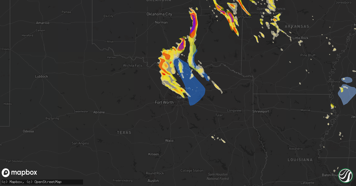
Hail Map on May 15, 2022
Get this storm
May 15 map
$229
one time, instant access
Download today. No call, no setup
Keep the $229
Bought the map and want the full workflow? Apply the entire $229 to a subscription within 7 days. None of it is wasted.
Every map, not just this one
This buys you this map. Subscription and you get every map we run, in the markets you choose from a few cities to whole states to nationwide. Plus real-time alerts the moment a storm fires.
Contact data
Name, contact info, occupancy, even credit band for addresses in the footprint. You go from where it hit to who to call.
Become the source they trust
Unlimited branding weather history reports on demand. You already have the documented answer ready for the property owner, and you are the one who showed up with it.
Property data and RoofTrace estimates
Pull up any address you have got, its value and the exact code rules for that jurisdiction, straight from One Click Code. Then RoofTrace estimates the squares, pitch, and roof value, priced the way you price.
States Impacted by Hail Map on May 15, 2022
Storm reports
New York
| Date | Description |
|---|---|
| 05/15/20223:55 PM CDT | Route 20 eb/wb closed at jefferson hill rd due to downed tree and wires. |
| 05/15/20222:55 PM CDT | Large tree limbs and wires down. |
| 05/15/20222:48 PM CDT | One tree down on park place ave. |
| 05/14/202210:52 PM CDT | At 351 PM EDT, a severe thunderstorm was located near Voorheesville, or near Delmar, moving southeast at 35 mph. HAZARD...60 mph wind gusts and quarter size hail. SOURCE...Radar indicated. IMPACT...Hail damage to vehicles is expected. Expect wind damage to roofs, siding, and trees. Locations impacted include... New Baltimore, Ravena, Feura Bush, Coeymans, Clarksville, Coeymans Hollow, East Berne, South Albany, Spawn Hollow, Dormansville, Callanans Corners, Keefers Corners, Reidsville, Bethlehem Heights, Hannacroix, Bramans Corners, New Salem, Helderberg, South Bethlehem and Medway. |
| 05/14/202210:39 PM CDT | At 339 PM EDT, a severe thunderstorm was located near Erin, or 10 miles northwest of Waverly, moving east at 15 mph. HAZARD...60 mph wind gusts and quarter size hail. SOURCE...Radar indicated. IMPACT...Hail damage to vehicles is expected. Expect wind damage to roofs, siding, and trees. Locations impacted include... Barton, Owego, Erin, Van Etten, Nichols, Lockwood, Tioga Center, Lounsberry, Owens Mill and Catatonk. |
| 05/14/202210:31 PM CDT | At 331 PM EDT, severe thunderstorms were located along a line extending from Clifton Park to Schenectady to Altamont, moving southeast at 35 mph. HAZARD...60 mph wind gusts. SOURCE...Radar indicated. IMPACT...Expect damage to roofs, siding, and trees. Locations impacted include... Albany, Schenectady, Troy, Clifton Park, Rotterdam, East Greenbush, Cohoes, Watervliet, Rensselaer, Colonie, Scotia, Delmar, Latham, Guilderland, Niskayuna, Menands, Voorheesville, Green Island, Waterford and Altamont. |
Illinois
| Date | Description |
|---|---|
| 05/15/20223:54 PM CDT | Videos show a brief tornado touched down west of salem... Il in empty field. Duration likely less than 1 minute... No damage or injuries. |
| 05/15/20221:03 AM CDT | At 602 PM CDT, a severe thunderstorm was located over Lovelaceville, or 9 miles west of Lone Oak, moving northeast at 35 mph. HAZARD...60 mph wind gusts. SOURCE...Radar indicated. IMPACT...Expect damage to roofs, siding, and trees. This severe thunderstorm will be near... Barkley Regional Airport around 610 PM CDT. Paducah, Lone Oak and West Paducah around 615 PM CDT.Other locations in the path of this severe thunderstorm includeReidland.This includes Interstate 24 in Kentucky between Mile Markers 1 and17. |
| 05/14/202211:31 PM CDT | At 431 PM CDT, a severe thunderstorm was located over Iola, or 13 miles northwest of Flora, moving east at 15 mph. HAZARD...60 mph wind gusts and quarter size hail. SOURCE...Radar indicated. IMPACT...Hail damage to vehicles is expected. Expect wind damage to roofs, siding, and trees. Locations impacted include... Bible Grove. |
| 05/14/202210:49 PM CDT | At 349 PM CDT, a severe thunderstorm was located near Bible Grove, or 15 miles north of Flora, moving east at 10 mph. HAZARD...60 mph wind gusts and quarter size hail. SOURCE...Radar indicated. IMPACT...Hail damage to vehicles is expected. Expect wind damage to roofs, siding, and trees. This severe thunderstorm will be near... Bible Grove around 405 PM CDT.This includes Interstate 57 between mile markers 143 and 144. |
| 05/14/202210:47 PM CDT | At 346 PM CDT, a severe thunderstorm was located near Martinsville, or 11 miles west of Marshall, moving northeast at 15 mph. HAZARD...60 mph wind gusts and quarter size hail. SOURCE...Radar indicated. IMPACT...Hail damage to vehicles is expected. Expect wind damage to roofs, siding, and trees. Locations impacted include... Clarksville.This includes Interstate 70 between mile markers 127 and 144. |
| 05/14/202210:35 PM CDT | At 335 PM CDT, severe thunderstorms were located along a line extending from near Chester to near Womac, moving east at 20 mph. HAZARD...60 mph wind gusts and quarter size hail. SOURCE...Radar indicated. IMPACT...Hail damage to vehicles is expected. Expect wind damage to roofs, siding, and trees. Locations impacted include... Perryville.This includes Interstate 55 between Mile Markers 124 and 137. |
Pennsylvania
| Date | Description |
|---|---|
| 05/15/20222:00 PM CDT | Trees and wires down on the 6000 block of cumberland highway. Time estimated by radar. |
| 05/15/20221:50 PM CDT | Half dollar size hail recorded on video in upper strasburg. Time estimated from radar. |
| 05/14/202210:32 PM CDT | At 331 PM EDT, severe thunderstorms were located along a line extending from Mount Holly Springs to Pine Grove Furnace, moving east at 5 mph. HAZARD...60 mph wind gusts and quarter size hail. SOURCE...Radar indicated. IMPACT...Hail damage to vehicles is expected. Expect wind damage to roofs, siding, and trees. Locations impacted include... Dillsburg, Lake Meade, Mount Holly Springs, Aspers, Pine Grove Furnace, Biglerville, York Springs, Heidlersburg, Bendersville, Franklintown, Wellsville and Idaville. |
| 05/14/20229:47 PM CDT | At 246 PM EDT, a severe thunderstorm was located over Upper Strasburg, moving east at 20 mph. HAZARD...60 mph wind gusts and quarter size hail. SOURCE...Radar indicated. IMPACT...Hail damage to vehicles is expected. Expect wind damage to roofs, siding, and trees. Locations impacted include... Chambersburg, Shippensburg, Scotland, Pine Grove Furnace, Upper Strasburg, Roxbury, Willow Hill, Walnut Bottom, Fannettsburg, Orrstown and Shippensburg University.This includes the following Interstates... The Pennsylvania Turnpike from mile markers 187 to 203. Interstate 81 from mile markers 18 to 38. |
South Carolina
| Date | Description |
|---|---|
| 05/15/20222:06 AM CDT | At 706 PM EDT, a severe thunderstorm was located near Pamplico, or 15 miles northeast of Lake City, moving north at 5 mph. HAZARD...60 mph wind gusts and quarter size hail. SOURCE...Radar indicated. IMPACT...Minor hail damage to vehicles is possible. Expect wind damage to trees and power lines. Locations impacted include... Pamplico. |
Oklahoma
| Date | Description |
|---|---|
| 05/15/20226:59 PM CDT | Camper overturned along roadway. |
| 05/15/20226:59 PM CDT | A local report indicates 2.20 inch wind near 1 E ATWOOD |
| 05/15/20226:52 PM CDT | A local report indicates 2.00 inch wind near FITTSTOWN |
| 05/15/20226:50 PM CDT | A local report indicates 1.75 inch wind near GERTY |
| 05/15/20226:49 PM CDT | A local report indicates 1.75 inch wind near 4 W SHADY POINT |
| 05/15/20226:47 PM CDT | A local report indicates 2.50 inch wind near ATWOOD |
| 05/15/20226:46 PM CDT | Report relayed by tv media. |
| 05/15/20226:44 PM CDT | A local report indicates 1.50 inch wind near CALVIN |
| 05/15/20226:44 PM CDT | A local report indicates 1.00 inch wind near 4 SW BROKEN ARROW |
| 05/15/20226:40 PM CDT | Roof blown off a building. Time estimated from radar. |
| 05/15/20226:34 PM CDT | A local report indicates 1.75 inch wind near 5 S ADA |
| 05/15/20226:23 PM CDT | A local report indicates 2.00 inch wind near 4 S ADA |
| 05/15/20226:19 PM CDT | A local report indicates 1.00 inch wind near 4 E ADA |
| 05/15/20226:16 PM CDT | Report via twitter. Time estimated via radar. |
| 05/15/20226:15 PM CDT | A local report indicates 3.00 inch wind near 4 S WETUMKA |
| 05/15/20226:15 PM CDT | A local report indicates 68 MPH wind near 3 ESE HOLDENVILLE |
| 05/15/20226:11 PM CDT | A local report indicates 2.50 inch wind near 1 S WETUMKA |
| 05/15/20226:07 PM CDT | Report via twitter. Relayed by local media. |
| 05/15/20225:57 PM CDT | A local report indicates 1.25 inch wind near BOKOSHE |
| 05/15/20225:57 PM CDT | A local report indicates 1.75 inch wind near 2 E WETUMKA |
| 05/15/20225:52 PM CDT | A local report indicates 1.00 inch wind near 3 ESE WEBBERS FALLS |
| 05/15/20225:46 PM CDT | A local report indicates 2.50 inch wind near GORE |
| 05/15/20225:46 PM CDT | Corrects previous hail report from keota. Report relayed by tv media. |
| 05/15/20225:35 PM CDT | Report from mping: tennis ball |
| 05/15/20225:33 PM CDT | Report via twitter. |
| 05/15/20225:33 PM CDT | Corrects previous hail report from 3 w clearview. Report via twitter measured 2.97 inches with calipers. |
| 05/15/20225:30 PM CDT | A local report indicates 4.50 inch wind near 2 SSE OKEMAH |
| 05/15/20225:27 PM CDT | A local report indicates 2.50 inch wind near 1 E OKEMAH |
| 05/15/20225:04 PM CDT | A local report indicates 2.00 inch wind near 4 NNE KEEFETON |
| 05/15/20225:01 PM CDT | Report from mping: golf ball |
| 05/15/20224:34 PM CDT | A local report indicates 1.00 inch wind near 7 NNW COOKSON |
| 05/15/20224:28 PM CDT | A local report indicates 1.00 inch wind near MUSKOGEE |
| 05/15/20224:23 PM CDT | Report via twitter from the media. |
| 05/15/20222:52 PM CDT | Report via twitter by media. Time estimated by radar. |
| 05/15/20227:28 AM CDT | At 1227 AM CDT, a severe thunderstorm was located 9 miles southeast of Ponca City, moving east at 25 mph. HAZARD...Golf ball size hail and 60 mph wind gusts. SOURCE...Radar indicated. IMPACT...People and animals outdoors will be injured. Expect hail damage to roofs, siding, windows, and vehicles. Expect wind damage to roofs, siding, and trees. Locations in or near the path include... Fairfax... Ralston... Burbank... Skedee... |
| 05/15/20227:18 AM CDT | At 1218 AM CDT, a severe thunderstorm was located 4 miles northeast of Marland, moving southeast at 20 mph. HAZARD...Golf ball size hail. SOURCE...Radar indicated. IMPACT...People and animals outdoors will be injured. Expect damage to roofs, siding, windows, and vehicles. Locations impacted include... Marland. |
| 05/15/20227:08 AM CDT | At 1206 AM CDT, severe thunderstorms were located along a line extending from near Ponca City to Carney, moving east at 30 mph. HAZARD...60 mph wind gusts and quarter size hail. SOURCE...Radar indicated. IMPACT...Hail damage to vehicles is expected. Expect wind damage to roofs, siding, and trees. Locations in or near the path include... Pawnee... Fairfax... Ralston... Burbank... Maramec... Skedee... Apperson... |
| 05/15/20226:48 AM CDT | At 1148 PM CDT, a severe thunderstorm was located near Leon, or 15 miles southwest of Marietta, moving southeast at 25 mph. HAZARD...Quarter size hail. SOURCE...Radar indicated. IMPACT...Damage to vehicles is possible. Locations impacted include... Gainesville, Lindsay and Callisburg. This includes Interstate 35 between mile markers 491 and 503. |
| 05/15/20225:12 AM CDT | At 1011 PM CDT, a pair of severe thunderstorms were located along a line extending from near Callisburg to near Muenster, moving southeast at 30 mph. HAZARD...Golf ball size hail and 60 mph wind gusts. SOURCE...Radar indicated. IMPACT...People and animals outdoors will be injured. Expect hail damage to roofs, siding, windows, and vehicles. Expect wind damage to roofs, siding, and trees. Locations impacted include... Gainesville, Whitesboro, Pilot Point, Collinsville, Muenster, Gunter, Lindsay, Callisburg, Dorchester, Ray Roberts Park Johnson Branch, Lake Kiowa, southwestern Lake Texoma, Southmayd, Tioga, Valley View and Sadler.This includes Interstate 35 between mile markers 482 and 503. |
| 05/15/20224:37 AM CDT | At 937 PM CDT, severe thunderstorms were located along a line extending from 7 miles southeast of Bennington to near Kemp to 4 miles northeast of Thackerville to near Rubottom, moving south at 25 mph. HAZARD...Two inch hail and 60 mph wind gusts. SOURCE...Radar indicated. IMPACT...People and animals outdoors will be injured. Expect hail damage to roofs, siding, windows, and vehicles. Expect wind damage to roofs, siding, and trees. Locations impacted include... Durant, Marietta, Kingston, Colbert, Achille, Thackerville, Kemp, Leon, Hendrix, Cartwright, Rubottom, Woodville, Utica, Burneyville, Lebanon, Willis, Lake Texoma, Albany, Calera and Wade. |
| 05/15/20224:13 AM CDT | At 913 PM CDT, a severe thunderstorm was located 6 miles northwest of Rubottom, moving south at 20 mph. HAZARD...Two inch hail and 60 mph wind gusts. SOURCE...Radar indicated. IMPACT...People and animals outdoors will be injured. Expect hail damage to roofs, siding, windows, and vehicles. Expect wind damage to roofs, siding, and trees. Locations impacted include... Leon, Rubottom, Courtney and Petersburg. |
| 05/15/20223:56 AM CDT | At 855 PM CDT, severe thunderstorms were located along a line extending from near Utica to near Wilson, moving south at 25 mph. HAZARD...Golf ball size hail and 70 mph wind gusts. SOURCE...Trained weather spotters. IMPACT...People and animals outdoors will be injured. Expect hail damage to roofs, siding, windows, and vehicles. Expect considerable tree damage. Wind damage is also likely to mobile homes, roofs, and outbuildings. Locations impacted include... Sherman, Denison, Gainesville, Bonham, Whitesboro, Pottsboro, Honey Grove, Muenster, Bells, St. Jo, Lindsay, Savoy, Ector, Dodd City, Callisburg, Knollwood, Ravenna, Bonham State Park, southern Lake Texoma and Eisenhower State Park.This includes Interstate 35 between mile markers 496 and 503. |
| 05/15/20223:42 AM CDT | At 841 PM CDT, severe thunderstorms were located along a line extending from 4 miles northeast of Bennington to near Durant to near Kingston to near Lake Murray to near Wilson, moving southeast at 30 mph. HAZARD...Two inch hail and 70 mph wind gusts. SOURCE...Radar indicated. IMPACT...People and animals outdoors will be injured. Expect hail damage to roofs, siding, windows, and vehicles. Expect considerable tree damage. Wind damage is also likely to mobile homes, roofs, and outbuildings. Locations impacted include... Ardmore, Durant, Madill, Atoka, Tishomingo, Marietta, Lone Grove, Healdton, Wilson, Kingston, Dickson, Colbert, Caddo, Mannsville, Springer, Bokchito, Ravia, Achille, Thackerville and Wapanucka. |
| 05/15/20223:19 AM CDT | At 818 PM CDT, a severe thunderstorm was located 4 miles southwest of Milo, moving southeast at 25 mph. HAZARD...Two inch hail and 60 mph wind gusts. SOURCE...Radar indicated. IMPACT...People and animals outdoors will be injured. Expect hail damage to roofs, siding, windows, and vehicles. Expect wind damage to roofs, siding, and trees. Locations impacted include... Lone Grove, Healdton, Wilson and Graham. |
| 05/15/20222:49 AM CDT | At 749 PM CDT, a severe thunderstorm was located near Keefeton, moving southeast at 30 mph. HAZARD...60 mph wind gusts and quarter size hail. SOURCE...Radar indicated. IMPACT...Hail damage to vehicles is expected. Expect wind damage to roofs, siding, and trees. Locations in or near the path include... Muskogee... Keefeton... |
| 05/15/20222:18 AM CDT | At 718 PM CDT, a severe thunderstorm was located 3 miles south of Tullahassee, moving southeast at 30 mph. HAZARD...Ping pong ball size hail and 60 mph wind gusts. SOURCE...Radar indicated. IMPACT...People and animals outdoors will be injured. Expect hail damage to roofs, siding, windows, and vehicles. Expect wind damage to roofs, siding, and trees. Locations in or near the path include... Muskogee... Taft... Keefeton... Summit... |
| 05/15/20222:16 AM CDT | At 716 PM CDT, severe thunderstorms were located along a line extending from 4 miles northwest of Wardville to near Centrahoma to 3 miles northwest of Pontotoc to 5 miles southeast of Lake Of The Arbuckles, moving south at 25 mph. HAZARD...Two inch hail and 70 mph wind gusts. SOURCE...Radar indicated. IMPACT...People and animals outdoors will be injured. Expect hail damage to roofs, siding, windows, and vehicles. Expect considerable tree damage. Wind damage is also likely to mobile homes, roofs, and outbuildings. Locations impacted include... Sulphur, Atoka, Tishomingo, Coalgate, Dickson, Mannsville, Ravia, Stonewall, Wapanucka, Stringtown, Lehigh, Tupelo, Mill Creek, Milburn, Bromide, Gerty, Centrahoma, Hickory, Clarita and Olney. |
| 05/15/20222:09 AM CDT | At 709 PM CDT, a severe thunderstorm was located near Hickory, moving southeast at 25 mph. HAZARD...60 mph wind gusts and half dollar size hail. SOURCE...Radar indicated. IMPACT...Hail damage to vehicles is expected. Expect wind damage to roofs, siding, and trees. Locations impacted include... Roff, Hickory and Scullin. |
| 05/15/20221:59 AM CDT | At 659 PM CDT, severe thunderstorms were located along a line extending from 7 miles north of Wagoner to 4 miles south of Sportsmen Acres Community, moving southeast at 20 mph. HAZARD...60 mph wind gusts and half dollar size hail. SOURCE...Radar indicated. IMPACT...Hail damage to vehicles is expected. Expect wind damage to roofs, siding, and trees. Locations in or near the path include... Tahlequah... Chouteau... Locust Grove... Hulbert... Peggs... Sportsmen Acres Community... Lost City... Mazie... Murphy... |
| 05/15/20221:56 AM CDT | At 656 PM CDT, a severe thunderstorm was located near Lake Of The Arbuckles, moving southeast at 25 mph. HAZARD...60 mph wind gusts and half dollar size hail. SOURCE...Radar indicated. IMPACT...Hail damage to vehicles is expected. Expect wind damage to roofs, siding, and trees. Locations impacted include... Sulphur, Davis, Mill Creek, Lake Of The Arbuckles, Reagan and Connerville. |
| 05/15/20221:47 AM CDT | At 647 PM CDT, a severe thunderstorm was located near Gerty, moving south at 20 mph. THIS IS A DESTRUCTIVE STORM FOR southern Hughes county. HAZARD...Three inch hail and 70 mph wind gusts. SOURCE...Radar indicated. IMPACT...People and animals outdoors will be severely injured. Expect shattered windows, extensive damage to roofs, siding, and vehicles. Locations impacted include... Holdenville, Calvin, Stuart, Lamar, Gerty, Horntown and Atwood. |
| 05/15/20221:45 AM CDT | At 645 PM CDT, a severe thunderstorm was located 4 miles southwest of Bokoshe, moving southeast at 30 mph. HAZARD...60 mph wind gusts and half dollar size hail. SOURCE...Radar indicated. IMPACT...Hail damage to vehicles is expected. Expect wind damage to roofs, siding, and trees. Locations in or near the path include... Poteau... Wister... Howe... Mccurtain... Bokoshe... Lake Wister State Park... Mc Curtain... Milton... |
| 05/15/20221:38 AM CDT | At 638 PM CDT, a severe thunderstorm was located near Fittstown, moving southeast at 20 mph. HAZARD...Two inch hail and 60 mph wind gusts. SOURCE...Radar indicated. IMPACT...People and animals outdoors will be injured. Expect hail damage to roofs, siding, windows, and vehicles. Expect wind damage to roofs, siding, and trees. Locations impacted include... Ada, Stonewall, Tupelo, Bromide, Centrahoma, Pontotoc, Fittstown, Clarita and Jesse. |
| 05/15/20221:36 AM CDT | At 636 PM CDT, severe thunderstorms were located along a line extending from near Kiefer to 3 miles southwest of Broken Arrow to 5 miles south of Inola, moving southeast at 20 mph. HAZARD...60 mph wind gusts and quarter size hail. SOURCE...Radar indicated. IMPACT...Hail damage to vehicles is expected. Expect wind damage to roofs, siding, and trees. Locations in or near the path include... Tulsa... Broken Arrow... Wagoner... Bixby... Sapulpa... Jenks... Glenpool... Coweta... Haskell... Inola... Kiefer... Mounds... Okay... Hulbert... Porter... Tullahassee... Jenks Riverside Airport... Stonebluff... Sequoyah State Park... Oneta...This includes Interstate 44 between mile markers 205 and 206, andbetween mile markers 208 and 211. |
| 05/15/20221:09 AM CDT | At 609 PM CDT, a severe thunderstorm was located near Lamar, moving southeast at 25 mph. HAZARD...Two inch hail and 70 mph wind gusts. SOURCE...Radar indicated. IMPACT...People and animals outdoors will be injured. Expect hail damage to roofs, siding, windows, and vehicles. Expect considerable tree damage. Wind damage is also likely to mobile homes, roofs, and outbuildings. Locations impacted include... Wetumka, Dustin, Calvin, Stuart, Lamar, Horntown, Yeager and Atwood. |
| 05/15/20221:05 AM CDT | At 605 PM CDT, a severe thunderstorm was located over Tamaha, moving southeast at 30 mph. HAZARD...60 mph wind gusts and half dollar size hail. SOURCE...Radar indicated. IMPACT...Hail damage to vehicles is expected. Expect wind damage to roofs, siding, and trees. Locations in or near the path include... Spiro... Vian... Keota... Mccurtain... Bokoshe... Tamaha... Mc Curtain... Cowlington... Kanima... Milton...This includes Interstate 40 in Oklahoma between mile markers 294 and300. |
| 05/15/20221:05 AM CDT | At 605 PM CDT, a severe thunderstorm was located 5 miles south of Ada, moving east at 25 mph. HAZARD...60 mph wind gusts and quarter size hail. SOURCE...Radar indicated. IMPACT...Hail damage to vehicles is expected. Expect wind damage to roofs, siding, and trees. Locations impacted include... Ada, Stonewall, Tupelo, Fitzhugh, Fittstown and Jesse. |
| 05/15/202212:27 AM CDT | At 527 PM CDT, a severe thunderstorm was located 5 miles northwest of Webbers Falls, moving southeast at 20 mph. HAZARD...60 mph wind gusts and half dollar size hail. SOURCE...Radar indicated. IMPACT...Hail damage to vehicles is expected. Expect wind damage to roofs, siding, and trees. Locations in or near the path include... Warner... Gore... Webbers Falls... Braggs... Tamaha... Greenleaf State Park... Keefeton... This includes Interstate 40 in Oklahoma between mile markers 277 and295. |
| 05/15/202212:25 AM CDT | At 525 PM CDT, a severe thunderstorm was located 4 miles west of Weleetka, moving south at 30 mph. HAZARD...Two inch hail and 70 mph wind gusts. SOURCE...Radar indicated. IMPACT...People and animals outdoors will be injured. Expect hail damage to roofs, siding, windows, and vehicles. Expect considerable tree damage. Wind damage is also likely to mobile homes, roofs, and outbuildings. Locations impacted include... Wetumka, Dustin, Calvin, Lamar, Horntown, Yeager and Atwood. |
| 05/15/202212:22 AM CDT | At 521 PM CDT, a severe thunderstorm was located over Okemah, moving southeast at 25 mph. HAZARD...Two inch hail and 70 mph wind gusts. SOURCE...Radar indicated. IMPACT...People and animals outdoors will be injured. Expect hail damage to roofs, siding, windows, and vehicles. Expect considerable tree damage. Wind damage is also likely to mobile homes, roofs, and outbuildings. Locations in or near the path include... Okemah... Boley... Weleetka... Hanna... Bearden... Castle... Clearview... Pharoah... Bryant... Vernon...This includes Interstate 40 in Oklahoma between mile markers 213 and235. |
| 05/14/202211:56 PM CDT | At 456 PM CDT, a severe thunderstorm was located 3 miles east of Vian, moving southeast at 20 mph. HAZARD...60 mph wind gusts and half dollar size hail. SOURCE...Radar indicated. IMPACT...Hail damage to vehicles is expected. Expect wind damage to roofs, siding, and trees. Locations in or near the path include... Sallisaw... Muldrow... Vian... Gans... Marble City... Tamaha... Brushy Lake State Park... Mc Key...This includes Interstate 40 in Oklahoma between mile markers 292 and318. |
| 05/14/202211:46 PM CDT | At 445 PM CDT, a severe thunderstorm was located near Okmulgee State Park, moving southeast at 25 mph. HAZARD...60 mph wind gusts and quarter size hail. SOURCE...Radar indicated. IMPACT...Hail damage to vehicles is expected. Expect wind damage to roofs, siding, and trees. Locations in or near the path include... Okmulgee... Morris... Schulter... Grayson... Okmulgee State Park... |
| 05/14/202211:32 PM CDT | At 431 PM CDT, a severe thunderstorm was located over Muskogee, moving southeast at 30 mph. HAZARD...60 mph wind gusts and quarter size hail. SOURCE...Radar indicated. IMPACT...Hail damage to vehicles is expected. Expect wind damage to roofs, siding, and trees. Locations in or near the path include... Muskogee... Fort Gibson... Vian... Gore... Webbers Falls... Braggs... Greenleaf State Park... Lake Tenkiller State Park... Keefeton... Summit...This includes Interstate 40 in Oklahoma between mile markers 280 and294. |
| 05/14/202211:24 PM CDT | At 423 PM CDT, a severe thunderstorm was located 3 miles east of Welty, moving southeast at 30 mph. HAZARD...60 mph wind gusts and quarter size hail. SOURCE...Radar indicated. IMPACT...Hail damage to vehicles is expected. Expect wind damage to roofs, siding, and trees. Locations in or near the path include... Okemah... Okfuskee... Henryetta... Weleetka... Dewar... Clearview... Welty... Pharoah... Bryant... Mason...This includes Interstate 40 in Oklahoma between mile markers 220 and237. |
| 05/14/202211:18 PM CDT | At 418 PM CDT, severe thunderstorms were located along a line extending from 7 miles north of Bunch to 2 miles northwest of Cherokee Landing State Park, moving southeast at 20 mph. HAZARD...60 mph wind gusts and quarter size hail. SOURCE...Radar indicated. IMPACT...Hail damage to vehicles is expected. Expect wind damage to roofs, siding, and trees. Locations in or near the path include... Stilwell... Marble City... Bunch... Cookson... Brushy... Cherokee Landing State Park... |
| 05/14/202210:33 PM CDT | A local report indicates 1.75 inch wind near BURNEYVILLE |
| 05/14/202210:10 PM CDT | At 310 PM CDT, a severe thunderstorm was located 7 miles east of Adair State Park, moving southeast at 25 mph. HAZARD...Ping pong ball size hail and 60 mph wind gusts. SOURCE...Radar indicated. IMPACT...People and animals outdoors will be injured. Expect hail damage to roofs, siding, windows, and vehicles. Expect wind damage to roofs, siding, and trees. Locations in or near the path include... Stilwell... Cedarville... Mountainburg... Natural Dam... Chester... Rudy... Devils Den State Park... Lake Fort Smith... Strickler... Figure Five... Lee Creek... Clyde... Locke... Odell... Morrow... This includes Interstate 49 between mile markers 25 and 41. |
| 05/14/20229:49 PM CDT | At 249 PM CDT, a severe thunderstorm was located over Baron, moving southeast at 20 mph. HAZARD...60 mph wind gusts and half dollar size hail. SOURCE...Radar indicated. IMPACT...Hail damage to vehicles is expected. Expect wind damage to roofs, siding, and trees. Locations in or near the path include... Stilwell... Westville... Adair State Park... Christie... Baron... Maryetta... Odell... Morrow... |
| 05/14/20229:25 PM CDT | Numerous powerlines and trees down across the city of durant. |
| 05/14/20229:21 PM CDT | At 219 AM CDT, a severe thunderstorm was located 4 miles south of Inola, moving east at 50 mph. HAZARD...60 mph wind gusts and quarter size hail. SOURCE...Radar indicated. IMPACT...Hail damage to vehicles is expected. Expect wind damage to roofs, siding, and trees. Locations in or near the path include... Coweta... Chouteau... Inola... Locust Grove... Sportsmen Acres Community... Mazie... Murphy... |
| 05/14/20228:55 PM CDT | A local report indicates 70 MPH wind near 5 NW LEBANON |
| 05/14/20228:52 PM CDT | A local report indicates 1.00 inch wind near 2 N DURANT |
| 05/14/20228:50 PM CDT | Transformer blown. |
| 05/14/20228:50 PM CDT | Corrects time from previous tstm wnd dmg report from durant. Numerous powerlines and trees down across the city of durant. |
| 05/14/20228:45 PM CDT | Power lines down. |
| 05/14/20228:43 PM CDT | At 142 AM CDT, a severe thunderstorm was located over Pensacola, moving northeast at 25 mph. HAZARD...60 mph wind gusts and half dollar size hail. SOURCE...Radar indicated. IMPACT...Hail damage to vehicles is expected. Expect wind damage to roofs, siding, and trees. Locations in or near the path include... Grove... Langley... Bernice... Ketchum... Spavinaw... Disney... Big Cabin... Pensacola... Hoot Owl... Honey Creek State Park... Cherokee State Park... Bernice State Park... Spavinaw State Park... Cleora... Chloeta... Strang... Disney Little Blue State Park... Zena... |
| 05/14/20228:35 PM CDT | A local report indicates 70 MPH wind near 2 N DURANT |
| 05/14/20228:35 PM CDT | Trees blown down. |
| 05/14/20228:35 PM CDT | Large trees snapped off and missing shingles. |
| 05/14/20228:33 PM CDT | Approx. 3 to 4 inch diameter tree limbs being torn off trees. |
| 05/14/20228:30 PM CDT | Trees down on the south side of town. |
| 05/14/20228:27 PM CDT | A local report indicates 1.00 inch wind near GENE AUTRY |
| 05/14/20228:20 PM CDT | A local report indicates 1.75 inch wind near 5 S MILO |
| 05/14/20228:15 PM CDT | A local report indicates 1.50 inch wind near 1 E SPRINGER |
| 05/14/20228:07 PM CDT | At 107 AM CDT, a severe thunderstorm was located near Pryor, moving northeast at 15 mph. HAZARD...60 mph wind gusts and half dollar size hail. SOURCE...Radar indicated. IMPACT...Hail damage to vehicles is expected. Expect wind damage to roofs, siding, and trees. Locations in or near the path include... Pryor... Pryor Creek... Langley... Adair... Spavinaw... Big Cabin... Pensacola... Hoot Owl... Cherokee State Park... Spavinaw State Park... Sportsmen Acres Community... Strang... Snowdale State Park... This includes Interstate 44 between mile markers 261 and 280. |
| 05/14/20228:06 PM CDT | A local report indicates 1.00 inch wind near SPRINGER |
| 05/14/20227:38 PM CDT | Report from mping: ping pong ball |
| 05/14/20227:35 PM CDT | A local report indicates 1.25 inch wind near 5 ESE LAKE OF THE ARBUC |
| 05/14/20227:31 PM CDT | Report from mping: quarter |
| 05/14/20227:30 PM CDT | A local report indicates 1.50 inch wind near 1 NNE DOUGHERTY |
| 05/14/20227:25 PM CDT | A local report indicates 2.25 inch wind near PONTOTOC |
| 05/14/20227:25 PM CDT | A local report indicates 1.00 inch wind near 2 NW TUPELO |
| 05/14/20227:15 PM CDT | Several trees blown down. |
| 05/14/20227:12 PM CDT | Corrects previous tstm wnd dmg report from 2 e fittstown. |
| 05/14/20227:10 PM CDT | Report via twitter. |
| 05/14/20227:00 PM CDT | Dime to golf ball size hail relayed by ham radio operator. |
Oregon
| Date | Description |
|---|---|
| 05/15/20226:40 PM CDT | Hail ranged in size from 3/4 to 1 inch and was up to 1.5 inches deep. |
| 05/15/20226:40 PM CDT | Reported along i-84 at exit 234. |
| 05/15/20226:40 PM CDT | Corrects previous report 13 se mission. Located at exit 234 on i-84. |
| 05/15/20226:40 PM CDT | Corrected for more accurate location. Located at exit 234 on i-84. |
| 05/15/20221:39 AM CDT | Corrects previous report 13 se mission. Located at exit 234 on i-84. |
| 05/15/202212:02 AM CDT | At 502 PM PDT, a severe thunderstorm was located 9 miles south of Spout Springs, or 16 miles northeast of Meacham, moving northeast at 55 mph. HAZARD...60 mph wind gusts and half dollar size hail. SOURCE...Radar indicated. IMPACT...Hail damage to vehicles is expected. Expect wind damage to roofs, siding, and trees. Locations impacted include... Troy. |
| 05/14/202211:35 PM CDT | At 434 PM PDT, a severe thunderstorm was located over northwestern Umatilla Reservation, or 10 miles southeast of Pendleton, moving northeast at 45 mph. HAZARD...Ping pong ball size hail and 60 mph wind gusts. SOURCE...Radar indicated. IMPACT...People and animals outdoors will be injured. Expect hail damage to roofs, siding, windows, and vehicles. Expect wind damage to roofs, siding, and trees. Locations impacted include... Pendleton, Thorn Hollow, Tollgate, Spout Springs, Cayuse, Umatilla Reservation, Bingham Springs, Mission and Gibbon. |
Alabama
| Date | Description |
|---|---|
| 05/15/20224:51 PM CDT | Nws employee reports hail ranging from pea to quarter size. Ongoing at time of report. |
| 05/15/20224:50 PM CDT | Quarter to half dollar sized hail on memphis way in robertsdale... Al. |
| 05/15/20224:50 PM CDT | Quarter sized hail fell from 450-458 pm and resumed at 507 pm. |
| 05/15/20224:20 PM CDT | Reported along gary springs rd. |
| 05/15/20224:18 PM CDT | Reported along river bend rd. |
| 05/15/20225:39 AM CDT | At 1039 PM CDT, severe thunderstorms were located along a line extending from near Axis to 6 miles north of Wilmer, moving south at 20 mph. HAZARD...60 mph wind gusts. SOURCE...Radar indicated. IMPACT...Expect damage to roofs, siding, and trees. Locations impacted include... Midtown Mobile, Downtown Mobile, Prichard, Tillmans Corner, Saraland, Chickasaw, Satsuma, Spanish Fort, Creola, Chunchula, Stapleton, Axis, Semmes, Tanner Williams, I65 And I165, Mobile Regional Airport, Wilmer, I65 And AL 158 and I10 And I65. |
| 05/15/20222:40 AM CDT | At 740 PM CDT, a severe thunderstorm was located 5 miles northeast of Toxey, or 10 miles south of Butler, moving southeast at 15 mph. HAZARD...60 mph wind gusts and quarter size hail. SOURCE...Radar indicated. IMPACT...Hail damage to vehicles is expected. Expect wind damage to roofs, siding, and trees. Locations impacted include... Coffeeville and Toxey. |
| 05/15/20222:36 AM CDT | At 735 PM CDT, a severe thunderstorm was located over Martin Dam, or 9 miles north of Tallassee, moving south at 25 mph. HAZARD...60 mph wind gusts and quarter size hail. SOURCE...Radar indicated. IMPACT...Hail damage to vehicles is expected. Expect wind damage to roofs, siding, and trees. Locations impacted include... Tuskegee, Tallassee, Franklin, Liberty City, Reeves Airport, Tallapoosa City, Yates Dam, Reeltown and Yates Reservoir. |
| 05/15/20222:30 AM CDT | At 730 PM CDT, a severe thunderstorm was located over Midtown Mobile, moving south at 15 mph. HAZARD...60 mph wind gusts and quarter size hail. SOURCE...Radar indicated. IMPACT...Hail damage to vehicles is expected. Expect wind damage to roofs, siding, and trees. Locations impacted include... Midtown Mobile, Downtown Mobile, Prichard, Tillmans Corner, Theodore and I10 And I65. |
| 05/15/20221:27 AM CDT | At 627 PM CDT, a severe thunderstorm was located over Loxley, moving southwest at 10 mph. HAZARD...60 mph wind gusts and quarter size hail. SOURCE...Radar indicated. IMPACT...Hail damage to vehicles is expected. Expect wind damage to roofs, siding, and trees. Locations impacted include... Daphne, Fairhope, Robertsdale, Loxley and Silverhill. |
| 05/15/202212:22 AM CDT | At 522 PM CDT, a severe thunderstorm was located near Crawford, or 15 miles southeast of Starkville, moving south at 25 mph. HAZARD...60 mph wind gusts and quarter size hail. SOURCE...Radar indicated. IMPACT...Hail damage to vehicles is expected. Expect wind damage to roofs, siding, and trees. This severe thunderstorm will be near... Crawford around 525 PM CDT. Brooksville and Deerbrook around 535 PM CDT. Macon around 555 PM CDT. |
| 05/14/202211:40 PM CDT | At 440 PM CDT, a severe thunderstorm was located over Summerdale, or near Robertsdale, and is nearly stationary. HAZARD...60 mph wind gusts and quarter size hail. SOURCE...Radar indicated. IMPACT...Hail damage to vehicles is expected. Expect wind damage to roofs, siding, and trees. Locations impacted include... Foley, Robertsdale, Loxley, Summerdale and Silverhill. |
| 05/14/202211:14 PM CDT | At 414 PM CDT, a severe thunderstorm was located near Centreville, moving south at 5 mph. HAZARD...60 mph wind gusts and quarter size hail. SOURCE...Radar indicated. IMPACT...Hail damage to vehicles is expected. Expect wind damage to roofs, siding, and trees. Locations impacted include... Brent, Centreville, West Centreville, Trio, Six Mile and Bibb County Airport. |
| 05/14/20229:59 PM CDT | At 259 PM CDT, a severe thunderstorm was located near Kennedy, or near Millport, moving southeast at 15 mph. HAZARD...60 mph wind gusts and quarter size hail. SOURCE...Radar indicated. IMPACT...Hail damage to vehicles is expected. Expect wind damage to roofs, siding, and trees. Locations impacted include... Vernon, Millport, Kennedy, Belk, Ashcraft Corner, Blooming Grove, Crossville, Cody, Star and Hightogy. |
| 05/14/20228:45 PM CDT | Quarter sized hail near mary montgomery school. Time estimated by radar. |
| 05/14/20228:39 PM CDT | Corrects previous hail report from 1 w semmes. Quarter sized hail near mary montgomery school. Time estimated by radar. |
| 05/14/20228:38 PM CDT | Hail estimated to be of quarter or half dollar size reported near glenwood hills drive in wilmer. |
| 05/14/20227:40 PM CDT | Tree and power line down along s central blvd. |
| 05/14/20227:40 PM CDT | Quarter sized hail report via social media. Time estimated by radar. |
| 05/14/20227:39 PM CDT | Tree down on macedonia rd near martin rd blocking the road. |
| 05/14/20227:00 PM CDT | Quarter sized hail report via social media. Time estimated by radar. |
Tennessee
| Date | Description |
|---|---|
| 05/15/20226:16 PM CDT | Estimated wind gusts of 60 mph with nickel-sized hail. |
| 05/15/20226:08 PM CDT | Quarter-sized hail observed along interstate 40 at mile marker 40. |
| 05/15/20225:35 PM CDT | A 63 mph wind gust measured at covington municipal airport. |
| 05/15/20225:19 PM CDT | A local report indicates 1.50 inch wind near 2 SE COVINGTON |
| 05/15/20224:42 PM CDT | A local report indicates 1.25 inch wind near TIPTONVILLE |
| 05/15/20223:15 PM CDT | Pea size hail reported by cocorahs station loretto 1.1 e. |
| 05/15/20221:25 AM CDT | At 624 PM CDT, severe thunderstorms were located along a line extending from near Dancyville to near Somerville to near Mt Pleasant, moving east at 25 mph. HAZARD...60 mph wind gusts and quarter size hail. SOURCE...Radar indicated. IMPACT...Hail damage to vehicles is expected. Expect wind damage to roofs, siding, and trees. Locations impacted include... Lamar, Whiteville, Somerville, Byhalia, Snow Lake Shores, Mt Pleasant, Hillville, Michigan City, Lagrange, Dancyville, Slayden, Warren, Macon, Oakland, Mason, Piperton, Rossville, Moscow, Stanton and Williston. |
| 05/15/202212:59 AM CDT | At 558 PM CDT, severe thunderstorms were located along a line extending from near Nutbush to 11 miles southwest of Brownsville to 9 miles west of Dancyville, moving east at 25 mph. HAZARD...60 mph wind gusts and quarter size hail. SOURCE...Radar indicated. IMPACT...Hail damage to vehicles is expected. Expect wind damage to roofs, siding, and trees. Locations impacted include... Brownsville, Somerville, Nutbush, Dancyville, Oakland, Mason, Henning, Gallaway, Stanton, Braden, Asbury, Yum Yum, Belmont, Christmasville, Hickory Point, Taylor Chapel, Shepp, Turnpike, Meux Corner and Cotton Lake. |
| 05/15/202212:32 AM CDT | At 532 PM CDT, a severe thunderstorm was located near Covington, moving east at 25 mph. HAZARD...Quarter size hail. SOURCE...Radar indicated. IMPACT...Damage to vehicles is expected. Locations impacted include... Covington, Stanton, Asbury, Cotton Lake, Canaan Grove, Orysa, Keeling, Gift, Shepp, Tabernacle, Clopton, Turnpike, Meux Corner and Rialto. |
| 05/14/202211:47 PM CDT | At 447 PM CDT, severe thunderstorms were located along a line extending from near Hunter-Dawson State Historic Site to near Reelfoot Lake State Park, moving northeast at 35 mph. HAZARD...60 mph wind gusts and quarter size hail. SOURCE...Radar indicated. IMPACT...Hail damage to vehicles is expected. Expect wind damage to roofs, siding, and trees. Severe thunderstorms will be near... Big Oak Tree State Park around 505 PM CDT.Other locations in the path of these severe thunderstorms includeHickman, Dorena, Towosahgy State Historic Site and Cayce.This includes Interstate 55 between Mile Markers 45 and 50. |
| 05/14/202211:43 PM CDT | At 443 PM CDT, a severe thunderstorm was located near Covington, moving southeast at 20 mph. HAZARD...Quarter size hail. SOURCE...Radar indicated. IMPACT...Damage to vehicles is expected. Locations impacted include... Brownsville, Covington, Ft Pillow, Mason, Henning, Stanton, Burlison, Garland, Cotton Lake, Canaan Grove, Orysa, Bride, Keeling, Gift, Three Point, Tabernacle, Turnpike, Glimp, Meux Corner and Rialto. |
Virginia
| Date | Description |
|---|---|
| 05/15/20225:22 PM CDT | Large tree limb down in the roadway on us-15/us-29 lee highway near va-605 colonial road/dumfries road. |
| 05/15/20225:22 PM CDT | Tree down near the intersection of snow hill drive and lee highway |
| 05/15/20221:06 AM CDT | At 605 PM EDT, a severe thunderstorm was located 7 miles south of Hume, or 11 miles west of Warrenton, moving east at 10 mph. HAZARD...Quarter size hail. SOURCE...Radar indicated. IMPACT...Some hail damage to agriculture is expected. Locations impacted include... Warrenton, New Baltimore, Opal, Flint Hill, Turnbull, Meadowville, Airlie, Hackleys Crossroads, Amissville, Cresthill, Orlean and Viewtown. |
Arkansas
| Date | Description |
|---|---|
| 05/15/20226:50 PM CDT | A tree was blown over a house on south cokley street. |
| 05/15/20226:50 PM CDT | Trees were down in lake village and around the county. |
| 05/15/20226:42 PM CDT | Recorded at private airport weather station. |
| 05/15/20226:40 PM CDT | At the pecan grove rv park on the south side of lake village... Several pecan trees were blown down or lost limbs. One tree fell onto an rv at the park... But no one wa |
| 05/15/20226:25 PM CDT | Big... Old hardwood trees were blown down around dermott. Blowing dust was also down to less than a quarter mile in the area before the rain started. Report relayed via |
| 05/15/20226:25 PM CDT | Trees and powerlines were blown down along highway 35. |
| 05/15/20226:23 PM CDT | A few tree limbs were blown down... And blowing dust was reported in the halley junction area. Report with video relayed via facebook. |
| 05/15/20226:15 PM CDT | Trees down south of the ua monticello campus |
| 05/15/20226:02 PM CDT | Trees down across the county |
| 05/15/20225:50 PM CDT | Trees blocking phillips st. |
| 05/15/20225:45 PM CDT | Trees down blocking alice st. |
| 05/15/20225:40 PM CDT | Trees down at kingsland |
| 05/15/20225:15 PM CDT | Asp reported a tree knocked over across hwy 54... Approx 4 miles west of hwy 79... Completely blocking the road...relayed by local em. Time is based on radar. |
| 05/15/20225:08 PM CDT | Social media picture of a large tree |
| 05/15/20225:02 PM CDT | A tree was reported down across manford rd. At caddo gap. |
| 05/15/20225:02 PM CDT | Social media picture of large pine tree that was knocked over onto a power line on grant co rd 606. Grant co sheriff's deputy was dispatched to the scene. Time is based |
| 05/15/20224:56 PM CDT | Local officials reported several trees and powerlines down near county club rd and floyd brown rd in brinkley. Time is based on radar data. |
| 05/15/20224:56 PM CDT | Local officials reported numerous trees and powerlines down across grant co. A tree was knocked over... Blocking hwy 46n in sheridan... W/ ar dot and sheridan fd dispat |
| 05/15/20224:44 PM CDT | Local em relayed that a business in poyen had sustained roof damage. |
| 05/15/20224:38 PM CDT | Trees down near east end |
| 05/15/20224:32 PM CDT | Trees were reported down in lonoke. |
| 05/15/20224:32 PM CDT | Social media picture of a tree that was blown onto an airstream trailer... Significantly damaging the trailer structure. No injuries were reported. Time is based on rad |
| 05/15/20224:32 PM CDT | Trees were reported down all around prairie county. A powerline was down on hwy. 302 in hazen. |
| 05/15/20224:26 PM CDT | Social media picture from the ashley downs subdivision... Showing a pontoon boat that had been blown away from it's original resting location into a drainage area behin |
| 05/15/20224:26 PM CDT | Downed trees at benton |
| 05/15/20224:26 PM CDT | Power lines were reported down all around garland county. A roof was blown off a storage building in the 6000 block of albert pike rd in hot springs. |
| 05/15/20224:26 PM CDT | Reports of multiple trees down on power lines in des arc... Relayed via nws chat. |
| 05/15/20224:14 PM CDT | Social media picture of a large tree |
| 05/15/20224:14 PM CDT | Trees down near owensville |
| 05/15/20224:11 PM CDT | A 50 knot peak wind gust was recorded at the little rock afb weather station. |
| 05/15/20224:10 PM CDT | A tree fell on a power line on north hills blvd. Just north of crestwood. |
| 05/15/20224:10 PM CDT | Photo of ping pong ball-sized hail just south of the clear lake area. |
| 05/15/20224:08 PM CDT | A large tree was knocked down... Partially blocking jacksonville-cato rd between gibson and gravel ridge. |
| 05/15/20224:08 PM CDT | Trees down at newport |
| 05/15/20224:08 PM CDT | Social media picture of a large tree |
| 05/15/20224:01 PM CDT | Report from mping: quarter |
| 05/15/20224:00 PM CDT | Report via twitter by media. |
| 05/15/20223:52 PM CDT | Report of large branches and a tree down on susan drive. |
| 05/15/20223:50 PM CDT | A tree was down on hwy. 36 at debbie lane. Just south of holland. |
| 05/15/20223:50 PM CDT | Pictures emailed showing multiple trees down around cloverdale blvd. One tree that fell caused minor damage to a house. |
| 05/15/20223:44 PM CDT | Social media picture of a large tree limb |
| 05/15/20223:35 PM CDT | Report of trees and power lines down near langley trailer park. |
| 05/15/20223:26 PM CDT | Perry co dispatch relayed via ham radio operator... Hwy 7 just south of fourche la fave river completely blocked with trees. Aplin fire was dispatched to clear the road |
| 05/15/20223:10 PM CDT | Observer has a few trees down around him. |
| 05/15/20223:09 PM CDT | A local report indicates 1.00 inch wind near 2 N NIMROD |
| 05/15/20223:08 PM CDT | Trees and powerlines down |
| 05/15/20222:55 PM CDT | A tree fell on a house near north detroit avenue in russellville. No injuries were reported. |
| 05/15/20222:55 PM CDT | *** 2 inj *** a tree fell on a vehicle near east 4th street in russellville. Two people were extricated from the vehicle and taken to the local hospital. |
| 05/15/20222:45 PM CDT | Nickel to quarter size hail was reported in paris. |
| 05/15/20222:40 PM CDT | Numerous trees down along gunner pool road. Emergency manager reported campers were trapped within the campground due to trees blocking the road. No known injuries or s |
| 05/15/20222:40 PM CDT | Large tree limbs were blown down. |
| 05/15/20222:20 PM CDT | Social media picture received of a tree blown over onto a truck in big flat. |
| 05/15/20222:15 PM CDT | A local report indicates 1.00 inch wind near CHICKALAH |
| 05/15/20222:13 PM CDT | Trees and powerlines down in mountain home |
| 05/15/20222:12 PM CDT | Social media picture of a large tree limb |
| 05/15/20222:12 PM CDT | Reports of trees and powerlines down across johnson co... Location is based on radar data... And power outage maps. |
| 05/15/20222:07 PM CDT | Trees blown down across the county. |
| 05/15/20221:52 PM CDT | Quarter size hail report was received via mping. |
| 05/15/20221:49 PM CDT | Trees blown down county wide. |
| 05/15/20221:49 PM CDT | Social media picture of several golf ball sized hail stones on marina rd near lake dardanelle sp. |
| 05/15/20221:40 PM CDT | A local report indicates 1.25 inch wind near LONDON |
| 05/15/20221:37 PM CDT | Trees and powerlines down near western grove |
| 05/15/20221:35 PM CDT | A local report indicates 1.00 inch wind near LONDON |
| 05/15/20221:05 PM CDT | Golf ball size hail was reported near boxley. |
| 05/15/20221:01 PM CDT | Uprooted tree. Reported via twitter by media. |
| 05/15/20221:00 PM CDT | A local report indicates 1.00 inch wind near 2 NE RUSSELLVILLE |
| 05/15/202212:57 PM CDT | Social media report of 1 inch hail in holiday island. |
| 05/15/202212:55 PM CDT | Report of tree limbs... Up to one inch in diameter broken by thunderstorm winds. |
| 05/15/202212:51 PM CDT | A local report indicates 1.00 inch wind near 3 E SONORA |
| 05/15/202212:45 PM CDT | Half dollar size hail report was received via mping. |
| 05/15/202212:45 PM CDT | Tin tore off barn roof and trees limbs down. |
| 05/15/202212:30 PM CDT | Tree snapped. Report via media on twitter. Time estimated by radar. |
| 05/15/20227:54 AM CDT | At 1254 PM CDT, a severe thunderstorm was located near Taral, or near Russellville, moving southeast at 10 mph. HAZARD...Ping pong ball size hail and 60 mph wind gusts. SOURCE...Radar indicated. IMPACT...People and animals outdoors will be injured. Expect hail damage to roofs, siding, windows, and vehicles. Expect wind damage to roofs, siding, and trees. Locations impacted include... Russellville... Atkins... Pottsville... Taral... Gum Log... This includes Interstate 40 between mile markers 81 and 95. |
| 05/15/20227:52 AM CDT | At 1251 PM CDT, a severe thunderstorm was located over Lake Dardanelle, or near Russellville, moving east at 10 mph. HAZARD...60 mph wind gusts and half dollar size hail. SOURCE...Radar indicated. IMPACT...Hail damage to vehicles is expected. Expect wind damage to roofs, siding, and trees. Locations impacted include... Russellville... Dardanelle... London... Lake Dardanelle... Lake Dardanelle State Park... Mt Nebo State Park...This includes Interstate 40 between mile markers 77 and 83. |
| 05/15/20227:47 AM CDT | At 1247 PM CDT, a severe thunderstorm was located 6 miles northwest of Wesley, moving southeast at 20 mph. HAZARD...60 mph wind gusts and quarter size hail. SOURCE...Radar indicated. IMPACT...Hail damage to vehicles is expected. Expect wind damage to roofs, siding, and trees. Locations in or near the path include... Fayetteville... Huntsville... Hindsville... Withrow Springs State Park... Wesley... Forum... Goshen... Alabam... Mayfield... Sonora... Tuttle... |
| 05/15/20227:39 AM CDT | At 1239 PM CDT, a severe thunderstorm was located near Upper Buffalo Wilderness Area, or 15 miles west of Jasper, moving east at 25 mph. HAZARD...60 mph wind gusts and quarter size hail. SOURCE...Radar indicated. IMPACT...Hail damage to vehicles is expected. Expect wind damage to roofs, siding, and trees. Locations impacted include... Jasper... Lost Valley State Park... Erbie... Upper Buffalo Wilderness Area... Pruitt... Wayton... Boxley... Mossville... Marble Falls... Low Gap... Crossroad... Parthenon... Gum Springs in Newton County... Ponca... Mt Sherman... |
| 05/15/20227:27 AM CDT | At 1227 PM CDT, severe thunderstorms were located along a line extending from Merriam Woods to near Roberson Hollow to Clifty, moving southeast at 25 mph. HAZARD...60 mph wind gusts and quarter size hail. SOURCE...Radar indicated. IMPACT...Hail damage to vehicles is expected. Expect wind damage to roofs, siding, and trees. Locations impacted include... Harrison... Diamond City... Bergman... Lead Hill... Omaha... Olvey... Myrtle... Roberson Hollow... Self... Erbie... Red Bank... Winington... Clark Hill... Capps... Willis... Upper Buffalo Wilderness Area... Bellefonte... Alpena... Crumpler Subdivision... Zinc... |
| 05/15/20227:22 AM CDT | At 1222 PM CDT, a severe thunderstorm was located near Marble, or 10 miles east of Huntsville, moving east at 10 mph. HAZARD...60 mph wind gusts and half dollar size hail. SOURCE...Radar indicated. IMPACT...Hail damage to vehicles is expected. Expect wind damage to roofs, siding, and trees. Locations impacted include... Upper Buffalo Wilderness Area... Compton... Ponca... |
| 05/15/20227:20 AM CDT | At 1220 PM CDT, a severe thunderstorm was located near Marble, moving north at 5 mph. HAZARD...60 mph wind gusts and half dollar size hail. SOURCE...Radar indicated. IMPACT...Hail damage to vehicles is expected. Expect wind damage to roofs, siding, and trees. Locations in or near the path include... Kingston... Osage... Marble... Delmar... Alabam... Dryfork... |
| 05/15/20227:10 AM CDT | At 1209 PM CDT, severe thunderstorms were located along a line extending from Rosetta to near Atkins, moving east at 20 mph. HAZARD...60 mph wind gusts and half dollar size hail. SOURCE...Radar indicated. IMPACT...Hail damage to vehicles is expected. Expect wind damage to roofs, siding, and trees. Locations impacted include... Russellville... Atkins... Pottsville... Dover... London... Hector... Happy Bend... Dillen... Broomfield... Hattieville... Solo... Devils Knob... Jerusalem... St. Vincent... Bertha... Taral... Rosetta... Lake Dardanelle... Appleton... Fort Douglas...This includes Interstate 40 between mile markers 78 and 88, andbetween mile markers 94 and 96. |
| 05/15/20227:02 AM CDT | At 1202 PM CDT, severe thunderstorms were located along a line extending from 7 miles northeast of Reeds Spring to Beaver, moving southeast at 25 mph. HAZARD...60 mph wind gusts and half dollar size hail. SOURCE...Radar indicated. IMPACT...Hail damage to vehicles is expected. Expect wind damage to roofs, siding, and trees. Locations impacted include... Omaha... Roberson Hollow... Alpena... New Hope in Boone County... Burlington... |
| 05/15/20226:31 AM CDT | At 1131 AM CDT, severe thunderstorms were located along a line extending from near Bertha to Holman, moving east at 25 mph. HAZARD...60 mph wind gusts and half dollar size hail. SOURCE...Radar indicated. IMPACT...Hail damage to vehicles is expected. Expect wind damage to roofs, siding, and trees. Locations impacted include... Broomfield... Solo... Bertha... Smyrna... Dillen... Sand Gap... Long Pool Campground... Simpson... Treat... Scottsville... Lutherville... Nogo... |
| 05/15/20226:23 AM CDT | At 1123 AM CDT, a severe thunderstorm was located near London, or 8 miles northwest of Russellville, moving east at 20 mph. HAZARD...Ping pong ball size hail and 60 mph wind gusts. SOURCE...Radar indicated. IMPACT...People and animals outdoors will be injured. Expect hail damage to roofs, siding, windows, and vehicles. Expect wind damage to roofs, siding, and trees. Locations impacted include... Russellville... Dover... London... Hector... Taral... Lake Dardanelle... Gum Log... Augsburg... Moreland... Scottsville... Pleasant Valley in Pope County... This includes Interstate 40 between mile markers 74 and 79. |
| 05/15/20226:18 AM CDT | At 1118 AM CDT, a severe thunderstorm was located near Devils Knob, or 15 miles north of Clarksville, moving east at 20 mph. HAZARD...Ping pong ball size hail and 60 mph wind gusts. SOURCE...Radar indicated. IMPACT...People and animals outdoors will be injured. Expect hail damage to roofs, siding, windows, and vehicles. Expect wind damage to roofs, siding, and trees. Locations impacted include... Rosetta... Ozone... Mineral Springs Recreation Area... |
| 05/15/20226:16 AM CDT | At 1116 AM CDT, a severe thunderstorm was located near Woodland, or near Clarksville, moving east at 20 mph. HAZARD...Ping pong ball size hail and 60 mph wind gusts. SOURCE...Radar indicated. IMPACT...People and animals outdoors will be injured. Expect hail damage to roofs, siding, windows, and vehicles. Expect wind damage to roofs, siding, and trees. Locations impacted include... Clarksville... Holman... Woodland... Lutherville... Hillcrest in Johnson County... |
| 05/15/20225:56 AM CDT | At 1055 AM CDT, a severe thunderstorm was located over Rosetta, or 19 miles south of Jasper, moving southeast at 15 mph. HAZARD...60 mph wind gusts and quarter size hail. SOURCE...Radar indicated. IMPACT...Hail damage to vehicles is expected. Expect wind damage to roofs, siding, and trees. Locations impacted include... Dillen... Walnut... Bertha... Rosetta... Devils Knob... Upper Buffalo Wilderness Area... Salus... Fort Douglas... Swain... Haw Creek Falls Campground... Dixon Ridge... Nail... Sand Gap... Mineral Springs Recreation Area... Red Star... Mossville... Fallsville... Treat... |
| 05/15/20224:09 AM CDT | At 908 PM CDT, severe thunderstorms were located along a line extending from 3 miles south of Vian to 4 miles northwest of Spiro, moving southeast at 25 mph. HAZARD...60 mph wind gusts and quarter size hail. SOURCE...Radar indicated. IMPACT...Hail damage to vehicles is expected. Expect wind damage to roofs, siding, and trees. Locations in or near the path include... Sallisaw... Poteau... Pocola... Muldrow... Roland... Spiro... Arkoma... Vian... Panama... Bokoshe... Gans... Cameron... Moffett... Shady Point... Rock Island... Cowlington... Scullyville... Braden... Mc Key... Cottonwood...This includes Interstate 40 in Oklahoma between mile markers 294 and328. |
| 05/15/20223:17 AM CDT | At 816 PM CDT, a severe thunderstorm was located near Lincoln, moving east at 35 mph. HAZARD...60 mph wind gusts and quarter size hail. SOURCE...Radar indicated. IMPACT...Hail damage to vehicles is expected. Expect wind damage to roofs, siding, and trees. Locations in or near the path include... Prairie Grove... West Fork... Lincoln... Greenland... Winslow... Brentwood... Cincinnati... Prairie Grove Battlefield State... Walnut Grove... Woolsey... Sulphur City... Hicks... Clyde... Rhea... Canehill... Hogeye... Summers... Viney Grove...This includes Interstate 49 between mile markers 45 and 57. |
| 05/15/20222:59 AM CDT | At 758 PM CDT, severe thunderstorms were located along a line extending from Maryetta to near Cookson, moving southeast at 35 mph. HAZARD...60 mph wind gusts and quarter size hail. SOURCE...Radar indicated. IMPACT...Hail damage to vehicles is expected. Expect wind damage to roofs, siding, and trees. Locations in or near the path include... Sallisaw... Stilwell... Marble City... Cookson... Brushy Lake State Park... Adair State Park... Brushy... Cherokee Landing State Park... Bunch... Short... Maryetta... This includes Interstate 40 in Oklahoma near mile marker 316. |
| 05/15/20222:40 AM CDT | At 740 PM CDT, a severe thunderstorm was located 4 miles southwest of Tontitown, moving east at 40 mph. HAZARD...Quarter size hail. SOURCE...Radar indicated. IMPACT...Damage to vehicles is expected. Locations in or near the path include... Fayetteville... Springdale... Huntsville... Farmington... Elkins... Tontitown... West Fork... Greenland... St. Paul... Hindsville... Wesley... Saint Paul... Aurora... Japton... Drake Field Airport... Johnson... Elm Springs... Goshen... Georgetown... Walnut Grove...This includes Interstate 49 between mile markers 55 and 73. |
| 05/15/20222:23 AM CDT | At 723 PM CDT, severe thunderstorms were located along a line extending from 4 miles southeast of Rose to 3 miles south of Peggs, moving east at 35 mph. HAZARD...60 mph wind gusts and quarter size hail. SOURCE...Radar indicated. IMPACT...Hail damage to vehicles is expected. Expect wind damage to roofs, siding, and trees. Locations in or near the path include... Tahlequah... Siloam Springs... Westville... West Siloam Springs... Kansas... Watts... Oaks... Eldon... Proctor... Christie... Peggs... Leach... Scraper... Twin Oaks... Baron... Ballard... Lost City... Natural Falls State Park... |
| 05/15/20222:12 AM CDT | At 712 PM CDT, a severe thunderstorm was located 6 miles northwest of Natural Dam, moving southeast at 30 mph. HAZARD...60 mph wind gusts and quarter size hail. SOURCE...Radar indicated. IMPACT...Hail damage to vehicles is expected. Expect wind damage to roofs, siding, and trees. Locations in or near the path include... Fort Smith... Van Buren... Cedarville... Natural Dam... Alma... Barling... Pocola... Roland... Lavaca... Arkoma... Dyer... Hackett... Bonanza... Moffett... Rudy... Lee Creek... Fort Smith Regional Airport... Short... Bloomer... Figure Five...This includes the following highways, Interstate 40 in Arkansas between mile markers 0 and 17. Interstate 40 in Oklahoma between mile markers 324 and 328. Interstate 540 between mile markers 1 and 14. Interstate 49 between mile markers 22 and 28. |
| 05/15/20222:06 AM CDT | At 706 PM CDT, severe thunderstorms were located along a line extending from near Tribbett to 7 miles east of Parkdale to near Crossett, moving southeast at 50 mph. HAZARD...60 mph wind gusts and quarter size hail. SOURCE...Radar indicated. IMPACT...Hail damage to vehicles is expected. Expect wind damage to roofs, siding, and trees. Severe thunderstorms will be near... Millikin and Gassoway around 720 PM CDT. Oak Grove and Galion around 725 PM CDT. Shelburn around 730 PM CDT. Lake Providence around 735 PM CDT. Transylvania and Alsatia around 745 PM CDT.Other locations impacted by these severe thunderstorms includeMayersville, Perryville, Collinston, Mer Rouge, Pioneer, Kilbourne,Forest, Cary, Bonita and Oak Ridge. |
| 05/15/20222:02 AM CDT | At 702 PM CDT, a severe thunderstorm was located 4 miles west of Farmington, moving southeast at 35 mph. HAZARD...60 mph wind gusts and half dollar size hail. SOURCE...Radar indicated. IMPACT...Hail damage to vehicles is expected. Expect wind damage to roofs, siding, and trees. Locations in or near the path include... Fayetteville... Farmington... Prairie Grove... West Fork... Greenland... Winslow... Blackburn... Brentwood... Drake Field Airport... Walnut Grove... Bidville... Woolsey... Savoy... Crosses... Rhea... Combs... Locke... Mount Gayler... Wheeler... Wyola...This includes Interstate 49 between mile markers 40 and 63. |
| 05/15/20221:57 AM CDT | At 657 PM CDT, a severe thunderstorm was located near Hilo, or 18 miles southeast of Hampton, moving southeast at 35 mph. HAZARD...60 mph wind gusts and quarter size hail. SOURCE...Radar indicated. IMPACT...Hail damage to vehicles is expected. Expect wind damage to roofs, siding, and trees. Locations impacted include... Ingalls... Hilo... Moro Bay State Park... Moro Bay... Vick... Marsden... Blanchton... |
| 05/15/20221:44 AM CDT | At 644 PM CDT, a severe thunderstorm was located near Heavener, moving southeast at 25 mph. HAZARD...60 mph wind gusts and half dollar size hail. SOURCE...Radar indicated. IMPACT...Hail damage to vehicles is expected. Expect wind damage to roofs, siding, and trees. Locations in or near the path include... Heavener... Heavener Runestone State Park... Hodgen... |
| 05/15/20221:22 AM CDT | At 621 PM CDT, severe thunderstorms were located along a line extending from near Jersey Point to near Ladelle to Hermitage, moving southeast at 45 mph. HAZARD...60 mph wind gusts. SOURCE...Radar indicated. IMPACT...Expect damage to roofs, siding, and trees. Severe thunderstorms will be near... Winterville around 640 PM CDT. Montrose and Snyder around 645 PM CDT. Greenville, West Crossett, North Crossett, Metcalfe and Portland around 650 PM CDT. Crossett and Leland around 655 PM CDT. Parkdale around 700 PM CDT. Wilmot and Tribbett around 705 PM CDT. Hollandale, Darlove and Estill around 715 PM CDT.Other locations impacted by these severe thunderstorms includeArcola. |
| 05/15/202212:50 AM CDT | At 549 PM CDT, severe thunderstorms were located along a line extending from near White River National Wildlife Refuge to near Mitchellville to near Mt Elba, moving southeast at 45 mph. HAZARD...60 mph wind gusts. SOURCE...Radar indicated. IMPACT...Expect damage to roofs, siding, and trees. Severe thunderstorms will be near... Gunnison and Deeson around 610 PM CDT. Shelby around 620 PM CDT. Mound Bayou around 625 PM CDT. Scott, Renova and Benoit around 635 PM CDT. Cleveland, Drew, Boyle and Lamont around 640 PM CDT. Ruleville around 645 PM CDT.Other locations impacted by these severe thunderstorms includeAlligator, Winstonville, Beulah, Pace, Duncan and Merigold. |
| 05/15/202212:50 AM CDT | At 549 PM CDT, a severe thunderstorm was located near Bokoshe, moving south at 30 mph. HAZARD...Two inch hail and 60 mph wind gusts. SOURCE...Radar indicated. IMPACT...People and animals outdoors will be injured. Expect hail damage to roofs, siding, windows, and vehicles. Expect wind damage to roofs, siding, and trees. Locations in or near the path include... Poteau... Heavener... Panama... Wister... Howe... Fanshawe... Heavener Runestone State Park... Lake Wister State Park... Shady Point... Hodgen... Summerfield... |
| 05/15/202212:47 AM CDT | At 546 PM CDT, severe thunderstorms were located along a line extending from near Toledo to Tipton to near Bearden, moving southeast at 40 mph. HAZARD...60 mph wind gusts and penny size hail. SOURCE...Radar indicated. IMPACT...Expect damage to roofs, siding, and trees. Locations impacted include... Warren... Fordyce... Rison... Hampton... Bearden... Hermitage... Wilmar... Kingsland... Thornton... Harrell... Ellisville... Harlow... Hampton Municipal Airport... Hebron... Weeks... Brandon... Mt Elba... Tipton... Marks Mill State Park... Toledo... |
| 05/15/202212:44 AM CDT | At 544 PM CDT, severe thunderstorms were located along a line extending from near St Francis National Park to 6 miles southwest of Elaine, moving southeast at 45 mph. HAZARD...60 mph wind gusts and quarter size hail. SOURCE...Radar indicated. IMPACT...Hail damage to vehicles is expected. Expect wind damage to roofs, siding, and trees. Locations impacted include... Clarksdale, Marianna, Marvell, Elaine, St Francis National Park, Helena-West Helena, White River National Wildlife Refuge, Tutwiler, Marks, Lambert, Jonestown, Friars Point, Tunica, Webb, Sledge, Sumner, Lexa, Rondo, Belen and Dubbs. |
| 05/15/202212:39 AM CDT | At 538 PM CDT, severe thunderstorms were located along a line extending from near St. Charles to Grady to Rison, moving southeast at 45 mph. HAZARD...60 mph wind gusts and penny size hail. SOURCE...Radar indicated. IMPACT...Expect damage to roofs, siding, and trees. Locations impacted include... Dumas... Star City... Rison... Rohwer... Gould... Gillett... Grady... Mitchellville... Tillar... Watson... Winchester... Whitefield... Plantersville... Little Bayou Meto Park... Douglas... Trusten Holder WMA... Herbine... Nebo... Feenyville... Yancopin... |
| 05/15/202212:07 AM CDT | At 506 PM CDT, severe thunderstorms were located along a line extending from 6 miles southeast of Sheridan to Leola to 8 miles east of Arkadelphia, moving southeast at 35 mph. HAZARD...60 mph wind gusts and nickel size hail. SOURCE...Radar indicated. IMPACT...Expect damage to roofs, siding, and trees. Locations impacted include... Arkadelphia... Fordyce... Rison... Leola... Kingsland... Sparkman... Carthage... Lamont... Toledo... Dogwood... Jenkins Ferry State Park... Tulip... Ouachita... Staves... Ivan... Dalark... Millerville... Ramsey... Cross Roads in Grant County... Princeton... |
| 05/15/202212:05 AM CDT | At 504 PM CDT, a severe thunderstorm was located near Holly Grove, or 8 miles east of Clarendon, moving southeast at 30 mph. HAZARD...60 mph wind gusts and penny size hail. SOURCE...Radar indicated. IMPACT...Expect damage to roofs, siding, and trees. Locations impacted include... Clarksdale, Marianna, Marvell, Elaine, Helena-West Helena, White River National Wildlife Refuge, St Francis National Park, Friars Point, Lexa, Moro, Rondo, Aubrey, Garret Grove, Watkins Corner, Kings, Sherard, New Salem, Crumrod, Lake View and Coahoma. |
| 05/14/202211:59 PM CDT | At 459 PM CDT, severe thunderstorms were located along a line extending from Garret Grove to Humphrey to near Sheridan, moving southeast at 40 mph. HAZARD...60 mph wind gusts and quarter size hail. SOURCE...Radar indicated. IMPACT...Hail damage to vehicles is expected. Expect wind damage to roofs, siding, and trees. Locations impacted include... Pine Bluff... Stuttgart... Clarendon... Rison... White Hall... Altheimer... Holly Grove... Humphrey... Grady... Almyra... St. Charles... Roe... Alfrey... Whitefield... Little Bayou Meto Park... Woodville... Cottondale... Lamont... Linwood... Pine Bluff Arsenal...This includes Interstate 530 between mile markers 27 and 46. |
| 05/14/202211:30 PM CDT | At 430 PM CDT, severe thunderstorms were located along a line extending from near Benton to near Hot Springs to near Meyers, moving southeast at 35 mph. HAZARD...60 mph wind gusts and quarter size hail. SOURCE...Radar indicated. IMPACT...Hail damage to vehicles is expected. Expect wind damage to roofs, siding, and trees. Locations impacted include... Hot Springs... Benton... Arkadelphia... Malvern... Sheridan... Haskell... Rockport... Caddo Valley... Traskwood... Leola... Tull... Carthage... Prattsville... Poyen... Perla... Lonsdale... Jenkins Ferry State Park... Lofton... Rockwell... DeGray Lake State Park...This includes Interstate 30 between mile markers 74 and 115. |
| 05/14/202211:18 PM CDT | At 417 PM CDT, severe thunderstorms were located along a line extending from near Tupelo to near Thurman to near Lonsdale, moving southeast at 40 mph. HAZARD...60 mph wind gusts and quarter size hail. SOURCE...Emergency management. IMPACT...Hail damage to vehicles is expected. Expect wind damage to roofs, siding, and trees. Locations impacted include... Little Rock... North Little Rock... Pine Bluff... Benton... Sherwood... Jacksonville... Cabot... Bryant... Downtown Little Rock... Stuttgart... Sheridan... Lonoke... Brinkley... Augusta... Des Arc... Clarendon... Hazen... De Valls Bluff... Southwest Little Rock... Little Rock AFB...This includes the following highways... Interstate 30 between mile markers 112 and 142. Interstate 40 between mile markers 151 and 218. Interstate 430 between mile markers 1 and 5. Interstate 530 between mile markers 1 and 35. Interstate 630 between mile markers 1 and 6. Interstate 440 between mile markers 1 and 14. US Highway 67 between mile markers 1 and 13. |
| 05/14/202211:06 PM CDT | At 406 PM CDT, a severe thunderstorm was located near Fort Pillow State Park, moving east at 20 mph. HAZARD...Half dollar size hail. SOURCE...Radar indicated. IMPACT...Damage to vehicles is expected. Locations impacted include... Covington, Ripley, Luxora, Fort Pillow State Park, Burdette, Fulton, Ashport, Ft Pillow, Henning, Garland, Edith, Dryhill, O'Donnell Bend, Tomato, Tuckertown, Rosa, Luckett, Flippin, Keyes Port and Rialto. |
| 05/14/202211:03 PM CDT | At 403 PM CDT, severe thunderstorms were located along a line extending from 8 miles southeast of Cardiff to near Oliver, moving southeast at 20 mph. HAZARD...60 mph wind gusts and quarter size hail. SOURCE...Radar indicated. IMPACT...Hail damage to vehicles is expected. Expect wind damage to roofs, siding, and trees. Locations impacted include... Waldron... Oden... Mimosa... Cedar Creek... Pencil Bluff... Pine Ridge... Needmore... Boles... Sims... Parks... Harvey... Cherry Hill in Polk County... Y City... |
| 05/14/202210:56 PM CDT | At 356 PM CDT, a severe thunderstorm was located near Salem in Saline County, or 8 miles north of Benton, moving southeast at 15 mph. HAZARD...60 mph wind gusts and quarter size hail. SOURCE...Radar indicated. IMPACT...Hail damage to vehicles is expected. Expect wind damage to roofs, siding, and trees. Locations impacted include... Little Rock... Benton... Bryant... Southwest Little Rock... Haskell... Shannon Hills... Otter Creek... Ironton... Mabelvale... Salem in Saline County... Geyer Springs... Chenal Valley... Alexander... Baseline... Bauxite... Avilla... Congo... Vimy Ridge... Grape... Bland...This includes the following highways... Interstate 30 between mile markers 112 and 134. Interstate 430 between mile markers 1 and 4. Interstate 530 near mile marker 5. |
| 05/14/202210:52 PM CDT | At 352 PM CDT, a severe thunderstorm was located 4 miles north of Rudy, moving southeast at 30 mph. HAZARD...Golf ball size hail and 60 mph wind gusts. SOURCE...Radar indicated. IMPACT...People and animals outdoors will be injured. Expect hail damage to roofs, siding, windows, and vehicles. Expect wind damage to roofs, siding, and trees. Locations in or near the path include... Van Buren... Charleston... Cedarville... Mountainburg... Alma... Lavaca... Mulberry... Dyer... Branch... Rudy... Bloomer... Figure Five... Kibler... Concord... Shibley... Meg... Peter Pender... Vesta... Cecil... Furry...This includes the following highways, Interstate 40 in Arkansas between mile markers 7 and 24. Interstate 49 between mile markers 22 and 31. |
| 05/14/202210:51 PM CDT | At 350 PM CDT, severe thunderstorms were located along a line extending from 7 miles south of Adona to near Lake Ouachita State Park to near Muddy Creek WMA, moving southeast at 40 mph. These storms have a history of wind damage and large hail! HAZARD...70 mph wind gusts and half dollar size hail. SOURCE...Law enforcement. IMPACT...Hail damage to vehicles is expected. Expect considerable tree damage. Wind damage is also likely to mobile homes, roofs, and outbuildings. Locations impacted include... Hot Springs... Benton... Hot Springs Village... Malvern... Mount Ida... Haskell... Mountain Pine... Rockport... Traskwood... Norman... Perla... Lonsdale... Meyers... Jessieville... Lake Ouachita State Park... Lofton... Rockwell... Mauldin... Salem in Saline County... Williams Junction...This includes Interstate 30 between mile markers 91 and 116. |
| 05/14/202210:45 PM CDT | At 345 PM CDT, severe thunderstorms were located along a line extending from near Mount Pleasant to near Moorefield to near Oil Trough to Searcy, moving southeast at 40 mph. HAZARD...60 mph wind gusts and quarter size hail. SOURCE...Radar indicated. IMPACT...Hail damage to vehicles is expected. Expect wind damage to roofs, siding, and trees. Locations impacted include... Newport... Cave City... Tuckerman... Diaz... Newark... Swifton... Mount Pleasant... Grubbs... Oil Trough... Jacksonport... Magness... Sidney... Tupelo... Alicia... Algoa... McFadden... Stella... Sulphur Rock... Campbell Station... Beedeville...This includes US Highway 67 between mile markers 69 and 101. |
| 05/14/202210:41 PM CDT | At 340 PM CDT, severe thunderstorms were located along a line extending from 7 miles east of Pleasant Plains to near Gravel Hill to Mayflower, moving southeast at 45 mph. HAZARD...60 mph wind gusts and quarter size hail. SOURCE...Trained weather spotters. IMPACT...Hail damage to vehicles is expected. Expect wind damage to roofs, siding, and trees. Locations impacted include... Little Rock... North Little Rock... Conway... Sherwood... Jacksonville... Cabot... Searcy... West Little Rock... Maumelle... Downtown Little Rock... Lonoke... Augusta... Des Arc... North Little Rock Airport... Little Rock AFB... Beebe... Ward... Vilonia... Bald Knob... Mayflower...This includes the following highways... Interstate 30 between mile markers 136 and 142. Interstate 40 between mile markers 128 and 176. Interstate 430 between mile markers 8 and 12. Interstate 530 between mile markers 1 and 3. Interstate 630 between mile markers 1 and 6. Interstate 440 between mile markers 1 and 14. US Highway 67 between mile markers 1 and 71. |
| 05/14/202210:29 PM CDT | At 328 PM CDT, severe thunderstorms were located along a line extending from Pineville to near Gid to 7 miles northeast of Heber Springs to near Springfield, moving east at 35 mph. HAZARD...60 mph wind gusts and quarter size hail. SOURCE...Trained weather spotters have reported numerous trees down from damaging winds. Wind damage is likely! IMPACT...Hail damage to vehicles is expected. Expect wind damage to roofs, siding, and trees. Locations impacted include... Batesville... Heber Springs... Melbourne... Greenbrier... Vilonia... Newark... Greers Ferry... Quitman... Guy... Pangburn... Rose Bud... Cushman... Mount Pleasant... Pleasant Plains... Enola... Oil Trough... Concord... Magness... Sidney... Mount Vernon... |
| 05/14/202210:25 PM CDT | At 325 PM CDT, severe thunderstorms were located along a line extending from 7 miles southwest of Adona to 10 miles south of Plainview in Yell County to near Gravelly, moving southeast at 30 mph. HAZARD...60 mph wind gusts and half dollar size hail. SOURCE...Radar indicated. IMPACT...Hail damage to vehicles is expected. Expect wind damage to roofs, siding, and trees. Locations impacted include... Hot Springs Village... Jessieville... Lake Ouachita State Park... Williams Junction... Avant... Aplin... Chula... Deberrie... Gibbs... Mt Tabor... Fannie... Mountain Valley... Lena Landing Rec Area... Long Mountain... Hamilton... Hollis... Sims... Reform... Story... Washita... |
| 05/14/202210:20 PM CDT | At 320 PM CDT, severe thunderstorms were located along a line extending from near Middleton to near Houston, moving southeast at 30 mph. HAZARD...60 mph wind gusts and quarter size hail. SOURCE...Radar indicated. IMPACT...Hail damage to vehicles is expected. Expect wind damage to roofs, siding, and trees. Locations impacted include... Conway... Morrilton... Greenbrier... Mayflower... Wooster... Oppelo... Guy... Damascus... Twin Groves... Menifee... Houston... Bethlehem... Sequoya Park... Hill Creek... Pickles Gap... Solgohachia... Cleveland... Catholic Point... Middleton... Lanty...This includes Interstate 40 between mile markers 105 and 137. |
| 05/14/202210:13 PM CDT | At 312 PM CDT, a severe thunderstorm was located near Williams Junction, or 15 miles south of Perryville, moving southeast at 20 mph. HAZARD...60 mph wind gusts and half dollar size hail. SOURCE...Radar indicated. IMPACT...Hail damage to vehicles is expected. Expect wind damage to roofs, siding, and trees. Locations impacted include... Little Rock... West Little Rock... Chenal Valley... Williams Junction... Wye Mountain... Pinnacle Mountain State Park... Avilla... Paron... Grape... Bland... Ferndale... Congo... |
| 05/14/202210:10 PM CDT | At 310 PM CDT, severe thunderstorms were located along a line extending from near Stonehouse Recreation Area to near Fourche Valley to near Plainview in Yell County, moving southeast at 30 mph. HAZARD...60 mph wind gusts and half dollar size hail. SOURCE...Radar indicated. IMPACT...Hail damage to vehicles is expected. Expect wind damage to roofs, siding, and trees. Locations impacted include... Danville... Ola... Stonehouse Recreation Area... Plainview in Yell County... Gravelly... Fourche Valley... Muddy Creek WMA... Corinth... Carter Cove Park... Wing... Chula... Macedonia in Yell County... Waltreak... Kingston... Bluffton... Rover... Fourche Junction... Hollis... Onyx... Fourche Mountain Recreation Are... |
| 05/14/20229:44 PM CDT | At 244 PM CDT, severe thunderstorms were located along a line extending from near Taral to near Danville to near Ratcliff, moving east at 30 mph. HAZARD...60 mph wind gusts and half dollar size hail. SOURCE...Radar indicated. IMPACT...Hail damage to vehicles is expected. Expect wind damage to roofs, siding, and trees. Locations impacted include... Paris... Danville... Dardanelle... Atkins... Pottsville... Ola... Magazine... Ratcliff... Blue Mountain... Stonehouse Recreation Area... Carden Bottoms... Happy Bend... Solgohachia... Hattieville... Petit Jean State Park... Mount Magazine... Plainview in Yell County... Petit Jean River WMA... Galla Creek WMA... St. Vincent...This includes Interstate 40 between mile markers 89 and 106. |
| 05/14/20229:40 PM CDT | At 240 PM CDT, a severe thunderstorm was located near Ola, or 12 miles east of Danville, moving southeast at 20 mph. HAZARD...60 mph wind gusts and quarter size hail. SOURCE...Radar indicated. IMPACT...Hail damage to vehicles is expected. Expect wind damage to roofs, siding, and trees. Locations impacted include... Ola... Adona... Petit Jean State Park... Petit Jean River WMA... Casa... Aplin... Birta... Ada... Lakeview in Yell County... Nimrod... Deberrie... Pontoon... Centerville... Fourche Junction... |
| 05/14/20229:32 PM CDT | At 231 AM CDT, a severe thunderstorm was located 3 miles southwest of Honey Creek State Park, moving east at 20 mph. HAZARD...60 mph wind gusts and quarter size hail. SOURCE...Radar indicated. IMPACT...Hail damage to vehicles is expected. Expect wind damage to roofs, siding, and trees. Locations in or near the path include... Jay... Grove... Honey Creek State Park... Zena... |
| 05/14/20229:28 PM CDT | At 228 PM CDT, a severe thunderstorm was located near Williams Junction, or 8 miles southwest of Perryville, moving southeast at 15 mph. HAZARD...60 mph wind gusts and half dollar size hail. SOURCE...Radar indicated. IMPACT...Hail damage to vehicles is expected. Expect wind damage to roofs, siding, and trees. Locations impacted include... Perryville... Little Italy... Wye Mountain... Williams Junction... Roland in Pulaski County... Antioch in Perry County... Wye... Oak Grove in Perry County... Long Mountain... Paron... Grape... Thornburg... Bland... Reform... Cherry Hill in Perry County... Ferndale... Pleasant Valley in Perry County... |
| 05/14/20229:26 PM CDT | At 226 PM CDT, a severe thunderstorm was located 8 miles west of Blanchard Springs Campground, or 15 miles northwest of Mountain View, moving east at 35 mph. HAZARD...60 mph wind gusts and quarter size hail. SOURCE...Radar indicated. IMPACT...Hail damage to vehicles is expected. Expect wind damage to roofs, siding, and trees. Locations impacted include... Mountain View... Melbourne... Calico Rock... Pineville... Brandenberg... Lone Star... Gorby... Herron... Herpel... Advance... Cartney... Lunenburg... Culp... Blanchard Springs Campground... Big Flat... Guion... Allison... Hanover... Mt Olive in Izard County... Gunner Pool Campground... |
| 05/14/20229:24 PM CDT | At 224 PM CDT, severe thunderstorms were located along a line extending from near Hector to near London to near Hartman, moving southeast at 30 mph. HAZARD...Ping pong ball size hail and 60 mph wind gusts. SOURCE...Radar indicated. IMPACT...People and animals outdoors will be injured. Expect hail damage to roofs, siding, windows, and vehicles. Expect wind damage to roofs, siding, and trees. Locations impacted include... Russellville... Clarksville... Paris... Dardanelle... Atkins... Pottsville... Lamar... Dover... London... Knoxville... Subiaco... Hartman... Hector... Scranton... Lake Dardanelle State Park... Hoyt... Jerusalem... Midway in Logan County... Blick... Mosley...This includes Interstate 40 between mile markers 58 and 59, andbetween mile markers 61 and 90. |
| 05/14/20229:15 PM CDT | At 215 PM CDT, a severe thunderstorm was located 6 miles southeast of Brentwood, moving southeast at 25 mph. HAZARD...60 mph wind gusts and quarter size hail. SOURCE...Radar indicated. IMPACT...Hail damage to vehicles is expected. Expect wind damage to roofs, siding, and trees. Locations in or near the path include... Ozark... Altus... Denning... Wiederkehr Village... Cass... Fern... Jethro... Bidville... Alix... Barnes... Redding... Watalula... Locke... Turners Bend... Mount Gayler... Lonelm... Taft... Cravens... Paradise... This includes Interstate 40 in Arkansas between mile markers 28 and42. |
| 05/14/20229:08 PM CDT | At 208 PM CDT, a severe thunderstorm was located near Midway in Logan County, or 13 miles east of Paris, moving east at 25 mph. HAZARD...60 mph wind gusts and half dollar size hail. SOURCE...Radar indicated. IMPACT...Hail damage to vehicles is expected. Expect wind damage to roofs, siding, and trees. Locations impacted include... Russellville... Dardanelle... Pottsville... Lake Dardanelle State Park... Galla Creek WMA... Mt Nebo State Park... Mosley... Lake Dardanelle... Holla Bend... Mt George... Delaware... Chickalah... Centerville... |
| 05/14/20229:04 PM CDT | At 204 PM CDT, a severe thunderstorm was located near Adona, or 7 miles southwest of Perryville, moving east at 20 mph. HAZARD...60 mph wind gusts and half dollar size hail. SOURCE...Radar indicated. IMPACT...Hail damage to vehicles is expected. Expect wind damage to roofs, siding, and trees. Locations impacted include... Perryville... Oppelo... Perry... Adona... Houston... Carden Bottoms... Petit Jean State Park... Wye Mountain... Williams Junction... Bigelow... Casa... Aplin... Fourche... Birta... Antioch in Perry County... Ada... Nimrod... Oak Grove in Perry County... Thornburg... Pleasant Valley in Perry County... |
| 05/14/20228:57 PM CDT | At 157 PM CDT, severe thunderstorms were located along a line extending from 6 miles south of Piercetown to near Rosetta to 7 miles east of Cass, moving southeast at 30 mph. HAZARD...Two inch hail and 60 mph wind gusts. SOURCE...Radar indicated. IMPACT...People and animals outdoors will be injured. Expect hail damage to roofs, siding, windows, and vehicles. Expect wind damage to roofs, siding, and trees. Locations impacted include... Clarksville... Lamar... Dover... London... Knoxville... Subiaco... Hartman... Hector... Scranton... Witts Spring... Woodland... Hinkle... Broomfield... Moore... Solo... Smyrna... Hoyt... Midway in Logan County... Spadra... Tokalon...This includes Interstate 40 between mile markers 44 and 75. |
| 05/14/20228:51 PM CDT | At 150 PM CDT, severe thunderstorms were located along a line extending from near Rush to Moore, moving southeast at 30 mph. HAZARD...60 mph wind gusts and quarter size hail. SOURCE...Radar indicated. IMPACT...Hail damage to vehicles is expected. Expect wind damage to roofs, siding, and trees. Locations impacted include... Marshall... Yellville... Thola... Marsena... Kay... Witts Spring... Rocky Hill... Duff... Dabney... Maumee... Rush... Bohannon... Woolum... Imo... Elberta... Watts... Summit... Leslie... Big Flat... Gilbert... |
| 05/14/20228:41 PM CDT | At 140 PM CDT, severe thunderstorms were located along a line extending from 2 miles west of Tontitown to 3 miles east of Fayetteville, moving southeast at 30 mph. HAZARD...60 mph wind gusts and quarter size hail. SOURCE...Radar indicated. IMPACT...Hail damage to vehicles is expected. Expect wind damage to roofs, siding, and trees. Locations in or near the path include... Fayetteville... Springdale... Farmington... Elkins... Tontitown... West Fork... Greenland... Winslow... St. Paul... Wesley... Saint Paul... Pettigrew... Brentwood... Japton... Drake Field Airport... Johnson... Goshen... Walnut Grove... Woolsey... Crosses...This includes Interstate 49 between mile markers 46 and 72. |
| 05/14/20228:33 PM CDT | At 133 PM CDT, severe thunderstorms were located along a line extending from 7 miles northwest of Moore to near Devils Knob to near Elkins, moving southeast at 30 mph. HAZARD...Ping pong ball size hail and 60 mph wind gusts. SOURCE...Radar indicated. IMPACT...People and animals outdoors will be injured. Expect hail damage to roofs, siding, windows, and vehicles. Expect wind damage to roofs, siding, and trees. Locations impacted include... Witts Spring... Dillen... Moore... Solo... Smyrna... Devils Knob... Walnut... Bertha... Rosetta... Ben Hur... Oak Grove in Johnson County... Catalpa... Fort Douglas... Yale... Long Pool Campground... Fallsville... Haw Creek Falls Campground... Oark... Wolf Pen Campground... Tilly... |
| 05/14/20228:27 PM CDT | At 127 PM CDT, a severe thunderstorm was located over Lake Dardanelle, or 7 miles west of Russellville, moving east at 15 mph. HAZARD...60 mph wind gusts and half dollar size hail. SOURCE...Radar indicated. IMPACT...Hail damage to vehicles is expected. Expect wind damage to roofs, siding, and trees. Locations impacted include... Russellville... Dardanelle... Atkins... Pottsville... London... Lake Dardanelle State Park... Carden Bottoms... Lake Dardanelle... Galla Creek WMA... Mt Nebo State Park... Mosley... Taral... Birta... Lakeview in Yell County... Holla Bend... Delaware... Centerville... Gum Log... Economy... Oak Grove in Pope County...This includes Interstate 40 between mile markers 72 and 97. |
| 05/14/20228:18 PM CDT | At 118 PM CDT, severe thunderstorms were located along a line extending from Harrison to near Upper Buffalo Wilderness Area, moving southeast at 35 mph. HAZARD...Ping pong ball size hail and 60 mph wind gusts. SOURCE...Radar indicated. IMPACT...People and animals outdoors will be injured. Expect hail damage to roofs, siding, windows, and vehicles. Expect wind damage to roofs, siding, and trees. Locations impacted include... Harrison... Bergman... Lost Valley State Park... Capps... Erbie... Upper Buffalo Wilderness Area... Red Bank... Bellefonte... Batavia... Boxley... Mossville... Marble Falls... Compton... Low Gap... Gaither... Ponca... Mt Sherman... |
| 05/14/20228:08 PM CDT | At 108 PM CDT, severe thunderstorms were located along a line extending from 3 miles north of Wesley to near Forum, moving southeast at 15 mph. HAZARD...60 mph wind gusts and half dollar size hail. SOURCE...Radar indicated. IMPACT...Hail damage to vehicles is expected. Expect wind damage to roofs, siding, and trees. Locations in or near the path include... Huntsville... Elkins... St. Paul... Wesley... Saint Paul... Kingston... Forum... Aurora... Boston... Withrow Springs State Park... Pettigrew... Japton... Witter... Marble... Georgetown... Red Star... Alabam... Crosses... Combs... Dutton... |
| 05/14/20227:59 PM CDT | Local news media report via twitter. |
| 05/14/20227:50 PM CDT | A local report indicates 1.00 inch wind near 3 NE WHEELER |
| 05/14/20227:17 PM CDT | Report via twitter. Nickel to quarter size hail. |
Texas
| Date | Description |
|---|---|
| 05/15/20226:58 AM CDT | At 1158 PM CDT, severe thunderstorms were located along a line extending from near Newsome to near Rosewood to near Hawkins to near Hoard, moving southeast at 20 mph. HAZARD...60 mph wind gusts and quarter size hail. SOURCE...Radar indicated. IMPACT...Hail damage to vehicles is expected. Expect wind damage to roofs, siding, and trees. Locations impacted include... Tyler, Longview, Kilgore, White Oak, Gladewater, Gilmer, Pittsburg, Leesburg, Lindale, Big Sandy, Hawkins, Clarksville City, East Mountain, Hainesville, Rosewood, Hoard, Liberty City, Newsome, West Mountain and Winona. |
| 05/15/20226:27 AM CDT | At 1127 PM CDT, a severe thunderstorm was located near Aubrey, or 11 miles north of Lake Lewisville, moving southeast at 35 mph. HAZARD...Quarter size hail. SOURCE...Radar indicated. IMPACT...Damage to vehicles is possible. Locations impacted include... Plano, McKinney, Carrollton, Frisco, Richardson, Lewisville, Allen, Wylie, The Colony, Sachse, Lake Lewisville, Little Elm, Murphy, Prosper, Fairview, Celina, Lucas, Pilot Point, Parker and Aubrey. |
| 05/15/20226:06 AM CDT | At 1105 PM CDT, a severe thunderstorm was located 7 miles northwest of Mount Vernon, or 10 miles southwest of Hagansport, moving southeast at 35 mph. HAZARD...60 mph wind gusts and quarter size hail. SOURCE...Radar indicated. IMPACT...Hail damage to vehicles is expected. Expect wind damage to roofs, siding, and trees. Locations impacted include... Mount Pleasant, Pittsburg, Winnsboro, Leesburg, Mount Vernon, Lone Star, Rosewood, Scroggins, Newsome, Purley, Winfield, Midway, Miller's Cove, Rocky Mound, Perryville, Hopewell, Holly Springs, Monticello, Harvard and Lafayette. |
| 05/15/20226:00 AM CDT | At 1100 PM CDT, a severe thunderstorm was located 10 miles southwest of Hagansport, moving southeast at 35 mph. HAZARD...Quarter size hail. SOURCE...Radar indicated. IMPACT...Damage to vehicles is possible. Locations impacted include... Como and Tira. This includes Interstate 30 between mile markers 130 and 142. |
| 05/15/20225:57 AM CDT | At 1057 PM CDT, severe thunderstorms were located along a line extending from near Burneyville to 3 miles west of Grady, moving southeast at 35 mph. HAZARD...60 mph wind gusts and quarter size hail. SOURCE...Radar indicated. IMPACT...Hail damage to vehicles is expected. Expect wind damage to roofs, siding, and trees. Locations impacted include... Marietta, Ryan, Thackerville, Leon, Grady, Rubottom, Burneyville, Oscar, Courtney and Petersburg. |
| 05/15/20225:41 AM CDT | At 1040 PM CDT, a severe thunderstorm was located 9 miles northwest of Sanger, moving south at 40 mph. HAZARD...Ping pong ball size hail and 60 mph wind gusts. SOURCE...Radar indicated. IMPACT...People and animals outdoors will be injured. Expect hail damage to roofs, siding, windows, and vehicles. Expect wind damage to roofs, siding, and trees. Locations impacted include... Carrollton, Denton, Lewisville, Flower Mound, The Colony, Southlake, Corinth, Highland Village, Trophy Club, Lake Dallas, Sanger, Lake Lewisville, Little Elm, Roanoke, Pecan Acres, Krum, Pilot Point, Argyle, Hickory Creek and Justin.This includes the following highways... Interstate 35 between mile markers 468 and 481. Interstate 35W between mile markers 69 and 85. Interstate 35E between mile markers 446 and 466. |
| 05/15/20225:30 AM CDT | At 1029 PM CDT, severe thunderstorms were located along a line extending from 6 miles south of Campbell to near Royse City, moving southeast at 65 mph. HAZARD...60 mph wind gusts and nickel size hail. SOURCE...Radar indicated. IMPACT...Expect damage to roofs, siding, and trees. Locations impacted include... Dallas, Plano, Garland, Mesquite, McKinney, Frisco, Richardson, Allen, Rowlett, Wylie, Rockwall, Lancaster, Greenville, Balch Springs, Sachse, Terrell, Seagoville, Forney, Commerce and Kaufman.This includes the following highways... Interstate 20 between mile markers 472 and 542. Interstate 30 between mile markers 50 and 109. Interstate 45 between mile markers 267 and 276. |
| 05/15/20225:30 AM CDT | At 1029 PM CDT, a severe thunderstorm was located near Burneyville, moving southeast at 25 mph. HAZARD...60 mph wind gusts and half dollar size hail. SOURCE...Radar indicated. IMPACT...Hail damage to vehicles is expected. Expect wind damage to roofs, siding, and trees. Locations impacted include... Marietta, Thackerville and Burneyville. |
| 05/15/20224:57 AM CDT | At 957 PM CDT, a severe thunderstorm was located 7 miles southeast of Honey Grove, or 17 miles north of Commerce, moving southeast at 45 mph. HAZARD...65 mph wind gusts and quarter size hail. SOURCE...Radar indicated. IMPACT...Hail damage to vehicles is expected. Expect wind damage to roofs, siding, and trees. Locations impacted include... Paris, Sulphur Springs, Cooper, Cumby, Como, Deport, Cooper Lake Park South Sulphur, Cooper Lake Park Doctors Creek, Roxton, Tira, Pecan Gap and Toco.This includes Interstate 30 between mile markers 110 and 142. |
| 05/15/20224:30 AM CDT | At 929 PM CDT, severe thunderstorms were located along a line extending from near Honey Grove to Collinsville, moving south at 40 mph. HAZARD...70 mph wind gusts and ping pong ball size hail. SOURCE...Radar indicated. IMPACT...People and animals outdoors will be injured. Expect hail damage to roofs, siding, windows, and vehicles. Expect considerable tree damage. Wind damage is also likely to mobile homes, roofs, and outbuildings. Locations impacted include... Plano, McKinney, Carrollton, Frisco, Denton, Richardson, Lewisville, Allen, Flower Mound, Wylie, Coppell, Sherman, The Colony, Greenville, Sachse, Corinth, Highland Village, Commerce, Lake Dallas and Lake Lewisville.This includes the following highways... Interstate 35E between mile markers 446 and 458. Interstate 30 between mile markers 81 and 109. |
| 05/15/20222:57 AM CDT | At 757 PM CDT, severe thunderstorms were located along a line extending from 4 miles southeast of Stringtown to 3 miles northwest of Tushka to near Milburn to near Mannsville to near Springer, moving south at 30 mph. HAZARD...Two inch hail and 60 mph wind gusts. SOURCE...Radar indicated. IMPACT...People and animals outdoors will be injured. Expect hail damage to roofs, siding, windows, and vehicles. Expect wind damage to roofs, siding, and trees. Locations impacted include... Ardmore, Durant, Madill, Atoka, Tishomingo, Coalgate, Lone Grove, Kingston, Dickson, Caddo, Mannsville, Springer, Bokchito, Ravia, Wapanucka, Stringtown, Lehigh, Bennington, Silo and Tupelo. |
| 05/15/20222:09 AM CDT | Quarter to half dollar size hail reported 5 miles w of collinsville. |
| 05/15/20222:03 AM CDT | Quarter size hail reported 3 nnw of gainesville. |
| 05/15/20221:50 AM CDT | Report from mping: quarter |
| 05/15/20221:49 AM CDT | Golfball size hail near allen. |
| 05/15/20221:45 AM CDT | *delayed report* reported via mping. |
| 05/15/20221:43 AM CDT | Quarter size hail at custer and mcdermot st. |
| 05/15/20221:33 AM CDT | Report from mping: quarter |
| 05/15/20221:30 AM CDT | Quarter size hail in pilot point. |
| 05/15/20221:25 AM CDT | Report from mping: quarter |
| 05/15/20221:23 AM CDT | Em reports quarter size hail. |
| 05/15/20221:18 AM CDT | Social media report of 1 in hail. |
| 05/15/20221:05 AM CDT | Social media report of 1.25 in hail in aubrey. |
| 05/15/202212:30 AM CDT | Delayed report: quarter size hail measured east of eldorado and preston road intersection. |
| 05/15/202212:12 AM CDT | Tree down at intersection of fm271 and fm726. |
| 05/15/202212:05 AM CDT | Nickel to quarter sized hail at roundrock and parker in plano. |
| 05/15/202212:00 AM CDT | A local report indicates 1.50 inch wind near 3 E THE COLONY |
| 05/15/202212:00 AM CDT | Tree down on fm1002. |
| 05/14/202211:42 PM CDT | *delayed report* reported via mping. |
| 05/14/202211:40 PM CDT | Delayed report: trees uprooted in gun barrel city. |
| 05/14/202211:20 PM CDT | A local report indicates 1.00 inch wind near 1 E KRUM |
| 05/14/202211:20 PM CDT | Roof partially removed from home near the intersection of hwy 37 and county road 3330. |
| 05/14/202211:20 PM CDT | Multiple trees down along naus road. |
| 05/14/202211:17 PM CDT | Trees uprooted. |
| 05/14/202211:14 PM CDT | Numerous trees and tree limbs down all over franklin county. Time estimated from radar. |
| 05/14/202210:49 PM CDT | Trees down throughout ladonia. |
| 05/14/202210:49 PM CDT | A local report indicates 67 MPH wind near 3 W LAWRENCE |
| 05/14/202210:48 PM CDT | Delayed report: emergency manager reports damage to a camper near saltillo. |
| 05/14/202210:45 PM CDT | *delayed report* report from mping: 3-inch tree limbs broken; power poles broken. |
| 05/14/202210:38 PM CDT | Delayed report: emergency manager reports trees down starting near sulphur bluff going south along fm900 towards saltillo. |
| 05/14/202210:35 PM CDT | A local report indicates 64 MPH wind near 3 SE QUINLAN |
| 05/14/202210:28 PM CDT | *delayed report* reported via mping. |
| 05/14/202210:20 PM CDT | *delayed report* reported via mping. |
| 05/14/202210:17 PM CDT | Delayed report: large trees down reported along fm904 in hunt county. |
| 05/14/202210:10 PM CDT | *delayed report* a home sustained damage on fm 64 southeast of pecan gap. The roof was damaged and water entered the home. |
| 05/14/202210:10 PM CDT | *delayed report* a large tree was snapped in half and fell on the end of a manufactured home... Damaging the roof of the home in that area. |
| 05/14/202210:09 PM CDT | Nickel to golf ball sized hail in muenster. |
| 05/14/202210:05 PM CDT | Trees down with power outages reported between bonham and telephone. |
| 05/14/202210:00 PM CDT | *delayed report* the metal covering of a roof was partially peeled off a home. |
| 05/14/20229:50 PM CDT | Very strong straight-line winds associated with a line of severe thunderstorms produced considerable damage over portions of eastern fannin county. The most significant |
| 05/14/20229:50 PM CDT | A local report indicates 1.00 inch wind near 10 N MUENSTER |
| 05/14/20229:48 PM CDT | Delayed report: emergency manager reports powerlines/trees down across grayson county... Multiple calls received by dispatch through late evening. |
| 05/14/20229:41 PM CDT | A local report indicates 62 MPH wind near 4 N HONEY GROVE |
| 05/14/20229:35 PM CDT | Multiple 911 calls reporting trees down on power lines across the city of sherman. |
Georgia
| Date | Description |
|---|---|
| 05/15/20226:27 PM CDT | Tree down on old naylor road. |
| 05/15/20223:35 PM CDT | Tree down along faceville attapulgus road. |
| 05/15/20222:43 PM CDT | Trained spotter reported quarter size hail in ludowici. Time estimated from radar. |
| 05/15/20222:30 PM CDT | A local report indicates 1.00 inch wind near LUDOWICI |
| 05/15/20222:40 AM CDT | At 740 PM EDT, a severe thunderstorm was located near Mayday, or 11 miles south of Lakeland, moving northeast at 20 mph. HAZARD...60 mph wind gusts and quarter size hail. SOURCE...Radar indicated. IMPACT...Hail damage to vehicles is expected. Expect wind damage to roofs, siding, and trees. Locations impacted include... Du Pont and Mayday. |
| 05/15/20222:23 AM CDT | At 723 PM EDT, a severe thunderstorm was located near Mayday, or 10 miles east of Valdosta, moving northeast at 15 mph. HAZARD...60 mph wind gusts and quarter size hail. SOURCE...Radar indicated. IMPACT...Hail damage to vehicles is expected. Expect wind damage to roofs, siding, and trees. Locations impacted include... Lakeland, Valdosta, Moody Air Force Base, Naylor, Greenwood, Barretts, Hansell and Stockton. |
| 05/15/20221:54 AM CDT | At 654 PM EDT, a severe thunderstorm was located 11 miles south of Homerville, and is nearly stationary. HAZARD...60 mph wind gusts and quarter size hail. SOURCE...Radar indicated. IMPACT...Hail damage to vehicles is expected. Expect wind damage to roofs, siding, and trees. This severe thunderstorm will remain over mainly rural areas of central Clinch County. |
| 05/15/20221:24 AM CDT | At 624 PM EDT, a severe thunderstorm was located 11 miles south of Homerville, and is nearly stationary. HAZARD...60 mph wind gusts and quarter size hail. SOURCE...Radar indicated. IMPACT...Hail damage to vehicles is expected. Expect wind damage to roofs, siding, and trees. This severe thunderstorm will remain over mainly rural areas of central Clinch County. |
| 05/14/202211:13 PM CDT | At 412 PM EDT, a severe thunderstorm was located near Fort Stewart, moving northeast at 15 mph. HAZARD...60 mph wind gusts and quarter size hail. SOURCE...Radar indicated. IMPACT...Minor hail damage to vehicles is possible. Expect wind damage to trees and powerlines. Locations impacted include: Hinesville, Pembroke, Fort Stewart, McIntosh, Lanier, Flemington and Ellabell. |
| 05/14/202210:43 PM CDT | At 342 PM EDT, a severe thunderstorm was located near Walthourville, moving northeast at 30 mph. HAZARD...60 mph wind gusts and quarter size hail. SOURCE...Radar indicated. IMPACT...Minor hail damage to vehicles is possible. Expect wind damage to trees and powerlines. Locations impacted include: Hinesville, Ludowici, Fort Stewart, McIntosh, Walthourville, Flemington, Allenhurst, Gumbranch and Gum Branch. |
| 05/14/202210:30 PM CDT | At 330 PM EDT, a severe thunderstorm was located near Jesup, moving northeast at 10 mph. HAZARD...60 mph wind gusts and quarter size hail. SOURCE...Radar indicated. IMPACT...Hail damage to vehicles is expected. Expect wind damage to roofs, siding, and trees. Locations impacted include... Jesup, Gardi, Screven, Doctortown and Broadhurst. |
Mississippi
| Date | Description |
|---|---|
| 05/15/20226:59 PM CDT | Hail larger than golf ball size occurred at river oaks elementary on three rivers rd. Relayed via social media. |
| 05/15/20226:54 PM CDT | Reports roof blown off part of a shopping center. |
| 05/15/20226:45 PM CDT | Small branches were blown down into the road in leland. Blowing dust was also observed in the area with strong thunderstorm outflow winds. Report relayed via twitter. |
| 05/15/20226:39 PM CDT | Scattered trees were blown down in the greenville area and around the county. |
| 05/15/20226:32 PM CDT | Video of nickel to quarter size hail in wool market relayed via social media. |
| 05/15/20226:30 PM CDT | Tree limbs were blown down and there were power outages in the shaw area. Blowing dust also moved through the area. Report relayed via facebook. |
| 05/15/20226:14 PM CDT | Recorded at private airport weather station. |
| 05/15/20226:10 PM CDT | Photo of half-dollar size hail in the teasdale area. |
| 05/15/20225:54 PM CDT | A tree was downed on a utility line near paulette. |
| 05/15/20225:30 PM CDT | Utility wires downed in the deerbrook area. |
| 05/15/20225:15 AM CDT | At 1015 PM CDT, a severe thunderstorm was located 7 miles west of Citronelle, moving south at 25 mph. HAZARD...60 mph wind gusts and quarter size hail. SOURCE...Radar indicated. IMPACT...Hail damage to vehicles is expected. Expect wind damage to roofs, siding, and trees. Locations impacted include... Citronelle, Chunchula, Gulfcrest and Wilmer. |
| 05/15/20224:27 AM CDT | At 926 PM CDT, severe thunderstorms were located along a line extending from Brookhaven to Bude to near Cranfield, moving south at 45 mph. HAZARD...60 mph wind gusts and quarter size hail. SOURCE...Radar indicated. IMPACT...Hail damage to vehicles is expected. Expect wind damage to roofs, siding, and trees. Severe thunderstorms will be near... Enterprise around 935 PM CDT. Bogue Chitto and Garden City around 940 PM CDT. Ruth around 945 PM CDT.Other locations impacted by these severe thunderstorms include Roxieand Meadville. |
| 05/15/20223:46 AM CDT | At 845 PM CDT, severe thunderstorms were located along a line extending from near Dentville to near Pattison to near Helena, moving south at 45 mph. HAZARD...60 mph wind gusts and quarter size hail. SOURCE...Radar indicated. IMPACT...Hail damage to vehicles is expected. Expect wind damage to roofs, siding, and trees. Severe thunderstorms will be near... Red Lick and Lorman around 850 PM CDT. Blue Hill around 855 PM CDT. Church Hill, Union Church and Mcnair around 905 PM CDT. New Hope and Stanton around 915 PM CDT. Natchez, Cranfield and Kirby around 920 PM CDT. Bude around 925 PM CDT.Other locations impacted by these severe thunderstorms include Roxieand Meadville. |
| 05/15/20223:00 AM CDT | At 759 PM CDT, a severe thunderstorm was located over Mobile Regional Airport, or 7 miles west of Midtown Mobile, moving southwest at 10 mph. HAZARD...60 mph wind gusts and quarter size hail. SOURCE...Radar indicated. IMPACT...Hail damage to vehicles is expected. Expect wind damage to roofs, siding, and trees. Locations impacted include... Semmes, Tanner Williams and Mobile Regional Airport. |
| 05/15/20222:14 AM CDT | At 714 PM CDT, severe thunderstorms were located along a line extending from near Bew Springs to near Itta Bena to near Avon, moving southeast at 45 mph. HAZARD...60 mph wind gusts and quarter size hail. SOURCE...Radar indicated. IMPACT...Hail damage to vehicles is expected. Expect wind damage to roofs, siding, and trees. Severe thunderstorms will be near... Grenada and Bew Springs around 720 PM CDT. Elliott around 725 PM CDT. Duck Hill and Gore Springs around 730 PM CDT. Misterton and Murphy around 735 PM CDT. Sweatman and Seven Pines around 740 PM CDT. Black Hawk, Lodi and Coila around 745 PM CDT. Midnight around 750 PM CDT. Emory around 755 PM CDT.Other locations impacted by these severe thunderstorms include SilverCity, Louise, Carrollton and Cruger. |
| 05/15/20221:43 AM CDT | At 643 PM CDT, severe thunderstorms were located along a line extending from near Parchman to near Boyle to Lamont, moving southeast at 40 mph. HAZARD...60 mph wind gusts and quarter size hail. SOURCE...Radar indicated. IMPACT...Hail damage to vehicles is expected. Expect wind damage to roofs, siding, and trees. Severe thunderstorms will be near... Indianola, Sunflower and Blaine around 700 PM CDT. Minter City around 705 PM CDT. Moorhead, Sunnyside and Holly Ridge around 710 PM CDT. Itta Bena and Money around 715 PM CDT. Quito and Swiftown around 725 PM CDT. Sidon around 730 PM CDT.Other locations impacted by these severe thunderstorms includeSchlater, Doddsville and Morgan City. |
| 05/15/20221:25 AM CDT | At 625 PM CDT, a severe thunderstorm was located near Biloxi, moving south at 5 mph. HAZARD...60 mph wind gusts and quarter size hail. SOURCE...Radar indicated. IMPACT...Hail damage to vehicles is expected. Expect wind damage to roofs, siding, and trees. Locations impacted include... Gulfport, Biloxi, Long Beach, Lyman and Gulfport Airport. This includes Interstate 10 in Mississippi between mile markers 31and 43. |
| 05/15/20221:09 AM CDT | At 609 PM CDT, severe thunderstorms were located along a line extending from Yancopin to Winchester to near Warren, moving southeast at 45 mph. HAZARD...60 mph wind gusts and penny size hail. SOURCE...Radar indicated. IMPACT...Expect damage to roofs, siding, and trees. Locations impacted include... Monticello... Warren... Dermott... Rohwer... Hermitage... Wilmar... Arkansas City... Tillar... Ingalls... Lucca Landing... McGehee... Ladelle... Green Hill... Prairie Grove... Jerome... Baxter... Carmel... Farmville... Enon... Johnsonville... |
| 05/15/20221:01 AM CDT | At 601 PM CDT, a severe thunderstorm was located near Charleston, moving southeast at 20 mph. HAZARD...Quarter size hail. SOURCE...Radar indicated. IMPACT...Damage to vehicles is expected. Locations impacted include... Charleston, George Payne State Park, Enid, Scobey, Oakland and Tillatoba. |
| 05/14/202211:58 PM CDT | At 457 PM CDT, a severe thunderstorm was located near Waverly, or near Columbus AFB, moving south at 15 mph. HAZARD...60 mph wind gusts and quarter size hail. SOURCE...Radar indicated. IMPACT...Hail damage to vehicles is expected. Expect wind damage to roofs, siding, and trees. This severe thunderstorm will be near... Columbus AFB and Waverly around 520 PM CDT. Tibbee around 525 PM CDT. Columbus around 545 PM CDT. Bent Oak around 550 PM CDT.Other locations impacted by this severe thunderstorm include Artesia. |
| 05/14/202211:34 PM CDT | At 434 PM CDT, a severe thunderstorm was located 7 miles south of Aberdeen, moving south at 10 mph. HAZARD...60 mph wind gusts and quarter size hail. SOURCE...Radar indicated. IMPACT...Hail damage to vehicles is expected. Expect wind damage to roofs, siding, and trees. This severe thunderstorm will be near... West Point around 500 PM CDT. Columbus AFB around 530 PM CDT. |
| 05/14/202211:31 PM CDT | At 430 PM CDT, a severe thunderstorm was located 7 miles south of Aberdeen, moving southeast at 10 mph. HAZARD...Quarter size hail. SOURCE...Radar indicated. IMPACT...Damage to vehicles is expected. Locations impacted include... Aberdeen, Binford, Strong, Muldon and New Hamilton. |
| 05/14/20229:38 PM CDT | Tree downed along iverlean ln. |
| 05/14/20229:37 PM CDT | Tree downed on fox road. |
| 05/14/20229:18 PM CDT | Two trees downed... One on rogers circle and another on s church street in the city limits. |
| 05/14/20229:18 PM CDT | Tree downed at the intersection of smith lake road and belt line drive. |
| 05/14/20229:17 PM CDT | The top of a pine tree was snapped and several large limbs were downed along us 51 on the north side of brookhaven. |
| 05/14/20228:50 PM CDT | Trees were blown down onto a trailer home in florence. Report relayed via twitter. |
| 05/14/20228:35 PM CDT | Tree and power lines downed across st mary st and a tree fell on a house. |
| 05/14/20228:35 PM CDT | Tree downed onto vehicles along mcdowell rd. |
| 05/14/20228:34 PM CDT | Utility lines downed at lakeland dr and ridgewood rd. |
| 05/14/20228:33 PM CDT | Report of wind damage via mping similar to 1-inch tree limbs broken or shingles blown off. |
| 05/14/20228:33 PM CDT | Report of wind damage via mping similar to 1-inch tree limbs broken or shingles blown off. |
| 05/14/20228:30 PM CDT | Tree downed on grand gulf rd. |
| 05/14/20228:10 PM CDT | Report of wind damage via mping similar to 3-inch tree limbs broken. |
| 05/14/20228:09 PM CDT | Tree downed on us 80 at the big black river. |
| 05/14/20228:09 PM CDT | Trees were downed on iowa blvd... Gibson rd... Lee cir... Fisher ferry rd... Dana rd at deerfield rd... Grange hall rd at dana rd... And indian hills rd. |
| 05/14/20228:01 PM CDT | A vehicle hit a downed tree at the intersection of freetown rd and tucker rd. |
| 05/14/20228:01 PM CDT | Tree limbs and power lines were blown down along oak ridge road. |
| 05/14/20227:55 PM CDT | Large tree limbs were blown down in the little yazoo area. |
| 05/14/20227:50 PM CDT | Trees downed at ms hwy 3 and ballground rd. |
| 05/14/20227:37 PM CDT | *** 1 inj *** corrects previous tstm wnd dmg report from 12 sw valley park. A tree fell onto a house along road runner lane in the eagle lake area and trapped a residen |
| 05/14/20227:37 PM CDT | A tree fell onto a house along road runner lane in the eagle lake area and trapped a resident inside. Power lines and transformers were also blown down in the area. Rep |
| 05/14/20227:17 PM CDT | Trees were downed in belzoni. |
| 05/14/20227:07 PM CDT | Recorded at private airport weather station. |
| 05/14/20227:06 PM CDT | Multiple pictures of hail from quarter to as large as golf ball size around orange grove. Relayed via social media. |
| 05/14/20227:06 PM CDT | Picture of ping pong ball size hail off of turtle creek. Relayed via social media. |
| 05/14/20227:06 PM CDT | Pictures of quarter to half dollar size hail on fox hill dr. Relayed via social media. |
| 05/14/20227:05 PM CDT | Picture relayed via social media of hail to the size of quarters along aerie rd. |
| 05/14/20227:05 PM CDT | Picture relayed via social media of nickel to quarter size hail. |
| 05/14/20227:03 PM CDT | Trees and utility poles were downed in the lake washington area. Report via social media. |
| 05/14/20227:02 PM CDT | Nickle to quarter size hail on feller rd. |
| 05/14/20227:00 PM CDT | Corrects time of previous hail report from 5 ese lyman. Picture of ping pong ball size hail off of turtle creek. Relayed via social media. |
Louisiana
| Date | Description |
|---|---|
| 05/15/20224:54 PM CDT | Video of quarter to half dollar size hail falling along stonebrigde country club. Relayed via social media. |
| 05/15/20224:48 PM CDT | Picture of quarter size hail sent via social media in belle chasse. |
| 05/15/20224:46 PM CDT | Report from mping: half dollar |
| 05/15/20224:46 PM CDT | Ping pong ball size hail reported along hwy 23 near the belle chase nas entrance. |
| 05/15/20224:45 PM CDT | Hail to the size of ping pong balls reported just southeast of terrytown. |
| 05/15/20224:43 PM CDT | Report from mping: half dollar |
| 05/15/20224:40 PM CDT | Picture relayed via social showing 2 inch hail in belle chase. |
| 05/15/20224:38 PM CDT | Picture of golf ball size hail in cedar grove. Relayed via social media. |
| 05/15/20224:38 PM CDT | Picture relayed via social media of hail near 2 in diameter near the braithwaite ferry on the east side of the ms river. |
| 05/15/20224:36 PM CDT | Report from mping: quarter |
| 05/15/20223:18 AM CDT | At 817 PM CDT, severe thunderstorms were located along a line extending from near Pocahontas to near Le Tourneau to 6 miles northeast of Newlight, moving south at 35 mph. HAZARD...60 mph wind gusts and quarter size hail. SOURCE...Radar indicated. IMPACT...Hail damage to vehicles is expected. Expect wind damage to roofs, siding, and trees. Severe thunderstorms will be near... Yokena around 825 PM CDT. Newellton, Rocky Springs and Reganton around 835 PM CDT. Lake Bruin around 845 PM CDT. St. Joseph, Hermanville and Helena around 850 PM CDT. |
| 05/15/20223:02 AM CDT | At 801 PM CDT, severe thunderstorms were located along a line extending from near Vaughan to near Flora to near Vicksburg, moving south at 50 mph. HAZARD...60 mph wind gusts and quarter size hail. SOURCE...Radar indicated. IMPACT...Hail damage to vehicles is expected. Expect wind damage to roofs, siding, and trees. Severe thunderstorms will be near... Bovina around 805 PM CDT. Vicksburg, Pocahontas, Le Tourneau and Brownsville around 815 PM CDT. Canton and Yokena around 820 PM CDT. Clinton, Bolton, Gluckstadt and Annandale around 825 PM CDT. Madison and Ridgeland around 830 PM CDT. Jackson and Raymond around 835 PM CDT. Byram around 840 PM CDT. Terry around 845 PM CDT.Other locations impacted by these severe thunderstorms includeLearned. |
| 05/15/20222:39 AM CDT | At 739 PM CDT, severe thunderstorms were located along a line extending from 6 miles southwest of Rolling Fork to 7 miles south of Oak Grove to 7 miles north of Sterlington, moving south at 45 mph. HAZARD...60 mph wind gusts and half dollar size hail. SOURCE...Radar indicated. IMPACT...Hail damage to vehicles is expected. Expect wind damage to roofs, siding, and trees. Severe thunderstorms will be near... Monticello around 755 PM CDT. Tendal and Waverly around 810 PM CDT. Tallulah around 815 PM CDT. Alto around 820 PM CDT. Afton around 830 PM CDT.Other locations impacted by these severe thunderstorms include Mound,Delta and Richmond. |
| 05/15/20222:34 AM CDT | At 734 PM CDT, severe thunderstorms were located along a line extending from near Jefferson to near Holly Bluff to near Transylvania, moving south at 35 mph. HAZARD...60 mph wind gusts and half dollar size hail. SOURCE...Radar indicated. IMPACT...Hail damage to vehicles is expected. Expect wind damage to roofs, siding, and trees. Severe thunderstorms will be near... Holly Bluff around 740 PM CDT. Redwood, Oak Ridge and Emory around 820 PM CDT. Youngton around 825 PM CDT. Durant, Bovina, Bowling Green and Le Tourneau around 830 PM CDT.Other locations impacted by these severe thunderstorms include Eden,Satartia, West and Bentonia. |
| 05/15/202212:13 AM CDT | At 511 PM CDT, a severe thunderstorm was located over Belle Chasse, moving northwest at 5 mph. HAZARD...Golf ball size hail and 60 mph wind gusts. SOURCE...Trained weather spotters. IMPACT...People and animals outdoors will be injured. Expect hail damage to roofs, siding, windows, and vehicles. Expect wind damage to roofs, siding, and trees. Locations impacted include... New Orleans, Marrero, Harvey, Timberlane, Belle Chasse, Avondale, Jefferson, Gretna, Harahan, Westwego, Woodmere, Terrytown, Bridge City, Estelle and Elmwood.This includes Interstate 10 in Louisiana between mile markers 234 and236. |
| 05/14/202211:26 PM CDT | At 425 PM CDT, a severe thunderstorm was located near Belle Chasse, and is nearly stationary. HAZARD...60 mph wind gusts and quarter size hail. SOURCE...Radar indicated. IMPACT...Hail damage to vehicles is expected. Expect wind damage to roofs, siding, and trees. Locations impacted include... New Orleans, Harvey, Timberlane, Belle Chasse, Chalmette, Marrero, Gretna, Jean Lafitte, Woodmere, Terrytown, Meraux, Poydras, Estelle and Violet. |
| 05/14/20227:58 PM CDT | A tree fell onto a vehicle in the 600 block of poplar street. |
| 05/14/20227:55 PM CDT | Trees were blown down west of tallulah along us highway 80. |
| 05/14/20227:39 PM CDT | A tree was blown down near the intersection of us highway 65 and ms highway 580. |
| 05/14/20227:30 PM CDT | A tree was blown down along peanut road. |
| 05/14/20227:25 PM CDT | Scattered trees were down in the oak grove area and around the parish. |
| 05/14/20227:25 PM CDT | Several trees were blown down in lake providence including on hood street and 4th street... On millikin street... Legrand street... Riverside drive... Martin luther kin |
Indiana
| Date | Description |
|---|---|
| 05/15/20223:23 AM CDT | At 822 PM EDT, a severe thunderstorm was located 8 miles northeast of Washington, or 20 miles northeast of Petersburg, moving northeast at 30 mph. HAZARD...60 mph wind gusts. SOURCE...Radar indicated. IMPACT...Expect damage to roofs, siding, and trees. This severe thunderstorm will be near... Loogootee, Odon and West Boggs Lake around 835 PM EDT.Other locations in the path of this severe thunderstorm includeShoals and Burns City. |
| 05/15/20221:00 AM CDT | At 600 PM EDT, a severe thunderstorm was located near South Whitley, or near Columbia City, moving east at 15 mph. HAZARD...60 mph wind gusts and quarter size hail. SOURCE...Radar indicated. IMPACT...Hail damage to vehicles is expected. Expect wind damage to roofs, siding, and trees. Locations impacted include... Columbia City, Churubusco, South Whitley, Tunker, Laud, Washington Center, Raber, Collins, Coesse and Peabody. |
| 05/15/202212:08 AM CDT | At 508 PM EDT, a severe thunderstorm was located over Newport, or 21 miles southeast of Danville, moving northeast at 30 mph. HAZARD...60 mph wind gusts and quarter size hail. SOURCE...Radar indicated. IMPACT...Hail damage to vehicles is expected. Expect wind damage to roofs, siding, and trees. This severe thunderstorm will be near... Bloomingdale around 520 PM EDT. Kingman and Turkey Run State Park around 525 PM EDT.Other locations in the path of this severe thunderstorm includeMarshall and Yeddo. |
| 05/14/202211:57 PM CDT | At 457 PM EDT, a severe thunderstorm was located over Covington, or 12 miles east of Danville, moving northeast at 30 mph. HAZARD...60 mph wind gusts and quarter size hail. SOURCE...Radar indicated. IMPACT...Hail damage to vehicles is expected. Expect wind damage to roofs, siding, and trees. This severe thunderstorm will be near... Veedersburg around 505 PM EDT.Other locations in the path of this severe thunderstorm includeWilliamsport, Mellott, Attica and Newtown.This includes Interstate 74 between mile markers 7 and 14. |
| 05/14/202211:54 PM CDT | At 454 PM CDT, a severe thunderstorm was located near Flat Rock, or 10 miles southeast of Robinson, moving east at 15 mph. HAZARD...60 mph wind gusts and quarter size hail. SOURCE...Radar indicated. IMPACT...Hail damage to vehicles is expected. Expect wind damage to roofs, siding, and trees. This severe thunderstorm will remain over mainly rural areas of southeastern Crawford County. |
| 05/14/202211:44 PM CDT | At 444 PM EDT, a severe thunderstorm was located 7 miles south of Otterbein, moving northeast at 25 mph. HAZARD...Quarter size hail. SOURCE...Radar indicated. IMPACT...Damage to vehicles is expected. Locations impacted include... Shadeland, Lafayette, West Lafayette and Purdue University. |
| 05/14/202211:29 PM CDT | At 429 PM EDT, a severe thunderstorm was located near Newport, or 20 miles southeast of Danville, moving northeast at 20 mph. HAZARD...Quarter size hail. SOURCE...Radar indicated. IMPACT...Damage to vehicles is expected. This severe thunderstorm will be near... Kingman around 440 PM EDT. Turkey Run State Park around 445 PM EDT.Other locations in the path of this severe thunderstorm includeYeddo. |
| 05/14/202211:06 PM CDT | At 406 PM EDT, a severe thunderstorm was located near Newport, or 19 miles northeast of Paris, moving northeast at 15 mph. HAZARD...Quarter size hail. SOURCE...Radar indicated. IMPACT...Damage to vehicles is expected. This severe thunderstorm will be near... Newport and Cayuga around 425 PM EDT. |
| 05/14/202210:50 PM CDT | At 350 PM CDT, a severe thunderstorm was located near Paris, moving east at 25 mph. HAZARD...60 mph wind gusts and quarter size hail. SOURCE...Radar indicated. IMPACT...Hail damage to vehicles is expected. Expect wind damage to roofs, siding, and trees. This severe thunderstorm will be near... Paris around 355 PM CDT. Chrisman around 405 PM CDT. |
| 05/14/202210:44 PM CDT | At 344 PM CDT, a severe thunderstorm was located over Eaton, or near Robinson, moving east at 15 mph. HAZARD...60 mph wind gusts and quarter size hail. SOURCE...Radar indicated. IMPACT...Hail damage to vehicles is expected. Expect wind damage to roofs, siding, and trees. This severe thunderstorm will be near... Robinson around 355 PM CDT.Other locations in the path of this severe thunderstorm includePalestine and Hutsonville. |
Missouri
| Date | Description |
|---|---|
| 05/15/20224:50 PM CDT | Power pole snapped on cr 731 just south of us 60. Other poles in the area were reported to be leaning. |
| 05/15/20224:10 PM CDT | A local report indicates 1.00 inch wind near 4 S MALDEN |
| 05/15/20223:23 PM CDT | A local report indicates 1.00 inch wind near 4 NNW GREENVILLE |
| 05/15/20222:43 PM CDT | A local report indicates 1.00 inch wind near 7 ENE VAN BUREN |
| 05/15/20222:32 PM CDT | Report via facebook... Time estimated from radar and relayed from report. No picture provided. |
| 05/15/20222:15 PM CDT | Dispatch reported a power pole down along berry road. |
| 05/15/20221:36 PM CDT | Part of tree down across rt. 185 west of sullivan. Time estimated via radar... Picture provided via facebook. |
| 05/15/20221:04 PM CDT | Part of tree down just north of ava along with quarter size hail. |
| 05/15/202212:59 PM CDT | A local report indicates 1.00 inch wind near 5 N AVA |
| 05/15/202212:45 PM CDT | Trees and large limbs down. Damage to a solar panel array. Time estimated by radar. Pictures via social media. |
| 05/15/202212:40 PM CDT | Several trees broken or uprooted on burmingham road southeast of forsyth. |
| 05/15/202212:35 PM CDT | An area of strong winds from 60 to 70 mph was reported. Numerous trees were reported down from kirbyville to kissee mills. Several roads and highways including o highwa |
| 05/15/202212:27 PM CDT | Tree down over road state highway t. |
| 05/15/202212:25 PM CDT | Tree and limbs down in a yard. Via social media. Time estimated from radar. |
| 05/15/202212:12 PM CDT | Heavy wind on the james river arm of table rock lake near shell knob and golden missouri. Trees are down. |
| 05/15/202211:32 AM CDT | Preliminary report of multiple large trees down and carports turned over in northern barry county near farm road 1210 and private road 2009. |
| 05/15/202211:28 AM CDT | Large oak trees |
| 05/15/202211:28 AM CDT | Report of powerline down across the road. Time estimated from radar. |
| 05/15/202211:25 AM CDT | Time estimated from radar. |
| 05/15/202211:24 AM CDT | Wind driven 1 inch hail. Reported by 2 off duty nws employees. |
| 05/15/202211:20 AM CDT | Large tree branch down in pierce city. Also leaves taken off trees from hail |
| 05/15/202211:05 AM CDT | Delayed report. Two oak trees uprooted on farm road 2085 between farm road 1142 and farm road 1150. The tree trunks were approximately 2 to 4 feet in diameter. Estimate |
| 05/15/202210:55 AM CDT | Large tree branches down on highway 96 between avilla and miller. Time estimated from radar. |
| 05/15/202210:45 AM CDT | Mesonet station mvvm7 mt vernon raws. Time estimated by radar. |
| 05/15/202210:35 AM CDT | Reports of roof damage power lines down near the intersection of highway 64 and highway j. Time estimated from radar. |
| 05/15/202210:10 AM CDT | Social media report relayed by law enforcement. |
| 05/15/20229:31 AM CDT | Several 4 to 6 inch diameter tree limbs snapped off in clinton... Via twitter. |
| 05/15/20229:30 AM CDT | 2 inch tree limbs down in clinton. |
| 05/15/20228:31 AM CDT | Report from mping: 3-inch tree limbs broken; power poles broken. |
| 05/15/20227:59 AM CDT | At 1258 AM CDT, a severe thunderstorm was located near Barlow, or near La Center, moving south at 10 mph. HAZARD...60 mph wind gusts and half dollar size hail. SOURCE...Radar indicated. IMPACT...Hail damage to vehicles is expected. Expect wind damage to roofs, siding, and trees. This severe thunderstorm will be near... Barlow around 110 AM CDT.Other locations in the path of this severe thunderstorm include Cairoand Wickliffe.This includes Interstate 57 in Illinois between Mile Markers 1 and 2. |
| 05/15/20227:55 AM CDT | At 1254 PM CDT, a severe thunderstorm was located 7 miles south of Belle, moving east at 45 mph. HAZARD...60 mph wind gusts and quarter size hail. SOURCE...Radar indicated. IMPACT...Hail damage to vehicles is expected. Expect wind damage to roofs, siding, and trees. Locations impacted include... Cuba, Leasburg, Bourbon, Oak Grove and Sullivan.This includes Interstate 44 in Missouri between exits 210 and 230. This also includes Meramec State Park. |
| 05/15/20227:50 AM CDT | At 1250 PM CDT, a severe thunderstorm was located near Mansfield, or near Ava, moving southeast at 40 mph. HAZARD...60 mph wind gusts and quarter size hail. SOURCE...Radar indicated. IMPACT...Hail damage to vehicles is expected. Expect wind damage to roofs, siding, and trees. Locations impacted include... Ava... Drury... Vanzant... Brushyknob... Gentryville... |
| 05/15/20227:26 AM CDT | At 1226 PM CDT, severe thunderstorms were located along a line extending from near Decatur to 3 miles southeast of Gateway, moving southeast at 15 mph. HAZARD...60 mph wind gusts and quarter size hail. SOURCE...Radar indicated. IMPACT...Hail damage to vehicles is expected. Expect wind damage to roofs, siding, and trees. Locations in or near the path include... Springdale... Rogers... Bentonville... Bella Vista... Lowell... Pea Ridge... Tontitown... Gravette... Cave Springs... Decatur... Highfill... Gateway... Northwest Arkansas Regional Air... Hiwasse... Hobbs State Park... War Eagle... Miller... Centerton... Johnson... Elm Springs...This includes Interstate 49 between mile markers 70 and 93. |
| 05/15/20227:25 AM CDT | At 1225 PM CDT, severe thunderstorms were located along a line extending from 7 miles south of Sparta to Branson to near Urbanette, moving southeast at 25 mph. HAZARD...60 mph wind gusts and quarter size hail. SOURCE...Radar indicated. IMPACT...Hail damage to vehicles is expected. Expect wind damage to roofs, siding, and trees. Locations impacted include... Branson... Lake Taneycomo... Bull Shoals Lake... Table Rock Lake... Table Rock State Park... Hollister... Forsyth... Merriam Woods... Kissee Mills... Rockaway Beach... Bull Creek... Indian Point... Taneyville... Table Rock... Kirbyville... Blue Eye... Coney Island... Powersite... Protem... Brownbranch... |
| 05/15/20226:59 AM CDT | At 1159 AM CDT, severe thunderstorms were located along a line extending from 4 miles northeast of Seligman to 2 miles southwest of Reeds Spring, moving southeast at 35 mph. HAZARD...60 mph wind gusts and half dollar size hail. SOURCE...Radar indicated. IMPACT...Hail damage to vehicles is expected. Expect wind damage to roofs, siding, and trees. Locations in or near the path include... Berryville... Huntsville... Eureka Springs... Green Forest... Beaver... Carrollton... Rudd... Forum... Clifty... Withrow Springs State Park... Marble... Osage... Urbanette... Rule... Grandview... Dryfork... Metalton... Connor... Coin... Alabam... |
| 05/15/20226:58 AM CDT | At 1158 AM CDT, a severe thunderstorm was located near Fordland, or near Marshfield, moving southeast at 20 mph. HAZARD...60 mph wind gusts and quarter size hail. SOURCE...Radar indicated. IMPACT...Hail damage to vehicles is expected. Expect wind damage to roofs, siding, and trees. Locations impacted include... Seymour... Diggins... |
| 05/15/20226:37 AM CDT | At 1136 AM CDT, severe thunderstorms were located along a line extending from near Clever to near Crane to near Purdy, moving southeast at 50 mph. HAZARD...Golf ball size hail and 70 mph wind gusts. SOURCE...Radar indicated. IMPACT...People and animals outdoors will be injured. Expect hail damage to roofs, siding, windows, and vehicles. Expect considerable tree damage. Wind damage is also likely to mobile homes, roofs, and outbuildings. Severe thunderstorms will be near... Highlandville and Reeds Spring around 1150 AM CDT. Kimberling City, Silver Dollar City and Branson West around 1155 AM CDT. Indian Point around 1200 PM CDT. Branson around 1205 PM CDT. Forsyth, Merriam Woods and Rockaway Beach around 1210 PM CDT. Hollister around 1215 PM CDT.Other locations impacted by these severe thunderstorms include LakeTaneycomo, Table Rock Lake, Roaring River State Park, Table RockState Park, Shell Knob, Bull Creek, Golden, Table Rock, Emerald Beachand Kirbyville. |
| 05/15/20225:55 AM CDT | At 1055 AM CDT, severe thunderstorms were located along a line extending from near Everton to 7 miles west of Mount Vernon to near Carthage, moving southeast at 50 mph. HAZARD...Two inch hail and 60 mph wind gusts. SOURCE...Radar indicated. IMPACT...People and animals outdoors will be injured. Expect hail damage to roofs, siding, windows, and vehicles. Expect wind damage to roofs, siding, and trees. Locations impacted include... Republic... Table Rock Lake... Monett... Aurora... Battlefield... Mount Vernon... Marionville... Clever... Crane... Pierce City... Purdy... Billings... Wheaton... Verona... Butterfield... Galena... Fairview... Mccord Bend... Newtonia... Pioneer... This includes Interstate 44 between mile markers 39 and 65, and nearmile marker 69. |
| 05/15/20225:22 AM CDT | At 1022 AM CDT, severe thunderstorms were located along a line extending from 10 miles north of Lockwood to near Jasper to 7 miles southeast of Pittsburg, moving southeast at 25 mph. HAZARD...60 mph wind gusts and half dollar size hail. SOURCE...Radar indicated. IMPACT...Hail damage to vehicles is expected. Expect wind damage to roofs, siding, and trees. Locations impacted include... Carthage... Webb City... Stockton Lake... Oronogo... Carterville... Duquesne... Greenfield... Sarcoxie... Duenweg... Lockwood... Jasper... Golden City... Miller... Alba... Purcell... Nashville... Everton... Carytown... Fidelity... Stotts City... This includes the following highways... Interstate 44 between mile markers 11 and 38. Interstate 49 between mile markers 36 and 63. |
| 05/15/20225:12 AM CDT | At 1012 AM CDT, severe thunderstorms were located along a line extending from 6 miles northwest of Lincoln to near Hermitage to Stockton, moving southeast at 50 mph. HAZARD...60 mph wind gusts and quarter size hail. SOURCE...Radar indicated. IMPACT...Hail damage to vehicles is expected. Expect wind damage to roofs, siding, and trees. Locations impacted include... Lebanon... Bolivar... Lake of The Ozarks... Pomme de Terre Lake... Stockton Lake... Truman Lake... Truman State Park... Pomme De Terre State Park... Stockton State Park... Ha Ha Tonka State Park... Bennett Spring State Park... Lake of The Ozarks State Park... Osage Beach... Camdenton... Buffalo... Versailles... Village of Four Seasons... Warsaw... Stockton... Lake Ozark... This includes Interstate 44 between mile markers 111 and 117. |
| 05/15/20224:18 AM CDT | At 917 AM CDT, severe thunderstorms were located along a line extending from near Chilhowee to Montrose to near Rich Hill, moving southeast at 45 mph. HAZARD...60 mph wind gusts and penny size hail. SOURCE...Radar indicated. IMPACT...Expect damage to roofs, siding, and trees. Locations impacted include... Pomme de Terre Lake... Truman Lake... Truman State Park... Pomme De Terre State Park... El Dorado Springs... Warsaw... Stockton... Pittsburg... Lincoln... Appleton City... Cole Camp... Osceola... Lowry City... Hermitage... Weaubleau... Wheatland... Walker... Schell City... Preston... Cross Timbers... This includes Interstate 49 between mile markers 99 and 107. |
| 05/15/20224:12 AM CDT | At 912 AM CDT, severe thunderstorms were located along a line extending from near Holden to near Montrose to Rich Hill, moving east at 45 mph. HAZARD...60 mph wind gusts and penny size hail. SOURCE...Radar indicated. IMPACT...Expect damage to roofs, siding, and trees. Locations impacted include... Clinton, Windsor, Rich Hill, Urich, Calhoun, Deepwater, Montrose, Coal, Rockville, Brownington, Blairstown, Tightwad, Hartwell, La Due and Truman Lake. |
| 05/15/20223:11 AM CDT | At 810 AM CDT, severe thunderstorms were located along a line extending from near Kansas City to near Overland Park to Paola, moving southeast at 50 mph. HAZARD...60 mph wind gusts and nickel size hail. SOURCE...Trained weather spotters. IMPACT...Expect damage to roofs, siding, and trees. Locations impacted include... Kansas City, Overland Park, Olathe, Independence, Lee's Summit, Shawnee, Blue Springs, Lenexa, Leawood, Raytown, Grandview, Belton, Prairie Village, Raymore, Gardner, Grain Valley, Merriam, Harrisonville, Mission and Pleasant Hill.This includes the following highways... Interstate 70 in Missouri between mile markers 0 and 29. Interstate 70 in Kansas between mile markers 410 and 423. Interstate 35 in Missouri between mile markers 0 and 4. Interstate 35 in Kansas between mile markers 210 and 235. Interstate 635 between mile markers 0 and 10. Interstate 470 between mile markers 0 and 16. Interstate 435 between mile markers 0 and 16, and between milemarkers 56 and 83. Kansas Turnpike between mile markers 224 and 226. |
| 05/15/20222:29 AM CDT | At 728 AM CDT, severe thunderstorms were located along a line extending from Easton to Lawrence to near Overbrook, moving southeast at 50 mph. HAZARD...60 mph wind gusts and quarter size hail. SOURCE...Radar indicated. IMPACT...Hail damage to vehicles is expected. Expect wind damage to roofs, siding, and trees. Locations impacted include... Overland Park, Olathe, Shawnee, Lenexa, Leavenworth, Leawood, Prairie Village, Gardner, Lansing, Merriam, Mission, Bonner Springs, De Soto, Parkville, Spring Hill, Tonganoxie, Basehor, Edwardsville, Fairway and Mission Hills.This includes the following highways... Interstate 70 in Missouri near mile marker 0. Interstate 70 in Kansas between mile markers 410 and 423. Interstate 35 in Missouri near mile marker 0. Interstate 35 in Kansas between mile markers 202 and 235. Interstate 635 between mile markers 0 and 8. Interstate 435 between mile markers 0 and 20, and between milemarkers 75 and 83. Kansas Turnpike between mile markers 206 and 226. |
| 05/15/20221:24 AM CDT | At 623 AM CDT, severe thunderstorms were located along a line extending from near Atchison to near Effingham, moving east at 20 mph. HAZARD...Quarter size hail. SOURCE...Radar indicated. IMPACT...Damage to vehicles is expected. Locations impacted include... Atchison, Effingham, Rushville, Lancaster, Lewis And Clark Village, Doniphan, De Kalb, Farmington, Iatan, Faucett, Bean Lake, Lewis And Clark Vi, Lowemont, Cummings and Potter. |
| 05/15/202212:46 AM CDT | At 545 PM CDT, a severe thunderstorm was located over Bardwell, moving northeast at 40 mph. HAZARD...60 mph wind gusts. SOURCE...Radar indicated. IMPACT...Expect damage to roofs, siding, and trees. This severe thunderstorm will be near... La Center and Lovelaceville around 600 PM CDT. |
| 05/14/202210:55 PM CDT | At 355 PM CDT, severe thunderstorms were located along a line extending from 7 miles southwest of Daisy to near Grassy, moving east at 25 mph. HAZARD...60 mph wind gusts and quarter size hail. SOURCE...Radar indicated. IMPACT...Hail damage to vehicles is expected. Expect wind damage to roofs, siding, and trees. Severe thunderstorms will be near... Bollinger Mill State Historic Site, Millersville, Daisy and Burfordville around 410 PM CDT. Leopold around 415 PM CDT.Other locations in the path of these severe thunderstorms includeJackson.This includes Interstate 55 between Mile Markers 104 and 114. |
| 05/14/202210:23 PM CDT | At 322 PM CDT, a severe thunderstorm was located near Gosnell, moving northeast at 10 mph. HAZARD...Quarter size hail. SOURCE...Radar indicated. IMPACT...Damage to vehicles is expected. Locations impacted include... Blytheville, Gosnell, Steele, Cooter, Holland, Calumet, Woodland Corner, Yarbro, Rives, West Hermondale, Cotton Plant, Samford, New Survey, Channel, Gilbert, Denton, Gobler, Covington, Hermondale and Temples Corner. |
| 05/14/202210:02 PM CDT | At 301 PM CDT, a severe thunderstorm was located near Handy, or 12 miles southwest of Van Buren, moving east at 25 mph. HAZARD...60 mph wind gusts and quarter size hail. SOURCE...Radar indicated. IMPACT...Hail damage to vehicles is expected. Expect wind damage to roofs, siding, and trees. This severe thunderstorm will be near... Handy around 305 PM CDT.Other locations in the path of this severe thunderstorm includeHunter. |
| 05/14/20229:37 PM CDT | At 237 PM CDT, a severe thunderstorm was located 8 miles south of Birch Tree, or 14 miles southeast of Mountain View, moving east at 25 mph. HAZARD...60 mph wind gusts and quarter size hail. SOURCE...Radar indicated. IMPACT...Hail damage to vehicles is expected. Expect wind damage to roofs, siding, and trees. Locations impacted include... Wilderness... Greer... |
| 05/14/20229:34 PM CDT | At 234 PM CDT, a severe thunderstorm was located over Garwood, or near Van Buren, moving east at 15 mph. HAZARD...60 mph wind gusts and quarter size hail. SOURCE...Radar indicated. IMPACT...Hail damage to vehicles is expected. Expect wind damage to roofs, siding, and trees. This severe thunderstorm will remain over mainly rural areas of northeastern Carter and west central Wayne Counties. |
| 05/14/20229:20 PM CDT | At 220 PM CDT, a severe thunderstorm was located near Glover, moving east at 15 mph. HAZARD...60 mph wind gusts and quarter size hail. SOURCE...Radar indicated. IMPACT...Hail damage to vehicles is expected. Expect wind damage to roofs, siding, and trees. This severe thunderstorm will be near... Glover around 240 PM CDT.This also includes Johnsons Shut-Ins State Park, Fort DavidsonHistoric Site, Elephant Rocks State Park, and Taum Sauk MountainState Park. |
| 05/14/20229:10 PM CDT | At 210 PM CDT, a severe thunderstorm was located over Bonne Terre, moving east at 15 mph. HAZARD...60 mph wind gusts and quarter size hail. SOURCE...Radar indicated. IMPACT...Hail damage to vehicles is expected. Expect wind damage to roofs, siding, and trees. This severe thunderstorm will be near... Desloge around 220 PM CDT.Other locations in the path of this severe thunderstorm includeFarmington.This also includes St. Francois State Park and Missouri MinesHistoric Site. |
| 05/14/20228:13 PM CDT | At 113 PM CDT, severe thunderstorms were located along a line extending from near Harrison to 6 miles northeast of Walnut to near Elkins, moving east at 20 mph. HAZARD...Ping pong ball size hail and 60 mph wind gusts. SOURCE...Radar indicated. IMPACT...People and animals outdoors will be injured. Expect hail damage to roofs, siding, windows, and vehicles. Expect wind damage to roofs, siding, and trees. Locations impacted include... Jasper... Western Grove... Pyatt... Valley Springs... Dugger... Olvey... Carver... Duff... Moore... Lakeway... Winington... Clark Hill... Point Peter... Pruitt... Eula... Dodd City... Piercetown... Walnut... Crawford... Bellefonte... |
Idaho
| Date | Description |
|---|---|
| 05/15/20225:49 AM CDT | Idaho power reports approximately 345 customers without power due to weather. |
| 05/15/202212:45 AM CDT | Mesonet station 3258 d4 - yale. |
| 05/15/202212:44 AM CDT | Asos station kbyi burley municipal airport. |
Kentucky
| Date | Description |
|---|---|
| 05/15/202212:32 AM CDT | At 532 PM CDT, a severe thunderstorm was located over Towosahgy State Historic Site, moving northeast at 30 mph. HAZARD...60 mph wind gusts. SOURCE...Radar indicated. IMPACT...Expect damage to roofs, siding, and trees. This severe thunderstorm will be near... Clinton around 550 PM CDT.Other locations in the path of this severe thunderstorm includeBardwell. |
| 05/14/202211:13 PM CDT | At 412 PM CDT, a severe thunderstorm was located over Campbell, moving east at 35 mph. HAZARD...60 mph wind gusts and quarter size hail. SOURCE...Radar indicated. IMPACT...Hail damage to vehicles is expected. Expect wind damage to roofs, siding, and trees. This severe thunderstorm will be near... Gideon around 425 PM CDT.Other locations in the path of this severe thunderstorm includeParma, Risco, Lilbourn, Marston, Howardville and New Madrid.This includes Interstate 55 between Mile Markers 32 and 44. |
Nebraska
| Date | Description |
|---|---|
| 05/14/202211:27 PM CDT | At 426 AM CDT, severe thunderstorms were located along a line extending from near Elm Creek to near Odessa to near Loomis, moving east at 40 mph. HAZARD...60 mph wind gusts and quarter size hail. SOURCE...Radar indicated. IMPACT...Hail damage to vehicles is expected. Expect wind damage to roofs, siding, and trees. Severe thunderstorms will be near... Odessa around 435 AM CDT. Kearney and Funk around 445 AM CDT.Other locations in the path of these severe thunderstorms includeAxtell, Wilcox, Minden, Gibbon, Heartwell and Norman.This includes Interstate 80 between mile markers 255 and 292. |
| 05/14/202210:42 PM CDT | At 341 AM CDT, a severe thunderstorm was located near Cozad, or 10 miles west of Lexington, moving southeast at 40 mph. HAZARD...60 mph wind gusts and quarter size hail. SOURCE...Law enforcement. IMPACT...Hail damage to vehicles is expected. Expect wind damage to roofs, siding, and trees. This severe thunderstorm will be near... Lexington around 355 AM CDT. Overton around 415 AM CDT.This includes Interstate 80 between mile markers 220 and 253. |
| 05/14/202210:15 PM CDT | At 314 AM CDT, a severe thunderstorm was located over Minden, or 15 miles southeast of Kearney, moving southeast at 40 mph. HAZARD...60 mph wind gusts and quarter size hail. SOURCE...Radar indicated. IMPACT...Hail damage to vehicles is expected. Expect wind damage to roofs, siding, and trees. Locations impacted include... Minden, Roseland, Holstein, Ayr, Heartwell and Norman. |
Florida
| Date | Description |
|---|---|
| 05/15/20226:55 PM CDT | 2 in hail was reported near davenport... Fl. |
| 05/15/20226:46 PM CDT | Quarter size hail was reported near davenport... Fl. |
| 05/15/20224:55 PM CDT | Report of tree down blocking road county official. |
| 05/15/20224:15 PM CDT | Public photos of quarter size hail around 4:15 pm cdt. |
| 05/15/20223:58 PM CDT | Public reports quarter sized hail on the north side of navarre in the holly community. Report and picture sent via social media. Time estimated by radar. |
| 05/15/20221:55 PM CDT | Estimated quarter size hail from photo on twitter. Public relayed by broadcast media. |
| 05/15/20221:40 PM CDT | Photo of railroad crossing arm damaged at airport center dr and north main. Photo sent on twitter by broadcast media... Relayed from public. |
| 05/15/202212:44 PM CDT | Tornado spotted by nws employee near i-295 and i-295. Person did not see the base but did suspect it touched the ground. |
| 05/15/20227:38 AM CDT | At 1237 PM CDT, Doppler radar indicated a severe thunderstorm capable of producing quarter size hail and damaging winds in excess of 60 mph. This storm was located 8 miles west of Wewahitchka, or 15 miles east of Callaway, and moving southeast at 15 mph. Locations impacted include... Stonemill Creek, Wewahitchka, Overstreet, Honeyville and Wetappo. |
| 05/15/20227:19 AM CDT | At 1218 PM CDT, a severe thunderstorm was located 10 miles northeast of Callaway, moving southeast at 30 mph. HAZARD...60 mph wind gusts and penny size hail. SOURCE...Radar indicated. IMPACT...Expect damage to roofs, siding, and trees. Locations impacted include... Callaway, Tyndall Air Force Base, Bayou George, Wetappo, Majette and Cairo. |
| 05/15/20222:45 AM CDT | At 745 PM EDT, a severe thunderstorm was located near Champions Gate, or near Intercession City, moving northeast at 10 mph. HAZARD...60 mph wind gusts and quarter size hail. SOURCE...Radar indicated. IMPACT...Hail damage to vehicles is expected. Expect wind damage to roofs, siding, and trees. Locations impacted include... Davenport and Loughman. |
| 05/15/202212:57 AM CDT | At 557 PM EDT, severe thunderstorms were located along a line extending from near Columbia to near High Springs, moving north at 35 mph. HAZARD...60 mph wind gusts and quarter size hail. SOURCE...Radar indicated. IMPACT...Hail damage to vehicles is expected. Expect wind damage to roofs, siding, and trees. Locations impacted include... Lake City, Columbia, Five Points and Watertown. |
| 05/15/202212:42 AM CDT | At 542 PM EDT, a severe thunderstorm was located 10 miles south of Ocala Airport, or 12 miles southwest of Ocala, moving north at 10 mph. HAZARD...60 mph wind gusts and quarter size hail. SOURCE...Radar indicated. IMPACT...Hail damage to vehicles is expected. Expect wind damage to roofs, siding, and trees. Locations impacted include... Ocala and Ocala Airport. |
| 05/15/202212:26 AM CDT | At 525 PM EDT, severe thunderstorms were located along a line extending from near Suwannee Springs to near Columbia, moving north at 20 mph. HAZARD...60 mph wind gusts and quarter size hail. SOURCE...Radar indicated. IMPACT...Hail damage to vehicles is expected. Expect wind damage to roofs, siding, and trees. Locations impacted include... Lake City, White Springs, Suwannee Springs, Columbia, Fort White, Wellborn, Upland Pines, Providence, Five Points and Watertown. |
| 05/15/202212:14 AM CDT | At 514 PM EDT, a severe thunderstorm was located near Hawthorne, or near Melrose, moving northeast at 10 mph. HAZARD...60 mph wind gusts and quarter size hail. SOURCE...Radar indicated. IMPACT...Hail damage to vehicles is expected. Expect wind damage to roofs, siding, and trees. Locations impacted include... Melrose, Hawthorne, Melrose Landing, Lake Geneva, Johnson and Lochloosa. |
| 05/14/202211:33 PM CDT | At 433 PM EDT, a severe thunderstorm was located near Archer, or 8 miles northeast of Bronson, moving north at 10 mph. HAZARD...60 mph wind gusts and quarter size hail. SOURCE...Radar indicated. IMPACT...Hail damage to vehicles is expected. Expect wind damage to roofs, siding, and trees. Locations impacted include... Archer and Newberry. |
| 05/14/202211:25 PM CDT | At 424 PM EDT, a severe thunderstorm was located 11 miles southwest of Bainbridge, moving northeast at 15 mph. HAZARD...60 mph wind gusts and quarter size hail. SOURCE...Radar indicated. IMPACT...Hail damage to vehicles is expected. Expect wind damage to roofs, siding, and trees. Locations impacted include... Bainbridge, West Bainbridge, Attapulgus, Climax, Laingkat, Fowlstown, Recovery, Faceville and Amsterdam. |
| 05/14/202211:12 PM CDT | At 411 PM CDT, a cluster of severe thunderstorms was located 5 miles south of Bagdad, moving southwest at 10 mph. HAZARD...60 mph wind gusts and quarter size hail. SOURCE...Radar indicated. IMPACT...Hail damage to vehicles is expected. Expect wind damage to roofs, siding, and trees. Locations impacted include... Pensacola, Ferry Pass, Brent, West Pensacola, Ensley, Warrington, Gonzalez, Pace, Milton, Gulf Breeze, Goulding, Bagdad, Lillian, Myrtle Grove, Oriole Beach, Navarre, Pensacola Beach, Point Baker, Navarre Beach and Pea Ridge. |
| 05/14/202210:34 PM CDT | At 334 PM EDT, a severe thunderstorm was located near George's Lake, or 10 miles southwest of Green Cove Springs, moving north at 20 mph. HAZARD...60 mph wind gusts and quarter size hail. SOURCE...Radar indicated. IMPACT...Hail damage to vehicles is expected. Expect wind damage to roofs, siding, and trees. Locations impacted include... Penney Farms. |
| 05/14/202210:27 PM CDT | At 326 PM CDT, severe thunderstorms were located along a line extending from 8 miles southwest of Baker to 5 miles northwest of Mary Esther, and are moving west at 10 mph. HAZARD...60 mph wind gusts and quarter size hail. SOURCE...Radar indicated. IMPACT...Hail damage to vehicles is expected. Expect wind damage to roofs, siding, and trees. Locations impacted include... Milton, Bagdad, Navarre, Point Baker, Navarre Beach and Roeville. |
| 05/14/20229:59 PM CDT | At 259 PM EDT, a severe thunderstorm was located near Viera, or near Rockledge, moving east at 15 mph. HAZARD...Quarter size hail. SOURCE...Radar indicated. IMPACT...Damage to vehicles is expected. Locations impacted include... Rockledge, Cocoa, Merritt Island, Suntree and Viera. |
| 05/14/20229:49 PM CDT | At 249 PM EDT, a severe thunderstorm was located near Kingsland, moving southwest at 5 mph. HAZARD...60 mph wind gusts and quarter size hail. SOURCE...Radar indicated. IMPACT...Hail damage to vehicles is expected. Expect wind damage to roofs, siding, and trees. Locations impacted include... St. Marys, Kingsland, Kings Bay Base and Harrietts Bluff. |
| 05/14/20229:47 PM CDT | At 246 PM CDT, a severe thunderstorm was located 4 miles northwest of Eglin AFB, moving southwest at 10 mph. HAZARD...60 mph wind gusts and quarter size hail. SOURCE...Radar indicated. IMPACT...Hail damage to vehicles is expected. Expect wind damage to roofs, siding, and trees. Locations impacted include... Wright, Mary Esther and Navarre Beach. |
| 05/14/20229:47 PM CDT | At 247 PM EDT, a severe thunderstorm was located near Fruit Cove, moving south at 10 mph. HAZARD...60 mph wind gusts and quarter size hail. SOURCE...Radar indicated. IMPACT...Hail damage to vehicles is expected. Expect wind damage to roofs, siding, and trees. Locations impacted include... Fruit Cove and World Golf Village. |
| 05/14/20229:13 PM CDT | At 212 PM CDT, a severe thunderstorm was located 4 miles north of Niceville, moving southwest at 5 mph. HAZARD...60 mph wind gusts and quarter size hail. SOURCE...Radar indicated. IMPACT...Hail damage to vehicles is expected. Expect wind damage to roofs, siding, and trees. Locations impacted include... Wright, Fort Walton Beach, Niceville, Eglin AFB, Valparaiso, Mary Esther, Ocean City, Lake Lorraine, Shalimar and Cinco Bayou. |
| 05/14/20228:39 PM CDT | At 139 PM CDT, a severe thunderstorm was located over Vernon, moving south at 15 mph. HAZARD...60 mph wind gusts and quarter size hail. SOURCE...Radar indicated. IMPACT...Hail damage to vehicles is expected. Expect wind damage to roofs, siding, and trees. Locations impacted include... Vernon, Wausau, Holmes Valley, Millers Ferry, Porter Lake, Smyrna, Spring Hollow, Greenhead, Sylvania and Riverside. |
Kansas
| Date | Description |
|---|---|
| 05/15/20222:37 PM CDT | Said hail was covering the ground. |
| 05/15/20221:44 PM CDT | A local report indicates 1.00 inch wind near HAMILTON |
| 05/15/202212:42 PM CDT | A local report indicates 1.00 inch wind near ALTOONA |
| 05/15/202211:30 AM CDT | A local report indicates 1.00 inch wind near 1 W NEW ALBANY |
| 05/15/202210:49 AM CDT | Delayed report. Received via social media. |
| 05/15/202210:14 AM CDT | Most were quarter sized with a few to the size of half dollar. |
| 05/15/202210:06 AM CDT | Photo sent via email of quarter sized hail. |
| 05/15/20229:47 AM CDT | Emergency management reported tree damage over a four block area with one home damaged from falling tree limbs. |
| 05/15/20228:18 AM CDT | 1 inch diameter branches broken off. Pea sized hail. |
| 05/15/20228:18 AM CDT | Tree down near kctv5 on granada lane. |
| 05/15/20228:14 AM CDT | Measured at ojc airport. |
| 05/15/20228:14 AM CDT | Several twigs and a few larger branches downed on the ground. |
| 05/15/20228:13 AM CDT | 50-60mph wind gusts and half inch hail. Estimated at kansas city speedway eoc. |
| 05/15/20228:11 AM CDT | 135st and pflumm. |
| 05/15/20228:06 AM CDT | 4 to 8 inch diameter tree limbs down near downtown shawnee. |
| 05/15/20228:02 AM CDT | Report from mping: 1-inch tree limbs broken; shingles blown off. |
| 05/15/20228:02 AM CDT | Measured at ixd airport. |
| 05/15/20227:50 AM CDT | Pea sized hail. |
| 05/15/20227:43 AM CDT | Asos station klwc lawrence. |
| 05/15/20227:40 AM CDT | A local report indicates 1.50 inch wind near 3 S MCPHERSON |
| 05/15/20227:38 AM CDT | A local report indicates 1.75 inch wind near 1 WSW OSAGE CITY |
| 05/15/20227:38 AM CDT | A local report indicates 60 MPH wind near 4 W JARBALO |
| 05/15/20227:38 AM CDT | A local report indicates 1.00 inch wind near 1 E MCPHERSON |
| 05/15/20227:37 AM CDT | Report from mping: 1-inch tree limbs broken; shingles blown off. |
| 05/15/20227:36 AM CDT | 12 to 18 inch diameter tree down blocking southbound lanes of us 24/40. |
| 05/15/20227:34 AM CDT | 60 to 65 mph wind gusts. |
| 05/15/20227:30 AM CDT | Fire chief reported 60 mph winds and zero visibility. |
| 05/15/20227:27 AM CDT | At 1227 PM CDT, a severe thunderstorm was located 6 miles southwest of Buffalo, or 7 miles northeast of Fredonia, moving southeast at 40 mph. HAZARD...60 mph wind gusts and quarter size hail. SOURCE...Radar indicated. IMPACT...Hail damage to vehicles is expected. Expect wind damage to roofs, siding, and trees. Locations impacted include... Chanute, Neodesha, Fredonia, Cherryvale, Erie, Thayer, Altoona, Buffalo, Galesburg, Sycamore, Benedict, Earlton, Parsons Tri City Airport, Dennis, Chanute Airport, Lake Parsons and Big Hill Lake. |
| 05/15/20227:25 AM CDT | At 1224 AM CDT, severe thunderstorms were located along a line extending from 4 miles northeast of Osage Hills State Park to 3 miles west of Oologah, moving northeast at 15 mph. HAZARD...60 mph wind gusts and half dollar size hail. SOURCE...Radar indicated. IMPACT...Hail damage to vehicles is expected. Expect wind damage to roofs, siding, and trees. Locations in or near the path include... Bartlesville... Nowata... Dewey... Oologah... Copan... Ramona... Ochelata... Delaware... Talala... Wann... New Alluwe... Bartlesville Municipal Airport... Hulah... Watova... Okesa... Wah Sha She State Park... |
| 05/15/20227:23 AM CDT | 2 foot diameter tree blown down along highway 40 in big springs. |
| 05/15/20227:20 AM CDT | 10 to 12 inch diameter tree limb blown down. |
| 05/15/20227:19 AM CDT | Measured at the ktop asos. |
| 05/15/20227:15 AM CDT | Via social media. Pea to quarter size. |
| 05/15/20227:13 AM CDT | Quarter to half dollar hail falling. |
| 05/15/20227:02 AM CDT | 3 inch diameter tree limbs down. |
| 05/15/20225:35 AM CDT | At 1035 AM CDT, a severe thunderstorm was located 9 miles northwest of Eureka, moving southeast at 35 mph. HAZARD...60 mph wind gusts and half dollar size hail. SOURCE...Radar indicated. IMPACT...Hail damage to vehicles is expected. Expect wind damage to roofs, siding, and trees. Locations impacted include... Eureka, Severy, Fall River, Climax, Eureka City Lake, Fall River Lake, Eureka Airport and Fall River State Park. |
| 05/15/20225:32 AM CDT | At 1032 AM CDT, a severe thunderstorm was located near Dunlap, or 7 miles south of Council Grove, moving southeast at 35 mph. HAZARD...60 mph wind gusts and quarter size hail. SOURCE...Radar indicated. IMPACT...Hail damage to vehicles is expected. Expect wind damage to roofs, siding, and trees. Locations impacted include... Saffordville.This includes Interstate 35 between Mile Markers 112 and 116. |
| 05/15/20225:25 AM CDT | At 1024 AM CDT, a severe thunderstorm was located 8 miles northwest of Bushong, moving southeast at 45 mph. HAZARD...60 mph wind gusts and quarter size hail. SOURCE...Radar indicated. IMPACT...Hail damage to vehicles is expected. Expect wind damage to roofs, siding, and trees. Locations impacted include... Emporia, Council Grove, Americus, Harveyville, Reading, Allen, Admire, Bushong, Dunlap and Council Grove Lake.This includes Kansas Turnpike between mile markers 128 and 154. |
| 05/15/20225:02 AM CDT | At 1001 AM CDT, a severe thunderstorm was located 13 miles east of Burns, or 17 miles southeast of Florence, moving southeast at 35 mph. HAZARD...60 mph wind gusts and half dollar size hail. SOURCE...Radar indicated. IMPACT...Hail damage to vehicles is expected. Expect wind damage to roofs, siding, and trees. Locations impacted include... Cassoday, Matfield Green, Wonsevu and Thrall. This includes Interstate 35 between Mile Markers 87 and 107. |
| 05/15/20224:59 AM CDT | At 959 AM CDT, a severe thunderstorm was located 8 miles north of Dwight, moving southeast at 45 mph. HAZARD...60 mph wind gusts and nickel size hail. SOURCE...Emergency management. IMPACT...Expect damage to roofs, siding, and trees. Locations impacted include... Council Grove, Grandview Plaza, Alta Vista, Dwight, Volland and Council Grove Lake.This includes Interstate 70 between mile markers 301 and 309. |
| 05/15/20224:57 AM CDT | At 957 AM CDT, a severe thunderstorm was located over Liberal, or 11 miles west of Lamar, moving southeast at 40 mph. HAZARD...60 mph wind gusts and quarter size hail. SOURCE...Radar indicated. IMPACT...Hail damage to vehicles is expected. Expect wind damage to roofs, siding, and trees. Locations impacted include... Prairie State Park... Lamar... Golden City... Liberal... Mulberry... Mindenmines... Lamar Heights... Burgess... Oakton... Iantha... Verdella... Kenoma... Hannon... Boston... This includes Interstate 49 between mile markers 57 and 71. |
| 05/15/20223:53 AM CDT | At 853 AM CDT, a severe thunderstorm was located 6 miles north of El Dorado, moving southeast at 40 mph. HAZARD...60 mph wind gusts and quarter size hail. SOURCE...Radar indicated. IMPACT...Hail damage to vehicles is expected. Expect wind damage to roofs, siding, and trees. Locations impacted include... El Dorado, Eureka, Leon, Severy, Latham, Rosalia, Cassoday, Climax, Eureka City Lake, El Dorado State Park, Eureka Airport, El Dorado Airport, Beaumont, El Dorado Lake and Piedmont.This includes Interstate 35 between Mile Markers 70 and 93. |
| 05/15/20222:55 AM CDT | At 755 AM CDT, a severe thunderstorm was located near Peabody, moving southeast at 45 mph. HAZARD...Two inch hail and 60 mph wind gusts. SOURCE...Radar indicated. IMPACT...People and animals outdoors will be injured. Expect hail damage to roofs, siding, windows, and vehicles. Expect wind damage to roofs, siding, and trees. Locations impacted include... Newton, Hesston, Hillsboro, Marion, North Newton, Moundridge, Peabody, Galva, Canton, Florence, Goessel, Walton, Elbing, Burns, Lehigh, Cassoday, Matfield Green, Cedar Point, Newton Airport and Wonsevu.This includes the following highways... Interstate 135 between Mile Markers 32 and 58. Interstate 35 between Mile Markers 78 and 101. |
| 05/15/20222:42 AM CDT | At 741 AM CDT, a severe thunderstorm was located 6 miles northwest of Burns, or 6 miles east of Peabody, moving east at 30 mph. HAZARD...60 mph wind gusts and quarter size hail. SOURCE...Radar indicated. IMPACT...Hail damage to vehicles is expected. Expect wind damage to roofs, siding, and trees. Locations impacted include... Burns, Cassoday, Matfield Green and Wonsevu. This includes Interstate 35 between Mile Markers 88 and 105. |
| 05/15/20222:31 AM CDT | At 730 AM CDT, severe thunderstorms were located along a line extending from near Clinton to near Pomona Lake, moving east at 45 mph. HAZARD...60 mph wind gusts and nickel size hail. SOURCE...Radar indicated. IMPACT...Expect damage to roofs, siding, and trees. Locations impacted include... Ottawa, Baldwin City, Carbondale, Richland, Wellsville, Auburn, Overbrook, Centropolis, Pomona, Scranton, Princeton, Lane, Rantoul, Pomona Lake and Globe.This includes the following highways... Interstate 35 between mile markers 176 and 198. Kansas Turnpike between mile markers 165 and 171. |
| 05/15/20222:28 AM CDT | At 727 AM CDT, a severe thunderstorm was located 5 miles northwest of Osage City, moving southeast at 50 mph. HAZARD...Golf ball size hail and 60 mph wind gusts. SOURCE...Radar indicated. IMPACT...People and animals outdoors will be injured. Expect hail damage to roofs, siding, windows, and vehicles. Expect wind damage to roofs, siding, and trees. Locations impacted include... Osage City, Lyndon, Burlingame, Waverly, Williamsburg, Quenemo, Melvern, Olivet, Beto Junction, Melvern Lake and Harris.This includes the following highways... Interstate 35 between mile markers 151 and 175. Kansas Turnpike between mile markers 147 and 157. |
| 05/15/20222:22 AM CDT | At 721 AM CDT, severe thunderstorms were located along a line extending from 3 miles northeast of Winchester to Richland, moving east at 30 mph. HAZARD...60 mph wind gusts and nickel size hail. SOURCE...Trained weather spotters. At 720 AM Topeka Billard Airport reported a wind gust to 61 mph. IMPACT...Expect damage to roofs, siding, and trees. Locations impacted include... Topeka, Lawrence, Baldwin City, Oskaloosa, Tecumseh, Eudora, Richland, Perry, McLouth, Meriden, Ozawkie, Nortonville, Lecompton, Clinton, Winchester, Lone Star, Pleasant Grove, Vinland, Pauline and Williamstown.This includes Kansas Turnpike between mile markers 172 and 205. |
| 05/15/20222:13 AM CDT | At 712 AM CDT, a severe thunderstorm was located near Gypsum, or 8 miles southeast of Salina, moving east at 35 mph. HAZARD...60 mph wind gusts and quarter size hail. SOURCE...Radar indicated. IMPACT...Hail damage to vehicles is expected. Expect wind damage to roofs, siding, and trees. Locations impacted include... Salina, Assaria, Gypsum, Lincolnville, Ramona, New Cambria, Tampa, Lost Springs, Bridgeport, Salina Airport and Kipp.This includes the following highways... Interstate 135 between Mile Markers 75 and 95. Interstate 70 between Mile Markers 251 and 266. |
| 05/15/20222:02 AM CDT | At 702 AM CDT, a severe thunderstorm was located over Galva, moving east at 35 mph. HAZARD...60 mph wind gusts and quarter size hail. SOURCE...Radar indicated. IMPACT...Hail damage to vehicles is expected. Expect wind damage to roofs, siding, and trees. Locations impacted include... Mcpherson, Lindsborg, Hillsboro, Marion, Galva, Canton, Florence, Marquette, Little River, Goessel, Lehigh, Windom, Durham, Mcpherson Airport, Roxbury, Marion Lake, Kanopolis Lake, Pilsen and Kanopolis State Park.This includes Interstate 135 between Mile Markers 53 and 75. |
| 05/15/20221:57 AM CDT | At 657 AM CDT, a severe thunderstorm was located 5 miles northwest of Eskridge, moving southeast at 55 mph. HAZARD...Ping pong ball size hail and 60 mph wind gusts. SOURCE...Radar indicated. IMPACT...People and animals outdoors will be injured. Expect hail damage to roofs, siding, windows, and vehicles. Expect wind damage to roofs, siding, and trees. Locations impacted include... Osage City, Carbondale, Eskridge, Dover, Auburn, Overbrook, Lyndon, Burlingame, Scranton, Harveyville, Keene and Pomona Lake.This includes Kansas Turnpike between mile markers 151 and 171. |
| 05/15/20221:47 AM CDT | At 647 AM CDT, a severe thunderstorm was located near Goessel, or near Hesston, moving east at 35 mph. HAZARD...60 mph wind gusts and quarter size hail. SOURCE...Radar indicated. IMPACT...Hail damage to vehicles is expected. Expect wind damage to roofs, siding, and trees. Locations impacted include... Hesston, Peabody, Florence, Goessel, Walton and Burns. This includes Interstate 135 between Mile Markers 38 and 46. |
| 05/15/20221:25 AM CDT | At 625 AM CDT, a severe thunderstorm was located near Beverly, moving east at 30 mph. HAZARD...Quarter size hail. SOURCE...Radar indicated. IMPACT...Damage to vehicles is expected. Locations impacted include... Minneapolis, Bennington, Tescott, Culver, Niles and Ada. |
| 05/15/20221:19 AM CDT | At 618 AM CDT, severe thunderstorms were located along a line extending from Wheaton to 6 miles southeast of Ogden, moving east at 50 mph. HAZARD...60 mph wind gusts and quarter size hail. SOURCE...Radar indicated. IMPACT...Hail damage to vehicles is expected. Expect wind damage to roofs, siding, and trees. Locations impacted include... Manhattan, Wamego, Holton, Rossville, Alma, Westmoreland, Blaine, St. Marys, Ogden, Onaga, St. George, Maple Hill, Mayetta, McFarland, Paxico, Belvue, Emmett, Louisville, Circleville and Delia.This includes Interstate 70 between mile markers 316 and 348. |
| 05/15/20221:09 AM CDT | At 608 AM CDT, a severe thunderstorm was located near Lincoln, moving east at 35 mph. HAZARD...60 mph wind gusts and quarter size hail. SOURCE...Radar indicated. IMPACT...Hail damage to vehicles is expected. Expect wind damage to roofs, siding, and trees. Locations impacted include... Salina, Lincoln, Beverly, New Cambria, Barnard, Glendale, Westfall, Salina Airport and Kipp.This includes the following highways... Interstate 135 between Mile Markers 89 and 95. Interstate 70 between Mile Markers 235 and 261. |
| 05/15/202212:21 AM CDT | At 521 AM CDT, a severe thunderstorm was located near Horton, moving southeast at 30 mph. HAZARD...Quarter size hail. SOURCE...Radar indicated. IMPACT...Damage to vehicles is expected. Locations impacted include... Effingham, Lancaster, Muscotah and Huron. |
| 05/15/202212:11 AM CDT | At 510 AM CDT, a severe thunderstorm was located over Kickapoo Reservation, moving east-southeast at 30 mph. HAZARD...Half dollar size hail. SOURCE...Radar indicated. IMPACT...Damage to vehicles is expected. Locations impacted include... Horton, Everest, Whiting, Netawaka, Powhattan, Willis and Kickapoo Reservation. |
| 05/14/202210:44 PM CDT | At 344 AM CDT, a severe thunderstorm was located near Corning, moving southeast at 30 mph. HAZARD...Quarter size hail. SOURCE...Radar indicated. IMPACT...Damage to vehicles is expected. Locations impacted include... Centralia, Wetmore, Corning and Goff. |
| 05/14/20229:13 PM CDT | At 212 PM CDT, a severe thunderstorm was located near Toronto, or 11 miles southwest of Yates Center, moving southeast at 40 mph. HAZARD...Quarter size hail. SOURCE...Trained weather spotters have reported one inch hail in Hamilton. IMPACT...Damage to vehicles is expected. Locations impacted include... Yates Center, Altoona, Toronto, Buffalo, Benedict, Coyville, Cross Timbers State Park, Toronto Lake, Batesville and Rose. |
| 05/14/20228:57 PM CDT | At 157 AM CDT, a severe thunderstorm was located 9 miles north of White Oak, moving northeast at 20 mph. HAZARD...60 mph wind gusts and quarter size hail. SOURCE...Radar indicated. IMPACT...Hail damage to vehicles is expected. Expect wind damage to roofs, siding, and trees. Locations in or near the path include... Miami... Welch... Bluejacket... Narcissa... Pyramid Corners... Centralia... Centrailia... This includes Interstate 44 between mile markers 303 and 308. |
| 05/14/20228:36 PM CDT | At 136 PM CDT, a severe thunderstorm was located over Hamilton, or 10 miles south of Madison, moving southeast at 40 mph. HAZARD...Quarter size hail. SOURCE...Radar indicated. IMPACT...Damage to vehicles is expected. Locations impacted include... Toronto, Hamilton, Virgil, Cross Timbers State Park, Toronto Lake, Batesville, Eureka City Lake and Fall River Lake. |
| 05/14/20228:12 PM CDT | At 111 AM CDT, severe thunderstorms were located along a line extending from 7 miles west of Delaware to 3 miles south of Chelsea, moving northeast at 10 mph. HAZARD...60 mph wind gusts and half dollar size hail. SOURCE...Radar indicated. IMPACT...Hail damage to vehicles is expected. Expect wind damage to roofs, siding, and trees. Locations in or near the path include... Nowata... Chelsea... South Coffeyville... Delaware... Lenapah... Wann... New Alluwe... Watova... White Oak... Bushyhead...This includes Interstate 44 between mile markers 260 and 279. |
Cities Impacted by Hail Map on May 15, 2022
- Marshall, IL
- Dennison, IL
- Attica, IN
- Portageville, MO
- Hayti, MO
- Ridgely, TN
- Tiptonville, TN
- Yellville, AR
- Everton, AR
- Bonne Terre, MO
- French Village, MO
- South Greenfield, MO
- Miller, MO
- Sainte Genevieve, MO
- Pleasant Hall, PA
- Orrstown, PA
- Upperstrasburg, PA
- Willow Hill, PA
- Fort Loudon, PA
- Shippensburg, PA
- Fannettsburg, PA
- Chambersburg, PA
- Ellsinore, MO
- Hardinsburg, KY
- Blairs Mills, PA
- Humboldt, TN
- Trenton, TN
- Harned, KY
- Webster, KY
- Kinmundy, IL
- Marshall, AR
- Saint Joe, AR
- Harriet, AR
- Valley Springs, AR
- Western Grove, AR
- Harrison, AR
- Blackwell, MO
- Cadet, MO
- De Soto, MO
- Marshfield, MO
- Rector, AR
- Marmaduke, AR
- Green Forest, AR
- Berryville, AR
- Eureka Springs, AR
- Martinsville, IL
- Hensley, AR
- Mabelvale, AR
- Little Rock, AR
- Malden, MO
- Piggott, AR
- Gideon, MO
- Holcomb, MO
- Clarkton, MO
- Campbell, MO
- Gibson, MO
- Greenway, AR
- Parma, MO
- Caryville, FL
- Cottonwood, AL
- Preston, MS
- Marble Falls, AR
- Oark, AR
- Hagarville, AR
- Clarksville, AR
- Deer, AR
- Jasper, AR
- Ponca, AR
- Huntsville, AR
- Kingston, AR
- Witter, AR
- Pettigrew, AR
- Ozone, AR
- Parthenon, AR
- Alpena, AR
- Compton, AR
- Bigelow, AR
- Salem, IL
- Whitewright, TX
- Savoy, TX
- Bonham, TX
- Ector, TX
- Otterbein, IN
- Atchison, KS
- Pangburn, AR
- Wappapello, MO
- Bristow, OK
- Adams, OR
- Junction City, KS
- Council Grove, KS
- Alma, KS
- Dwight, KS
- Alta Vista, KS
- White City, KS
- Allen, KS
- Fort Riley, KS
- Saint Paul, AR
- West Union, IL
- Oskaloosa, KS
- Dardanelle, AR
- Paris, AR
- Danville, AR
- Havana, AR
- Belleville, AR
- Troy, AL
- Foley, AL
- Sanger, TX
- Sulphur, OK
- Gainesville, TX
- Stonewall, OK
- Lake Dallas, TX
- Wylie, TX
- Collinsville, TX
- Ringling, OK
- Mannsville, OK
- Ada, OK
- Ardmore, OK
- Garland, TX
- Decatur, TX
- Forestburg, TX
- Tioga, TX
- Plano, TX
- Thackerville, OK
- Aubrey, TX
- Saint Jo, TX
- Tishomingo, OK
- Lindsay, TX
- Springer, OK
- Mckinney, TX
- Burneyville, OK
- Little Elm, TX
- Carrollton, TX
- Lavon, TX
- Leon, OK
- Rockwall, TX
- Milburn, OK
- Denton, TX
- Royse City, TX
- Frisco, TX
- The Colony, TX
- Rosston, TX
- Allen, TX
- Overbrook, OK
- Wilson, OK
- Era, TX
- Princeton, TX
- Dallas, TX
- Madill, OK
- Fitzhugh, OK
- Richardson, TX
- Celina, TX
- Marietta, OK
- Muenster, TX
- Whitesboro, TX
- Prosper, TX
- Krum, TX
- Healdton, OK
- Roff, OK
- Mill Creek, OK
- Valley View, TX
- Davis, OK
- Pilot Point, TX
- Lone Grove, OK
- Fayetteville, AR
- Elkins, AR
- Winslow, AR
- Taylorville, IL
- Hartman, AR
- Hickman, KY
- Pineville, MO
- Rogers, AR
- Lowell, AR
- Springdale, AR
- Bentonville, AR
- Bella Vista, AR
- Pea Ridge, AR
- Seligman, MO
- McClure, IL
- Bixby, OK
- Haskell, OK
- Tampa, KS
- Durham, KS
- Marion, KS
- Rossville, TN
- Moscow, TN
- Lamar, AR
- Eagle Rock, MO
- Tahlequah, OK
- Parks, AR
- Etta, MS
- New Albany, MS
- Myrtle, MS
- Bradford, TN
- Perryville, MO
- Saint Mary, MO
- Bainbridge, GA
- Holly Grove, AR
- Howe, TX
- Jackson, AL
- Hornbeak, TN
- Bloomsdale, MO
- Milledgeville, TN
- Morris Chapel, TN
- Grapeland, TX
- Elkhart, TX
- Denham Springs, LA
- Greenwell Springs, LA
- Clinton, LA
- Thorsby, AL
- Booneville, AR
- Sulligent, AL
- Beaverton, AL
- Millport, AL
- Kennedy, AL
- Vernon, AL
- Jacob, IL
- Williamsburg, KS
- Princeton, KS
- Quincy, MO
- Farmington, MO
- Webber, KS
- Dana, IN
- Chrisman, IL
- Cayuga, IN
- Kingman, IN
- Montezuma, IN
- Hillsdale, IN
- Broken Arrow, OK
- Altus, AR
- Coal Hill, AR
- Okmulgee, OK
- Silva, MO
- Patterson, MO
- Greenville, MO
- Lowndes, MO
- Flat Rock, IL
- Strong City, KS
- Hindsville, AR
- Wesley, AR
- Siloam Springs, AR
- Birch Tree, MO
- Hamilton, MS
- Pryor, OK
- Locust Grove, OK
- Chouteau, OK
- Gentry, AR
- Colcord, OK
- Parsons, KS
- Peggs, OK
- Proctor, OK
- Rose, OK
- Summers, AR
- Rudy, AR
- Chester, AR
- Canehill, AR
- Westville, OK
- Van Buren, AR
- Evansville, AR
- Cedarville, AR
- Prairie Grove, AR
- Alma, AR
- Uniontown, AR
- Stilwell, OK
- Lincoln, AR
- Natural Dam, AR
- Mason, IL
- Louisville, IL
- Roland, AR
- Guide Rock, NE
- Superior, NE
- Doniphan, MO
- Breese, IL
- Germantown, IL
- Doe Run, MO
- Mascoutah, IL
- Reading, KS
- Oaktown, IN
- Palestine, IL
- Lockwood, MO
- Golden City, MO
- Manila, AR
- Hulbert, OK
- Wagoner, OK
- Inola, OK
- Montevallo, AL
- Calera, AL
- Robertsdale, AL
- Matthews, MO
- New Madrid, MO
- Harwood, MO
- Walker, MO
- Charleston, MO
- Checotah, OK
- Lavinia, TN
- Milan, TN
- Medina, TN
- Paris, IL
- Robinson, IL
- Veedersburg, IN
- Shell Knob, MO
- Pierce City, MO
- Lampe, MO
- Sarcoxie, MO
- Galena, MO
- Kimberling City, MO
- Ash Grove, MO
- Aurora, MO
- Cassville, MO
- Stotts City, MO
- Monett, MO
- Lamar, MO
- Wentworth, MO
- Cape Fair, MO
- Jasper, MO
- Liberal, MO
- Purdy, MO
- Crane, MO
- La Russell, MO
- Golden, MO
- Blue Eye, MO
- Oak Grove, AR
- Mount Vernon, MO
- Marionville, MO
- Reeds, MO
- Carthage, MO
- Verona, MO
- Freistatt, MO
- Reeds Spring, MO
- Anniston, MO
- East Prairie, MO
- Brundidge, AL
- Louisville, AL
- Banks, AL
- Lyndon, KS
- Quenemo, KS
- Burlingame, KS
- Eskridge, KS
- Lebo, KS
- Harveyville, KS
- Osage City, KS
- Vassar, KS
- Alton, MO
- Cammal, PA
- Valles Mines, MO
- Boynton, OK
- Biscoe, AR
- Williamsport, IN
- West Lebanon, IN
- Centerville, KS
- Greeley, KS
- Garnett, KS
- Parker, KS
- Perrysville, IN
- Covington, IN
- Wingo, KY
- Clinton, KY
- Annapolis, MO
- Lesterville, MO
- Ironton, MO
- Seymour, MO
- Fordland, MO
- Cave Springs, AR
- Chunchula, AL
- Citronelle, AL
- Blytheville, AR
- Ripley, TN
- Hornersville, MO
- Steele, MO
- Luxora, AR
- McIntosh, AL
- Shady Point, OK
- Gans, OK
- Braggs, OK
- Spiro, OK
- Warner, OK
- Sallisaw, OK
- Stigler, OK
- Mccurtain, OK
- Heavener, OK
- Muskogee, OK
- Coweta, OK
- Webbers Falls, OK
- Porum, OK
- Wister, OK
- Oktaha, OK
- Bokoshe, OK
- Howe, OK
- Porter, OK
- Gore, OK
- Poteau, OK
- Muldrow, OK
- Vian, OK
- Cameron, OK
- Keota, OK
- Ashford, AL
- West Point, MS
- Aberdeen, MS
- Columbus, MS
- Crawford, MS
- Fort Walton Beach, FL
- Navarre, FL
- Gulf Breeze, FL
- Defuniak Springs, FL
- Milton, FL
- Eglin Afb, FL
- Niceville, FL
- Freeport, FL
- Valparaiso, FL
- Malvern, AR
- Combs, AR
- Parrish, AL
- Townley, AL
- Carbon Hill, AL
- Jasper, AL
- Oakman, AL
- Berry, AL
- West Blocton, AL
- Brierfield, AL
- Centreville, AL
- Coffeeville, AL
- Gilbertown, AL
- Thomasville, AL
- Toxey, AL
- Needham, AL
- Butler, AL
- Tibbie, AL
- Aliceville, AL
- Macon, MS
- Greenville, TX
- Panama City, FL
- Scooba, MS
- Emelle, AL
- Pattison, MS
- Union Church, MS
- Houston, MS
- Prairie, MS
- Okolona, MS
- McLouth, KS
- Sherman, TX
- Mayersville, MS
- Sondheimer, LA
- Transylvania, LA
- Greenwood, MS
- Oxford, MS
- Pope, MS
- Courtland, MS
- Batesville, MS
- Enid, MS
- Water Valley, MS
- Wells, TX
- Alto, TX
- Irvington, AL
- Buras, LA
- Yates Center, KS
- Hendrix, OK
- El Dorado, KS
- Fort White, FL
- Lake City, FL
- Archer, FL
- Newberry, FL
- Polk City, FL
- Auburndale, FL
- Lake Alfred, FL
- Henning, TN
- Covington, TN
- Coden, AL
- Centrahoma, OK
- Allen, OK
- Tupelo, OK
- Coalgate, OK
- Belle Chasse, LA
- Harvey, LA
- Braithwaite, LA
- Marrero, LA
- Albion, IL
- Hollandale, MS
- Fort Lauderdale, FL
- Pottsboro, TX
- Kingston, OK
- Denison, TX
- Park Hill, OK
- Welling, OK
- Bunch, OK
- Cookson, OK
- Newellton, LA
- Severy, KS
- Eureka, KS
- Somerville, TN
- Mason, TN
- Brighton, TN
- Eldridge, AL
- Nauvoo, AL
- Homestead, FL
- Miami, FL
- Hamilton, KS
- Kenansville, FL
- Saint Cloud, FL
- Diberville, MS
- Biloxi, MS
- Saucier, MS
- Mobile, AL
- Semmes, AL
- Wilmer, AL
- London, AR
- Russellville, AR
- Peabody, KS
- Hillsboro, KS
- Telephone, TX
- Honey Grove, TX
- Summerdale, AL
- Virgil, KS
- Thebes, IL
- Tamms, IL
- Olive Branch, IL
- Oakland, TN
- Clarendon, AR
- Indianola, MS
- Magazine, AR
- Eutaw, AL
- Gordo, AL
- Carrollton, AL
- Maplesville, AL
- Pilot Rock, OR
- Meacham, OR
- Pendleton, OR
- Saltillo, TX
- Sulphur Springs, TX
- Sulphur Bluff, TX
- Cooper, TX
- Mount Vernon, TX
- Scroggins, TX
- Dike, TX
- Lake Creek, TX
- Tallulah, LA
- Cottonwood Falls, KS
- Elmdale, KS
- Saint Johns, FL
- Greenville, AL
- Georgiana, AL
- Searcy, AR
- Holt, FL
- Baker, FL
- Collierville, TN
- Altoona, KS
- Cassoday, KS
- Fall River, KS
- Toronto, KS
- Benedict, KS
- Neal, KS
- Fredonia, KS
- Buffalo, KS
- Madison, KS
- Cedar Point, KS
- Burns, KS
- Matfield Green, KS
- Nahunta, GA
- Hoboken, GA
- Williston, FL
- Bronson, FL
- Hawthorne, FL
- Mineral Point, MO
- Potosi, MO
- Bankston, AL
- Finley, TN
- Okeechobee, FL
- Mcpherson, KS
- Marquette, KS
- Woodbine, GA
- Dover, AR
- Hector, AR
- Daphne, AL
- Ola, AR
- Windom, TX
- Dodd City, TX
- Ivanhoe, TX
- Vinegar Bend, AL
- Molino, FL
- Cantonment, FL
- Loxahatchee, FL
- Pahokee, FL
- Blakely, GA
- Walton, KS
- Vernon, FL
- Hesston, KS
- Windom, KS
- Newton, KS
- Whitewater, KS
- Elbing, KS
- Lindsborg, KS
- Moundridge, KS
- Galva, KS
- Potwin, KS
- Dustin, OK
- Calvin, OK
- Stuart, OK
- Wetumka, OK
- Holdenville, OK
- Okemah, OK
- Lamar, OK
- Weleetka, OK
- Atwood, OK
- Webster, FL
- Belle Glade, FL
- Saint Stephens, AL
- Wagarville, AL
- Kingsland, GA
- Jacksonville, FL
- Okahumpka, FL
- Leesburg, FL
- Gulfport, MS
- Castle, OK
- Canton, KS
- Lehigh, KS
- Belleville, IL
- Lisman, AL
- Cuba, AL
- Park Hills, MO
- Leadwood, MO
- Luverne, AL
- Rutledge, AL
- Plantersville, MS
- Fulton, MS
- Nettleton, MS
- Kansas, OK
- Hamilton, AL
- Caddo Mills, TX
- Harvey, AR
- Gravelly, AR
- Fredericktown, MO
- South Whitley, IN
- Columbia City, IN
- Dadeville, AL
- Jessieville, AR
- Perryville, AR
- Plainview, AR
- Delaware, AR
- Casa, AR
- Pottsville, AR
- Fountain, FL
- Homerville, GA
- Selma, AL
- Marble Hill, MO
- Patton, MO
- Marquand, MO
- De Leon Springs, FL
- Pierson, FL
- Jesup, GA
- Bunnell, FL
- Orange City, FL
- Ava, MO
- Lockwood, NY
- Erin, NY
- Van Etten, NY
- Adamsville, TN
- Caney, OK
- Atoka, OK
- Durant, OK
- Caddo, OK
- Bokchito, OK
- Kenefic, OK
- Wapanucka, OK
- Mead, OK
- Boley, OK
- Coleman, OK
- Calera, OK
- Haines City, FL
- Kissimmee, FL
- Davenport, FL
- Oden, AR
- Glenallen, MO
- Eight Mile, AL
- Lowry City, MO
- Osceola, MO
- Deepwater, MO
- Saraland, AL
- Satsuma, AL
- Bennington, OK
- Rockledge, FL
- Belleview, MO
- Bixby, MO
- Marianna, FL
- Gulf Shores, AL
- Tuskegee, AL
- Fort Davis, AL
- Palestine, TX
- Wellborn, FL
- Live Oak, FL
- Thayer, KS
- Neodesha, KS
- Humboldt, KS
- Emporia, KS
- Gridley, KS
- Hartford, KS
- Inman, KS
- Florence, KS
- Olpe, KS
- Roxbury, KS
- Chanute, KS
- Little River, KS
- Rienzi, MS
- Minter City, MS
- Schlater, MS
- Philipp, MS
- Fort Stewart, GA
- Hinesville, GA
- Pensacola, FL
- Eastpoint, FL
- Caledonia, MO
- Irondale, MO
- Blue Springs, MS
- Saint Thomas, PA
- Hartford, AL
- Daleville, AL
- Fairhope, AL
- Loxley, AL
- Jersey, AR
- Elberta, AL
- Roxton, TX
- Paris, TX
- Brilliant, AL
- Marvell, AR
- Elaine, AR
- Lake Park, GA
- Naylor, GA
- Winfield, AL
- Lucedale, MS
- McDavid, FL
- Natchez, MS
- Tallassee, AL
- Wewahitchka, FL
- Ludowici, GA
- Isola, MS
- Belzoni, MS
- Leroy, AL
- Eclectic, AL
- Alexander City, AL
- Black, AL
- Randolph, AL
- Jacksons Gap, AL
- Altha, FL
- Maple Hill, KS
- Perkinston, MS
- Oakland, MS
- Charleston, MS
- Golden Gate, IL
- Ellery, IL
- Byhalia, MS
- Pine Bluff, AR
- Star City, AR
- Greenwood Springs, MS
- Gattman, MS
- Detroit, AL
- Cowarts, AL
- Webb, AL
- Pansey, AL
- Silverhill, AL
- Pride, LA
- Zachary, LA
- Baker, LA
- Baton Rouge, LA
- Coffeen, IL
- Fillmore, IL
- McCall Creek, MS
- Meadville, MS
- Scott City, MO
- Tillatoba, MS
- Lambert, MS
- Paron, AR
- Alexander, AR
- Benton, AR
- Youngstown, FL
- Garfield, AR
- Sikeston, MO
- Benton, MO
- Seminole, AL
- Garnett, SC
- Ravenna, TX
- De Witt, AR
- Picayune, MS
- Geneva, AL
- Hickory Flat, MS
- Blue Mountain, MS
- Bonifay, FL
- Floral City, FL
- Bushnell, FL
- Van Buren, MO
- Steens, MS
- Caledonia, MS
- Biglerville, PA
- Carlyle, IL
- Centralia, IL
- Sandoval, IL
- Pamplico, SC
- Deer Park, AL
- Bells, TX
- Farmington, AR
- Lester, AL
- Anderson, AL
- Atoka, TN
- Burlison, TN
- Williston, TN
- Stanton, TN
- Munford, TN
- Screven, GA
- Carlisle, IN
- Malone, FL
- Jasper, FL
- Ashland, MS
- Lamar, MS
- Potts Camp, MS
- Aspers, PA
- Hernando, FL
- Dunnellon, FL
- Fort Wayne, IN
- Arlington, TN
- Blue Ridge, TX
- Farmersville, TX
- Celeste, TX
- Mankato, KS
- Manhattan, KS
- Americus, KS
- Riley, KS
- Inverness, MS
- Moorhead, MS
- Sunflower, MS
- Itta Bena, MS
- Satartia, MS
- Yazoo City, MS
- Louise, MS
- Anguilla, MS
- Holly Bluff, MS
- Tchula, MS
- Silver City, MS
- Lexington, MS
- Benton, MS
- Rolling Fork, MS
- Sachse, TX
- Rowlett, TX
- Valley Falls, KS
- Lansing, KS
- Mission, KS
- Silver Lake, KS
- Carbondale, KS
- Delia, KS
- Bonner Springs, KS
- Leawood, KS
- Perry, KS
- Lawrence, KS
- Lees Summit, MO
- Overbrook, KS
- Tecumseh, KS
- Belvue, KS
- Raymore, MO
- Nortonville, KS
- Greenwood, MO
- Lenexa, KS
- Spring Hill, KS
- Shawnee, KS
- Grandview, MO
- Gardner, KS
- Saint George, KS
- Meriden, KS
- Auburn, KS
- Topeka, KS
- Wakarusa, KS
- Eudora, KS
- Pleasant Hill, MO
- Olathe, KS
- Grantville, KS
- Edgerton, KS
- Mayetta, KS
- De Soto, KS
- Kansas City, MO
- Stilwell, KS
- Saint Marys, KS
- McFarland, KS
- Hoyt, KS
- Easton, KS
- Kansas City, KS
- Winchester, KS
- Denison, KS
- Leavenworth, KS
- Berryton, KS
- Overland Park, KS
- Tonganoxie, KS
- New Century, KS
- Bucyrus, KS
- Baldwin City, KS
- Prairie Village, KS
- Paxico, KS
- Wamego, KS
- Belton, MO
- Ozawkie, KS
- Basehor, KS
- Linwood, KS
- Lecompton, KS
- Rossville, KS
- Chapman, KS
- Wakefield, KS
- Milford, KS
- West Fork, AR
- Arcola, IN
- Gretna, LA
- Sumner, TX
- Brookston, TX
- Petty, TX
- Ben Franklin, TX
- Melissa, TX
- Van Alstyne, TX
- Anna, TX
- Point, TX
- Trenton, TX
- Bailey, TX
- Wills Point, TX
- Cumby, TX
- Lebanon, OK
- Cartwright, OK
- Colbert, OK
- Nevada, TX
- Lone Oak, TX
- Forney, TX
- Tom Bean, TX
- Gordonville, TX
- Randolph, TX
- Sadler, TX
- Gunter, TX
- Campbell, TX
- Leonard, TX
- Commerce, TX
- Wolfe City, TX
- Terrell, TX
- Quinlan, TX
- Kaufman, TX
- Bardwell, KY
- Cunningham, KY
- Wickliffe, KY
- Red Oak, OK
- Dougherty, OK