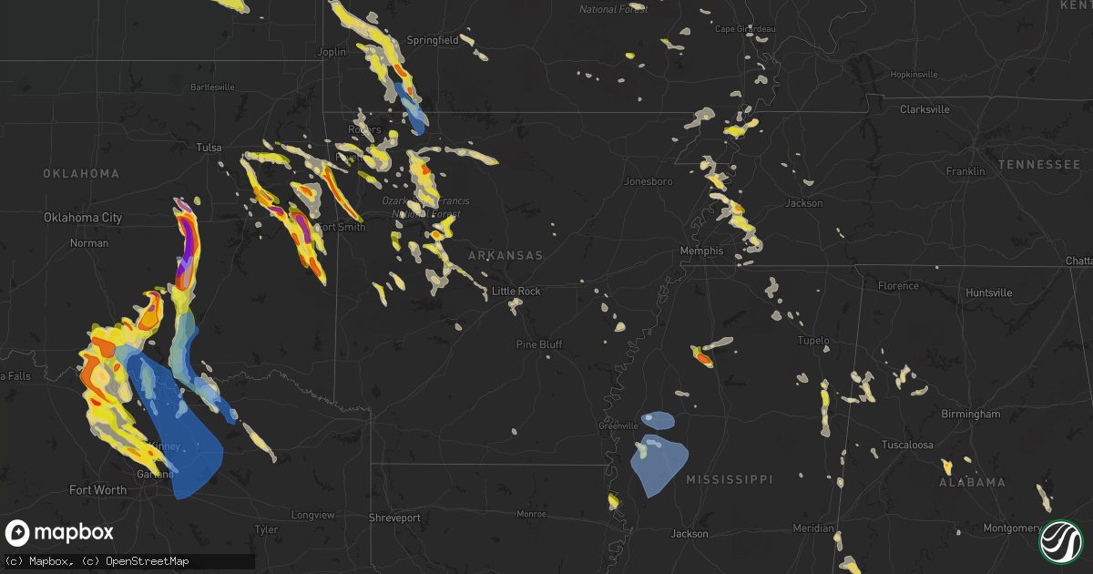
Hail Map in Arkansas on May 15, 2022
Get this storm
May 15 map
$229
one time, instant access
Download today. No call, no setup
Keep the $229
Bought the map and want the full workflow? Apply the entire $229 to a subscription within 7 days. None of it is wasted.
Every map, not just this one
This buys you this map. Subscription and you get every map we run, in the markets you choose from a few cities to whole states to nationwide. Plus real-time alerts the moment a storm fires.
Contact data
Name, contact info, occupancy, even credit band for addresses in the footprint. You go from where it hit to who to call.
Become the source they trust
Unlimited branding weather history reports on demand. You already have the documented answer ready for the property owner, and you are the one who showed up with it.
Property data and RoofTrace estimates
Pull up any address you have got, its value and the exact code rules for that jurisdiction, straight from One Click Code. Then RoofTrace estimates the squares, pitch, and roof value, priced the way you price.
Storm reports in Arkansas
Arkansas
| Date | Description |
|---|---|
| 05/15/20226:50 PM CDT | A tree was blown over a house on south cokley street. |
| 05/15/20226:50 PM CDT | Trees were down in lake village and around the county. |
| 05/15/20226:42 PM CDT | Recorded at private airport weather station. |
| 05/15/20226:40 PM CDT | At the pecan grove rv park on the south side of lake village... Several pecan trees were blown down or lost limbs. One tree fell onto an rv at the park... But no one wa |
| 05/15/20226:25 PM CDT | Big... Old hardwood trees were blown down around dermott. Blowing dust was also down to less than a quarter mile in the area before the rain started. Report relayed via |
| 05/15/20226:25 PM CDT | Trees and powerlines were blown down along highway 35. |
| 05/15/20226:23 PM CDT | A few tree limbs were blown down... And blowing dust was reported in the halley junction area. Report with video relayed via facebook. |
| 05/15/20226:15 PM CDT | Trees down south of the ua monticello campus |
| 05/15/20226:02 PM CDT | Trees down across the county |
| 05/15/20225:50 PM CDT | Trees blocking phillips st. |
| 05/15/20225:45 PM CDT | Trees down blocking alice st. |
| 05/15/20225:40 PM CDT | Trees down at kingsland |
| 05/15/20225:15 PM CDT | Asp reported a tree knocked over across hwy 54... Approx 4 miles west of hwy 79... Completely blocking the road...relayed by local em. Time is based on radar. |
| 05/15/20225:08 PM CDT | Social media picture of a large tree |
| 05/15/20225:02 PM CDT | Social media picture of large pine tree that was knocked over onto a power line on grant co rd 606. Grant co sheriff's deputy was dispatched to the scene. Time is based |
| 05/15/20225:02 PM CDT | A tree was reported down across manford rd. At caddo gap. |
| 05/15/20224:56 PM CDT | Local officials reported several trees and powerlines down near county club rd and floyd brown rd in brinkley. Time is based on radar data. |
| 05/15/20224:56 PM CDT | Local officials reported numerous trees and powerlines down across grant co. A tree was knocked over... Blocking hwy 46n in sheridan... W/ ar dot and sheridan fd dispat |
| 05/15/20224:44 PM CDT | Local em relayed that a business in poyen had sustained roof damage. |
| 05/15/20224:38 PM CDT | Trees down near east end |
| 05/15/20224:32 PM CDT | Social media picture of a tree that was blown onto an airstream trailer... Significantly damaging the trailer structure. No injuries were reported. Time is based on rad |
| 05/15/20224:32 PM CDT | Trees were reported down all around prairie county. A powerline was down on hwy. 302 in hazen. |
| 05/15/20224:32 PM CDT | Trees were reported down in lonoke. |
| 05/15/20224:26 PM CDT | Reports of multiple trees down on power lines in des arc... Relayed via nws chat. |
| 05/15/20224:26 PM CDT | Social media picture from the ashley downs subdivision... Showing a pontoon boat that had been blown away from it's original resting location into a drainage area behin |
| 05/15/20224:26 PM CDT | Downed trees at benton |
| 05/15/20224:26 PM CDT | Power lines were reported down all around garland county. A roof was blown off a storage building in the 6000 block of albert pike rd in hot springs. |
| 05/15/20224:14 PM CDT | Trees down near owensville |
| 05/15/20224:14 PM CDT | Social media picture of a large tree |
| 05/15/20224:11 PM CDT | A 50 knot peak wind gust was recorded at the little rock afb weather station. |
| 05/15/20224:10 PM CDT | Photo of ping pong ball-sized hail just south of the clear lake area. |
| 05/15/20224:10 PM CDT | A tree fell on a power line on north hills blvd. Just north of crestwood. |
| 05/15/20224:08 PM CDT | Social media picture of a large tree |
| 05/15/20224:08 PM CDT | A large tree was knocked down... Partially blocking jacksonville-cato rd between gibson and gravel ridge. |
| 05/15/20224:08 PM CDT | Trees down at newport |
| 05/15/20224:01 PM CDT | Report from mping: quarter |
| 05/15/20224:00 PM CDT | Report via twitter by media. |
| 05/15/20223:52 PM CDT | Report of large branches and a tree down on susan drive. |
| 05/15/20223:50 PM CDT | A tree was down on hwy. 36 at debbie lane. Just south of holland. |
| 05/15/20223:50 PM CDT | Pictures emailed showing multiple trees down around cloverdale blvd. One tree that fell caused minor damage to a house. |
| 05/15/20223:44 PM CDT | Social media picture of a large tree limb |
| 05/15/20223:35 PM CDT | Report of trees and power lines down near langley trailer park. |
| 05/15/20223:26 PM CDT | Perry co dispatch relayed via ham radio operator... Hwy 7 just south of fourche la fave river completely blocked with trees. Aplin fire was dispatched to clear the road |
| 05/15/20223:10 PM CDT | Observer has a few trees down around him. |
| 05/15/20223:09 PM CDT | A local report indicates 1.00 inch wind near 2 N NIMROD |
| 05/15/20223:08 PM CDT | Trees and powerlines down |
| 05/15/20222:55 PM CDT | *** 2 inj *** a tree fell on a vehicle near east 4th street in russellville. Two people were extricated from the vehicle and taken to the local hospital. |
| 05/15/20222:55 PM CDT | A tree fell on a house near north detroit avenue in russellville. No injuries were reported. |
| 05/15/20222:45 PM CDT | Nickel to quarter size hail was reported in paris. |
| 05/15/20222:40 PM CDT | Large tree limbs were blown down. |
| 05/15/20222:40 PM CDT | Numerous trees down along gunner pool road. Emergency manager reported campers were trapped within the campground due to trees blocking the road. No known injuries or s |
| 05/15/20222:20 PM CDT | Social media picture received of a tree blown over onto a truck in big flat. |
| 05/15/20222:15 PM CDT | A local report indicates 1.00 inch wind near CHICKALAH |
| 05/15/20222:13 PM CDT | Trees and powerlines down in mountain home |
| 05/15/20222:12 PM CDT | Reports of trees and powerlines down across johnson co... Location is based on radar data... And power outage maps. |
| 05/15/20222:12 PM CDT | Social media picture of a large tree limb |
| 05/15/20222:07 PM CDT | Trees blown down across the county. |
| 05/15/20221:52 PM CDT | Quarter size hail report was received via mping. |
| 05/15/20221:49 PM CDT | Social media picture of several golf ball sized hail stones on marina rd near lake dardanelle sp. |
| 05/15/20221:49 PM CDT | Trees blown down county wide. |
| 05/15/20221:40 PM CDT | A local report indicates 1.25 inch wind near LONDON |
| 05/15/20221:37 PM CDT | Trees and powerlines down near western grove |
| 05/15/20221:35 PM CDT | A local report indicates 1.00 inch wind near LONDON |
| 05/15/20221:05 PM CDT | Golf ball size hail was reported near boxley. |
| 05/15/20221:01 PM CDT | Uprooted tree. Reported via twitter by media. |
| 05/15/20221:00 PM CDT | A local report indicates 1.00 inch wind near 2 NE RUSSELLVILLE |
| 05/15/202212:57 PM CDT | Social media report of 1 inch hail in holiday island. |
| 05/15/202212:55 PM CDT | Report of tree limbs... Up to one inch in diameter broken by thunderstorm winds. |
| 05/15/202212:51 PM CDT | A local report indicates 1.00 inch wind near 3 E SONORA |
| 05/15/202212:45 PM CDT | Half dollar size hail report was received via mping. |
| 05/15/202212:45 PM CDT | Tin tore off barn roof and trees limbs down. |
| 05/15/202212:30 PM CDT | Tree snapped. Report via media on twitter. Time estimated by radar. |
| 05/15/20227:54 AM CDT | At 1254 PM CDT, a severe thunderstorm was located near Taral, or near Russellville, moving southeast at 10 mph. HAZARD...Ping pong ball size hail and 60 mph wind gusts. SOURCE...Radar indicated. IMPACT...People and animals outdoors will be injured. Expect hail damage to roofs, siding, windows, and vehicles. Expect wind damage to roofs, siding, and trees. Locations impacted include... Russellville... Atkins... Pottsville... Taral... Gum Log... This includes Interstate 40 between mile markers 81 and 95. |
| 05/15/20227:52 AM CDT | At 1251 PM CDT, a severe thunderstorm was located over Lake Dardanelle, or near Russellville, moving east at 10 mph. HAZARD...60 mph wind gusts and half dollar size hail. SOURCE...Radar indicated. IMPACT...Hail damage to vehicles is expected. Expect wind damage to roofs, siding, and trees. Locations impacted include... Russellville... Dardanelle... London... Lake Dardanelle... Lake Dardanelle State Park... Mt Nebo State Park...This includes Interstate 40 between mile markers 77 and 83. |
| 05/15/20227:47 AM CDT | At 1247 PM CDT, a severe thunderstorm was located 6 miles northwest of Wesley, moving southeast at 20 mph. HAZARD...60 mph wind gusts and quarter size hail. SOURCE...Radar indicated. IMPACT...Hail damage to vehicles is expected. Expect wind damage to roofs, siding, and trees. Locations in or near the path include... Fayetteville... Huntsville... Hindsville... Withrow Springs State Park... Wesley... Forum... Goshen... Alabam... Mayfield... Sonora... Tuttle... |
| 05/15/20227:39 AM CDT | At 1239 PM CDT, a severe thunderstorm was located near Upper Buffalo Wilderness Area, or 15 miles west of Jasper, moving east at 25 mph. HAZARD...60 mph wind gusts and quarter size hail. SOURCE...Radar indicated. IMPACT...Hail damage to vehicles is expected. Expect wind damage to roofs, siding, and trees. Locations impacted include... Jasper... Lost Valley State Park... Erbie... Upper Buffalo Wilderness Area... Pruitt... Wayton... Boxley... Mossville... Marble Falls... Low Gap... Crossroad... Parthenon... Gum Springs in Newton County... Ponca... Mt Sherman... |
| 05/15/20227:27 AM CDT | At 1227 PM CDT, severe thunderstorms were located along a line extending from Merriam Woods to near Roberson Hollow to Clifty, moving southeast at 25 mph. HAZARD...60 mph wind gusts and quarter size hail. SOURCE...Radar indicated. IMPACT...Hail damage to vehicles is expected. Expect wind damage to roofs, siding, and trees. Locations impacted include... Harrison... Diamond City... Bergman... Lead Hill... Omaha... Olvey... Myrtle... Roberson Hollow... Self... Erbie... Red Bank... Winington... Clark Hill... Capps... Willis... Upper Buffalo Wilderness Area... Bellefonte... Alpena... Crumpler Subdivision... Zinc... |
| 05/15/20227:22 AM CDT | At 1222 PM CDT, a severe thunderstorm was located near Marble, or 10 miles east of Huntsville, moving east at 10 mph. HAZARD...60 mph wind gusts and half dollar size hail. SOURCE...Radar indicated. IMPACT...Hail damage to vehicles is expected. Expect wind damage to roofs, siding, and trees. Locations impacted include... Upper Buffalo Wilderness Area... Compton... Ponca... |
| 05/15/20227:20 AM CDT | At 1220 PM CDT, a severe thunderstorm was located near Marble, moving north at 5 mph. HAZARD...60 mph wind gusts and half dollar size hail. SOURCE...Radar indicated. IMPACT...Hail damage to vehicles is expected. Expect wind damage to roofs, siding, and trees. Locations in or near the path include... Kingston... Osage... Marble... Delmar... Alabam... Dryfork... |
| 05/15/20227:10 AM CDT | At 1209 PM CDT, severe thunderstorms were located along a line extending from Rosetta to near Atkins, moving east at 20 mph. HAZARD...60 mph wind gusts and half dollar size hail. SOURCE...Radar indicated. IMPACT...Hail damage to vehicles is expected. Expect wind damage to roofs, siding, and trees. Locations impacted include... Russellville... Atkins... Pottsville... Dover... London... Hector... Happy Bend... Dillen... Broomfield... Hattieville... Solo... Devils Knob... Jerusalem... St. Vincent... Bertha... Taral... Rosetta... Lake Dardanelle... Appleton... Fort Douglas...This includes Interstate 40 between mile markers 78 and 88, andbetween mile markers 94 and 96. |
| 05/15/20227:02 AM CDT | At 1202 PM CDT, severe thunderstorms were located along a line extending from 7 miles northeast of Reeds Spring to Beaver, moving southeast at 25 mph. HAZARD...60 mph wind gusts and half dollar size hail. SOURCE...Radar indicated. IMPACT...Hail damage to vehicles is expected. Expect wind damage to roofs, siding, and trees. Locations impacted include... Omaha... Roberson Hollow... Alpena... New Hope in Boone County... Burlington... |
| 05/15/20226:31 AM CDT | At 1131 AM CDT, severe thunderstorms were located along a line extending from near Bertha to Holman, moving east at 25 mph. HAZARD...60 mph wind gusts and half dollar size hail. SOURCE...Radar indicated. IMPACT...Hail damage to vehicles is expected. Expect wind damage to roofs, siding, and trees. Locations impacted include... Broomfield... Solo... Bertha... Smyrna... Dillen... Sand Gap... Long Pool Campground... Simpson... Treat... Scottsville... Lutherville... Nogo... |
| 05/15/20226:23 AM CDT | At 1123 AM CDT, a severe thunderstorm was located near London, or 8 miles northwest of Russellville, moving east at 20 mph. HAZARD...Ping pong ball size hail and 60 mph wind gusts. SOURCE...Radar indicated. IMPACT...People and animals outdoors will be injured. Expect hail damage to roofs, siding, windows, and vehicles. Expect wind damage to roofs, siding, and trees. Locations impacted include... Russellville... Dover... London... Hector... Taral... Lake Dardanelle... Gum Log... Augsburg... Moreland... Scottsville... Pleasant Valley in Pope County... This includes Interstate 40 between mile markers 74 and 79. |
| 05/15/20226:18 AM CDT | At 1118 AM CDT, a severe thunderstorm was located near Devils Knob, or 15 miles north of Clarksville, moving east at 20 mph. HAZARD...Ping pong ball size hail and 60 mph wind gusts. SOURCE...Radar indicated. IMPACT...People and animals outdoors will be injured. Expect hail damage to roofs, siding, windows, and vehicles. Expect wind damage to roofs, siding, and trees. Locations impacted include... Rosetta... Ozone... Mineral Springs Recreation Area... |
| 05/15/20226:16 AM CDT | At 1116 AM CDT, a severe thunderstorm was located near Woodland, or near Clarksville, moving east at 20 mph. HAZARD...Ping pong ball size hail and 60 mph wind gusts. SOURCE...Radar indicated. IMPACT...People and animals outdoors will be injured. Expect hail damage to roofs, siding, windows, and vehicles. Expect wind damage to roofs, siding, and trees. Locations impacted include... Clarksville... Holman... Woodland... Lutherville... Hillcrest in Johnson County... |
| 05/15/20225:56 AM CDT | At 1055 AM CDT, a severe thunderstorm was located over Rosetta, or 19 miles south of Jasper, moving southeast at 15 mph. HAZARD...60 mph wind gusts and quarter size hail. SOURCE...Radar indicated. IMPACT...Hail damage to vehicles is expected. Expect wind damage to roofs, siding, and trees. Locations impacted include... Dillen... Walnut... Bertha... Rosetta... Devils Knob... Upper Buffalo Wilderness Area... Salus... Fort Douglas... Swain... Haw Creek Falls Campground... Dixon Ridge... Nail... Sand Gap... Mineral Springs Recreation Area... Red Star... Mossville... Fallsville... Treat... |
| 05/15/20224:09 AM CDT | At 908 PM CDT, severe thunderstorms were located along a line extending from 3 miles south of Vian to 4 miles northwest of Spiro, moving southeast at 25 mph. HAZARD...60 mph wind gusts and quarter size hail. SOURCE...Radar indicated. IMPACT...Hail damage to vehicles is expected. Expect wind damage to roofs, siding, and trees. Locations in or near the path include... Sallisaw... Poteau... Pocola... Muldrow... Roland... Spiro... Arkoma... Vian... Panama... Bokoshe... Gans... Cameron... Moffett... Shady Point... Rock Island... Cowlington... Scullyville... Braden... Mc Key... Cottonwood...This includes Interstate 40 in Oklahoma between mile markers 294 and328. |
| 05/15/20223:17 AM CDT | At 816 PM CDT, a severe thunderstorm was located near Lincoln, moving east at 35 mph. HAZARD...60 mph wind gusts and quarter size hail. SOURCE...Radar indicated. IMPACT...Hail damage to vehicles is expected. Expect wind damage to roofs, siding, and trees. Locations in or near the path include... Prairie Grove... West Fork... Lincoln... Greenland... Winslow... Brentwood... Cincinnati... Prairie Grove Battlefield State... Walnut Grove... Woolsey... Sulphur City... Hicks... Clyde... Rhea... Canehill... Hogeye... Summers... Viney Grove...This includes Interstate 49 between mile markers 45 and 57. |
| 05/15/20222:59 AM CDT | At 758 PM CDT, severe thunderstorms were located along a line extending from Maryetta to near Cookson, moving southeast at 35 mph. HAZARD...60 mph wind gusts and quarter size hail. SOURCE...Radar indicated. IMPACT...Hail damage to vehicles is expected. Expect wind damage to roofs, siding, and trees. Locations in or near the path include... Sallisaw... Stilwell... Marble City... Cookson... Brushy Lake State Park... Adair State Park... Brushy... Cherokee Landing State Park... Bunch... Short... Maryetta... This includes Interstate 40 in Oklahoma near mile marker 316. |
| 05/15/20222:40 AM CDT | At 740 PM CDT, a severe thunderstorm was located 4 miles southwest of Tontitown, moving east at 40 mph. HAZARD...Quarter size hail. SOURCE...Radar indicated. IMPACT...Damage to vehicles is expected. Locations in or near the path include... Fayetteville... Springdale... Huntsville... Farmington... Elkins... Tontitown... West Fork... Greenland... St. Paul... Hindsville... Wesley... Saint Paul... Aurora... Japton... Drake Field Airport... Johnson... Elm Springs... Goshen... Georgetown... Walnut Grove...This includes Interstate 49 between mile markers 55 and 73. |
| 05/15/20222:23 AM CDT | At 723 PM CDT, severe thunderstorms were located along a line extending from 4 miles southeast of Rose to 3 miles south of Peggs, moving east at 35 mph. HAZARD...60 mph wind gusts and quarter size hail. SOURCE...Radar indicated. IMPACT...Hail damage to vehicles is expected. Expect wind damage to roofs, siding, and trees. Locations in or near the path include... Tahlequah... Siloam Springs... Westville... West Siloam Springs... Kansas... Watts... Oaks... Eldon... Proctor... Christie... Peggs... Leach... Scraper... Twin Oaks... Baron... Ballard... Lost City... Natural Falls State Park... |
| 05/15/20222:12 AM CDT | At 712 PM CDT, a severe thunderstorm was located 6 miles northwest of Natural Dam, moving southeast at 30 mph. HAZARD...60 mph wind gusts and quarter size hail. SOURCE...Radar indicated. IMPACT...Hail damage to vehicles is expected. Expect wind damage to roofs, siding, and trees. Locations in or near the path include... Fort Smith... Van Buren... Cedarville... Natural Dam... Alma... Barling... Pocola... Roland... Lavaca... Arkoma... Dyer... Hackett... Bonanza... Moffett... Rudy... Lee Creek... Fort Smith Regional Airport... Short... Bloomer... Figure Five...This includes the following highways, Interstate 40 in Arkansas between mile markers 0 and 17. Interstate 40 in Oklahoma between mile markers 324 and 328. Interstate 540 between mile markers 1 and 14. Interstate 49 between mile markers 22 and 28. |
| 05/15/20222:06 AM CDT | At 706 PM CDT, severe thunderstorms were located along a line extending from near Tribbett to 7 miles east of Parkdale to near Crossett, moving southeast at 50 mph. HAZARD...60 mph wind gusts and quarter size hail. SOURCE...Radar indicated. IMPACT...Hail damage to vehicles is expected. Expect wind damage to roofs, siding, and trees. Severe thunderstorms will be near... Millikin and Gassoway around 720 PM CDT. Oak Grove and Galion around 725 PM CDT. Shelburn around 730 PM CDT. Lake Providence around 735 PM CDT. Transylvania and Alsatia around 745 PM CDT.Other locations impacted by these severe thunderstorms includeMayersville, Perryville, Collinston, Mer Rouge, Pioneer, Kilbourne,Forest, Cary, Bonita and Oak Ridge. |
| 05/15/20222:02 AM CDT | At 702 PM CDT, a severe thunderstorm was located 4 miles west of Farmington, moving southeast at 35 mph. HAZARD...60 mph wind gusts and half dollar size hail. SOURCE...Radar indicated. IMPACT...Hail damage to vehicles is expected. Expect wind damage to roofs, siding, and trees. Locations in or near the path include... Fayetteville... Farmington... Prairie Grove... West Fork... Greenland... Winslow... Blackburn... Brentwood... Drake Field Airport... Walnut Grove... Bidville... Woolsey... Savoy... Crosses... Rhea... Combs... Locke... Mount Gayler... Wheeler... Wyola...This includes Interstate 49 between mile markers 40 and 63. |
| 05/15/20221:57 AM CDT | At 657 PM CDT, a severe thunderstorm was located near Hilo, or 18 miles southeast of Hampton, moving southeast at 35 mph. HAZARD...60 mph wind gusts and quarter size hail. SOURCE...Radar indicated. IMPACT...Hail damage to vehicles is expected. Expect wind damage to roofs, siding, and trees. Locations impacted include... Ingalls... Hilo... Moro Bay State Park... Moro Bay... Vick... Marsden... Blanchton... |
| 05/15/20221:44 AM CDT | At 644 PM CDT, a severe thunderstorm was located near Heavener, moving southeast at 25 mph. HAZARD...60 mph wind gusts and half dollar size hail. SOURCE...Radar indicated. IMPACT...Hail damage to vehicles is expected. Expect wind damage to roofs, siding, and trees. Locations in or near the path include... Heavener... Heavener Runestone State Park... Hodgen... |
| 05/15/20221:22 AM CDT | At 621 PM CDT, severe thunderstorms were located along a line extending from near Jersey Point to near Ladelle to Hermitage, moving southeast at 45 mph. HAZARD...60 mph wind gusts. SOURCE...Radar indicated. IMPACT...Expect damage to roofs, siding, and trees. Severe thunderstorms will be near... Winterville around 640 PM CDT. Montrose and Snyder around 645 PM CDT. Greenville, West Crossett, North Crossett, Metcalfe and Portland around 650 PM CDT. Crossett and Leland around 655 PM CDT. Parkdale around 700 PM CDT. Wilmot and Tribbett around 705 PM CDT. Hollandale, Darlove and Estill around 715 PM CDT.Other locations impacted by these severe thunderstorms includeArcola. |
| 05/15/202212:50 AM CDT | At 549 PM CDT, a severe thunderstorm was located near Bokoshe, moving south at 30 mph. HAZARD...Two inch hail and 60 mph wind gusts. SOURCE...Radar indicated. IMPACT...People and animals outdoors will be injured. Expect hail damage to roofs, siding, windows, and vehicles. Expect wind damage to roofs, siding, and trees. Locations in or near the path include... Poteau... Heavener... Panama... Wister... Howe... Fanshawe... Heavener Runestone State Park... Lake Wister State Park... Shady Point... Hodgen... Summerfield... |
| 05/15/202212:50 AM CDT | At 549 PM CDT, severe thunderstorms were located along a line extending from near White River National Wildlife Refuge to near Mitchellville to near Mt Elba, moving southeast at 45 mph. HAZARD...60 mph wind gusts. SOURCE...Radar indicated. IMPACT...Expect damage to roofs, siding, and trees. Severe thunderstorms will be near... Gunnison and Deeson around 610 PM CDT. Shelby around 620 PM CDT. Mound Bayou around 625 PM CDT. Scott, Renova and Benoit around 635 PM CDT. Cleveland, Drew, Boyle and Lamont around 640 PM CDT. Ruleville around 645 PM CDT.Other locations impacted by these severe thunderstorms includeAlligator, Winstonville, Beulah, Pace, Duncan and Merigold. |
| 05/15/202212:47 AM CDT | At 546 PM CDT, severe thunderstorms were located along a line extending from near Toledo to Tipton to near Bearden, moving southeast at 40 mph. HAZARD...60 mph wind gusts and penny size hail. SOURCE...Radar indicated. IMPACT...Expect damage to roofs, siding, and trees. Locations impacted include... Warren... Fordyce... Rison... Hampton... Bearden... Hermitage... Wilmar... Kingsland... Thornton... Harrell... Ellisville... Harlow... Hampton Municipal Airport... Hebron... Weeks... Brandon... Mt Elba... Tipton... Marks Mill State Park... Toledo... |
| 05/15/202212:44 AM CDT | At 544 PM CDT, severe thunderstorms were located along a line extending from near St Francis National Park to 6 miles southwest of Elaine, moving southeast at 45 mph. HAZARD...60 mph wind gusts and quarter size hail. SOURCE...Radar indicated. IMPACT...Hail damage to vehicles is expected. Expect wind damage to roofs, siding, and trees. Locations impacted include... Clarksdale, Marianna, Marvell, Elaine, St Francis National Park, Helena-West Helena, White River National Wildlife Refuge, Tutwiler, Marks, Lambert, Jonestown, Friars Point, Tunica, Webb, Sledge, Sumner, Lexa, Rondo, Belen and Dubbs. |
| 05/15/202212:39 AM CDT | At 538 PM CDT, severe thunderstorms were located along a line extending from near St. Charles to Grady to Rison, moving southeast at 45 mph. HAZARD...60 mph wind gusts and penny size hail. SOURCE...Radar indicated. IMPACT...Expect damage to roofs, siding, and trees. Locations impacted include... Dumas... Star City... Rison... Rohwer... Gould... Gillett... Grady... Mitchellville... Tillar... Watson... Winchester... Whitefield... Plantersville... Little Bayou Meto Park... Douglas... Trusten Holder WMA... Herbine... Nebo... Feenyville... Yancopin... |
| 05/15/202212:07 AM CDT | At 506 PM CDT, severe thunderstorms were located along a line extending from 6 miles southeast of Sheridan to Leola to 8 miles east of Arkadelphia, moving southeast at 35 mph. HAZARD...60 mph wind gusts and nickel size hail. SOURCE...Radar indicated. IMPACT...Expect damage to roofs, siding, and trees. Locations impacted include... Arkadelphia... Fordyce... Rison... Leola... Kingsland... Sparkman... Carthage... Lamont... Toledo... Dogwood... Jenkins Ferry State Park... Tulip... Ouachita... Staves... Ivan... Dalark... Millerville... Ramsey... Cross Roads in Grant County... Princeton... |
| 05/15/202212:05 AM CDT | At 504 PM CDT, a severe thunderstorm was located near Holly Grove, or 8 miles east of Clarendon, moving southeast at 30 mph. HAZARD...60 mph wind gusts and penny size hail. SOURCE...Radar indicated. IMPACT...Expect damage to roofs, siding, and trees. Locations impacted include... Clarksdale, Marianna, Marvell, Elaine, Helena-West Helena, White River National Wildlife Refuge, St Francis National Park, Friars Point, Lexa, Moro, Rondo, Aubrey, Garret Grove, Watkins Corner, Kings, Sherard, New Salem, Crumrod, Lake View and Coahoma. |
| 05/14/202211:59 PM CDT | At 459 PM CDT, severe thunderstorms were located along a line extending from Garret Grove to Humphrey to near Sheridan, moving southeast at 40 mph. HAZARD...60 mph wind gusts and quarter size hail. SOURCE...Radar indicated. IMPACT...Hail damage to vehicles is expected. Expect wind damage to roofs, siding, and trees. Locations impacted include... Pine Bluff... Stuttgart... Clarendon... Rison... White Hall... Altheimer... Holly Grove... Humphrey... Grady... Almyra... St. Charles... Roe... Alfrey... Whitefield... Little Bayou Meto Park... Woodville... Cottondale... Lamont... Linwood... Pine Bluff Arsenal...This includes Interstate 530 between mile markers 27 and 46. |
| 05/14/202211:30 PM CDT | At 430 PM CDT, severe thunderstorms were located along a line extending from near Benton to near Hot Springs to near Meyers, moving southeast at 35 mph. HAZARD...60 mph wind gusts and quarter size hail. SOURCE...Radar indicated. IMPACT...Hail damage to vehicles is expected. Expect wind damage to roofs, siding, and trees. Locations impacted include... Hot Springs... Benton... Arkadelphia... Malvern... Sheridan... Haskell... Rockport... Caddo Valley... Traskwood... Leola... Tull... Carthage... Prattsville... Poyen... Perla... Lonsdale... Jenkins Ferry State Park... Lofton... Rockwell... DeGray Lake State Park...This includes Interstate 30 between mile markers 74 and 115. |
| 05/14/202211:18 PM CDT | At 417 PM CDT, severe thunderstorms were located along a line extending from near Tupelo to near Thurman to near Lonsdale, moving southeast at 40 mph. HAZARD...60 mph wind gusts and quarter size hail. SOURCE...Emergency management. IMPACT...Hail damage to vehicles is expected. Expect wind damage to roofs, siding, and trees. Locations impacted include... Little Rock... North Little Rock... Pine Bluff... Benton... Sherwood... Jacksonville... Cabot... Bryant... Downtown Little Rock... Stuttgart... Sheridan... Lonoke... Brinkley... Augusta... Des Arc... Clarendon... Hazen... De Valls Bluff... Southwest Little Rock... Little Rock AFB...This includes the following highways... Interstate 30 between mile markers 112 and 142. Interstate 40 between mile markers 151 and 218. Interstate 430 between mile markers 1 and 5. Interstate 530 between mile markers 1 and 35. Interstate 630 between mile markers 1 and 6. Interstate 440 between mile markers 1 and 14. US Highway 67 between mile markers 1 and 13. |
| 05/14/202211:06 PM CDT | At 406 PM CDT, a severe thunderstorm was located near Fort Pillow State Park, moving east at 20 mph. HAZARD...Half dollar size hail. SOURCE...Radar indicated. IMPACT...Damage to vehicles is expected. Locations impacted include... Covington, Ripley, Luxora, Fort Pillow State Park, Burdette, Fulton, Ashport, Ft Pillow, Henning, Garland, Edith, Dryhill, O'Donnell Bend, Tomato, Tuckertown, Rosa, Luckett, Flippin, Keyes Port and Rialto. |
| 05/14/202211:03 PM CDT | At 403 PM CDT, severe thunderstorms were located along a line extending from 8 miles southeast of Cardiff to near Oliver, moving southeast at 20 mph. HAZARD...60 mph wind gusts and quarter size hail. SOURCE...Radar indicated. IMPACT...Hail damage to vehicles is expected. Expect wind damage to roofs, siding, and trees. Locations impacted include... Waldron... Oden... Mimosa... Cedar Creek... Pencil Bluff... Pine Ridge... Needmore... Boles... Sims... Parks... Harvey... Cherry Hill in Polk County... Y City... |
| 05/14/202210:56 PM CDT | At 356 PM CDT, a severe thunderstorm was located near Salem in Saline County, or 8 miles north of Benton, moving southeast at 15 mph. HAZARD...60 mph wind gusts and quarter size hail. SOURCE...Radar indicated. IMPACT...Hail damage to vehicles is expected. Expect wind damage to roofs, siding, and trees. Locations impacted include... Little Rock... Benton... Bryant... Southwest Little Rock... Haskell... Shannon Hills... Otter Creek... Ironton... Mabelvale... Salem in Saline County... Geyer Springs... Chenal Valley... Alexander... Baseline... Bauxite... Avilla... Congo... Vimy Ridge... Grape... Bland...This includes the following highways... Interstate 30 between mile markers 112 and 134. Interstate 430 between mile markers 1 and 4. Interstate 530 near mile marker 5. |
| 05/14/202210:52 PM CDT | At 352 PM CDT, a severe thunderstorm was located 4 miles north of Rudy, moving southeast at 30 mph. HAZARD...Golf ball size hail and 60 mph wind gusts. SOURCE...Radar indicated. IMPACT...People and animals outdoors will be injured. Expect hail damage to roofs, siding, windows, and vehicles. Expect wind damage to roofs, siding, and trees. Locations in or near the path include... Van Buren... Charleston... Cedarville... Mountainburg... Alma... Lavaca... Mulberry... Dyer... Branch... Rudy... Bloomer... Figure Five... Kibler... Concord... Shibley... Meg... Peter Pender... Vesta... Cecil... Furry...This includes the following highways, Interstate 40 in Arkansas between mile markers 7 and 24. Interstate 49 between mile markers 22 and 31. |
| 05/14/202210:51 PM CDT | At 350 PM CDT, severe thunderstorms were located along a line extending from 7 miles south of Adona to near Lake Ouachita State Park to near Muddy Creek WMA, moving southeast at 40 mph. These storms have a history of wind damage and large hail! HAZARD...70 mph wind gusts and half dollar size hail. SOURCE...Law enforcement. IMPACT...Hail damage to vehicles is expected. Expect considerable tree damage. Wind damage is also likely to mobile homes, roofs, and outbuildings. Locations impacted include... Hot Springs... Benton... Hot Springs Village... Malvern... Mount Ida... Haskell... Mountain Pine... Rockport... Traskwood... Norman... Perla... Lonsdale... Meyers... Jessieville... Lake Ouachita State Park... Lofton... Rockwell... Mauldin... Salem in Saline County... Williams Junction...This includes Interstate 30 between mile markers 91 and 116. |
| 05/14/202210:45 PM CDT | At 345 PM CDT, severe thunderstorms were located along a line extending from near Mount Pleasant to near Moorefield to near Oil Trough to Searcy, moving southeast at 40 mph. HAZARD...60 mph wind gusts and quarter size hail. SOURCE...Radar indicated. IMPACT...Hail damage to vehicles is expected. Expect wind damage to roofs, siding, and trees. Locations impacted include... Newport... Cave City... Tuckerman... Diaz... Newark... Swifton... Mount Pleasant... Grubbs... Oil Trough... Jacksonport... Magness... Sidney... Tupelo... Alicia... Algoa... McFadden... Stella... Sulphur Rock... Campbell Station... Beedeville...This includes US Highway 67 between mile markers 69 and 101. |
| 05/14/202210:41 PM CDT | At 340 PM CDT, severe thunderstorms were located along a line extending from 7 miles east of Pleasant Plains to near Gravel Hill to Mayflower, moving southeast at 45 mph. HAZARD...60 mph wind gusts and quarter size hail. SOURCE...Trained weather spotters. IMPACT...Hail damage to vehicles is expected. Expect wind damage to roofs, siding, and trees. Locations impacted include... Little Rock... North Little Rock... Conway... Sherwood... Jacksonville... Cabot... Searcy... West Little Rock... Maumelle... Downtown Little Rock... Lonoke... Augusta... Des Arc... North Little Rock Airport... Little Rock AFB... Beebe... Ward... Vilonia... Bald Knob... Mayflower...This includes the following highways... Interstate 30 between mile markers 136 and 142. Interstate 40 between mile markers 128 and 176. Interstate 430 between mile markers 8 and 12. Interstate 530 between mile markers 1 and 3. Interstate 630 between mile markers 1 and 6. Interstate 440 between mile markers 1 and 14. US Highway 67 between mile markers 1 and 71. |
| 05/14/202210:29 PM CDT | At 328 PM CDT, severe thunderstorms were located along a line extending from Pineville to near Gid to 7 miles northeast of Heber Springs to near Springfield, moving east at 35 mph. HAZARD...60 mph wind gusts and quarter size hail. SOURCE...Trained weather spotters have reported numerous trees down from damaging winds. Wind damage is likely! IMPACT...Hail damage to vehicles is expected. Expect wind damage to roofs, siding, and trees. Locations impacted include... Batesville... Heber Springs... Melbourne... Greenbrier... Vilonia... Newark... Greers Ferry... Quitman... Guy... Pangburn... Rose Bud... Cushman... Mount Pleasant... Pleasant Plains... Enola... Oil Trough... Concord... Magness... Sidney... Mount Vernon... |
| 05/14/202210:25 PM CDT | At 325 PM CDT, severe thunderstorms were located along a line extending from 7 miles southwest of Adona to 10 miles south of Plainview in Yell County to near Gravelly, moving southeast at 30 mph. HAZARD...60 mph wind gusts and half dollar size hail. SOURCE...Radar indicated. IMPACT...Hail damage to vehicles is expected. Expect wind damage to roofs, siding, and trees. Locations impacted include... Hot Springs Village... Jessieville... Lake Ouachita State Park... Williams Junction... Avant... Aplin... Chula... Deberrie... Gibbs... Mt Tabor... Fannie... Mountain Valley... Lena Landing Rec Area... Long Mountain... Hamilton... Hollis... Sims... Reform... Story... Washita... |
| 05/14/202210:20 PM CDT | At 320 PM CDT, severe thunderstorms were located along a line extending from near Middleton to near Houston, moving southeast at 30 mph. HAZARD...60 mph wind gusts and quarter size hail. SOURCE...Radar indicated. IMPACT...Hail damage to vehicles is expected. Expect wind damage to roofs, siding, and trees. Locations impacted include... Conway... Morrilton... Greenbrier... Mayflower... Wooster... Oppelo... Guy... Damascus... Twin Groves... Menifee... Houston... Bethlehem... Sequoya Park... Hill Creek... Pickles Gap... Solgohachia... Cleveland... Catholic Point... Middleton... Lanty...This includes Interstate 40 between mile markers 105 and 137. |
| 05/14/202210:13 PM CDT | At 312 PM CDT, a severe thunderstorm was located near Williams Junction, or 15 miles south of Perryville, moving southeast at 20 mph. HAZARD...60 mph wind gusts and half dollar size hail. SOURCE...Radar indicated. IMPACT...Hail damage to vehicles is expected. Expect wind damage to roofs, siding, and trees. Locations impacted include... Little Rock... West Little Rock... Chenal Valley... Williams Junction... Wye Mountain... Pinnacle Mountain State Park... Avilla... Paron... Grape... Bland... Ferndale... Congo... |
| 05/14/202210:10 PM CDT | At 310 PM CDT, severe thunderstorms were located along a line extending from near Stonehouse Recreation Area to near Fourche Valley to near Plainview in Yell County, moving southeast at 30 mph. HAZARD...60 mph wind gusts and half dollar size hail. SOURCE...Radar indicated. IMPACT...Hail damage to vehicles is expected. Expect wind damage to roofs, siding, and trees. Locations impacted include... Danville... Ola... Stonehouse Recreation Area... Plainview in Yell County... Gravelly... Fourche Valley... Muddy Creek WMA... Corinth... Carter Cove Park... Wing... Chula... Macedonia in Yell County... Waltreak... Kingston... Bluffton... Rover... Fourche Junction... Hollis... Onyx... Fourche Mountain Recreation Are... |
| 05/14/20229:44 PM CDT | At 244 PM CDT, severe thunderstorms were located along a line extending from near Taral to near Danville to near Ratcliff, moving east at 30 mph. HAZARD...60 mph wind gusts and half dollar size hail. SOURCE...Radar indicated. IMPACT...Hail damage to vehicles is expected. Expect wind damage to roofs, siding, and trees. Locations impacted include... Paris... Danville... Dardanelle... Atkins... Pottsville... Ola... Magazine... Ratcliff... Blue Mountain... Stonehouse Recreation Area... Carden Bottoms... Happy Bend... Solgohachia... Hattieville... Petit Jean State Park... Mount Magazine... Plainview in Yell County... Petit Jean River WMA... Galla Creek WMA... St. Vincent...This includes Interstate 40 between mile markers 89 and 106. |
| 05/14/20229:40 PM CDT | At 240 PM CDT, a severe thunderstorm was located near Ola, or 12 miles east of Danville, moving southeast at 20 mph. HAZARD...60 mph wind gusts and quarter size hail. SOURCE...Radar indicated. IMPACT...Hail damage to vehicles is expected. Expect wind damage to roofs, siding, and trees. Locations impacted include... Ola... Adona... Petit Jean State Park... Petit Jean River WMA... Casa... Aplin... Birta... Ada... Lakeview in Yell County... Nimrod... Deberrie... Pontoon... Centerville... Fourche Junction... |
| 05/14/20229:32 PM CDT | At 231 AM CDT, a severe thunderstorm was located 3 miles southwest of Honey Creek State Park, moving east at 20 mph. HAZARD...60 mph wind gusts and quarter size hail. SOURCE...Radar indicated. IMPACT...Hail damage to vehicles is expected. Expect wind damage to roofs, siding, and trees. Locations in or near the path include... Jay... Grove... Honey Creek State Park... Zena... |
| 05/14/20229:28 PM CDT | At 228 PM CDT, a severe thunderstorm was located near Williams Junction, or 8 miles southwest of Perryville, moving southeast at 15 mph. HAZARD...60 mph wind gusts and half dollar size hail. SOURCE...Radar indicated. IMPACT...Hail damage to vehicles is expected. Expect wind damage to roofs, siding, and trees. Locations impacted include... Perryville... Little Italy... Wye Mountain... Williams Junction... Roland in Pulaski County... Antioch in Perry County... Wye... Oak Grove in Perry County... Long Mountain... Paron... Grape... Thornburg... Bland... Reform... Cherry Hill in Perry County... Ferndale... Pleasant Valley in Perry County... |
| 05/14/20229:26 PM CDT | At 226 PM CDT, a severe thunderstorm was located 8 miles west of Blanchard Springs Campground, or 15 miles northwest of Mountain View, moving east at 35 mph. HAZARD...60 mph wind gusts and quarter size hail. SOURCE...Radar indicated. IMPACT...Hail damage to vehicles is expected. Expect wind damage to roofs, siding, and trees. Locations impacted include... Mountain View... Melbourne... Calico Rock... Pineville... Brandenberg... Lone Star... Gorby... Herron... Herpel... Advance... Cartney... Lunenburg... Culp... Blanchard Springs Campground... Big Flat... Guion... Allison... Hanover... Mt Olive in Izard County... Gunner Pool Campground... |
| 05/14/20229:24 PM CDT | At 224 PM CDT, severe thunderstorms were located along a line extending from near Hector to near London to near Hartman, moving southeast at 30 mph. HAZARD...Ping pong ball size hail and 60 mph wind gusts. SOURCE...Radar indicated. IMPACT...People and animals outdoors will be injured. Expect hail damage to roofs, siding, windows, and vehicles. Expect wind damage to roofs, siding, and trees. Locations impacted include... Russellville... Clarksville... Paris... Dardanelle... Atkins... Pottsville... Lamar... Dover... London... Knoxville... Subiaco... Hartman... Hector... Scranton... Lake Dardanelle State Park... Hoyt... Jerusalem... Midway in Logan County... Blick... Mosley...This includes Interstate 40 between mile markers 58 and 59, andbetween mile markers 61 and 90. |
| 05/14/20229:15 PM CDT | At 215 PM CDT, a severe thunderstorm was located 6 miles southeast of Brentwood, moving southeast at 25 mph. HAZARD...60 mph wind gusts and quarter size hail. SOURCE...Radar indicated. IMPACT...Hail damage to vehicles is expected. Expect wind damage to roofs, siding, and trees. Locations in or near the path include... Ozark... Altus... Denning... Wiederkehr Village... Cass... Fern... Jethro... Bidville... Alix... Barnes... Redding... Watalula... Locke... Turners Bend... Mount Gayler... Lonelm... Taft... Cravens... Paradise... This includes Interstate 40 in Arkansas between mile markers 28 and42. |
| 05/14/20229:08 PM CDT | At 208 PM CDT, a severe thunderstorm was located near Midway in Logan County, or 13 miles east of Paris, moving east at 25 mph. HAZARD...60 mph wind gusts and half dollar size hail. SOURCE...Radar indicated. IMPACT...Hail damage to vehicles is expected. Expect wind damage to roofs, siding, and trees. Locations impacted include... Russellville... Dardanelle... Pottsville... Lake Dardanelle State Park... Galla Creek WMA... Mt Nebo State Park... Mosley... Lake Dardanelle... Holla Bend... Mt George... Delaware... Chickalah... Centerville... |
| 05/14/20229:04 PM CDT | At 204 PM CDT, a severe thunderstorm was located near Adona, or 7 miles southwest of Perryville, moving east at 20 mph. HAZARD...60 mph wind gusts and half dollar size hail. SOURCE...Radar indicated. IMPACT...Hail damage to vehicles is expected. Expect wind damage to roofs, siding, and trees. Locations impacted include... Perryville... Oppelo... Perry... Adona... Houston... Carden Bottoms... Petit Jean State Park... Wye Mountain... Williams Junction... Bigelow... Casa... Aplin... Fourche... Birta... Antioch in Perry County... Ada... Nimrod... Oak Grove in Perry County... Thornburg... Pleasant Valley in Perry County... |
| 05/14/20228:57 PM CDT | At 157 PM CDT, severe thunderstorms were located along a line extending from 6 miles south of Piercetown to near Rosetta to 7 miles east of Cass, moving southeast at 30 mph. HAZARD...Two inch hail and 60 mph wind gusts. SOURCE...Radar indicated. IMPACT...People and animals outdoors will be injured. Expect hail damage to roofs, siding, windows, and vehicles. Expect wind damage to roofs, siding, and trees. Locations impacted include... Clarksville... Lamar... Dover... London... Knoxville... Subiaco... Hartman... Hector... Scranton... Witts Spring... Woodland... Hinkle... Broomfield... Moore... Solo... Smyrna... Hoyt... Midway in Logan County... Spadra... Tokalon...This includes Interstate 40 between mile markers 44 and 75. |
| 05/14/20228:51 PM CDT | At 150 PM CDT, severe thunderstorms were located along a line extending from near Rush to Moore, moving southeast at 30 mph. HAZARD...60 mph wind gusts and quarter size hail. SOURCE...Radar indicated. IMPACT...Hail damage to vehicles is expected. Expect wind damage to roofs, siding, and trees. Locations impacted include... Marshall... Yellville... Thola... Marsena... Kay... Witts Spring... Rocky Hill... Duff... Dabney... Maumee... Rush... Bohannon... Woolum... Imo... Elberta... Watts... Summit... Leslie... Big Flat... Gilbert... |
| 05/14/20228:41 PM CDT | At 140 PM CDT, severe thunderstorms were located along a line extending from 2 miles west of Tontitown to 3 miles east of Fayetteville, moving southeast at 30 mph. HAZARD...60 mph wind gusts and quarter size hail. SOURCE...Radar indicated. IMPACT...Hail damage to vehicles is expected. Expect wind damage to roofs, siding, and trees. Locations in or near the path include... Fayetteville... Springdale... Farmington... Elkins... Tontitown... West Fork... Greenland... Winslow... St. Paul... Wesley... Saint Paul... Pettigrew... Brentwood... Japton... Drake Field Airport... Johnson... Goshen... Walnut Grove... Woolsey... Crosses...This includes Interstate 49 between mile markers 46 and 72. |
| 05/14/20228:33 PM CDT | At 133 PM CDT, severe thunderstorms were located along a line extending from 7 miles northwest of Moore to near Devils Knob to near Elkins, moving southeast at 30 mph. HAZARD...Ping pong ball size hail and 60 mph wind gusts. SOURCE...Radar indicated. IMPACT...People and animals outdoors will be injured. Expect hail damage to roofs, siding, windows, and vehicles. Expect wind damage to roofs, siding, and trees. Locations impacted include... Witts Spring... Dillen... Moore... Solo... Smyrna... Devils Knob... Walnut... Bertha... Rosetta... Ben Hur... Oak Grove in Johnson County... Catalpa... Fort Douglas... Yale... Long Pool Campground... Fallsville... Haw Creek Falls Campground... Oark... Wolf Pen Campground... Tilly... |
| 05/14/20228:27 PM CDT | At 127 PM CDT, a severe thunderstorm was located over Lake Dardanelle, or 7 miles west of Russellville, moving east at 15 mph. HAZARD...60 mph wind gusts and half dollar size hail. SOURCE...Radar indicated. IMPACT...Hail damage to vehicles is expected. Expect wind damage to roofs, siding, and trees. Locations impacted include... Russellville... Dardanelle... Atkins... Pottsville... London... Lake Dardanelle State Park... Carden Bottoms... Lake Dardanelle... Galla Creek WMA... Mt Nebo State Park... Mosley... Taral... Birta... Lakeview in Yell County... Holla Bend... Delaware... Centerville... Gum Log... Economy... Oak Grove in Pope County...This includes Interstate 40 between mile markers 72 and 97. |
| 05/14/20228:18 PM CDT | At 118 PM CDT, severe thunderstorms were located along a line extending from Harrison to near Upper Buffalo Wilderness Area, moving southeast at 35 mph. HAZARD...Ping pong ball size hail and 60 mph wind gusts. SOURCE...Radar indicated. IMPACT...People and animals outdoors will be injured. Expect hail damage to roofs, siding, windows, and vehicles. Expect wind damage to roofs, siding, and trees. Locations impacted include... Harrison... Bergman... Lost Valley State Park... Capps... Erbie... Upper Buffalo Wilderness Area... Red Bank... Bellefonte... Batavia... Boxley... Mossville... Marble Falls... Compton... Low Gap... Gaither... Ponca... Mt Sherman... |
| 05/14/20228:08 PM CDT | At 108 PM CDT, severe thunderstorms were located along a line extending from 3 miles north of Wesley to near Forum, moving southeast at 15 mph. HAZARD...60 mph wind gusts and half dollar size hail. SOURCE...Radar indicated. IMPACT...Hail damage to vehicles is expected. Expect wind damage to roofs, siding, and trees. Locations in or near the path include... Huntsville... Elkins... St. Paul... Wesley... Saint Paul... Kingston... Forum... Aurora... Boston... Withrow Springs State Park... Pettigrew... Japton... Witter... Marble... Georgetown... Red Star... Alabam... Crosses... Combs... Dutton... |
| 05/14/20227:59 PM CDT | Local news media report via twitter. |
| 05/14/20227:50 PM CDT | A local report indicates 1.00 inch wind near 3 NE WHEELER |
| 05/14/20227:17 PM CDT | Report via twitter. Nickel to quarter size hail. |
All States Impacted by Hail Map on May 15, 2022
Cities Impacted by Hail Map on May 15, 2022
- Marshall, IL
- Dennison, IL
- Attica, IN
- Portageville, MO
- Hayti, MO
- Ridgely, TN
- Tiptonville, TN
- Yellville, AR
- Everton, AR
- Bonne Terre, MO
- French Village, MO
- South Greenfield, MO
- Miller, MO
- Sainte Genevieve, MO
- Pleasant Hall, PA
- Orrstown, PA
- Upperstrasburg, PA
- Willow Hill, PA
- Fort Loudon, PA
- Shippensburg, PA
- Fannettsburg, PA
- Chambersburg, PA
- Ellsinore, MO
- Hardinsburg, KY
- Blairs Mills, PA
- Humboldt, TN
- Trenton, TN
- Harned, KY
- Webster, KY
- Kinmundy, IL
- Marshall, AR
- Saint Joe, AR
- Harriet, AR
- Valley Springs, AR
- Western Grove, AR
- Harrison, AR
- Blackwell, MO
- Cadet, MO
- De Soto, MO
- Marshfield, MO
- Rector, AR
- Marmaduke, AR
- Green Forest, AR
- Berryville, AR
- Eureka Springs, AR
- Martinsville, IL
- Hensley, AR
- Mabelvale, AR
- Little Rock, AR
- Malden, MO
- Piggott, AR
- Gideon, MO
- Holcomb, MO
- Clarkton, MO
- Campbell, MO
- Gibson, MO
- Greenway, AR
- Parma, MO
- Caryville, FL
- Cottonwood, AL
- Preston, MS
- Marble Falls, AR
- Oark, AR
- Hagarville, AR
- Clarksville, AR
- Deer, AR
- Jasper, AR
- Ponca, AR
- Huntsville, AR
- Kingston, AR
- Witter, AR
- Pettigrew, AR
- Ozone, AR
- Parthenon, AR
- Alpena, AR
- Compton, AR
- Bigelow, AR
- Salem, IL
- Whitewright, TX
- Savoy, TX
- Bonham, TX
- Ector, TX
- Otterbein, IN
- Atchison, KS
- Pangburn, AR
- Wappapello, MO
- Bristow, OK
- Adams, OR
- Junction City, KS
- Council Grove, KS
- Alma, KS
- Dwight, KS
- Alta Vista, KS
- White City, KS
- Allen, KS
- Fort Riley, KS
- Saint Paul, AR
- West Union, IL
- Oskaloosa, KS
- Dardanelle, AR
- Paris, AR
- Danville, AR
- Havana, AR
- Belleville, AR
- Troy, AL
- Foley, AL
- Sanger, TX
- Sulphur, OK
- Gainesville, TX
- Stonewall, OK
- Lake Dallas, TX
- Wylie, TX
- Collinsville, TX
- Ringling, OK
- Mannsville, OK
- Ada, OK
- Ardmore, OK
- Garland, TX
- Decatur, TX
- Forestburg, TX
- Tioga, TX
- Plano, TX
- Thackerville, OK
- Aubrey, TX
- Saint Jo, TX
- Tishomingo, OK
- Lindsay, TX
- Springer, OK
- Mckinney, TX
- Burneyville, OK
- Little Elm, TX
- Carrollton, TX
- Lavon, TX
- Leon, OK
- Rockwall, TX
- Milburn, OK
- Denton, TX
- Royse City, TX
- Frisco, TX
- The Colony, TX
- Rosston, TX
- Allen, TX
- Overbrook, OK
- Wilson, OK
- Era, TX
- Princeton, TX
- Dallas, TX
- Madill, OK
- Fitzhugh, OK
- Richardson, TX
- Celina, TX
- Marietta, OK
- Muenster, TX
- Whitesboro, TX
- Prosper, TX
- Krum, TX
- Healdton, OK
- Roff, OK
- Mill Creek, OK
- Valley View, TX
- Davis, OK
- Pilot Point, TX
- Lone Grove, OK
- Fayetteville, AR
- Elkins, AR
- Winslow, AR
- Taylorville, IL
- Hartman, AR
- Hickman, KY
- Pineville, MO
- Rogers, AR
- Lowell, AR
- Springdale, AR
- Bentonville, AR
- Bella Vista, AR
- Pea Ridge, AR
- Seligman, MO
- McClure, IL
- Bixby, OK
- Haskell, OK
- Tampa, KS
- Durham, KS
- Marion, KS
- Rossville, TN
- Moscow, TN
- Lamar, AR
- Eagle Rock, MO
- Tahlequah, OK
- Parks, AR
- Etta, MS
- New Albany, MS
- Myrtle, MS
- Bradford, TN
- Perryville, MO
- Saint Mary, MO
- Bainbridge, GA
- Holly Grove, AR
- Howe, TX
- Jackson, AL
- Hornbeak, TN
- Bloomsdale, MO
- Milledgeville, TN
- Morris Chapel, TN
- Grapeland, TX
- Elkhart, TX
- Denham Springs, LA
- Greenwell Springs, LA
- Clinton, LA
- Thorsby, AL
- Booneville, AR
- Sulligent, AL
- Beaverton, AL
- Millport, AL
- Kennedy, AL
- Vernon, AL
- Jacob, IL
- Williamsburg, KS
- Princeton, KS
- Quincy, MO
- Farmington, MO
- Webber, KS
- Dana, IN
- Chrisman, IL
- Cayuga, IN
- Kingman, IN
- Montezuma, IN
- Hillsdale, IN
- Broken Arrow, OK
- Altus, AR
- Coal Hill, AR
- Okmulgee, OK
- Silva, MO
- Patterson, MO
- Greenville, MO
- Lowndes, MO
- Flat Rock, IL
- Strong City, KS
- Hindsville, AR
- Wesley, AR
- Siloam Springs, AR
- Birch Tree, MO
- Hamilton, MS
- Pryor, OK
- Locust Grove, OK
- Chouteau, OK
- Gentry, AR
- Colcord, OK
- Parsons, KS
- Peggs, OK
- Proctor, OK
- Rose, OK
- Summers, AR
- Rudy, AR
- Chester, AR
- Canehill, AR
- Westville, OK
- Van Buren, AR
- Evansville, AR
- Cedarville, AR
- Prairie Grove, AR
- Alma, AR
- Uniontown, AR
- Stilwell, OK
- Lincoln, AR
- Natural Dam, AR
- Mason, IL
- Louisville, IL
- Roland, AR
- Guide Rock, NE
- Superior, NE
- Doniphan, MO
- Breese, IL
- Germantown, IL
- Doe Run, MO
- Mascoutah, IL
- Reading, KS
- Oaktown, IN
- Palestine, IL
- Lockwood, MO
- Golden City, MO
- Manila, AR
- Hulbert, OK
- Wagoner, OK
- Inola, OK
- Montevallo, AL
- Calera, AL
- Robertsdale, AL
- Matthews, MO
- New Madrid, MO
- Harwood, MO
- Walker, MO
- Charleston, MO
- Checotah, OK
- Lavinia, TN
- Milan, TN
- Medina, TN
- Paris, IL
- Robinson, IL
- Veedersburg, IN
- Shell Knob, MO
- Pierce City, MO
- Lampe, MO
- Sarcoxie, MO
- Galena, MO
- Kimberling City, MO
- Ash Grove, MO
- Aurora, MO
- Cassville, MO
- Stotts City, MO
- Monett, MO
- Lamar, MO
- Wentworth, MO
- Cape Fair, MO
- Jasper, MO
- Liberal, MO
- Purdy, MO
- Crane, MO
- La Russell, MO
- Golden, MO
- Blue Eye, MO
- Oak Grove, AR
- Mount Vernon, MO
- Marionville, MO
- Reeds, MO
- Carthage, MO
- Verona, MO
- Freistatt, MO
- Reeds Spring, MO
- Anniston, MO
- East Prairie, MO
- Brundidge, AL
- Louisville, AL
- Banks, AL
- Lyndon, KS
- Quenemo, KS
- Burlingame, KS
- Eskridge, KS
- Lebo, KS
- Harveyville, KS
- Osage City, KS
- Vassar, KS
- Alton, MO
- Cammal, PA
- Valles Mines, MO
- Boynton, OK
- Biscoe, AR
- Williamsport, IN
- West Lebanon, IN
- Centerville, KS
- Greeley, KS
- Garnett, KS
- Parker, KS
- Perrysville, IN
- Covington, IN
- Wingo, KY
- Clinton, KY
- Annapolis, MO
- Lesterville, MO
- Ironton, MO
- Seymour, MO
- Fordland, MO
- Cave Springs, AR
- Chunchula, AL
- Citronelle, AL
- Blytheville, AR
- Ripley, TN
- Hornersville, MO
- Steele, MO
- Luxora, AR
- McIntosh, AL
- Shady Point, OK
- Gans, OK
- Braggs, OK
- Spiro, OK
- Warner, OK
- Sallisaw, OK
- Stigler, OK
- Mccurtain, OK
- Heavener, OK
- Muskogee, OK
- Coweta, OK
- Webbers Falls, OK
- Porum, OK
- Wister, OK
- Oktaha, OK
- Bokoshe, OK
- Howe, OK
- Porter, OK
- Gore, OK
- Poteau, OK
- Muldrow, OK
- Vian, OK
- Cameron, OK
- Keota, OK
- Ashford, AL
- West Point, MS
- Aberdeen, MS
- Columbus, MS
- Crawford, MS
- Fort Walton Beach, FL
- Navarre, FL
- Gulf Breeze, FL
- Defuniak Springs, FL
- Milton, FL
- Eglin Afb, FL
- Niceville, FL
- Freeport, FL
- Valparaiso, FL
- Malvern, AR
- Combs, AR
- Parrish, AL
- Townley, AL
- Carbon Hill, AL
- Jasper, AL
- Oakman, AL
- Berry, AL
- West Blocton, AL
- Brierfield, AL
- Centreville, AL
- Coffeeville, AL
- Gilbertown, AL
- Thomasville, AL
- Toxey, AL
- Needham, AL
- Butler, AL
- Tibbie, AL
- Aliceville, AL
- Macon, MS
- Greenville, TX
- Panama City, FL
- Scooba, MS
- Emelle, AL
- Pattison, MS
- Union Church, MS
- Houston, MS
- Prairie, MS
- Okolona, MS
- McLouth, KS
- Sherman, TX
- Mayersville, MS
- Sondheimer, LA
- Transylvania, LA
- Greenwood, MS
- Oxford, MS
- Pope, MS
- Courtland, MS
- Batesville, MS
- Enid, MS
- Water Valley, MS
- Wells, TX
- Alto, TX
- Irvington, AL
- Buras, LA
- Yates Center, KS
- Hendrix, OK
- El Dorado, KS
- Fort White, FL
- Lake City, FL
- Archer, FL
- Newberry, FL
- Polk City, FL
- Auburndale, FL
- Lake Alfred, FL
- Henning, TN
- Covington, TN
- Coden, AL
- Centrahoma, OK
- Allen, OK
- Tupelo, OK
- Coalgate, OK
- Belle Chasse, LA
- Harvey, LA
- Braithwaite, LA
- Marrero, LA
- Albion, IL
- Hollandale, MS
- Fort Lauderdale, FL
- Pottsboro, TX
- Kingston, OK
- Denison, TX
- Park Hill, OK
- Welling, OK
- Bunch, OK
- Cookson, OK
- Newellton, LA
- Severy, KS
- Eureka, KS
- Somerville, TN
- Mason, TN
- Brighton, TN
- Eldridge, AL
- Nauvoo, AL
- Homestead, FL
- Miami, FL
- Hamilton, KS
- Kenansville, FL
- Saint Cloud, FL
- Diberville, MS
- Biloxi, MS
- Saucier, MS
- Mobile, AL
- Semmes, AL
- Wilmer, AL
- London, AR
- Russellville, AR
- Peabody, KS
- Hillsboro, KS
- Telephone, TX
- Honey Grove, TX
- Summerdale, AL
- Virgil, KS
- Thebes, IL
- Tamms, IL
- Olive Branch, IL
- Oakland, TN
- Clarendon, AR
- Indianola, MS
- Magazine, AR
- Eutaw, AL
- Gordo, AL
- Carrollton, AL
- Maplesville, AL
- Pilot Rock, OR
- Meacham, OR
- Pendleton, OR
- Saltillo, TX
- Sulphur Springs, TX
- Sulphur Bluff, TX
- Cooper, TX
- Mount Vernon, TX
- Scroggins, TX
- Dike, TX
- Lake Creek, TX
- Tallulah, LA
- Cottonwood Falls, KS
- Elmdale, KS
- Saint Johns, FL
- Greenville, AL
- Georgiana, AL
- Searcy, AR
- Holt, FL
- Baker, FL
- Collierville, TN
- Altoona, KS
- Cassoday, KS
- Fall River, KS
- Toronto, KS
- Benedict, KS
- Neal, KS
- Fredonia, KS
- Buffalo, KS
- Madison, KS
- Cedar Point, KS
- Burns, KS
- Matfield Green, KS
- Nahunta, GA
- Hoboken, GA
- Williston, FL
- Bronson, FL
- Hawthorne, FL
- Mineral Point, MO
- Potosi, MO
- Bankston, AL
- Finley, TN
- Okeechobee, FL
- Mcpherson, KS
- Marquette, KS
- Woodbine, GA
- Dover, AR
- Hector, AR
- Daphne, AL
- Ola, AR
- Windom, TX
- Dodd City, TX
- Ivanhoe, TX
- Vinegar Bend, AL
- Molino, FL
- Cantonment, FL
- Loxahatchee, FL
- Pahokee, FL
- Blakely, GA
- Walton, KS
- Vernon, FL
- Hesston, KS
- Windom, KS
- Newton, KS
- Whitewater, KS
- Elbing, KS
- Lindsborg, KS
- Moundridge, KS
- Galva, KS
- Potwin, KS
- Dustin, OK
- Calvin, OK
- Stuart, OK
- Wetumka, OK
- Holdenville, OK
- Okemah, OK
- Lamar, OK
- Weleetka, OK
- Atwood, OK
- Webster, FL
- Belle Glade, FL
- Saint Stephens, AL
- Wagarville, AL
- Kingsland, GA
- Jacksonville, FL
- Okahumpka, FL
- Leesburg, FL
- Gulfport, MS
- Castle, OK
- Canton, KS
- Lehigh, KS
- Belleville, IL
- Lisman, AL
- Cuba, AL
- Park Hills, MO
- Leadwood, MO
- Luverne, AL
- Rutledge, AL
- Plantersville, MS
- Fulton, MS
- Nettleton, MS
- Kansas, OK
- Hamilton, AL
- Caddo Mills, TX
- Harvey, AR
- Gravelly, AR
- Fredericktown, MO
- South Whitley, IN
- Columbia City, IN
- Dadeville, AL
- Jessieville, AR
- Perryville, AR
- Plainview, AR
- Delaware, AR
- Casa, AR
- Pottsville, AR
- Fountain, FL
- Homerville, GA
- Selma, AL
- Marble Hill, MO
- Patton, MO
- Marquand, MO
- De Leon Springs, FL
- Pierson, FL
- Jesup, GA
- Bunnell, FL
- Orange City, FL
- Ava, MO
- Lockwood, NY
- Erin, NY
- Van Etten, NY
- Adamsville, TN
- Caney, OK
- Atoka, OK
- Durant, OK
- Caddo, OK
- Bokchito, OK
- Kenefic, OK
- Wapanucka, OK
- Mead, OK
- Boley, OK
- Coleman, OK
- Calera, OK
- Haines City, FL
- Kissimmee, FL
- Davenport, FL
- Oden, AR
- Glenallen, MO
- Eight Mile, AL
- Lowry City, MO
- Osceola, MO
- Deepwater, MO
- Saraland, AL
- Satsuma, AL
- Bennington, OK
- Rockledge, FL
- Belleview, MO
- Bixby, MO
- Marianna, FL
- Gulf Shores, AL
- Tuskegee, AL
- Fort Davis, AL
- Palestine, TX
- Wellborn, FL
- Live Oak, FL
- Thayer, KS
- Neodesha, KS
- Humboldt, KS
- Emporia, KS
- Gridley, KS
- Hartford, KS
- Inman, KS
- Florence, KS
- Olpe, KS
- Roxbury, KS
- Chanute, KS
- Little River, KS
- Rienzi, MS
- Minter City, MS
- Schlater, MS
- Philipp, MS
- Fort Stewart, GA
- Hinesville, GA
- Pensacola, FL
- Eastpoint, FL
- Caledonia, MO
- Irondale, MO
- Blue Springs, MS
- Saint Thomas, PA
- Hartford, AL
- Daleville, AL
- Fairhope, AL
- Loxley, AL
- Jersey, AR
- Elberta, AL
- Roxton, TX
- Paris, TX
- Brilliant, AL
- Marvell, AR
- Elaine, AR
- Lake Park, GA
- Naylor, GA
- Winfield, AL
- Lucedale, MS
- McDavid, FL
- Natchez, MS
- Tallassee, AL
- Wewahitchka, FL
- Ludowici, GA
- Isola, MS
- Belzoni, MS
- Leroy, AL
- Eclectic, AL
- Alexander City, AL
- Black, AL
- Randolph, AL
- Jacksons Gap, AL
- Altha, FL
- Maple Hill, KS
- Perkinston, MS
- Oakland, MS
- Charleston, MS
- Golden Gate, IL
- Ellery, IL
- Byhalia, MS
- Pine Bluff, AR
- Star City, AR
- Greenwood Springs, MS
- Gattman, MS
- Detroit, AL
- Cowarts, AL
- Webb, AL
- Pansey, AL
- Silverhill, AL
- Pride, LA
- Zachary, LA
- Baker, LA
- Baton Rouge, LA
- Coffeen, IL
- Fillmore, IL
- McCall Creek, MS
- Meadville, MS
- Scott City, MO
- Tillatoba, MS
- Lambert, MS
- Paron, AR
- Alexander, AR
- Benton, AR
- Youngstown, FL
- Garfield, AR
- Sikeston, MO
- Benton, MO
- Seminole, AL
- Garnett, SC
- Ravenna, TX
- De Witt, AR
- Picayune, MS
- Geneva, AL
- Hickory Flat, MS
- Blue Mountain, MS
- Bonifay, FL
- Floral City, FL
- Bushnell, FL
- Van Buren, MO
- Steens, MS
- Caledonia, MS
- Biglerville, PA
- Carlyle, IL
- Centralia, IL
- Sandoval, IL
- Pamplico, SC
- Deer Park, AL
- Bells, TX
- Farmington, AR
- Lester, AL
- Anderson, AL
- Atoka, TN
- Burlison, TN
- Williston, TN
- Stanton, TN
- Munford, TN
- Screven, GA
- Carlisle, IN
- Malone, FL
- Jasper, FL
- Ashland, MS
- Lamar, MS
- Potts Camp, MS
- Aspers, PA
- Hernando, FL
- Dunnellon, FL
- Fort Wayne, IN
- Arlington, TN
- Blue Ridge, TX
- Farmersville, TX
- Celeste, TX
- Mankato, KS
- Manhattan, KS
- Americus, KS
- Riley, KS
- Inverness, MS
- Moorhead, MS
- Sunflower, MS
- Itta Bena, MS
- Satartia, MS
- Yazoo City, MS
- Louise, MS
- Anguilla, MS
- Holly Bluff, MS
- Tchula, MS
- Silver City, MS
- Lexington, MS
- Benton, MS
- Rolling Fork, MS
- Sachse, TX
- Rowlett, TX
- Valley Falls, KS
- Lansing, KS
- Mission, KS
- Silver Lake, KS
- Carbondale, KS
- Delia, KS
- Bonner Springs, KS
- Leawood, KS
- Perry, KS
- Lawrence, KS
- Lees Summit, MO
- Overbrook, KS
- Tecumseh, KS
- Belvue, KS
- Raymore, MO
- Nortonville, KS
- Greenwood, MO
- Lenexa, KS
- Spring Hill, KS
- Shawnee, KS
- Grandview, MO
- Gardner, KS
- Saint George, KS
- Meriden, KS
- Auburn, KS
- Topeka, KS
- Wakarusa, KS
- Eudora, KS
- Pleasant Hill, MO
- Olathe, KS
- Grantville, KS
- Edgerton, KS
- Mayetta, KS
- De Soto, KS
- Kansas City, MO
- Stilwell, KS
- Saint Marys, KS
- McFarland, KS
- Hoyt, KS
- Easton, KS
- Kansas City, KS
- Winchester, KS
- Denison, KS
- Leavenworth, KS
- Berryton, KS
- Overland Park, KS
- Tonganoxie, KS
- New Century, KS
- Bucyrus, KS
- Baldwin City, KS
- Prairie Village, KS
- Paxico, KS
- Wamego, KS
- Belton, MO
- Ozawkie, KS
- Basehor, KS
- Linwood, KS
- Lecompton, KS
- Rossville, KS
- Chapman, KS
- Wakefield, KS
- Milford, KS
- West Fork, AR
- Arcola, IN
- Gretna, LA
- Sumner, TX
- Brookston, TX
- Petty, TX
- Ben Franklin, TX
- Melissa, TX
- Van Alstyne, TX
- Anna, TX
- Point, TX
- Trenton, TX
- Bailey, TX
- Wills Point, TX
- Cumby, TX
- Lebanon, OK
- Cartwright, OK
- Colbert, OK
- Nevada, TX
- Lone Oak, TX
- Forney, TX
- Tom Bean, TX
- Gordonville, TX
- Randolph, TX
- Sadler, TX
- Gunter, TX
- Campbell, TX
- Leonard, TX
- Commerce, TX
- Wolfe City, TX
- Terrell, TX
- Quinlan, TX
- Kaufman, TX
- Bardwell, KY
- Cunningham, KY
- Wickliffe, KY
- Red Oak, OK
- Dougherty, OK


