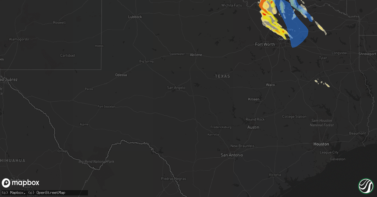
Hail Map in Texas on May 15, 2022
Get this storm
May 15 map
$229
one time, instant access
Download today. No call, no setup
Keep the $229
Bought the map and want the full workflow? Apply the entire $229 to a subscription within 7 days. None of it is wasted.
Every map, not just this one
This buys you this map. Subscription and you get every map we run, in the markets you choose from a few cities to whole states to nationwide. Plus real-time alerts the moment a storm fires.
Contact data
Name, contact info, occupancy, even credit band for addresses in the footprint. You go from where it hit to who to call.
Become the source they trust
Unlimited branding weather history reports on demand. You already have the documented answer ready for the property owner, and you are the one who showed up with it.
Property data and RoofTrace estimates
Pull up any address you have got, its value and the exact code rules for that jurisdiction, straight from One Click Code. Then RoofTrace estimates the squares, pitch, and roof value, priced the way you price.
Storm reports in Texas
Texas
| Date | Description |
|---|---|
| 05/15/20226:58 AM CDT | At 1158 PM CDT, severe thunderstorms were located along a line extending from near Newsome to near Rosewood to near Hawkins to near Hoard, moving southeast at 20 mph. HAZARD...60 mph wind gusts and quarter size hail. SOURCE...Radar indicated. IMPACT...Hail damage to vehicles is expected. Expect wind damage to roofs, siding, and trees. Locations impacted include... Tyler, Longview, Kilgore, White Oak, Gladewater, Gilmer, Pittsburg, Leesburg, Lindale, Big Sandy, Hawkins, Clarksville City, East Mountain, Hainesville, Rosewood, Hoard, Liberty City, Newsome, West Mountain and Winona. |
| 05/15/20226:27 AM CDT | At 1127 PM CDT, a severe thunderstorm was located near Aubrey, or 11 miles north of Lake Lewisville, moving southeast at 35 mph. HAZARD...Quarter size hail. SOURCE...Radar indicated. IMPACT...Damage to vehicles is possible. Locations impacted include... Plano, McKinney, Carrollton, Frisco, Richardson, Lewisville, Allen, Wylie, The Colony, Sachse, Lake Lewisville, Little Elm, Murphy, Prosper, Fairview, Celina, Lucas, Pilot Point, Parker and Aubrey. |
| 05/15/20226:06 AM CDT | At 1105 PM CDT, a severe thunderstorm was located 7 miles northwest of Mount Vernon, or 10 miles southwest of Hagansport, moving southeast at 35 mph. HAZARD...60 mph wind gusts and quarter size hail. SOURCE...Radar indicated. IMPACT...Hail damage to vehicles is expected. Expect wind damage to roofs, siding, and trees. Locations impacted include... Mount Pleasant, Pittsburg, Winnsboro, Leesburg, Mount Vernon, Lone Star, Rosewood, Scroggins, Newsome, Purley, Winfield, Midway, Miller's Cove, Rocky Mound, Perryville, Hopewell, Holly Springs, Monticello, Harvard and Lafayette. |
| 05/15/20226:00 AM CDT | At 1100 PM CDT, a severe thunderstorm was located 10 miles southwest of Hagansport, moving southeast at 35 mph. HAZARD...Quarter size hail. SOURCE...Radar indicated. IMPACT...Damage to vehicles is possible. Locations impacted include... Como and Tira. This includes Interstate 30 between mile markers 130 and 142. |
| 05/15/20225:57 AM CDT | At 1057 PM CDT, severe thunderstorms were located along a line extending from near Burneyville to 3 miles west of Grady, moving southeast at 35 mph. HAZARD...60 mph wind gusts and quarter size hail. SOURCE...Radar indicated. IMPACT...Hail damage to vehicles is expected. Expect wind damage to roofs, siding, and trees. Locations impacted include... Marietta, Ryan, Thackerville, Leon, Grady, Rubottom, Burneyville, Oscar, Courtney and Petersburg. |
| 05/15/20225:41 AM CDT | At 1040 PM CDT, a severe thunderstorm was located 9 miles northwest of Sanger, moving south at 40 mph. HAZARD...Ping pong ball size hail and 60 mph wind gusts. SOURCE...Radar indicated. IMPACT...People and animals outdoors will be injured. Expect hail damage to roofs, siding, windows, and vehicles. Expect wind damage to roofs, siding, and trees. Locations impacted include... Carrollton, Denton, Lewisville, Flower Mound, The Colony, Southlake, Corinth, Highland Village, Trophy Club, Lake Dallas, Sanger, Lake Lewisville, Little Elm, Roanoke, Pecan Acres, Krum, Pilot Point, Argyle, Hickory Creek and Justin.This includes the following highways... Interstate 35 between mile markers 468 and 481. Interstate 35W between mile markers 69 and 85. Interstate 35E between mile markers 446 and 466. |
| 05/15/20225:30 AM CDT | At 1029 PM CDT, severe thunderstorms were located along a line extending from 6 miles south of Campbell to near Royse City, moving southeast at 65 mph. HAZARD...60 mph wind gusts and nickel size hail. SOURCE...Radar indicated. IMPACT...Expect damage to roofs, siding, and trees. Locations impacted include... Dallas, Plano, Garland, Mesquite, McKinney, Frisco, Richardson, Allen, Rowlett, Wylie, Rockwall, Lancaster, Greenville, Balch Springs, Sachse, Terrell, Seagoville, Forney, Commerce and Kaufman.This includes the following highways... Interstate 20 between mile markers 472 and 542. Interstate 30 between mile markers 50 and 109. Interstate 45 between mile markers 267 and 276. |
| 05/15/20225:30 AM CDT | At 1029 PM CDT, a severe thunderstorm was located near Burneyville, moving southeast at 25 mph. HAZARD...60 mph wind gusts and half dollar size hail. SOURCE...Radar indicated. IMPACT...Hail damage to vehicles is expected. Expect wind damage to roofs, siding, and trees. Locations impacted include... Marietta, Thackerville and Burneyville. |
| 05/15/20224:57 AM CDT | At 957 PM CDT, a severe thunderstorm was located 7 miles southeast of Honey Grove, or 17 miles north of Commerce, moving southeast at 45 mph. HAZARD...65 mph wind gusts and quarter size hail. SOURCE...Radar indicated. IMPACT...Hail damage to vehicles is expected. Expect wind damage to roofs, siding, and trees. Locations impacted include... Paris, Sulphur Springs, Cooper, Cumby, Como, Deport, Cooper Lake Park South Sulphur, Cooper Lake Park Doctors Creek, Roxton, Tira, Pecan Gap and Toco.This includes Interstate 30 between mile markers 110 and 142. |
| 05/15/20224:30 AM CDT | At 929 PM CDT, severe thunderstorms were located along a line extending from near Honey Grove to Collinsville, moving south at 40 mph. HAZARD...70 mph wind gusts and ping pong ball size hail. SOURCE...Radar indicated. IMPACT...People and animals outdoors will be injured. Expect hail damage to roofs, siding, windows, and vehicles. Expect considerable tree damage. Wind damage is also likely to mobile homes, roofs, and outbuildings. Locations impacted include... Plano, McKinney, Carrollton, Frisco, Denton, Richardson, Lewisville, Allen, Flower Mound, Wylie, Coppell, Sherman, The Colony, Greenville, Sachse, Corinth, Highland Village, Commerce, Lake Dallas and Lake Lewisville.This includes the following highways... Interstate 35E between mile markers 446 and 458. Interstate 30 between mile markers 81 and 109. |
| 05/15/20222:57 AM CDT | At 757 PM CDT, severe thunderstorms were located along a line extending from 4 miles southeast of Stringtown to 3 miles northwest of Tushka to near Milburn to near Mannsville to near Springer, moving south at 30 mph. HAZARD...Two inch hail and 60 mph wind gusts. SOURCE...Radar indicated. IMPACT...People and animals outdoors will be injured. Expect hail damage to roofs, siding, windows, and vehicles. Expect wind damage to roofs, siding, and trees. Locations impacted include... Ardmore, Durant, Madill, Atoka, Tishomingo, Coalgate, Lone Grove, Kingston, Dickson, Caddo, Mannsville, Springer, Bokchito, Ravia, Wapanucka, Stringtown, Lehigh, Bennington, Silo and Tupelo. |
| 05/15/20222:09 AM CDT | Quarter to half dollar size hail reported 5 miles w of collinsville. |
| 05/15/20222:03 AM CDT | Quarter size hail reported 3 nnw of gainesville. |
| 05/15/20221:50 AM CDT | Report from mping: quarter |
| 05/15/20221:49 AM CDT | Golfball size hail near allen. |
| 05/15/20221:45 AM CDT | *delayed report* reported via mping. |
| 05/15/20221:43 AM CDT | Quarter size hail at custer and mcdermot st. |
| 05/15/20221:33 AM CDT | Report from mping: quarter |
| 05/15/20221:30 AM CDT | Quarter size hail in pilot point. |
| 05/15/20221:25 AM CDT | Report from mping: quarter |
| 05/15/20221:23 AM CDT | Em reports quarter size hail. |
| 05/15/20221:18 AM CDT | Social media report of 1 in hail. |
| 05/15/20221:05 AM CDT | Social media report of 1.25 in hail in aubrey. |
| 05/15/202212:30 AM CDT | Delayed report: quarter size hail measured east of eldorado and preston road intersection. |
| 05/15/202212:12 AM CDT | Tree down at intersection of fm271 and fm726. |
| 05/15/202212:05 AM CDT | Nickel to quarter sized hail at roundrock and parker in plano. |
| 05/15/202212:00 AM CDT | A local report indicates 1.50 inch wind near 3 E THE COLONY |
| 05/15/202212:00 AM CDT | Tree down on fm1002. |
| 05/14/202211:42 PM CDT | *delayed report* reported via mping. |
| 05/14/202211:40 PM CDT | Delayed report: trees uprooted in gun barrel city. |
| 05/14/202211:20 PM CDT | Multiple trees down along naus road. |
| 05/14/202211:20 PM CDT | Roof partially removed from home near the intersection of hwy 37 and county road 3330. |
| 05/14/202211:20 PM CDT | A local report indicates 1.00 inch wind near 1 E KRUM |
| 05/14/202211:17 PM CDT | Trees uprooted. |
| 05/14/202211:14 PM CDT | Numerous trees and tree limbs down all over franklin county. Time estimated from radar. |
| 05/14/202210:49 PM CDT | Trees down throughout ladonia. |
| 05/14/202210:49 PM CDT | A local report indicates 67 MPH wind near 3 W LAWRENCE |
| 05/14/202210:48 PM CDT | Delayed report: emergency manager reports damage to a camper near saltillo. |
| 05/14/202210:45 PM CDT | *delayed report* report from mping: 3-inch tree limbs broken; power poles broken. |
| 05/14/202210:38 PM CDT | Delayed report: emergency manager reports trees down starting near sulphur bluff going south along fm900 towards saltillo. |
| 05/14/202210:35 PM CDT | A local report indicates 64 MPH wind near 3 SE QUINLAN |
| 05/14/202210:28 PM CDT | *delayed report* reported via mping. |
| 05/14/202210:20 PM CDT | *delayed report* reported via mping. |
| 05/14/202210:17 PM CDT | Delayed report: large trees down reported along fm904 in hunt county. |
| 05/14/202210:10 PM CDT | *delayed report* a home sustained damage on fm 64 southeast of pecan gap. The roof was damaged and water entered the home. |
| 05/14/202210:10 PM CDT | *delayed report* a large tree was snapped in half and fell on the end of a manufactured home... Damaging the roof of the home in that area. |
| 05/14/202210:09 PM CDT | Nickel to golf ball sized hail in muenster. |
| 05/14/202210:05 PM CDT | Trees down with power outages reported between bonham and telephone. |
| 05/14/202210:00 PM CDT | *delayed report* the metal covering of a roof was partially peeled off a home. |
| 05/14/20229:50 PM CDT | Very strong straight-line winds associated with a line of severe thunderstorms produced considerable damage over portions of eastern fannin county. The most significant |
| 05/14/20229:50 PM CDT | A local report indicates 1.00 inch wind near 10 N MUENSTER |
| 05/14/20229:48 PM CDT | Delayed report: emergency manager reports powerlines/trees down across grayson county... Multiple calls received by dispatch through late evening. |
| 05/14/20229:41 PM CDT | A local report indicates 62 MPH wind near 4 N HONEY GROVE |
| 05/14/20229:35 PM CDT | Multiple 911 calls reporting trees down on power lines across the city of sherman. |
All States Impacted by Hail Map on May 15, 2022
Cities Impacted by Hail Map on May 15, 2022
- Marshall, IL
- Dennison, IL
- Attica, IN
- Portageville, MO
- Hayti, MO
- Ridgely, TN
- Tiptonville, TN
- Yellville, AR
- Everton, AR
- Bonne Terre, MO
- French Village, MO
- South Greenfield, MO
- Miller, MO
- Sainte Genevieve, MO
- Pleasant Hall, PA
- Orrstown, PA
- Upperstrasburg, PA
- Willow Hill, PA
- Fort Loudon, PA
- Shippensburg, PA
- Fannettsburg, PA
- Chambersburg, PA
- Ellsinore, MO
- Hardinsburg, KY
- Blairs Mills, PA
- Humboldt, TN
- Trenton, TN
- Harned, KY
- Webster, KY
- Kinmundy, IL
- Marshall, AR
- Saint Joe, AR
- Harriet, AR
- Valley Springs, AR
- Western Grove, AR
- Harrison, AR
- Blackwell, MO
- Cadet, MO
- De Soto, MO
- Marshfield, MO
- Rector, AR
- Marmaduke, AR
- Green Forest, AR
- Berryville, AR
- Eureka Springs, AR
- Martinsville, IL
- Hensley, AR
- Mabelvale, AR
- Little Rock, AR
- Malden, MO
- Piggott, AR
- Gideon, MO
- Holcomb, MO
- Clarkton, MO
- Campbell, MO
- Gibson, MO
- Greenway, AR
- Parma, MO
- Caryville, FL
- Cottonwood, AL
- Preston, MS
- Marble Falls, AR
- Oark, AR
- Hagarville, AR
- Clarksville, AR
- Deer, AR
- Jasper, AR
- Ponca, AR
- Huntsville, AR
- Kingston, AR
- Witter, AR
- Pettigrew, AR
- Ozone, AR
- Parthenon, AR
- Alpena, AR
- Compton, AR
- Bigelow, AR
- Salem, IL
- Whitewright, TX
- Savoy, TX
- Bonham, TX
- Ector, TX
- Otterbein, IN
- Atchison, KS
- Pangburn, AR
- Wappapello, MO
- Bristow, OK
- Adams, OR
- Junction City, KS
- Council Grove, KS
- Alma, KS
- Dwight, KS
- Alta Vista, KS
- White City, KS
- Allen, KS
- Fort Riley, KS
- Saint Paul, AR
- West Union, IL
- Oskaloosa, KS
- Dardanelle, AR
- Paris, AR
- Danville, AR
- Havana, AR
- Belleville, AR
- Troy, AL
- Foley, AL
- Sanger, TX
- Sulphur, OK
- Gainesville, TX
- Stonewall, OK
- Lake Dallas, TX
- Wylie, TX
- Collinsville, TX
- Ringling, OK
- Mannsville, OK
- Ada, OK
- Ardmore, OK
- Garland, TX
- Decatur, TX
- Forestburg, TX
- Tioga, TX
- Plano, TX
- Thackerville, OK
- Aubrey, TX
- Saint Jo, TX
- Tishomingo, OK
- Lindsay, TX
- Springer, OK
- Mckinney, TX
- Burneyville, OK
- Little Elm, TX
- Carrollton, TX
- Lavon, TX
- Leon, OK
- Rockwall, TX
- Milburn, OK
- Denton, TX
- Royse City, TX
- Frisco, TX
- The Colony, TX
- Rosston, TX
- Allen, TX
- Overbrook, OK
- Wilson, OK
- Era, TX
- Princeton, TX
- Dallas, TX
- Madill, OK
- Fitzhugh, OK
- Richardson, TX
- Celina, TX
- Marietta, OK
- Muenster, TX
- Whitesboro, TX
- Prosper, TX
- Krum, TX
- Healdton, OK
- Roff, OK
- Mill Creek, OK
- Valley View, TX
- Davis, OK
- Pilot Point, TX
- Lone Grove, OK
- Fayetteville, AR
- Elkins, AR
- Winslow, AR
- Taylorville, IL
- Hartman, AR
- Hickman, KY
- Pineville, MO
- Rogers, AR
- Lowell, AR
- Springdale, AR
- Bentonville, AR
- Bella Vista, AR
- Pea Ridge, AR
- Seligman, MO
- McClure, IL
- Bixby, OK
- Haskell, OK
- Tampa, KS
- Durham, KS
- Marion, KS
- Rossville, TN
- Moscow, TN
- Lamar, AR
- Eagle Rock, MO
- Tahlequah, OK
- Parks, AR
- Etta, MS
- New Albany, MS
- Myrtle, MS
- Bradford, TN
- Perryville, MO
- Saint Mary, MO
- Bainbridge, GA
- Holly Grove, AR
- Howe, TX
- Jackson, AL
- Hornbeak, TN
- Bloomsdale, MO
- Milledgeville, TN
- Morris Chapel, TN
- Grapeland, TX
- Elkhart, TX
- Denham Springs, LA
- Greenwell Springs, LA
- Clinton, LA
- Thorsby, AL
- Booneville, AR
- Sulligent, AL
- Beaverton, AL
- Millport, AL
- Kennedy, AL
- Vernon, AL
- Jacob, IL
- Williamsburg, KS
- Princeton, KS
- Quincy, MO
- Farmington, MO
- Webber, KS
- Dana, IN
- Chrisman, IL
- Cayuga, IN
- Kingman, IN
- Montezuma, IN
- Hillsdale, IN
- Broken Arrow, OK
- Altus, AR
- Coal Hill, AR
- Okmulgee, OK
- Silva, MO
- Patterson, MO
- Greenville, MO
- Lowndes, MO
- Flat Rock, IL
- Strong City, KS
- Hindsville, AR
- Wesley, AR
- Siloam Springs, AR
- Birch Tree, MO
- Hamilton, MS
- Pryor, OK
- Locust Grove, OK
- Chouteau, OK
- Gentry, AR
- Colcord, OK
- Parsons, KS
- Peggs, OK
- Proctor, OK
- Rose, OK
- Summers, AR
- Rudy, AR
- Chester, AR
- Canehill, AR
- Westville, OK
- Van Buren, AR
- Evansville, AR
- Cedarville, AR
- Prairie Grove, AR
- Alma, AR
- Uniontown, AR
- Stilwell, OK
- Lincoln, AR
- Natural Dam, AR
- Mason, IL
- Louisville, IL
- Roland, AR
- Guide Rock, NE
- Superior, NE
- Doniphan, MO
- Breese, IL
- Germantown, IL
- Doe Run, MO
- Mascoutah, IL
- Reading, KS
- Oaktown, IN
- Palestine, IL
- Lockwood, MO
- Golden City, MO
- Manila, AR
- Hulbert, OK
- Wagoner, OK
- Inola, OK
- Montevallo, AL
- Calera, AL
- Robertsdale, AL
- Matthews, MO
- New Madrid, MO
- Harwood, MO
- Walker, MO
- Charleston, MO
- Checotah, OK
- Lavinia, TN
- Milan, TN
- Medina, TN
- Paris, IL
- Robinson, IL
- Veedersburg, IN
- Shell Knob, MO
- Pierce City, MO
- Lampe, MO
- Sarcoxie, MO
- Galena, MO
- Kimberling City, MO
- Ash Grove, MO
- Aurora, MO
- Cassville, MO
- Stotts City, MO
- Monett, MO
- Lamar, MO
- Wentworth, MO
- Cape Fair, MO
- Jasper, MO
- Liberal, MO
- Purdy, MO
- Crane, MO
- La Russell, MO
- Golden, MO
- Blue Eye, MO
- Oak Grove, AR
- Mount Vernon, MO
- Marionville, MO
- Reeds, MO
- Carthage, MO
- Verona, MO
- Freistatt, MO
- Reeds Spring, MO
- Anniston, MO
- East Prairie, MO
- Brundidge, AL
- Louisville, AL
- Banks, AL
- Lyndon, KS
- Quenemo, KS
- Burlingame, KS
- Eskridge, KS
- Lebo, KS
- Harveyville, KS
- Osage City, KS
- Vassar, KS
- Alton, MO
- Cammal, PA
- Valles Mines, MO
- Boynton, OK
- Biscoe, AR
- Williamsport, IN
- West Lebanon, IN
- Centerville, KS
- Greeley, KS
- Garnett, KS
- Parker, KS
- Perrysville, IN
- Covington, IN
- Wingo, KY
- Clinton, KY
- Annapolis, MO
- Lesterville, MO
- Ironton, MO
- Seymour, MO
- Fordland, MO
- Cave Springs, AR
- Chunchula, AL
- Citronelle, AL
- Blytheville, AR
- Ripley, TN
- Hornersville, MO
- Steele, MO
- Luxora, AR
- McIntosh, AL
- Shady Point, OK
- Gans, OK
- Braggs, OK
- Spiro, OK
- Warner, OK
- Sallisaw, OK
- Stigler, OK
- Mccurtain, OK
- Heavener, OK
- Muskogee, OK
- Coweta, OK
- Webbers Falls, OK
- Porum, OK
- Wister, OK
- Oktaha, OK
- Bokoshe, OK
- Howe, OK
- Porter, OK
- Gore, OK
- Poteau, OK
- Muldrow, OK
- Vian, OK
- Cameron, OK
- Keota, OK
- Ashford, AL
- West Point, MS
- Aberdeen, MS
- Columbus, MS
- Crawford, MS
- Fort Walton Beach, FL
- Navarre, FL
- Gulf Breeze, FL
- Defuniak Springs, FL
- Milton, FL
- Eglin Afb, FL
- Niceville, FL
- Freeport, FL
- Valparaiso, FL
- Malvern, AR
- Combs, AR
- Parrish, AL
- Townley, AL
- Carbon Hill, AL
- Jasper, AL
- Oakman, AL
- Berry, AL
- West Blocton, AL
- Brierfield, AL
- Centreville, AL
- Coffeeville, AL
- Gilbertown, AL
- Thomasville, AL
- Toxey, AL
- Needham, AL
- Butler, AL
- Tibbie, AL
- Aliceville, AL
- Macon, MS
- Greenville, TX
- Panama City, FL
- Scooba, MS
- Emelle, AL
- Pattison, MS
- Union Church, MS
- Houston, MS
- Prairie, MS
- Okolona, MS
- McLouth, KS
- Sherman, TX
- Mayersville, MS
- Sondheimer, LA
- Transylvania, LA
- Greenwood, MS
- Oxford, MS
- Pope, MS
- Courtland, MS
- Batesville, MS
- Enid, MS
- Water Valley, MS
- Wells, TX
- Alto, TX
- Irvington, AL
- Buras, LA
- Yates Center, KS
- Hendrix, OK
- El Dorado, KS
- Fort White, FL
- Lake City, FL
- Archer, FL
- Newberry, FL
- Polk City, FL
- Auburndale, FL
- Lake Alfred, FL
- Henning, TN
- Covington, TN
- Coden, AL
- Centrahoma, OK
- Allen, OK
- Tupelo, OK
- Coalgate, OK
- Belle Chasse, LA
- Harvey, LA
- Braithwaite, LA
- Marrero, LA
- Albion, IL
- Hollandale, MS
- Fort Lauderdale, FL
- Pottsboro, TX
- Kingston, OK
- Denison, TX
- Park Hill, OK
- Welling, OK
- Bunch, OK
- Cookson, OK
- Newellton, LA
- Severy, KS
- Eureka, KS
- Somerville, TN
- Mason, TN
- Brighton, TN
- Eldridge, AL
- Nauvoo, AL
- Homestead, FL
- Miami, FL
- Hamilton, KS
- Kenansville, FL
- Saint Cloud, FL
- Diberville, MS
- Biloxi, MS
- Saucier, MS
- Mobile, AL
- Semmes, AL
- Wilmer, AL
- London, AR
- Russellville, AR
- Peabody, KS
- Hillsboro, KS
- Telephone, TX
- Honey Grove, TX
- Summerdale, AL
- Virgil, KS
- Thebes, IL
- Tamms, IL
- Olive Branch, IL
- Oakland, TN
- Clarendon, AR
- Indianola, MS
- Magazine, AR
- Eutaw, AL
- Gordo, AL
- Carrollton, AL
- Maplesville, AL
- Pilot Rock, OR
- Meacham, OR
- Pendleton, OR
- Saltillo, TX
- Sulphur Springs, TX
- Sulphur Bluff, TX
- Cooper, TX
- Mount Vernon, TX
- Scroggins, TX
- Dike, TX
- Lake Creek, TX
- Tallulah, LA
- Cottonwood Falls, KS
- Elmdale, KS
- Saint Johns, FL
- Greenville, AL
- Georgiana, AL
- Searcy, AR
- Holt, FL
- Baker, FL
- Collierville, TN
- Altoona, KS
- Cassoday, KS
- Fall River, KS
- Toronto, KS
- Benedict, KS
- Neal, KS
- Fredonia, KS
- Buffalo, KS
- Madison, KS
- Cedar Point, KS
- Burns, KS
- Matfield Green, KS
- Nahunta, GA
- Hoboken, GA
- Williston, FL
- Bronson, FL
- Hawthorne, FL
- Mineral Point, MO
- Potosi, MO
- Bankston, AL
- Finley, TN
- Okeechobee, FL
- Mcpherson, KS
- Marquette, KS
- Woodbine, GA
- Dover, AR
- Hector, AR
- Daphne, AL
- Ola, AR
- Windom, TX
- Dodd City, TX
- Ivanhoe, TX
- Vinegar Bend, AL
- Molino, FL
- Cantonment, FL
- Loxahatchee, FL
- Pahokee, FL
- Blakely, GA
- Walton, KS
- Vernon, FL
- Hesston, KS
- Windom, KS
- Newton, KS
- Whitewater, KS
- Elbing, KS
- Lindsborg, KS
- Moundridge, KS
- Galva, KS
- Potwin, KS
- Dustin, OK
- Calvin, OK
- Stuart, OK
- Wetumka, OK
- Holdenville, OK
- Okemah, OK
- Lamar, OK
- Weleetka, OK
- Atwood, OK
- Webster, FL
- Belle Glade, FL
- Saint Stephens, AL
- Wagarville, AL
- Kingsland, GA
- Jacksonville, FL
- Okahumpka, FL
- Leesburg, FL
- Gulfport, MS
- Castle, OK
- Canton, KS
- Lehigh, KS
- Belleville, IL
- Lisman, AL
- Cuba, AL
- Park Hills, MO
- Leadwood, MO
- Luverne, AL
- Rutledge, AL
- Plantersville, MS
- Fulton, MS
- Nettleton, MS
- Kansas, OK
- Hamilton, AL
- Caddo Mills, TX
- Harvey, AR
- Gravelly, AR
- Fredericktown, MO
- South Whitley, IN
- Columbia City, IN
- Dadeville, AL
- Jessieville, AR
- Perryville, AR
- Plainview, AR
- Delaware, AR
- Casa, AR
- Pottsville, AR
- Fountain, FL
- Homerville, GA
- Selma, AL
- Marble Hill, MO
- Patton, MO
- Marquand, MO
- De Leon Springs, FL
- Pierson, FL
- Jesup, GA
- Bunnell, FL
- Orange City, FL
- Ava, MO
- Lockwood, NY
- Erin, NY
- Van Etten, NY
- Adamsville, TN
- Caney, OK
- Atoka, OK
- Durant, OK
- Caddo, OK
- Bokchito, OK
- Kenefic, OK
- Wapanucka, OK
- Mead, OK
- Boley, OK
- Coleman, OK
- Calera, OK
- Haines City, FL
- Kissimmee, FL
- Davenport, FL
- Oden, AR
- Glenallen, MO
- Eight Mile, AL
- Lowry City, MO
- Osceola, MO
- Deepwater, MO
- Saraland, AL
- Satsuma, AL
- Bennington, OK
- Rockledge, FL
- Belleview, MO
- Bixby, MO
- Marianna, FL
- Gulf Shores, AL
- Tuskegee, AL
- Fort Davis, AL
- Palestine, TX
- Wellborn, FL
- Live Oak, FL
- Thayer, KS
- Neodesha, KS
- Humboldt, KS
- Emporia, KS
- Gridley, KS
- Hartford, KS
- Inman, KS
- Florence, KS
- Olpe, KS
- Roxbury, KS
- Chanute, KS
- Little River, KS
- Rienzi, MS
- Minter City, MS
- Schlater, MS
- Philipp, MS
- Fort Stewart, GA
- Hinesville, GA
- Pensacola, FL
- Eastpoint, FL
- Caledonia, MO
- Irondale, MO
- Blue Springs, MS
- Saint Thomas, PA
- Hartford, AL
- Daleville, AL
- Fairhope, AL
- Loxley, AL
- Jersey, AR
- Elberta, AL
- Roxton, TX
- Paris, TX
- Brilliant, AL
- Marvell, AR
- Elaine, AR
- Lake Park, GA
- Naylor, GA
- Winfield, AL
- Lucedale, MS
- McDavid, FL
- Natchez, MS
- Tallassee, AL
- Wewahitchka, FL
- Ludowici, GA
- Isola, MS
- Belzoni, MS
- Leroy, AL
- Eclectic, AL
- Alexander City, AL
- Black, AL
- Randolph, AL
- Jacksons Gap, AL
- Altha, FL
- Maple Hill, KS
- Perkinston, MS
- Oakland, MS
- Charleston, MS
- Golden Gate, IL
- Ellery, IL
- Byhalia, MS
- Pine Bluff, AR
- Star City, AR
- Greenwood Springs, MS
- Gattman, MS
- Detroit, AL
- Cowarts, AL
- Webb, AL
- Pansey, AL
- Silverhill, AL
- Pride, LA
- Zachary, LA
- Baker, LA
- Baton Rouge, LA
- Coffeen, IL
- Fillmore, IL
- McCall Creek, MS
- Meadville, MS
- Scott City, MO
- Tillatoba, MS
- Lambert, MS
- Paron, AR
- Alexander, AR
- Benton, AR
- Youngstown, FL
- Garfield, AR
- Sikeston, MO
- Benton, MO
- Seminole, AL
- Garnett, SC
- Ravenna, TX
- De Witt, AR
- Picayune, MS
- Geneva, AL
- Hickory Flat, MS
- Blue Mountain, MS
- Bonifay, FL
- Floral City, FL
- Bushnell, FL
- Van Buren, MO
- Steens, MS
- Caledonia, MS
- Biglerville, PA
- Carlyle, IL
- Centralia, IL
- Sandoval, IL
- Pamplico, SC
- Deer Park, AL
- Bells, TX
- Farmington, AR
- Lester, AL
- Anderson, AL
- Atoka, TN
- Burlison, TN
- Williston, TN
- Stanton, TN
- Munford, TN
- Screven, GA
- Carlisle, IN
- Malone, FL
- Jasper, FL
- Ashland, MS
- Lamar, MS
- Potts Camp, MS
- Aspers, PA
- Hernando, FL
- Dunnellon, FL
- Fort Wayne, IN
- Arlington, TN
- Blue Ridge, TX
- Farmersville, TX
- Celeste, TX
- Mankato, KS
- Manhattan, KS
- Americus, KS
- Riley, KS
- Inverness, MS
- Moorhead, MS
- Sunflower, MS
- Itta Bena, MS
- Satartia, MS
- Yazoo City, MS
- Louise, MS
- Anguilla, MS
- Holly Bluff, MS
- Tchula, MS
- Silver City, MS
- Lexington, MS
- Benton, MS
- Rolling Fork, MS
- Sachse, TX
- Rowlett, TX
- Valley Falls, KS
- Lansing, KS
- Mission, KS
- Silver Lake, KS
- Carbondale, KS
- Delia, KS
- Bonner Springs, KS
- Leawood, KS
- Perry, KS
- Lawrence, KS
- Lees Summit, MO
- Overbrook, KS
- Tecumseh, KS
- Belvue, KS
- Raymore, MO
- Nortonville, KS
- Greenwood, MO
- Lenexa, KS
- Spring Hill, KS
- Shawnee, KS
- Grandview, MO
- Gardner, KS
- Saint George, KS
- Meriden, KS
- Auburn, KS
- Topeka, KS
- Wakarusa, KS
- Eudora, KS
- Pleasant Hill, MO
- Olathe, KS
- Grantville, KS
- Edgerton, KS
- Mayetta, KS
- De Soto, KS
- Kansas City, MO
- Stilwell, KS
- Saint Marys, KS
- McFarland, KS
- Hoyt, KS
- Easton, KS
- Kansas City, KS
- Winchester, KS
- Denison, KS
- Leavenworth, KS
- Berryton, KS
- Overland Park, KS
- Tonganoxie, KS
- New Century, KS
- Bucyrus, KS
- Baldwin City, KS
- Prairie Village, KS
- Paxico, KS
- Wamego, KS
- Belton, MO
- Ozawkie, KS
- Basehor, KS
- Linwood, KS
- Lecompton, KS
- Rossville, KS
- Chapman, KS
- Wakefield, KS
- Milford, KS
- West Fork, AR
- Arcola, IN
- Gretna, LA
- Sumner, TX
- Brookston, TX
- Petty, TX
- Ben Franklin, TX
- Melissa, TX
- Van Alstyne, TX
- Anna, TX
- Point, TX
- Trenton, TX
- Bailey, TX
- Wills Point, TX
- Cumby, TX
- Lebanon, OK
- Cartwright, OK
- Colbert, OK
- Nevada, TX
- Lone Oak, TX
- Forney, TX
- Tom Bean, TX
- Gordonville, TX
- Randolph, TX
- Sadler, TX
- Gunter, TX
- Campbell, TX
- Leonard, TX
- Commerce, TX
- Wolfe City, TX
- Terrell, TX
- Quinlan, TX
- Kaufman, TX
- Bardwell, KY
- Cunningham, KY
- Wickliffe, KY
- Red Oak, OK
- Dougherty, OK


