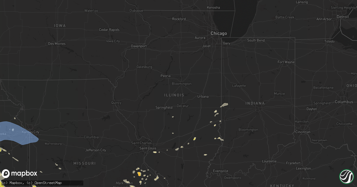
Hail Map in Illinois on May 15, 2022
Get this storm
May 15 map
$229
one time, instant access
Download today. No call, no setup
Keep the $229
Bought the map and want the full workflow? Apply the entire $229 to a subscription within 7 days. None of it is wasted.
Every map, not just this one
This buys you this map. Subscription and you get every map we run, in the markets you choose from a few cities to whole states to nationwide. Plus real-time alerts the moment a storm fires.
Contact data
Name, contact info, occupancy, even credit band for addresses in the footprint. You go from where it hit to who to call.
Become the source they trust
Unlimited branding weather history reports on demand. You already have the documented answer ready for the property owner, and you are the one who showed up with it.
Property data and RoofTrace estimates
Pull up any address you have got, its value and the exact code rules for that jurisdiction, straight from One Click Code. Then RoofTrace estimates the squares, pitch, and roof value, priced the way you price.
Storm reports in Illinois
Illinois
| Date | Description |
|---|---|
| 05/15/20223:54 PM CDT | Videos show a brief tornado touched down west of salem... Il in empty field. Duration likely less than 1 minute... No damage or injuries. |
| 05/15/20221:03 AM CDT | At 602 PM CDT, a severe thunderstorm was located over Lovelaceville, or 9 miles west of Lone Oak, moving northeast at 35 mph. HAZARD...60 mph wind gusts. SOURCE...Radar indicated. IMPACT...Expect damage to roofs, siding, and trees. This severe thunderstorm will be near... Barkley Regional Airport around 610 PM CDT. Paducah, Lone Oak and West Paducah around 615 PM CDT.Other locations in the path of this severe thunderstorm includeReidland.This includes Interstate 24 in Kentucky between Mile Markers 1 and17. |
| 05/14/202211:31 PM CDT | At 431 PM CDT, a severe thunderstorm was located over Iola, or 13 miles northwest of Flora, moving east at 15 mph. HAZARD...60 mph wind gusts and quarter size hail. SOURCE...Radar indicated. IMPACT...Hail damage to vehicles is expected. Expect wind damage to roofs, siding, and trees. Locations impacted include... Bible Grove. |
| 05/14/202210:49 PM CDT | At 349 PM CDT, a severe thunderstorm was located near Bible Grove, or 15 miles north of Flora, moving east at 10 mph. HAZARD...60 mph wind gusts and quarter size hail. SOURCE...Radar indicated. IMPACT...Hail damage to vehicles is expected. Expect wind damage to roofs, siding, and trees. This severe thunderstorm will be near... Bible Grove around 405 PM CDT.This includes Interstate 57 between mile markers 143 and 144. |
| 05/14/202210:47 PM CDT | At 346 PM CDT, a severe thunderstorm was located near Martinsville, or 11 miles west of Marshall, moving northeast at 15 mph. HAZARD...60 mph wind gusts and quarter size hail. SOURCE...Radar indicated. IMPACT...Hail damage to vehicles is expected. Expect wind damage to roofs, siding, and trees. Locations impacted include... Clarksville.This includes Interstate 70 between mile markers 127 and 144. |
| 05/14/202210:35 PM CDT | At 335 PM CDT, severe thunderstorms were located along a line extending from near Chester to near Womac, moving east at 20 mph. HAZARD...60 mph wind gusts and quarter size hail. SOURCE...Radar indicated. IMPACT...Hail damage to vehicles is expected. Expect wind damage to roofs, siding, and trees. Locations impacted include... Perryville.This includes Interstate 55 between Mile Markers 124 and 137. |
All States Impacted by Hail Map on May 15, 2022
Cities Impacted by Hail Map on May 15, 2022
- Marshall, IL
- Dennison, IL
- Attica, IN
- Portageville, MO
- Hayti, MO
- Ridgely, TN
- Tiptonville, TN
- Yellville, AR
- Everton, AR
- Bonne Terre, MO
- French Village, MO
- South Greenfield, MO
- Miller, MO
- Sainte Genevieve, MO
- Pleasant Hall, PA
- Orrstown, PA
- Upperstrasburg, PA
- Willow Hill, PA
- Fort Loudon, PA
- Shippensburg, PA
- Fannettsburg, PA
- Chambersburg, PA
- Ellsinore, MO
- Hardinsburg, KY
- Blairs Mills, PA
- Humboldt, TN
- Trenton, TN
- Harned, KY
- Webster, KY
- Kinmundy, IL
- Marshall, AR
- Saint Joe, AR
- Harriet, AR
- Valley Springs, AR
- Western Grove, AR
- Harrison, AR
- Blackwell, MO
- Cadet, MO
- De Soto, MO
- Marshfield, MO
- Rector, AR
- Marmaduke, AR
- Green Forest, AR
- Berryville, AR
- Eureka Springs, AR
- Martinsville, IL
- Hensley, AR
- Mabelvale, AR
- Little Rock, AR
- Malden, MO
- Piggott, AR
- Gideon, MO
- Holcomb, MO
- Clarkton, MO
- Campbell, MO
- Gibson, MO
- Greenway, AR
- Parma, MO
- Caryville, FL
- Cottonwood, AL
- Preston, MS
- Marble Falls, AR
- Oark, AR
- Hagarville, AR
- Clarksville, AR
- Deer, AR
- Jasper, AR
- Ponca, AR
- Huntsville, AR
- Kingston, AR
- Witter, AR
- Pettigrew, AR
- Ozone, AR
- Parthenon, AR
- Alpena, AR
- Compton, AR
- Bigelow, AR
- Salem, IL
- Whitewright, TX
- Savoy, TX
- Bonham, TX
- Ector, TX
- Otterbein, IN
- Atchison, KS
- Pangburn, AR
- Wappapello, MO
- Bristow, OK
- Adams, OR
- Junction City, KS
- Council Grove, KS
- Alma, KS
- Dwight, KS
- Alta Vista, KS
- White City, KS
- Allen, KS
- Fort Riley, KS
- Saint Paul, AR
- West Union, IL
- Oskaloosa, KS
- Dardanelle, AR
- Paris, AR
- Danville, AR
- Havana, AR
- Belleville, AR
- Troy, AL
- Foley, AL
- Sanger, TX
- Sulphur, OK
- Gainesville, TX
- Stonewall, OK
- Lake Dallas, TX
- Wylie, TX
- Collinsville, TX
- Ringling, OK
- Mannsville, OK
- Ada, OK
- Ardmore, OK
- Garland, TX
- Decatur, TX
- Forestburg, TX
- Tioga, TX
- Plano, TX
- Thackerville, OK
- Aubrey, TX
- Saint Jo, TX
- Tishomingo, OK
- Lindsay, TX
- Springer, OK
- Mckinney, TX
- Burneyville, OK
- Little Elm, TX
- Carrollton, TX
- Lavon, TX
- Leon, OK
- Rockwall, TX
- Milburn, OK
- Denton, TX
- Royse City, TX
- Frisco, TX
- The Colony, TX
- Rosston, TX
- Allen, TX
- Overbrook, OK
- Wilson, OK
- Era, TX
- Princeton, TX
- Dallas, TX
- Madill, OK
- Fitzhugh, OK
- Richardson, TX
- Celina, TX
- Marietta, OK
- Muenster, TX
- Whitesboro, TX
- Prosper, TX
- Krum, TX
- Healdton, OK
- Roff, OK
- Mill Creek, OK
- Valley View, TX
- Davis, OK
- Pilot Point, TX
- Lone Grove, OK
- Fayetteville, AR
- Elkins, AR
- Winslow, AR
- Taylorville, IL
- Hartman, AR
- Hickman, KY
- Pineville, MO
- Rogers, AR
- Lowell, AR
- Springdale, AR
- Bentonville, AR
- Bella Vista, AR
- Pea Ridge, AR
- Seligman, MO
- McClure, IL
- Bixby, OK
- Haskell, OK
- Tampa, KS
- Durham, KS
- Marion, KS
- Rossville, TN
- Moscow, TN
- Lamar, AR
- Eagle Rock, MO
- Tahlequah, OK
- Parks, AR
- Etta, MS
- New Albany, MS
- Myrtle, MS
- Bradford, TN
- Perryville, MO
- Saint Mary, MO
- Bainbridge, GA
- Holly Grove, AR
- Howe, TX
- Jackson, AL
- Hornbeak, TN
- Bloomsdale, MO
- Milledgeville, TN
- Morris Chapel, TN
- Grapeland, TX
- Elkhart, TX
- Denham Springs, LA
- Greenwell Springs, LA
- Clinton, LA
- Thorsby, AL
- Booneville, AR
- Sulligent, AL
- Beaverton, AL
- Millport, AL
- Kennedy, AL
- Vernon, AL
- Jacob, IL
- Williamsburg, KS
- Princeton, KS
- Quincy, MO
- Farmington, MO
- Webber, KS
- Dana, IN
- Chrisman, IL
- Cayuga, IN
- Kingman, IN
- Montezuma, IN
- Hillsdale, IN
- Broken Arrow, OK
- Altus, AR
- Coal Hill, AR
- Okmulgee, OK
- Silva, MO
- Patterson, MO
- Greenville, MO
- Lowndes, MO
- Flat Rock, IL
- Strong City, KS
- Hindsville, AR
- Wesley, AR
- Siloam Springs, AR
- Birch Tree, MO
- Hamilton, MS
- Pryor, OK
- Locust Grove, OK
- Chouteau, OK
- Gentry, AR
- Colcord, OK
- Parsons, KS
- Peggs, OK
- Proctor, OK
- Rose, OK
- Summers, AR
- Rudy, AR
- Chester, AR
- Canehill, AR
- Westville, OK
- Van Buren, AR
- Evansville, AR
- Cedarville, AR
- Prairie Grove, AR
- Alma, AR
- Uniontown, AR
- Stilwell, OK
- Lincoln, AR
- Natural Dam, AR
- Mason, IL
- Louisville, IL
- Roland, AR
- Guide Rock, NE
- Superior, NE
- Doniphan, MO
- Breese, IL
- Germantown, IL
- Doe Run, MO
- Mascoutah, IL
- Reading, KS
- Oaktown, IN
- Palestine, IL
- Lockwood, MO
- Golden City, MO
- Manila, AR
- Hulbert, OK
- Wagoner, OK
- Inola, OK
- Montevallo, AL
- Calera, AL
- Robertsdale, AL
- Matthews, MO
- New Madrid, MO
- Harwood, MO
- Walker, MO
- Charleston, MO
- Checotah, OK
- Lavinia, TN
- Milan, TN
- Medina, TN
- Paris, IL
- Robinson, IL
- Veedersburg, IN
- Shell Knob, MO
- Pierce City, MO
- Lampe, MO
- Sarcoxie, MO
- Galena, MO
- Kimberling City, MO
- Ash Grove, MO
- Aurora, MO
- Cassville, MO
- Stotts City, MO
- Monett, MO
- Lamar, MO
- Wentworth, MO
- Cape Fair, MO
- Jasper, MO
- Liberal, MO
- Purdy, MO
- Crane, MO
- La Russell, MO
- Golden, MO
- Blue Eye, MO
- Oak Grove, AR
- Mount Vernon, MO
- Marionville, MO
- Reeds, MO
- Carthage, MO
- Verona, MO
- Freistatt, MO
- Reeds Spring, MO
- Anniston, MO
- East Prairie, MO
- Brundidge, AL
- Louisville, AL
- Banks, AL
- Lyndon, KS
- Quenemo, KS
- Burlingame, KS
- Eskridge, KS
- Lebo, KS
- Harveyville, KS
- Osage City, KS
- Vassar, KS
- Alton, MO
- Cammal, PA
- Valles Mines, MO
- Boynton, OK
- Biscoe, AR
- Williamsport, IN
- West Lebanon, IN
- Centerville, KS
- Greeley, KS
- Garnett, KS
- Parker, KS
- Perrysville, IN
- Covington, IN
- Wingo, KY
- Clinton, KY
- Annapolis, MO
- Lesterville, MO
- Ironton, MO
- Seymour, MO
- Fordland, MO
- Cave Springs, AR
- Chunchula, AL
- Citronelle, AL
- Blytheville, AR
- Ripley, TN
- Hornersville, MO
- Steele, MO
- Luxora, AR
- McIntosh, AL
- Shady Point, OK
- Gans, OK
- Braggs, OK
- Spiro, OK
- Warner, OK
- Sallisaw, OK
- Stigler, OK
- Mccurtain, OK
- Heavener, OK
- Muskogee, OK
- Coweta, OK
- Webbers Falls, OK
- Porum, OK
- Wister, OK
- Oktaha, OK
- Bokoshe, OK
- Howe, OK
- Porter, OK
- Gore, OK
- Poteau, OK
- Muldrow, OK
- Vian, OK
- Cameron, OK
- Keota, OK
- Ashford, AL
- West Point, MS
- Aberdeen, MS
- Columbus, MS
- Crawford, MS
- Fort Walton Beach, FL
- Navarre, FL
- Gulf Breeze, FL
- Defuniak Springs, FL
- Milton, FL
- Eglin Afb, FL
- Niceville, FL
- Freeport, FL
- Valparaiso, FL
- Malvern, AR
- Combs, AR
- Parrish, AL
- Townley, AL
- Carbon Hill, AL
- Jasper, AL
- Oakman, AL
- Berry, AL
- West Blocton, AL
- Brierfield, AL
- Centreville, AL
- Coffeeville, AL
- Gilbertown, AL
- Thomasville, AL
- Toxey, AL
- Needham, AL
- Butler, AL
- Tibbie, AL
- Aliceville, AL
- Macon, MS
- Greenville, TX
- Panama City, FL
- Scooba, MS
- Emelle, AL
- Pattison, MS
- Union Church, MS
- Houston, MS
- Prairie, MS
- Okolona, MS
- McLouth, KS
- Sherman, TX
- Mayersville, MS
- Sondheimer, LA
- Transylvania, LA
- Greenwood, MS
- Oxford, MS
- Pope, MS
- Courtland, MS
- Batesville, MS
- Enid, MS
- Water Valley, MS
- Wells, TX
- Alto, TX
- Irvington, AL
- Buras, LA
- Yates Center, KS
- Hendrix, OK
- El Dorado, KS
- Fort White, FL
- Lake City, FL
- Archer, FL
- Newberry, FL
- Polk City, FL
- Auburndale, FL
- Lake Alfred, FL
- Henning, TN
- Covington, TN
- Coden, AL
- Centrahoma, OK
- Allen, OK
- Tupelo, OK
- Coalgate, OK
- Belle Chasse, LA
- Harvey, LA
- Braithwaite, LA
- Marrero, LA
- Albion, IL
- Hollandale, MS
- Fort Lauderdale, FL
- Pottsboro, TX
- Kingston, OK
- Denison, TX
- Park Hill, OK
- Welling, OK
- Bunch, OK
- Cookson, OK
- Newellton, LA
- Severy, KS
- Eureka, KS
- Somerville, TN
- Mason, TN
- Brighton, TN
- Eldridge, AL
- Nauvoo, AL
- Homestead, FL
- Miami, FL
- Hamilton, KS
- Kenansville, FL
- Saint Cloud, FL
- Diberville, MS
- Biloxi, MS
- Saucier, MS
- Mobile, AL
- Semmes, AL
- Wilmer, AL
- London, AR
- Russellville, AR
- Peabody, KS
- Hillsboro, KS
- Telephone, TX
- Honey Grove, TX
- Summerdale, AL
- Virgil, KS
- Thebes, IL
- Tamms, IL
- Olive Branch, IL
- Oakland, TN
- Clarendon, AR
- Indianola, MS
- Magazine, AR
- Eutaw, AL
- Gordo, AL
- Carrollton, AL
- Maplesville, AL
- Pilot Rock, OR
- Meacham, OR
- Pendleton, OR
- Saltillo, TX
- Sulphur Springs, TX
- Sulphur Bluff, TX
- Cooper, TX
- Mount Vernon, TX
- Scroggins, TX
- Dike, TX
- Lake Creek, TX
- Tallulah, LA
- Cottonwood Falls, KS
- Elmdale, KS
- Saint Johns, FL
- Greenville, AL
- Georgiana, AL
- Searcy, AR
- Holt, FL
- Baker, FL
- Collierville, TN
- Altoona, KS
- Cassoday, KS
- Fall River, KS
- Toronto, KS
- Benedict, KS
- Neal, KS
- Fredonia, KS
- Buffalo, KS
- Madison, KS
- Cedar Point, KS
- Burns, KS
- Matfield Green, KS
- Nahunta, GA
- Hoboken, GA
- Williston, FL
- Bronson, FL
- Hawthorne, FL
- Mineral Point, MO
- Potosi, MO
- Bankston, AL
- Finley, TN
- Okeechobee, FL
- Mcpherson, KS
- Marquette, KS
- Woodbine, GA
- Dover, AR
- Hector, AR
- Daphne, AL
- Ola, AR
- Windom, TX
- Dodd City, TX
- Ivanhoe, TX
- Vinegar Bend, AL
- Molino, FL
- Cantonment, FL
- Loxahatchee, FL
- Pahokee, FL
- Blakely, GA
- Walton, KS
- Vernon, FL
- Hesston, KS
- Windom, KS
- Newton, KS
- Whitewater, KS
- Elbing, KS
- Lindsborg, KS
- Moundridge, KS
- Galva, KS
- Potwin, KS
- Dustin, OK
- Calvin, OK
- Stuart, OK
- Wetumka, OK
- Holdenville, OK
- Okemah, OK
- Lamar, OK
- Weleetka, OK
- Atwood, OK
- Webster, FL
- Belle Glade, FL
- Saint Stephens, AL
- Wagarville, AL
- Kingsland, GA
- Jacksonville, FL
- Okahumpka, FL
- Leesburg, FL
- Gulfport, MS
- Castle, OK
- Canton, KS
- Lehigh, KS
- Belleville, IL
- Lisman, AL
- Cuba, AL
- Park Hills, MO
- Leadwood, MO
- Luverne, AL
- Rutledge, AL
- Plantersville, MS
- Fulton, MS
- Nettleton, MS
- Kansas, OK
- Hamilton, AL
- Caddo Mills, TX
- Harvey, AR
- Gravelly, AR
- Fredericktown, MO
- South Whitley, IN
- Columbia City, IN
- Dadeville, AL
- Jessieville, AR
- Perryville, AR
- Plainview, AR
- Delaware, AR
- Casa, AR
- Pottsville, AR
- Fountain, FL
- Homerville, GA
- Selma, AL
- Marble Hill, MO
- Patton, MO
- Marquand, MO
- De Leon Springs, FL
- Pierson, FL
- Jesup, GA
- Bunnell, FL
- Orange City, FL
- Ava, MO
- Lockwood, NY
- Erin, NY
- Van Etten, NY
- Adamsville, TN
- Caney, OK
- Atoka, OK
- Durant, OK
- Caddo, OK
- Bokchito, OK
- Kenefic, OK
- Wapanucka, OK
- Mead, OK
- Boley, OK
- Coleman, OK
- Calera, OK
- Haines City, FL
- Kissimmee, FL
- Davenport, FL
- Oden, AR
- Glenallen, MO
- Eight Mile, AL
- Lowry City, MO
- Osceola, MO
- Deepwater, MO
- Saraland, AL
- Satsuma, AL
- Bennington, OK
- Rockledge, FL
- Belleview, MO
- Bixby, MO
- Marianna, FL
- Gulf Shores, AL
- Tuskegee, AL
- Fort Davis, AL
- Palestine, TX
- Wellborn, FL
- Live Oak, FL
- Thayer, KS
- Neodesha, KS
- Humboldt, KS
- Emporia, KS
- Gridley, KS
- Hartford, KS
- Inman, KS
- Florence, KS
- Olpe, KS
- Roxbury, KS
- Chanute, KS
- Little River, KS
- Rienzi, MS
- Minter City, MS
- Schlater, MS
- Philipp, MS
- Fort Stewart, GA
- Hinesville, GA
- Pensacola, FL
- Eastpoint, FL
- Caledonia, MO
- Irondale, MO
- Blue Springs, MS
- Saint Thomas, PA
- Hartford, AL
- Daleville, AL
- Fairhope, AL
- Loxley, AL
- Jersey, AR
- Elberta, AL
- Roxton, TX
- Paris, TX
- Brilliant, AL
- Marvell, AR
- Elaine, AR
- Lake Park, GA
- Naylor, GA
- Winfield, AL
- Lucedale, MS
- McDavid, FL
- Natchez, MS
- Tallassee, AL
- Wewahitchka, FL
- Ludowici, GA
- Isola, MS
- Belzoni, MS
- Leroy, AL
- Eclectic, AL
- Alexander City, AL
- Black, AL
- Randolph, AL
- Jacksons Gap, AL
- Altha, FL
- Maple Hill, KS
- Perkinston, MS
- Oakland, MS
- Charleston, MS
- Golden Gate, IL
- Ellery, IL
- Byhalia, MS
- Pine Bluff, AR
- Star City, AR
- Greenwood Springs, MS
- Gattman, MS
- Detroit, AL
- Cowarts, AL
- Webb, AL
- Pansey, AL
- Silverhill, AL
- Pride, LA
- Zachary, LA
- Baker, LA
- Baton Rouge, LA
- Coffeen, IL
- Fillmore, IL
- McCall Creek, MS
- Meadville, MS
- Scott City, MO
- Tillatoba, MS
- Lambert, MS
- Paron, AR
- Alexander, AR
- Benton, AR
- Youngstown, FL
- Garfield, AR
- Sikeston, MO
- Benton, MO
- Seminole, AL
- Garnett, SC
- Ravenna, TX
- De Witt, AR
- Picayune, MS
- Geneva, AL
- Hickory Flat, MS
- Blue Mountain, MS
- Bonifay, FL
- Floral City, FL
- Bushnell, FL
- Van Buren, MO
- Steens, MS
- Caledonia, MS
- Biglerville, PA
- Carlyle, IL
- Centralia, IL
- Sandoval, IL
- Pamplico, SC
- Deer Park, AL
- Bells, TX
- Farmington, AR
- Lester, AL
- Anderson, AL
- Atoka, TN
- Burlison, TN
- Williston, TN
- Stanton, TN
- Munford, TN
- Screven, GA
- Carlisle, IN
- Malone, FL
- Jasper, FL
- Ashland, MS
- Lamar, MS
- Potts Camp, MS
- Aspers, PA
- Hernando, FL
- Dunnellon, FL
- Fort Wayne, IN
- Arlington, TN
- Blue Ridge, TX
- Farmersville, TX
- Celeste, TX
- Mankato, KS
- Manhattan, KS
- Americus, KS
- Riley, KS
- Inverness, MS
- Moorhead, MS
- Sunflower, MS
- Itta Bena, MS
- Satartia, MS
- Yazoo City, MS
- Louise, MS
- Anguilla, MS
- Holly Bluff, MS
- Tchula, MS
- Silver City, MS
- Lexington, MS
- Benton, MS
- Rolling Fork, MS
- Sachse, TX
- Rowlett, TX
- Valley Falls, KS
- Lansing, KS
- Mission, KS
- Silver Lake, KS
- Carbondale, KS
- Delia, KS
- Bonner Springs, KS
- Leawood, KS
- Perry, KS
- Lawrence, KS
- Lees Summit, MO
- Overbrook, KS
- Tecumseh, KS
- Belvue, KS
- Raymore, MO
- Nortonville, KS
- Greenwood, MO
- Lenexa, KS
- Spring Hill, KS
- Shawnee, KS
- Grandview, MO
- Gardner, KS
- Saint George, KS
- Meriden, KS
- Auburn, KS
- Topeka, KS
- Wakarusa, KS
- Eudora, KS
- Pleasant Hill, MO
- Olathe, KS
- Grantville, KS
- Edgerton, KS
- Mayetta, KS
- De Soto, KS
- Kansas City, MO
- Stilwell, KS
- Saint Marys, KS
- McFarland, KS
- Hoyt, KS
- Easton, KS
- Kansas City, KS
- Winchester, KS
- Denison, KS
- Leavenworth, KS
- Berryton, KS
- Overland Park, KS
- Tonganoxie, KS
- New Century, KS
- Bucyrus, KS
- Baldwin City, KS
- Prairie Village, KS
- Paxico, KS
- Wamego, KS
- Belton, MO
- Ozawkie, KS
- Basehor, KS
- Linwood, KS
- Lecompton, KS
- Rossville, KS
- Chapman, KS
- Wakefield, KS
- Milford, KS
- West Fork, AR
- Arcola, IN
- Gretna, LA
- Sumner, TX
- Brookston, TX
- Petty, TX
- Ben Franklin, TX
- Melissa, TX
- Van Alstyne, TX
- Anna, TX
- Point, TX
- Trenton, TX
- Bailey, TX
- Wills Point, TX
- Cumby, TX
- Lebanon, OK
- Cartwright, OK
- Colbert, OK
- Nevada, TX
- Lone Oak, TX
- Forney, TX
- Tom Bean, TX
- Gordonville, TX
- Randolph, TX
- Sadler, TX
- Gunter, TX
- Campbell, TX
- Leonard, TX
- Commerce, TX
- Wolfe City, TX
- Terrell, TX
- Quinlan, TX
- Kaufman, TX
- Bardwell, KY
- Cunningham, KY
- Wickliffe, KY
- Red Oak, OK
- Dougherty, OK


