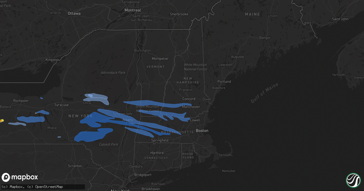
Hail Map in Vermont on May 15, 2020
Get this storm
May 15 map
$229
one time, instant access
Download today. No call, no setup
Keep the $229
Bought the map and want the full workflow? Apply the entire $229 to a subscription within 7 days. None of it is wasted.
Every map, not just this one
This buys you this map. Subscription and you get every map we run, in the markets you choose from a few cities to whole states to nationwide. Plus real-time alerts the moment a storm fires.
Contact data
Name, contact info, occupancy, even credit band for addresses in the footprint. You go from where it hit to who to call.
Become the source they trust
Unlimited branding weather history reports on demand. You already have the documented answer ready for the property owner, and you are the one who showed up with it.
Property data and RoofTrace estimates
Pull up any address you have got, its value and the exact code rules for that jurisdiction, straight from One Click Code. Then RoofTrace estimates the squares, pitch, and roof value, priced the way you price.
Storm reports in Vermont
Vermont
| Date | Description |
|---|---|
| 05/15/20206:25 PM CDT | Downed power lines and trees |
| 05/15/20206:20 PM CDT | Route 142 closed south of newton rd closed due to trees and wires down. Time estimated by radar. |
| 05/15/20206:16 PM CDT | Trees and wires were down on guilford street |
| 05/15/20206:16 PM CDT | Multiple trees and wires down in dummerston |
| 05/15/20206:15 PM CDT | Tree down on road. Scattered tree limbs down. |
| 05/15/20206:11 PM CDT | Trees down along knapp brook road and knapp pond road. Barn damaged on senna road. Time estimated by radar. |
| 05/15/20206:08 PM CDT | Tree down on powerline along tinkham hill road. Time estimated by radar. |
| 05/15/20206:04 PM CDT | Two moderate size trees down across route 35 |
| 05/15/20205:48 PM CDT | Tree and wires down on carpenter hill road |
| 05/15/20205:47 PM CDT | Trees down on both sides of route 100 between granville and warren falls. Time estimated by radar. |
| 05/15/20205:37 PM CDT | Several large branches up to 25 feet long down along carlen street |
| 05/15/20205:33 PM CDT | Powerlines were downed |
| 05/15/20205:27 PM CDT | Trees were downed on route 313 |
| 05/15/20205:26 PM CDT | Four downed birch trees 12-18 feet in diameter on west sandgate road |
| 05/15/20205:25 PM CDT | Trees were downed on route 313 |
| 05/15/20202:37 AM CDT | At 736 PM EDT, severe thunderstorms were located along a line extending from near Newport to near Roxbury to near Winchester, moving east at 50 mph. HAZARD...70 mph wind gusts and penny size hail. SOURCE...Radar indicated. IMPACT...Expect considerable tree damage. Damage is likely to mobile homes, roofs, and outbuildings. Locations impacted include... Nashua, Keene, Jaffrey, Henniker, Merrimack, Bedford, Milford, Amherst, Hollis, Peterborough, Hopkinton, New Boston, Winchester, Antrim, Mont Vernon, Greenfield, Lyndeborough, Bradford, Dublin and Francestown.This includes Interstate 89 between mile markers 8 and 20. This also includes... Mount Monadnock and North Pack Monadnock. |
| 05/15/20202:16 AM CDT | At 715 PM EDT, severe thunderstorms were located along a line extending from 9 miles northeast of Hanover to 10 miles northwest of Claremont, moving east at 50 mph. HAZARD...60 mph wind gusts and penny size hail. SOURCE...Radar indicated. IMPACT...Expect damage to roofs, siding, and trees. Locations impacted include... Claremont, Lebanon, New London, Plymouth, Grafton, Hanover, Charlestown, Enfield, Canaan, Holderness, Ashland, Danbury, Groton, Newport, Warner, Bristol, Grantham, Andover, Lyme and Cornish.This includes the following highways... Interstate 89 between mile markers 24 and 60. Interstate 93 between mile markers 75 and 90.This also includes... Rumney Rocks, Mount Kearsage, Carr Mountain, Stinson Mountain, andMount Sunapee. |
| 05/15/20201:59 AM CDT | At 658 PM EDT, severe thunderstorms were located along a line extending from near Pownal to near New Baltimore, moving east at 50 mph. HAZARD...60 mph wind gusts and penny size hail. SOURCE...Radar indicated. IMPACT...Expect damage to roofs, siding, and trees. Locations impacted include... Nassau, Stephentown, New Lebanon, Berlin, Valatie, Kinderhook, Averill Park, Sand Lake, Canaan, East Nassau, Van Hoesen Station, West Stephentown, Jacks Corners, Millers Corners, Rayville, Riders Mills, Taborton, Center Berlin, Petersburg and South Schodack. |
| 05/15/20201:47 AM CDT | At 647 PM EDT, a severe thunderstorm was located near Berlin, or 9 miles west of North Adams, moving east at 55 mph. HAZARD...60 mph wind gusts and penny size hail. SOURCE...Radar indicated. IMPACT...Expect damage to roofs, siding, and trees. Locations impacted include... Pittsfield, North Adams, Adams, Williamstown, Cheshire, Florida, Hancock, Savoy, New Ashford, Berkshire, Dalton, Lanesborough, Hinsdale, Windsor, Peru, Hairpin Turn, Barkerville, Greylock, Soldiers Memorial Field and North Hancock. |
| 05/15/20201:22 AM CDT | At 622 PM EDT, severe thunderstorms were located along a line extending from near Mechanicville to near Westerlo, moving east at 60 mph. HAZARD...60 mph wind gusts and penny size hail. SOURCE...Radar indicated. IMPACT...Expect damage to roofs, siding, and trees. Locations impacted include... Albany, Schenectady, Troy, Clifton Park, Rotterdam, East Greenbush, Cohoes, Watervliet, Rensselaer, Colonie, Nassau, Delmar, Latham, Guilderland, Niskayuna, Menands, New Baltimore, Westerlo, Ravena and Stephentown. |
All States Impacted by Hail Map on May 15, 2020
Cities Impacted by Hail Map on May 15, 2020
- Ellsworth, NE
- Anadarko, OK
- Big Spring, TX
- Santa Anna, TX
- Santa Fe, TX
- Dickinson, TX
- Paducah, TX
- Sterling City, TX
- Midland, TX
- Tahoka, TX
- Lawton, OK
- Wichita Falls, TX
- Batesville, TX
- Electra, TX
- Bluff Dale, TX
- Stephenville, TX
- Andrews, TX
- Muskogee, OK
- Longton, KS
- Clayton, NM
- Crystal City, TX
- Throckmorton, TX
- Seymour, TX
- Poteau, OK
- Hartford, AR
- Cameron, OK
- Garden City, TX
- Mason, TX
- Comfort, TX
- Goldsmith, TX
- Odessa, TX
- Breckenridge, TX
- Comanche, TX
- Taft, TX
- Davis, OK
- Hennepin, OK
- Elmore City, OK
- Poteet, TX
- Charlotte, TX
- Bigfoot, TX
- Wilson, TX
- Hebbronville, TX
- Realitos, TX
- Armstrong, TX
- Linn, TX
- Fort Sill, OK
- Sonora, TX
- Snyder, TX
- Lamesa, TX
- Ramah, CO
- Simla, CO
- Calhan, CO
- Eads, CO
- Haswell, CO
- Caddo, TX
- Ranger, TX
- Gans, OK
- Muldrow, OK
- Keota, OK
- Spiro, OK
- Ackerly, TX
- Center Point, TX
- Kerrville, TX
- Medina, TX
- Bandera, TX
- Falls City, TX
- Hobson, TX
- Karnes City, TX
- Moran, TX
- Cisco, TX
- Sallisaw, OK
- Dublin, TX
- De Leon, TX
- Dalhart, TX
- Graham, TX
- Altus, OK
- Gore, OK
- Mountain View, OK
- Floresville, TX
- Fredericksburg, TX
- Mena, AR
- Turkey, TX
- Loving, TX
- Olney, TX
- Uvalde, TX
- Knippa, TX
- Lampasas, TX
- San Saba, TX
- Childress, TX
- Weatherford, TX
- Leesville, TX
- Nixon, TX
- Bay City, TX
- Palacios, TX
- Elmaton, TX
- Crowell, TX
- Wagon Mound, NM
- Seminole, TX
- Kenedy, TX
- Bishop, TX
- Altus Afb, OK
- Headrick, OK
- Mountain Park, OK
- Snyder, OK
- Tipton, OK
- Hyannis, NE
- Yuma, CO
- Matador, TX
- La Pryor, TX
- Mertzon, TX
- Blanco, TX
- Hye, TX
- Johnson City, TX
- Roosevelt, OK
- Murfreesboro, AR
- Nashville, AR
- Wanette, OK
- Lexington, OK
- Pipe Creek, TX
- Fluvanna, TX
- Mullen, NE
- Hico, TX
- Hondo, TX
- Strykersville, NY
- Varysburg, NY
- Foster, OK
- Delight, AR
- Lometa, TX
- Goldthwaite, TX
- Stanton, TX
- Oshkosh, NE
- Ashby, NE
- Lamar, OK
- Dustin, OK
- Mingus, TX
- San Antonio, TX
- Encino, TX
- Elmer, OK
- Cyril, OK
- Fletcher, OK
- Ninnekah, OK
- Apache, OK
- Chickasha, OK
- Elgin, OK
- Marlow, OK
- Rush Springs, OK
- Cement, OK
- Chillicothe, TX
- Flomot, TX
- Girard, TX
- Marathon, TX
- Woodson, TX
- Lakeside, NE
- Boerne, TX
- Davidson, OK
- Odonnell, TX
- Kendalia, TX
- Canyon Lake, TX
- Spring Branch, TX
- Robstown, TX
- Keenesburg, CO
- Akron, CO
- Cotulla, TX
- Encinal, TX
- Laredo, TX
- Del Valle, TX
- Duncan, OK
- Holliday, TX
- Rising Star, TX
- Quanah, TX
- Okolona, AR
- Arkadelphia, AR
- Sweetwater, TX
- Blackwell, TX
- New Braunfels, TX
- Cherokee, TX
- Tow, TX
- Llano, TX
- Vernon, TX
- Channing, TX
- Comstock, TX
- Carnegie, OK
- Sweeny, TX
- Jourdanton, TX
- Campo, CO
- Loveland, OK
- Grandfield, OK
- Frederick, OK
- Bend, TX
- Sandia, TX
- Matagorda, TX
- Brady, TX
- Pottsville, TX
- Galveston, TX
- Kingsville, TX
- Edinburg, TX
- Concan, TX
- Corpus Christi, TX
- Big Lake, TX
- Cuero, TX
- Yoakum, TX
- Pampa, TX
- Miami, TX
- Pearsall, TX
- Moore, TX
- Hallettsville, TX
- Tarzan, TX
- Sidney, NE
- Flagler, CO
- Seibert, CO
- Gorman, TX
- Jacksonville, TX
- Guerra, TX
- Carlsbad, TX
- Del Rio, TX
- Hudson, CO
- Roggen, CO
- Edna, TX
- Freer, TX
- Tilden, TX
- Rocksprings, TX
- Stockdale, TX
- Zapata, TX
- Garciasville, TX
- Gardendale, TX
- Sabinal, TX
- Owanka, SD
- Stratford, TX
- Sulphur, OK
- Tyler, TX
- Lindale, TX
- Rockdale, TX
- Iowa Park, TX
- Burkburnett, TX
- Huntington, AR
- Booneville, AR
- Mansfield, AR
- Greenwood, AR
- Austin, TX
- Midland, AR
- Hackett, AR
- Utopia, TX
- Bokoshe, OK
- Shady Point, OK
- East Concord, NY
- Holland, NY
- Chaffee, NY
- Cross Plains, TX
- Justiceburg, TX
- Cedar Creek, TX
- Wynnewood, OK
- Horseshoe Bay, TX
- Kingsland, TX
- Gail, TX
- Post, TX
- Coahoma, TX
- San Angelo, TX
- Orange Grove, TX
- Alice, TX
- Boulder, CO
- Lafayette, CO
- Longmont, CO
- Erie, CO
- Robert Lee, TX
- Three Rivers, TX
- Campbellton, TX
- Brackettville, TX
- Strawn, TX
- Graford, TX
- Elgin, TX
- Whitsett, TX
- Glenwood, NY
- Braggs, OK
- Eldorado, TX
- Limon, CO
- Matheson, CO
- McCaskill, AR
- Barnhart, TX
- Bangs, TX
- Mounds, OK
- Sapulpa, OK
- Eufaula, OK
- Rio Grande City, TX
- Amber, OK
- Blanchard, OK
- Blevins, AR
- Lenorah, TX
- Castroville, TX
- Newcastle, TX
- Dryden, TX
- Harrold, TX
- Oklaunion, TX
- Southlake, TX
- Leakey, TX
- Ganado, TX
- North Java, NY
- Bliss, NY
- Frederick, CO
- Firestone, CO
- Meadow, TX
- Plain Dealing, LA
- Emerson, AR
- Pleasanton, TX
- Runge, TX
- Yorktown, TX
- Ecleto, TX
- Gillett, TX
- Mirando City, TX
- Whitman, NE
- Quinton, OK
- Stigler, OK
- Alex, OK
- Gustine, TX
- Cache, OK
- Indiahoma, OK
- Chattanooga, OK
- Morris, OK
- Okmulgee, OK
- Haskell, OK
- Odell, TX
- Olustee, OK
- Eldorado, OK
- Hollister, OK
- Colorado City, TX
- Gonzales, TX
- Fort Lupton, CO
- Kirk, CO
- Burlington, CO
- Idalia, CO
- Kanorado, KS
- Wallis, TX
- Magnolia, AR
- Severy, KS
- Piedmont, KS
- Maysville, OK
- Wayne, OK
- Purcell, OK
- Santo, TX
- Von Ormy, TX
- Somerset, TX
- Gainesville, NY
- Eastland, TX
- Westbrook, TX
- Jayton, TX
- D Hanis, TX
- Randlett, OK
- Cost, TX
- Dayton, TX
- Stanley, NY
- Sidney, TX
- Carbon, TX
- Mullin, TX
- Council Hill, OK
- Noble, OK
- Concepcion, TX
- Kemp, TX
- Yancey, TX
- Bartlesville, OK
- Mission, TX
- Cedar Park, TX
- Alvin, TX
- Liverpool, TX
- Dacono, CO
- Delaware, OK
- Hamilton, TX
- Buchanan Dam, TX
- Bluffton, TX
- Wrightsboro, TX
- Hugo, CO
- Quemado, TX
- Eagle Pass, TX
- Vona, CO
- League City, TX
- Texas City, TX
- Port Lavaca, TX
- Manor, TX
- Desdemona, TX
- Evant, TX
- Asherton, TX
- El Dorado, KS
- Leon, KS
- Raton, NM
- Falfurrias, TX
- Round Mountain, TX
- Ira, TX
- Ballinger, TX
- Coleman, TX
- Iredell, TX
- Boynton, OK
- Oktaha, OK
- Kaufman, TX
- Terrell, TX
- Seadrift, TX
- Walters, OK
- Sheppard Afb, TX
- Cherryvale, KS
- Dubberly, LA
- Macomb, OK
- Meridian, TX
- Cranfills Gap, TX
- Clifton, TX
- Jonesboro, TX
- Rio Frio, TX
- Mathis, TX
- Calliham, TX
- Lindsay, OK
- Carrizo Springs, TX
- Crosbyton, TX
- Seguin, TX
- Woodrow, CO
- Waldron, AR
- Mcalester, OK
- Ozona, TX
- Baird, TX
- Roland, OK
- Burnet, TX
- Rusk, TX
- Hunt, TX
- Nordheim, TX
- Wolfforth, TX
- Willow City, TX
- Ralls, TX
- Dumas, TX
- Karval, CO
- Royse City, TX
- Atascosa, TX
- Newkirk, OK
- Haynesville, LA
- Grulla, TX
- Warner, OK
- Bastrop, TX
- Palo Pinto, TX
- Rowena, TX
- Taft, OK
- Oden, AR
- Byers, TX
- Lewisville, TX
- Premont, TX
- Arcade, NY
- Benton, LA
- Lipan, TX
- Devine, TX
- Archer City, TX
- Cedar Vale, KS
- Grenola, KS
- Loraine, TX
- Cameron, TX
- Buckholts, TX
- Smiley, TX
- Lindon, CO
- Cope, CO
- Goliad, TX
- Mineral Wells, TX
- Bradley, OK
- Temple, OK
- Forney, TX
- New Underwood, SD
- Winchester, NH
- Maryneal, TX
- Beeville, TX
- Howard, KS
- Hanna, OK
- Peyton, CO
- Spur, TX
- Stinnett, TX
- Van Vleck, TX
- Mccurtain, OK
- Marion, TX
- Tulsa, OK
- Ozan, AR
- Whitefield, OK
- Gotebo, OK
- George West, TX
- Henryetta, OK
- Crandall, TX
- Deer Trail, CO
- Denton, TX
- Sinton, TX
- Pocola, OK
- Heavener, OK
- Jacksboro, TX
- Aransas Pass, TX
- Rockport, TX
- Texline, TX
- Carlton, TX
- Barksdale, TX
- Portland, TX
- Houston, TX
- Nowata, OK
- Mineola, TX
- Victoria, TX
- Jenks, OK
- Kingsbury, TX
- Hobart, OK
- Fort Cobb, OK
- Geronimo, OK
- Woodsboro, TX
- Howe, OK
- Alpine, TX
- Crane, TX
- Monahans, TX
- Luling, TX
- Java Center, NY
- Mcadoo, TX
- Roaring Springs, TX
- Roscoe, TX
- Lohn, TX
- Miles, TX
- Paint Rock, TX
- Eola, TX
- Vancourt, TX
- Gouldbusk, TX
- Doole, TX
- Millersview, TX
- Voss, TX
- Wall, TX
- Eden, TX
- Christoval, TX
- Mereta, TX
- Zephyr, TX
- Valera, TX
- Brownwood, TX
- Blanket, TX
- May, TX
- Early, TX
- Brookesmith, TX
- Talpa, TX
- Dilley, TX
- Laughlin Afb, TX
- Big Wells, TX
- Trent, TX
- McCaulley, TX
- Hamlin, TX
- Merkel, TX
- Sylvester, TX
- Hawley, TX
- Abilene, TX
- Anson, TX
- Dyess Afb, TX
- Nolan, TX
- Tye, TX
- Henrietta, TX
- Petrolia, TX
- Ringgold, TX
- Bellevue, TX
- Devol, OK
- Windthorst, TX
- Bowie, TX
- Sunset, TX
- Chico, TX
- Gordon, TX
- Tarpley, TX
- Bulverde, TX
- Stonewall, TX
- Bergheim, TX
- Bertram, TX
- Catarina, TX
- Tolar, TX
- Granbury, TX
- Shiner, TX
- Cleburne, TX
- Skidmore, TX
- San Diego, TX
- El Campo, TX
- Garwood, TX
- Damon, TX
- Guy, TX
- Glen Flora, TX
- Needville, TX
- Louise, TX
- Boling, TX
- Wharton, TX
- Sugar Land, TX
- Rosenberg, TX
- Richmond, TX
- Eagle Lake, TX
- Alleyton, TX
- Fulshear, TX
- Columbus, TX
- Sealy, TX
- East Bernard, TX
- Manvel, TX
- Stafford, TX
- Rosharon, TX
- Missouri City, TX
- Pearland, TX
- Fresno, TX
- Vian, OK
- Webbers Falls, OK
- Medicine Park, OK
- Dalton, NY
- Canaseraga, NY
- Cohocton, NY
- Hunt, NY
- Dansville, NY
- Nunda, NY
- Wayland, NY
- Swain, NY
- Portageville, NY
- Romulus, NY
- Prattsburgh, NY
- Keuka Park, NY
- Naples, NY
- Conesus, NY
- Scottsburg, NY
- Branchport, NY
- Dresden, NY
- Lodi, NY
- Ovid, NY
- Springwater, NY
- Penn Yan, NY
- Groveland, NY
- Interlaken, NY
- Middlesex, NY
- Himrod, NY
- Rushville, NY
- Honeoye, NY
- North Rose, NY
- Wolcott, NY
- Geneva, NY
- Cayuga, NY
- Scipio Center, NY
- Aurora, NY
- Seneca Falls, NY
- Waterloo, NY
- Union Springs, NY
- Fayette, NY
- Newport, NY
- Poland, NY
- Remsen, NY
- Little Falls, NY
- Salisbury Center, NY
- Barneveld, NY
- Caroga Lake, NY
- Holland Patent, NY
- Stratford, NY
- Hoffmeister, NY
- Prospect, NY
- Cold Brook, NY
- Oriskany, NY
- Rome, NY
- Marcy, NY
- Johnstown, NY
- Dolgeville, NY
- Middleville, NY
- Utica, NY
- Whitesboro, NY
- Saint Johnsville, NY
- Gloversville, NY
- Owego, NY
- Newark Valley, NY
- Endicott, NY
- Candor, NY
- Grand Gorge, NY
- Windham, NY
- Nineveh, NY
- Stamford, NY
- Delancey, NY
- Hancock, NY
- Gilboa, NY
- Denver, NY
- Roxbury, NY
- Afton, NY
- Deposit, NY
- Sidney Center, NY
- Windsor, NY
- Hobart, NY
- Harpursville, NY
- Masonville, NY
- Sidney, NY
- Bloomville, NY
- Franklin, NY
- Halcottsville, NY
- Margaretville, NY
- New Kingston, NY
- Ouaquaga, NY
- Ashland, NY
- Unadilla, NY
- Bainbridge, NY
- Delhi, NY
- Bovina Center, NY
- Andes, NY
- Hamden, NY
- Walton, NY
- East Branch, NY
- South Kortright, NY
- Downsville, NY
- Prattsville, NY
- Voorheesville, NY
- Hinsdale, MA
- New Lisbon, NY
- Worcester, NY
- East Berne, NY
- Hartwick, NY
- Chesterfield, MA
- Stephentown, NY
- West Burlington, NY
- Berne, NY
- New Lebanon, NY
- Canaan, NY
- Ravena, NY
- Schoharie, NY
- Howes Cave, NY
- Dalton, MA
- Burlington Flats, NY
- Clarksville, NY
- Northampton, MA
- Sharon Springs, NY
- Westerlo, NY
- Leeds, MA
- Westford, NY
- Becket, MA
- Chester, MA
- Selkirk, NY
- Warren, MA
- West Oneonta, NY
- East Chatham, NY
- Fly Creek, NY
- Florence, MA
- Oneonta, NY
- East Meredith, NY
- Warnerville, NY
- Worthington, MA
- Middlefield, MA
- Otego, NY
- Middleburgh, NY
- Edmeston, NY
- Richmondville, NY
- Ware, MA
- Brainard, NY
- Mount Vision, NY
- Davenport, NY
- West Chesterfield, MA
- Fultonham, NY
- Davenport Center, NY
- Norwich, NY
- Belchertown, MA
- Feura Bush, NY
- New Berlin, NY
- Delmar, NY
- Milford, NY
- Hadley, MA
- Southampton, MA
- Lenox, MA
- Maryland, NY
- Sherburne, NY
- Richfield Springs, NY
- West Davenport, NY
- East Nassau, NY
- Laurens, NY
- Nassau, NY
- South Bethlehem, NY
- Pittsfield, MA
- Garrattsville, NY
- Old Chatham, NY
- Springfield Center, NY
- Cherry Valley, NY
- South New Berlin, NY
- Coeymans Hollow, NY
- Glenmont, NY
- Roseboom, NY
- Schodack Landing, NY
- Easthampton, MA
- Castleton On Hudson, NY
- Cobleskill, NY
- Schenevus, NY
- Granby, MA
- Delanson, NY
- Charlotteville, NY
- Portlandville, NY
- Jefferson, NY
- Central Bridge, NY
- Summit, NY
- East Worcester, NY
- Huntington, MA
- South Hadley, MA
- Morris, NY
- Holyoke, MA
- Cooperstown, NY
- New Boston, NH
- Dunbarton, NH
- Antrim, NH
- Shushan, NY
- Wardsboro, VT
- Manchester, VT
- Schuylerville, NY
- Saratoga Springs, NY
- Goffstown, NH
- Stoddard, NH
- Hancock, NH
- Keene, NH
- Greenwich, NY
- Westmoreland, NH
- Bondville, VT
- Alstead, NH
- Eagle Bridge, NY
- Manchester Center, VT
- Walpole, NH
- Hooksett, NH
- Weare, NH
- Greenfield, NH
- Gilsum, NH
- Gansevoort, NY
- Arlington, VT
- Putney, VT
- Marlborough, NH
- North Bennington, VT
- Victory Mills, NY
- Stillwater, NY
- Cambridge, NY
- Newfane, VT
- Sullivan, NH
- Townshend, VT
- Jamaica, VT
- Bennington, NH
- Chester, VT
- Greenfield Center, NY
- Nelson, NH
- Westminster, VT
- Harrisville, NH
- Shaftsbury, VT
- Hillsborough, NH
- East Arlington, VT
- Francestown, NH
- Salem, NY
- Manchester, NH
- West Townshend, VT
- West Wardsboro, VT
- South Deerfield, MA
- Shutesbury, MA
- Palatine Bridge, NY
- North Hatfield, MA
- West Sand Lake, NY
- Guilderland, NY
- North Brookfield, MA
- Amherst, MA
- Wynantskill, NY
- New Braintree, MA
- East Schodack, NY
- Fonda, NY
- Sunderland, MA
- Haydenville, MA
- Petersburg, NY
- Gilbertville, MA
- Troy, NY
- Leicester, MA
- Williamsburg, MA
- Latham, NY
- East Greenbush, NY
- Rensselaer, NY
- Slingerlands, NY
- Sloansville, NY
- Amsterdam, NY
- Fort Plain, NY
- Berkshire, MA
- Hatfield, MA
- Averill Park, NY
- Sand Lake, NY
- Cummington, MA
- Schenectady, NY
- Altamont, NY
- Poestenkill, NY
- Spencer, MA
- Esperance, NY
- Paxton, MA
- Shelburne Falls, MA
- Hardwick, MA
- Carlisle, NY
- Ashfield, MA
- Conway, MA
- Goshen, MA
- Sprakers, NY
- Pattersonville, NY
- Cheshire, MA
- Oakham, MA
- Windsor, MA
- Fultonville, NY
- Jordanville, NY
- Rutland, MA
- Plainfield, MA
- Worcester, MA
- Savoy, MA
- Canajoharie, NY
- Van Hornesville, NY
- South Barre, MA
- Watervliet, NY
- Duanesburg, NY
- Williamstown, MA
- Albany, NY
- West Hatfield, MA
- Lanesborough, MA
- Barre, MA
- Charlemont, MA
- Leverett, MA
- Brookline, NH
- Readsboro, VT
- West Chesterfield, NH
- Pepperell, MA
- Ashby, MA
- Ashburnham, MA
- Jacksonville, VT
- Chesterfield, NH
- Bernardston, MA
- Wilton, NH
- Greenville, NH
- Whitingham, VT
- West Townsend, MA
- Stamford, VT
- Royalston, MA
- Fitchburg, MA
- Brattleboro, VT
- West Halifax, VT
- Northfield, MA
- Gill, MA
- Ashuelot, NH
- Shirley, MA
- Swanzey, NH
- Hoosick Falls, NY
- Jaffrey, NH
- Warwick, MA
- Troy, NH
- Lunenburg, MA
- Peterborough, NH
- Wilmington, VT
- Fitzwilliam, NH
- Rindge, NH
- New Ipswich, NH
- Bennington, VT
- Winchendon, MA
- Milford, NH
- Townsend, MA
- Hinsdale, NH
- Temple, NH
- Vernon, VT
- Pownal, VT
- Groton, MA
- Dunstable, MA
- Hannacroix, NY
- Austerlitz, NY
- Stuyvesant, NY
- Spencertown, NY
- Westfield, MA
- Ghent, NY
- West Stockbridge, MA
- Stockbridge, MA
- South Lee, MA
- Lenox Dale, MA
- Blandford, MA
- Chatham, NY
- West Coxsackie, NY
- Tyringham, MA
- Valatie, NY
- Kinderhook, NY
- Richmond, MA
- Russell, MA
- Housatonic, MA
- Otis, MA
- Lee, MA


