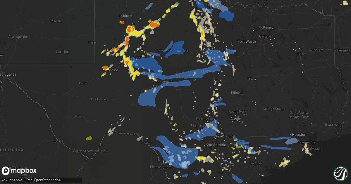
Hail Map in Texas on May 15, 2020
Get this storm
May 15 map
$229
one time, instant access
Download today. No call, no setup
Keep the $229
Bought the map and want the full workflow? Apply the entire $229 to a subscription within 7 days. None of it is wasted.
Every map, not just this one
This buys you this map. Subscription and you get every map we run, in the markets you choose from a few cities to whole states to nationwide. Plus real-time alerts the moment a storm fires.
Contact data
Name, contact info, occupancy, even credit band for addresses in the footprint. You go from where it hit to who to call.
Become the source they trust
Unlimited branding weather history reports on demand. You already have the documented answer ready for the property owner, and you are the one who showed up with it.
Property data and RoofTrace estimates
Pull up any address you have got, its value and the exact code rules for that jurisdiction, straight from One Click Code. Then RoofTrace estimates the squares, pitch, and roof value, priced the way you price.
Storm reports in Texas
Texas
| Date | Description |
|---|---|
| 05/15/20206:34 PM CDT | Via mping. |
| 05/15/20206:33 PM CDT | A local report indicates 1.00 inch wind near 5 S DAVIDSON |
| 05/15/20206:19 PM CDT | Mping report |
| 05/15/20206:15 PM CDT | 64 mph wind gust recorded at the ozona awos at 6:15 pm cdt. |
| 05/15/20206:10 PM CDT | Severe wind gust measured at 61 mph from trained spotter. |
| 05/15/20206:05 PM CDT | Severe wind gust along i-20... Flipping a semi-trailer. Gust estimated to 75 mph or greater. |
| 05/15/20206:03 PM CDT | Social media report with pictures of a church steeple blown over. Time estimated from radar. |
| 05/15/20206:02 PM CDT | Observer reported ping pong ball to hen egg sized hail which flattened his winter wheat crop. Time estimated from radar. |
| 05/15/20206:01 PM CDT | Mesonet site recorded a 64 mph wind gust at 6:01 pm cdt. This mesonet is located 5 miles west of rotan. |
| 05/15/20206:00 PM CDT | A local report indicates 1.25 inch wind near 10 W QUANAH |
| 05/15/20206:00 PM CDT | A local report indicates 60 MPH wind near 3 N ROARING SPRINGS |
| 05/15/20206:00 PM CDT | A local report indicates 67 MPH wind near 5 SW ST. LAWRENCE |
| 05/15/20206:00 PM CDT | A local report indicates 64 MPH wind near 2 NNE CHILDRESS |
| 05/15/20205:55 PM CDT | A local report indicates 61 MPH wind near 2 NNE CHILDRESS |
| 05/15/20205:46 PM CDT | Social media report with pictures of two power poles snapped due to straight line winds. Time estimated from radar. |
| 05/15/20205:44 PM CDT | A local report indicates 59 MPH wind near 3 NNW MCADOO |
| 05/15/20205:33 PM CDT | Public reports high wind. |
| 05/15/20205:32 PM CDT | Mping report |
| 05/15/20205:30 PM CDT | Large healthy tree blown down... Damaging a truck |
| 05/15/20205:30 PM CDT | A local report indicates 1.50 inch wind near 2 SE FOLLEY |
| 05/15/20205:29 PM CDT | Wind damage with doors ripped off metal barn. Wind speed estimated at 65-70 mph. Time estimated by radar. |
| 05/15/20205:10 PM CDT | A local report indicates 59 MPH wind near 6 NW WHITE RIVER LAKE |
| 05/15/20204:59 PM CDT | A local report indicates 68 MPH wind near 1 SSE LOMAX |
| 05/15/20204:55 PM CDT | Wind damage to mutiple fences... With 70 mph wind gust estimated. |
| 05/15/20204:45 PM CDT | A local report indicates 60 MPH wind near 1 SSE JAYTON |
| 05/15/20204:38 PM CDT | Estimated winds of 60-70 mph with lots of rain reducing visibility to near 0 miles. |
| 05/15/20204:32 PM CDT | A local report indicates 1.75 inch wind near STANTON |
| 05/15/20204:19 PM CDT | Mping report |
| 05/15/20204:05 PM CDT | A local report indicates 1.25 inch wind near STANTON |
| 05/15/20203:59 PM CDT | A local report indicates 1.25 inch wind near STANTON |
| 05/15/20203:59 PM CDT | West odessa |
| 05/15/20203:10 PM CDT | A local report indicates 1.50 inch wind near SPARENBERG |
| 05/15/20206:57 AM CDT | At 1157 PM CDT, severe thunderstorms were located along a line extending from 7 miles northwest of Nell to near Whitsett to 12 miles northeast of Fort Ewell Site, moving east at 30 mph. HAZARD...60 mph wind gusts and penny size hail. SOURCE...Radar indicated. IMPACT...Expect damage to roofs, siding, and trees. Locations impacted include... George West, Three Rivers, Tilden, Choke Canyon, Cross, Fort Ewell Site, River Creek Acres, Artesia Wells, Calliham, Zella, Karon, Pawnee, Simmons, Ray Point, Mineral, Loma Alta, Fowlerton, Nell, Oakville and Crowther. |
| 05/15/20206:54 AM CDT | At 1153 PM CDT, a severe thunderstorm was located 10 miles west of Falls City, or 12 miles southwest of Poth, moving east at 40 mph. HAZARD...60 mph wind gusts and quarter size hail. SOURCE...Radar indicated. IMPACT...Hail damage to vehicles is expected. Expect wind damage to roofs, siding, and trees. Locations impacted include... Floresville, Kenedy, Karnes City, Poth, Yorktown, Stockdale, Kosciusko, Runge, Falls City, Nordheim, Gillett, Cestohowa, Westhoff, Coy City, Cotton Patch, Choate, Fashing, El Oso, Ecleto, and Helena. |
| 05/15/20206:48 AM CDT | An ef-1 tornado with max wind speeds of 100 mph touched down south of mauriceville along hwy 62... And continued northeast across fm1130 and hwy 12 before ending along |
| 05/15/20206:45 AM CDT | At 1145 PM CDT, a severe thunderstorm was located near El Cenizo, or 12 miles south of Laredo, moving east at 25 mph. HAZARD...60 mph wind gusts and penny size hail. SOURCE...Radar indicated. IMPACT...Expect damage to roofs, siding, and trees. Locations impacted include... Laredo, Rio Bravo, El Cenizo, Laredo International Airport, Ranchitos Las Lomas, St Augustine High School South Laredo, Laredo Community College, United South High School and Texas A&M International University. |
| 05/15/20206:31 AM CDT | At 1131 PM CDT, a severe thunderstorm was located over Ranchos Penitas West, or 8 miles northwest of Laredo, moving northeast at 45 mph. HAZARD...60 mph wind gusts and penny size hail. SOURCE...Radar indicated. IMPACT...Expect damage to roofs, siding, and trees. Locations impacted include... Laredo, Encinal, Botines, Unitec Industrial Park, Doctors Hospital Of Laredo, Laredo Country Club, Ranchos Penitas West, Orvil, Columbia Bridge and Callaghan. |
| 05/15/20206:27 AM CDT | Roof removed on tanglewood drive. Time estimated by radar. |
| 05/15/20206:12 AM CDT | At 1112 PM CDT, a severe thunderstorm was located near Zella, or 19 miles southeast of Dilley, moving southeast at 40 mph. HAZARD...70 mph wind gusts and penny size hail. SOURCE...Radar indicated. IMPACT...Expect considerable tree damage. Damage is likely to mobile homes, roofs, and outbuildings. Locations impacted include... Choke Canyon, Tilden, Calliham, Loma Alta, Cross, Zella, Fowlerton, Crowther, Los Angeles, Whitsett, Esseville and Simmons. |
| 05/15/20206:10 AM CDT | At 1109 PM CDT, a cluster of severe thunderstorms was located from near Glen Rose to Evant, moving northeast at 35 mph. HAZARD...60 mph wind gusts. SOURCE...Radar indicated. IMPACT...Expect damage to roofs, siding, and trees. Locations impacted include... Gatesville, McGregor, Clifton, Hamilton, Meridian, Hico, Valley Mills, Crawford, Iredell, Cranfills Gap, Meridian State Park, Gholson, Walnut Springs, Morgan, Oglesby and South Mountain. |
| 05/15/20205:58 AM CDT | At 1057 PM CDT, a severe thunderstorm was located 9 miles southeast of Encinal, moving southeast at 45 mph. HAZARD...60 mph wind gusts and penny size hail. SOURCE...Radar indicated. IMPACT...Expect damage to roofs, siding, and trees. Locations impacted include... Big Wells, Asherton, Chaparral Wildlife Management Area, Light, Catarina, Las Vegas, Carrizo Hill, and Brundage. |
| 05/15/20205:55 AM CDT | At 1053 PM CDT, a severe thunderstorm was located over Charlotte, moving east at 40 mph. HAZARD...60 mph wind gusts and nickel size hail. SOURCE...Radar indicated. IMPACT...Expect damage to roofs, siding, and trees. Locations impacted include... Pleasanton, Floresville, Jourdanton, Poteet, Poth, Charlotte, Stockdale, Christine, Campbellton, Lytle, Somerset, Elmendorf, Natalia, Falls City, Goldfinch, Calaveras Lake, Leming, Schattel, Bigfoot, and Sandy Oaks. |
| 05/15/20205:41 AM CDT | At 1041 PM CDT, severe thunderstorms were located along a line extending from near Dilley to near Woodward to near Catarina, moving southeast at 25 mph. HAZARD...60 mph wind gusts and penny size hail. SOURCE...Radar indicated. IMPACT...Expect damage to roofs, siding, and trees. Locations impacted include... Cotulla, Gardendale, Woodward, Millett, Los Angeles, Artesia Wells and Chaparral Wildlife Management Area. |
| 05/15/20205:31 AM CDT | At 1031 PM CDT, severe thunderstorms were located along a line extending from 6 miles north of Tow to near Twin Sisters to Cross Mountain to Quihi, moving east at 30 mph. HAZARD...60 mph wind gusts and quarter size hail. SOURCE...Radar indicated. IMPACT...Hail damage to vehicles is expected. Expect wind damage to roofs, siding, and trees. Locations impacted include... San Antonio, Austin, New Braunfels, Cedar Park, San Marcos, Schertz, Cibolo, Universal City, Live Oak, Boerne, Selma, Burnet, Marble Falls, Kingsland, Dripping Springs, Castroville, Wimberley, Blanco, Bertram and Round Mountain. |
| 05/15/20205:28 AM CDT | At 1027 PM CDT, a line of severe thunderstorms was located from near Mineral Wells to Stephenville, moving east at 30 mph. HAZARD...60 mph wind gusts and penny size hail. SOURCE...Radar indicated. IMPACT...Expect damage to roofs, siding, and trees. Locations impacted include... Weatherford, Granbury, Briar, Pecan Plantation, Willow Park, Reno, Aledo, Springtown, Glen Rose, Hudson Oaks, Annetta, Lipan, Dinosaur Valley State Park, Oak Trail Shores, Tolar, Annetta South, Annetta North and Sanctuary.This includes the following highways... Interstate 20 between mile markers 395 and 422. |
| 05/15/20205:15 AM CDT | At 1015 PM CDT, a severe thunderstorm was located 19 miles southeast of Spearman, moving northeast at 10 mph. HAZARD...Half dollar size hail. SOURCE...Radar indicated. IMPACT...Damage to vehicles is expected. This severe thunderstorm will remain over mainly rural areas of northwestern Roberts and southwestern Ochiltree Counties. |
| 05/15/20205:00 AM CDT | At 1000 PM CDT, a severe thunderstorm was located 12 miles north of Chupadera Ranch Airport, or 14 miles southeast of El Indio, moving east at 50 mph. HAZARD...60 mph wind gusts and penny size hail. SOURCE...Radar indicated. IMPACT...Expect damage to roofs, siding, and trees. Locations impacted include... Gilson Groves. |
| 05/15/20204:59 AM CDT | At 959 PM CDT, a severe thunderstorm was located over Old Tunnel State Park, or 12 miles northeast of Comfort, moving northwest at 15 mph. HAZARD...60 mph wind gusts and quarter size hail. SOURCE...Radar indicated. IMPACT...Hail damage to vehicles is expected. Expect wind damage to roofs, siding, and trees. Locations impacted include... Fredericksburg, Stonewall, Sisterdale, Kendalia, Blumenthal, Luckenbach, Cain City, Old Tunnel State Park, Waring, Rocky Hill, Grapetown and Bankersmith. |
| 05/15/20204:58 AM CDT | At 956 PM CDT, a severe thunderstorm was located near Las Vegas, or 7 miles east of Big Wells, moving southeast at 30 mph. HAZARD...60 mph wind gusts and quarter size hail. SOURCE...Radar indicated. IMPACT...Hail damage to vehicles is expected. Expect wind damage to roofs, siding, and trees. Locations impacted include... Cotulla, Millett, Gardendale, Artesia Wells, Woodward and Chaparral Wildlife Management Area. |
| 05/15/20204:57 AM CDT | At 957 PM CDT, severe thunderstorms were located along a line extending from 7 miles north of Jacksboro to near Gordon, moving east at 30 mph. HAZARD...60 mph wind gusts and penny size hail. SOURCE...Radar indicated. IMPACT...Expect damage to roofs, siding, and trees. Locations impacted include... Mineral Wells, Bridgeport, Jacksboro, Alvord, Chico, Graford, Gordon, Cool, Poolville, Boonsville, Mineral Wells State Park, Runaway Bay, Strawn, Millsap, Lake Bridgeport and Mingus.This includes Interstate 20 between mile markers 370 and 403. |
| 05/15/20204:57 AM CDT | At 956 PM CDT, a severe thunderstorm was located near Asherton, or 8 miles southwest of Big Wells, moving southeast at 45 mph. HAZARD...60 mph wind gusts and penny size hail. SOURCE...Radar indicated. IMPACT...Expect damage to roofs, siding, and trees. Locations impacted include... Big Wells, Asherton, Brundage, Chaparral Wildlife Management Area, Light, Carrizo Hill, Catarina, and Las Vegas. |
| 05/15/20204:54 AM CDT | At 953 PM CDT, a severe thunderstorm was located near Frio Town, or 16 miles northwest of Pearsall, moving east at 40 mph. HAZARD...60 mph wind gusts and penny size hail. SOURCE...Radar indicated. IMPACT...Expect damage to roofs, siding, and trees. Locations impacted include... San Antonio, Pearsall, Hondo, Devine, Dilley, Castroville, Lytle, Somerset, Natalia, Lacoste, North Pearsall, Moore, Goldfinch, D'Hanis, Hilltop, Noonan, Quihi, Dunlay, Pearson, and Bader. |
| 05/15/20204:49 AM CDT | At 949 PM CDT, a severe thunderstorm was located 7 miles southeast of Ranger, moving east at 25 mph. HAZARD...60 mph wind gusts. SOURCE...Radar indicated. IMPACT...Expect damage to roofs, siding, and trees. Locations impacted include... Stephenville, Eastland, Dublin, Ranger, De Leon, Gorman, Huckabay, Morgan Mill and Carbon.This includes Interstate 20 between mile markers 340 and 368. |
| 05/15/20204:46 AM CDT | At 945 PM CDT, a severe thunderstorm was located 6 miles southeast of Conlen, or 13 miles southwest of Stratford, moving east at 20 mph. HAZARD...Quarter size hail. SOURCE...Radar indicated. IMPACT...Damage to vehicles is expected. Locations impacted include... Stratford, Cactus and Conlen. |
| 05/15/20204:43 AM CDT | At 943 PM CDT, a severe thunderstorm was located 4 miles northwest of Lake Meredith, or 17 miles west of Borger, moving north at 30 mph. HAZARD...Half dollar size hail. SOURCE...Radar indicated. IMPACT...Damage to vehicles is expected. Locations impacted include... Borger, Fritch, Sunray, Stinnett, Sanford, Lake Meredith and Pringle. |
| 05/15/20204:32 AM CDT | At 931 PM CDT, a severe thunderstorm was located near Bandera, moving east at 20 mph. HAZARD...60 mph wind gusts. SOURCE...Radar indicated. IMPACT...Expect damage to roofs, siding, and trees. Locations impacted include... Boerne, Bandera, Walnut Grove, Lakehills, Bandera Falls, Government Canyon State Natural Area, Pipe Creek, Welfare, Nelson City, Kronkosky State Natural Area, Camp Verde, San Geronimo, and Lake Medina Shores. |
| 05/15/20204:28 AM CDT | At 927 PM CDT, a severe thunderstorm was located 8 miles southeast of Rochelle, or 10 miles southwest of Richland Springs, moving east at 45 mph. HAZARD...60 mph wind gusts. SOURCE...Radar indicated. IMPACT...Expect damage to roofs, siding, and trees. This severe thunderstorm will be near... Richland Springs and Sloan around 940 PM CDT. Algerita around 945 PM CDT. San Saba around 955 PM CDT. Chappel around 1010 PM CDT.Other locations impacted by this severe thunderstorm includeHarkeyville, Milburn, Locker, Spring Creek, Us-190 Near The Mcculloch-San Saba County Line, Hall and Us-190 Near The San Saba-Lampasas County Line. |
| 05/15/20204:17 AM CDT | At 917 PM CDT, a severe thunderstorm was located near Brownwood, moving northeast at 25 mph. HAZARD...60 mph wind gusts. SOURCE...Trained weather spotters reported wind damage in Brownwood. IMPACT...Expect damage to roofs, siding, and trees. Locations impacted include... Brownwood, Early, Bangs, Blanket, Lake Brownwood Near Thrifty, May, Cross Cut, Lake Brownwood, Winchell, Zephyr, Brookesmith, Byrds, Grosvenor, Lake Brownwood State Park, Camp Bowie, Owens, Thrifty and Indian Creek. |
| 05/15/20204:12 AM CDT | At 910 PM CDT, severe thunderstorms were located along a line extending from 3 miles west of Waurika Lake to 4 miles southeast of Petrolia to 5 miles south of Windthorst, moving east at 25 mph. HAZARD...60 mph wind gusts and quarter size hail. SOURCE...A weather observation station in Wichita Falls recorded a 60 mph wind gust at 852 PM. Numerous reports of wind damage were also reported by trained spotters in Archer City at 810 PM. IMPACT...Hail damage to vehicles is expected. Expect wind damage to roofs, siding, and trees. Locations impacted include... Henrietta, Waurika, Ryan, Petrolia, Byers, Windthorst, Terral, Bellevue, Hastings, Addington, Sugden, Newport, Lake Arrowhead, southern Waurika Lake, Bluegrove, Shannon, Joy and Vashti. |
| 05/15/20204:12 AM CDT | At 911 PM CDT, severe thunderstorms were located along a line extending from 11 miles east of Olney to near Necessity to near Cross Cut, moving east at 35 mph. HAZARD...60 mph wind gusts and quarter size hail. SOURCE...Radar indicated. IMPACT...Hail damage to vehicles is expected. Expect wind damage to roofs, siding, and trees. Locations impacted include... Mineral Wells, Graham, Breckenridge, Jacksboro, Eastland, Cisco, Olney, Ranger, Gorman, Rising Star, Graford, Bryson, Gordon, Necessity, Possum Kingdom State Park, Gunsight, Crystal Falls, Strawn, Newcastle and Carbon.This includes Interstate 20 between mile markers 324 and 363, andbetween mile markers 368 and 374. |
| 05/15/20204:10 AM CDT | At 910 PM CDT, a severe thunderstorm was located 13 miles east of Stinnett, or 14 miles northeast of Borger, moving north at 25 mph. HAZARD...Ping pong ball size hail. SOURCE...Radar indicated. IMPACT...People and animals outdoors will be injured. Expect damage to roofs, siding, windows, and vehicles. Locations impacted include... Borger. |
| 05/15/20204:09 AM CDT | At 908 PM CDT, a severe thunderstorm was located over Kendalia, or 11 miles southwest of Blanco, moving northwest at 15 mph. HAZARD...Quarter size hail. SOURCE...Radar indicated. IMPACT...Damage to vehicles is expected. Locations impacted include... Blanco, Flugrath, Kendalia, Twin Sisters and Sisterdale. |
| 05/15/20204:04 AM CDT | At 904 PM CDT, a severe thunderstorm was located 9 miles northwest of Cometa, or 18 miles west of Crystal City, moving southeast at 40 mph. HAZARD...60 mph wind gusts and nickel size hail. SOURCE...Radar indicated. IMPACT...Expect damage to roofs, siding, and trees. Locations impacted include... Crystal City, Carrizo Springs, Big Wells, Asherton, Las Colonias, Winter Haven, Chula Vista-River Spur, Cometa, Brundage, Carrizo Hill, and Farias Lake. |
| 05/15/20203:56 AM CDT | At 855 PM CDT, a severe thunderstorm was located near Uvalde Estates, or 7 miles west of Uvalde, moving east at 40 mph. HAZARD...60 mph wind gusts and nickel size hail. SOURCE...Radar indicated. IMPACT...Expect damage to roofs, siding, and trees. Locations impacted include... Uvalde, La Pryor, Batesville, Sabinal, Uvalde Estates, Knippa, D'Hanis, Loma Vista, and Washer. |
| 05/15/20203:56 AM CDT | At 856 PM CDT, a severe thunderstorm was located 4 miles southwest of Dalhart, moving east at 25 mph. HAZARD...Ping pong ball size hail. SOURCE...Radar indicated. IMPACT...People and animals outdoors will be injured. Expect damage to roofs, siding, windows, and vehicles. Locations impacted include... Dalhart and Hartley. |
| 05/15/20203:47 AM CDT | At 847 PM CDT, a severe thunderstorm was located 6 miles east of Ware, or 11 miles northwest of Dalhart, moving east at 15 mph. HAZARD...Quarter size hail. SOURCE...Radar indicated. IMPACT...Damage to vehicles is expected. Locations impacted include... Conlen. |
| 05/15/20203:43 AM CDT | At 842 PM CDT, a severe thunderstorm was located 11 miles southeast of Elbert, or 17 miles east of Throckmorton, moving east at 35 mph. HAZARD...60 mph wind gusts and quarter size hail. SOURCE...Trained weather spotters reported quarter size hail in Woodson. IMPACT...Hail damage to vehicles is expected. Expect wind damage to roofs, siding, and trees. This severe thunderstorm will remain over mainly rural areas of eastern Throckmorton County, including the following locations... Lusk and The Intersection Of Us-283 And Ranch Road 209. |
| 05/15/20203:41 AM CDT | At 840 PM CDT, a severe thunderstorm was located 5 miles southwest of Panhandle, moving northwest at 15 mph. HAZARD...Quarter size hail. SOURCE...Radar indicated. IMPACT...Damage to vehicles is expected. Locations impacted include... Panhandle and Pantex. |
| 05/15/20203:32 AM CDT | 3 trees down in sunset lakes area damaging fence. Time estimated based on radar. |
| 05/15/20203:28 AM CDT | At 828 PM CDT, a severe thunderstorm was located near Leaday, or 18 miles northeast of Paint Rock, moving east at 55 mph. HAZARD...60 mph wind gusts. SOURCE...Radar indicated. IMPACT...Expect damage to roofs, siding, and trees. This severe thunderstorm will be near... Gouldbusk around 840 PM CDT. Santa Anna around 850 PM CDT. Trickham around 855 PM CDT.Other locations impacted by this severe thunderstorm include Fife,Echo, Mozelle, Goldsboro, Whon, Us-283 Near The Mcculloch-Coleman County Line, Fisk, Lake Coleman, Shields and Hords CreekReservoir. |
| 05/15/20203:25 AM CDT | Numerous trees and large limbs down in the area around ridgegate elementary including ironside creek drive. From broadcast media and oem. Corrected time for earlier rep |
| 05/15/20203:13 AM CDT | At 813 PM CDT, a severe thunderstorm was located near Vance, or 16 miles northwest of Leakey, moving east at 40 mph. HAZARD...60 mph wind gusts and nickel size hail. SOURCE...Radar indicated. IMPACT...Expect damage to roofs, siding, and trees. Locations impacted include... Leakey, Vanderpool, Camp Wood, Barksdale, Tuff, Garner State Park, Rio Frio, Utopia, Lost Maples State Natural Area, Vance, Kerr Wildlife Management Area, and Prade Ranch. |
| 05/15/20203:09 AM CDT | At 808 PM CDT, severe thunderstorms were located along a line extending from 6 miles northwest of Elbert to near Ibex, moving east at 25 mph. HAZARD...60 mph wind gusts and half dollar size hail. SOURCE...Radar indicated. IMPACT...Hail damage to vehicles is expected. Expect wind damage to roofs, siding, and trees. Locations impacted include... Graham, Breckenridge, Olney, Necessity, Gunsight, Crystal Falls, Newcastle and Us-180 Near The Shackelford-Stephens County Line. |
| 05/15/20203:06 AM CDT | At 805 PM CDT, a severe thunderstorm was located near Hamby, or 12 miles north of Clyde, moving northeast at 50 mph. HAZARD...60 mph wind gusts. SOURCE...Radar indicated. IMPACT...Expect damage to roofs, siding, and trees. This severe thunderstorm will be near... Albany around 830 PM CDT. Fort Griffin around 840 PM CDT.Other locations impacted by this severe thunderstorm include BigCountry Baptist Assembly, Mccarty Lake, Us-283 Near The Callahan-Shackelford County Line, Admiral, I-20 Near The Callahan-Eastland County Line and Us-180 Near The Shackelford-Stephens County Line.This includes Interstate 20 between Mile Markers 294 and 323. |
| 05/15/20203:04 AM CDT | At 804 PM CDT, a severe thunderstorm was located near Brackettville, moving east at 40 mph. HAZARD...60 mph wind gusts and nickel size hail. SOURCE...Radar indicated. IMPACT...Expect damage to roofs, siding, and trees. Locations impacted include... Uvalde, Brackettville, La Pryor, Uvalde Estates, Laguna, Dabney, Blewett, Cline, Anacacho, Alamo Village, Washer, and Turkey Mountain. |
| 05/15/20203:02 AM CDT | At 800 PM CDT, a severe thunderstorm was located over Telegraph, or 12 miles southwest of Junction, moving east at 20 mph. HAZARD...60 mph wind gusts. SOURCE...Radar indicated. IMPACT...Expect damage to roofs, siding, and trees. This severe thunderstorm will remain over mainly rural areas of Kimble, southwestern Mason and eastern Sutton Counties, including the following locations... Cleo, Us-83 Near The Kimble-Menard County Line, I-10 Near The Sutton-Kimble County Line, I-10 Near The Kimble-Kerr County Line, The Intersection Of I-10 And Us 290, Us-377 Near The Kimble-Edwards County Line and Us-83 Near The Kerr- Kimble County Line.This includes Interstate 10 between Mile Markers 427 and 477. |
| 05/15/20202:59 AM CDT | Numerous trees and large limbs down. |
| 05/15/20202:56 AM CDT | At 756 PM CDT, a severe thunderstorm was located 9 miles southwest of Spofford, moving southeast at 35 mph. HAZARD...60 mph wind gusts and nickel size hail. SOURCE...Radar indicated. IMPACT...Expect damage to roofs, siding, and trees. Locations impacted include... Eagle Pass, Spofford, Quemado, Chula Vista, Paloma, Darling, Radar Base, Normandy, Rosita, Fabrica, Laughlin AFB Aux Field, Las Quintas Fronterizas, Siesta Acres, Eidson Road, Elm Creek, and Seco Mines. |
| 05/15/20202:55 AM CDT | At 754 PM CDT, a severe thunderstorm was located over Miles, or 17 miles southwest of Ballinger, moving northeast at 40 mph. HAZARD...60 mph wind gusts. SOURCE...Radar indicated. IMPACT...Expect damage to roofs, siding, and trees. This severe thunderstorm will be near... Lowake around 805 PM CDT. Rowena around 810 PM CDT. Ballinger and Hatchel around 825 PM CDT. Benoit around 835 PM CDT.Other locations impacted by this severe thunderstorm include TheIntersection Of Ranch Road 1929 And Ranch Road 2134, The IntersectionOf Us-87 And Ranch Road 2134, Live Oak, Wilmeth, The Intersection Of RanchRoad 380 And Ranch Road 381, Vick, The Intersection Of Us-83 And Ranch Road 765, Pumphrey, The Intersection Of Us-83 And Ranch Road 1929 and The Intersection Of Highway 208 And RanchRoad 2662. |
| 05/15/20202:51 AM CDT | At 750 PM CDT, a severe thunderstorm was located 14 miles northeast of Rocksprings, moving northeast at 20 mph. HAZARD...60 mph wind gusts and nickel size hail. SOURCE...Radar indicated. IMPACT...Expect damage to roofs, siding, and trees. Locations impacted include... Us-377 Near The Kimble-Edwards County Line, and Devil's Sinkhole State Natural Area. |
| 05/15/20202:49 AM CDT | At 749 PM CDT, a severe thunderstorm was located 7 miles north of Throckmorton, moving east at 15 mph. HAZARD...60 mph wind gusts and quarter size hail. SOURCE...Radar indicated. IMPACT...Hail damage to vehicles is expected. Expect wind damage to roofs, siding, and trees. This severe thunderstorm will be near... Elbert around 840 PM CDT.Other locations impacted by this severe thunderstorm include TheIntersection Of Us-183 And Us-283, Us-183 Near The Throckmorton-Baylor County Line, The Intersection Of Us-283 And Ranch Road 209 and Lusk. |
| 05/15/20202:39 AM CDT | Large tree limbs down and hail up to dime sized. |
| 05/15/20202:23 AM CDT | At 722 PM CDT, a severe thunderstorm was located 7 miles southwest of Cienegas Terrace, or 10 miles southwest of Del Rio, moving east at 35 mph. HAZARD...60 mph wind gusts and quarter size hail. SOURCE...Radar indicated. IMPACT...Hail damage to vehicles is expected. Expect wind damage to roofs, siding, and trees. Locations impacted include... Del Rio, Brackettville, Lake View, Val Verde Park, Standart, Amanda, Cienegas Terrace, Laughlin AFB, Fort Clark Springs, Escondido Estates, and Lake Ridge Ranch. |
| 05/15/20202:21 AM CDT | At 721 PM CDT, severe thunderstorms were located along a line extending from 12 miles west of Lake Kemp to 3 miles southeast of Red Springs to near Millers Creek Reservoir, moving northeast at 45 mph. HAZARD...60 mph wind gusts and quarter size hail. SOURCE...Radar indicated. IMPACT...Hail damage to vehicles is expected. Expect wind damage to roofs, siding, and trees. Locations impacted include... Seymour, Red Springs, Lake Kemp, Mabelle, Lake Diversion, Westover and Bomarton. |
| 05/15/20202:14 AM CDT | At 714 PM CDT, a severe thunderstorm was located near Sterling City, moving northeast at 30 mph. HAZARD...60 mph wind gusts and quarter size hail. SOURCE...Radar indicated. IMPACT...Hail damage to vehicles is expected. Expect wind damage to roofs, siding, and trees. This severe thunderstorm will be near... Sterling City around 730 PM CDT. |
| 05/15/20202:10 AM CDT | At 709 PM CDT, a severe thunderstorm was located near Trent, or 13 miles east of Sweetwater, moving northeast at 45 mph. HAZARD...60 mph wind gusts. SOURCE...Radar indicated. IMPACT...Expect damage to roofs, siding, and trees. This severe thunderstorm will be near... Trent around 720 PM CDT. Merkel around 725 PM CDT. Noodle around 730 PM CDT. Hawley around 745 PM CDT. Abilene around 750 PM CDT. Nugent around 755 PM CDT. Lueders around 805 PM CDT.Other locations impacted by this severe thunderstorm include Funston,Impact, Lake Abilene, Camp Tonkawa, Shep, Lake Fort Phantom Hill,Lake Sweetwater, The Intersection Of Us-180 And Farm Road 600, Ovalo and Hodges.This includes Interstate 20 between Mile Markers 242 and 292. |
| 05/15/20202:05 AM CDT | Large tree limb. |
| 05/15/20202:02 AM CDT | At 700 PM CDT, a severe thunderstorm was located 9 miles southwest of Robert Lee, moving southeast at 20 mph. HAZARD...60 mph wind gusts. SOURCE...Radar indicated. IMPACT...Expect damage to roofs, siding, and trees. This severe thunderstorm will be near... Grape Creek around 715 PM CDT. Orient around 720 PM CDT. San Angelo around 730 PM CDT.Other locations impacted by this severe thunderstorm include Vick,Pumphrey, The Intersection Of Highway 208 And Ranch Road 2662, TheIntersection Of Highway 158 And Ranch Road 2059, Wilmeth, LakeWinters Lake, Ballinger Lake, Us-87 Near The Coke-Tom Green County Line, Harriet and Oak Creek Reservoir. |
| 05/15/20201:54 AM CDT | At 654 PM CDT, a severe thunderstorm was located 14 miles southwest of Loma Alta, moving northeast at 45 mph. HAZARD...60 mph wind gusts and quarter size hail. SOURCE...Radar indicated. IMPACT...Hail damage to vehicles is expected. Expect wind damage to roofs, siding, and trees. Locations impacted include... Loma Alta, Carta Valley, Long Point, Devils Shores, Pafford Crossing, Kickapoo Cavern State Park, 277 South Boat Ramp, 277 North Campground, Rough Canyon Recreation Area, Vinegarone, Devils River State Nat Area Del Norte, Devils River State Nat Area Big Satan, San Pedro Canyon, and Lake Ridge Ranch. |
| 05/15/20201:50 AM CDT | Social media report of big tree branches down around kingsville. |
| 05/15/20201:45 AM CDT | Mping report: 1 inch tree limbs broken. Shingles blown off. |
| 05/15/20201:40 AM CDT | At 638 PM CDT, severe thunderstorms were located along a line extending from 9 miles northwest of Sonora to 19 miles north of Flour Mills, moving east at 30 mph. HAZARD...60 mph wind gusts. SOURCE...Radar indicated. IMPACT...Expect damage to roofs, siding, and trees. These severe thunderstorms will remain over mainly rural areas of southern Schleicher and Sutton Counties, including the following locations... Us-277 Near The Sutton-Schleicher County Line, The Intersection Of Ranch Road 2596 And Ranch Road 864, I-10 Near The Crockett-Sutton County Line, The Intersection Of Us-277 And Ranch Road 189, The Intersection Of I-10 And Ranch Road 1989, I-10 Near The Sutton-Kimble County Line and Us-277 Near The Sutton-Edwards County Line.This includes Interstate 10 between Mile Markers 380 and 434. |
| 05/15/20201:34 AM CDT | At 633 PM CDT, a severe thunderstorm was located 17 miles northeast of Ozona, moving northeast at 25 mph. HAZARD...60 mph wind gusts and quarter size hail. SOURCE...Radar indicated. IMPACT...Hail damage to vehicles is expected. Expect wind damage to roofs, siding, and trees. This severe thunderstorm will remain over mainly rural areas of Schleicher, southeastern Tom Green, northeastern Crockett and Irion Counties, including the following locations... The Intersection Of Ranch Road 1828 And Ranch Road 915, The Intersection Of Us-190 And Ranch Road 1828, Us-67 Near The Irion-Tom Green County Line, Us-190 Near The Crockett-Sutton County Line, The Intersection Of Us-190 And Ranch Road 2084 and Adams. |
| 05/15/20201:24 AM CDT | At 623 PM CDT, a severe thunderstorm was located 12 miles east of Chalk, moving northeast at 15 mph. Another severe thunderstorm was located near Swearingen, moving southeast at 20 mph. HAZARD...70 mph wind gusts and quarter size hail. SOURCE...Radar indicated. IMPACT...Hail damage to vehicles is expected. Expect considerable tree damage. Wind damage is also likely to mobile homes, roofs, and outbuildings. Locations impacted include... Crowell. |
| 05/15/20201:19 AM CDT | At 619 PM CDT, a severe thunderstorm was located near Silver, or 20 miles southeast of Colorado City, moving east at 50 mph. HAZARD...60 mph wind gusts. SOURCE...Radar indicated. IMPACT...Expect damage to roofs, siding, and trees. This severe thunderstorm will be near... Maryneal around 635 PM CDT. Blackwell around 640 PM CDT. Nolan and Hylton around 650 PM CDT.Other locations impacted by this severe thunderstorm include TheIntersection Of Highway 208 And Ranch Road 2662, The Intersection OfHighway 158 And Ranch Road 2059, The Intersection Of Highway 70 AndRanch Road 53, Oak Creek Reservoir and The Intersection Of Ranch Road608 And Highway 147. |
| 05/15/20201:17 AM CDT | At 617 PM CDT, a severe thunderstorm was located 10 miles east of Chalk, or 17 miles southeast of Paducah, moving east at 30 mph. HAZARD...60 mph wind gusts and quarter size hail. SOURCE...Radar indicated. IMPACT...Hail damage to vehicles is expected. Expect wind damage to roofs, siding, and trees. Locations impacted include... Swearingen and Chalk. |
| 05/15/20201:16 AM CDT | At 616 PM CDT, a severe thunderstorm was located over Matador, moving northeast at 25 mph. HAZARD...65 mph wind gusts and blowing dust. SOURCE...Radar indicated. IMPACT...Expect damage to roofs, siding, and trees. Locations impacted include... Matador and Roaring Springs. |
| 05/15/20201:15 AM CDT | At 614 PM CDT, a severe thunderstorm was located 13 miles northwest of Sterling City, moving northeast at 35 mph. HAZARD...60 mph wind gusts and quarter size hail. SOURCE...Radar indicated. IMPACT...Hail damage to vehicles is expected. Expect wind damage to roofs, siding, and trees. This severe thunderstorm will remain over mainly rural areas of northern Sterling County. |
| 05/15/20201:13 AM CDT | At 613 PM CDT, a cluster of severe thunderstorms was located near Garden City, moving east at 20 mph. HAZARD...60 mph wind gusts and quarter size hail. SOURCE...Radar indicated. IMPACT...Hail damage to vehicles is expected. Expect wind damage to roofs, siding, and trees. Locations impacted include... Garden City and Saint Lawrence. |
| 05/15/20201:12 AM CDT | At 612 PM CDT, a severe thunderstorm was located 4 miles southeast of Davidson, moving north at 20 mph. HAZARD...60 mph wind gusts and quarter size hail. SOURCE...Radar indicated. IMPACT...Hail damage to vehicles is expected. Expect wind damage to roofs, siding, and trees. Locations impacted include... Frederick, Davidson, Manitou and Hollister. |
| 05/15/20201:08 AM CDT | At 607 PM CDT, a severe thunderstorm was located 8 miles southwest of Shumla, or 11 miles southeast of Langtry, moving northeast at 35 mph. HAZARD...70 mph wind gusts and nickel size hail. SOURCE...Radar indicated. IMPACT...Expect considerable tree damage. Damage is likely to mobile homes, roofs, and outbuildings. Locations impacted include... Comstock, Langtry, Amistad Acres, Seminole Canyon State Park, Shumla, Box Canyon, Diablo East, Long Point, Governors Landing, Devils Shores, Pafford Crossing, Pecos River Boat Ramp, Bakers Crossing, 277 North Campground, Rough Canyon Recreation Area, Spur 406 Campground, Rock Quarry Campground, Salem Point, and Devils River State Nat Area Big Satan. |
| 05/15/20201:04 AM CDT | At 604 PM CDT, severe thunderstorms were located along a line extending from 6 miles northwest of Lake Colorado City to 13 miles east of Forsan, moving east at 30 mph. HAZARD...70 mph wind gusts and quarter size hail. SOURCE...Radar indicated. IMPACT...Hail damage to vehicles is expected. Expect considerable tree damage. Wind damage is also likely to mobile homes, roofs, and outbuildings. Locations impacted include... Colorado City, Loraine, Colorado City Airport, Lake Colorado City, Champion Creek Reservoir, Lake Colorado City State Park, Westbrook, Cuthbert and Buford.This includes Interstate 20 between mile markers 198 and 228. |
| 05/15/20201:00 AM CDT | Report from mping: shingles blown off. |
| 05/15/202012:42 AM CDT | At 542 PM CDT, a severe thunderstorm was located 9 miles southeast of Grow, or 10 miles northeast of Guthrie, moving east at 25 mph. HAZARD...60 mph wind gusts and quarter size hail. SOURCE...Radar indicated. IMPACT...Hail damage to vehicles is expected. Expect wind damage to roofs, siding, and trees. Locations impacted include... Guthrie, Finney, Grow, Delwin and Chalk. |
| 05/15/202012:36 AM CDT | At 536 PM CDT, severe thunderstorms were located along a line extending from near Luther to near Lomax, moving southeast at 25 mph. HAZARD...70 mph wind gusts and quarter size hail. SOURCE...Radar indicated. IMPACT...Hail damage to vehicles is expected. Expect considerable tree damage. Wind damage is also likely to mobile homes, roofs, and outbuildings. Locations impacted include... Big Spring, Coahoma, Forsan, Sand Springs, Lomax, Luther, Big Spring Country Club, Vincent, Big Spring McMahon-Wrinkle Airpark, Knott, Elbow and Vealmoor.This includes Interstate 20 between mile markers 164 and 196. |
| 05/15/202012:26 AM CDT | Measured at k2r9. |
| 05/15/202012:22 AM CDT | At 522 PM CDT, a severe thunderstorm was located 13 miles northeast of Monahans, moving northeast at 20 mph. HAZARD...60 mph wind gusts and quarter size hail. SOURCE...Radar indicated. IMPACT...Hail damage to vehicles is expected. Expect wind damage to roofs, siding, and trees. Locations impacted include... Odessa, Goldsmith, West Odessa and Penwell. This includes Interstate 20 between mile markers 89 and 114. |
| 05/15/202012:13 AM CDT | At 512 PM CDT, a severe thunderstorm was located 9 miles southwest of Garden City, moving northeast at 25 mph. HAZARD...60 mph wind gusts and half dollar size hail. SOURCE...Radar indicated. IMPACT...Hail damage to vehicles is expected. Expect wind damage to roofs, siding, and trees. Locations impacted include... Garden City and Saint Lawrence. |
| 05/14/202011:57 PM CDT | At 456 PM CDT, severe thunderstorms were located along a line extending from 3 miles northeast of Girard to 6 miles southeast of Lake Alan Henry, moving east at 35 mph. HAZARD...60 mph wind gusts and quarter size hail. SOURCE...Radar indicated. IMPACT...Hail damage to vehicles is expected. Expect wind damage to roofs, siding, and trees. Locations impacted include... Spur, Aspermont, Jayton, Dickens, Guthrie, Lake Alan Henry, White River Lake, Kalgary, Girard, Justiceburg, Clairemont, Peacock and Swenson. |
| 05/14/202011:52 PM CDT | At 452 PM CDT, an area of outflow winds associated with a severe thunderstorm was located over Midland, moving south at 35 mph. HAZARD...70 mph wind gusts. SOURCE...Radar indicated. IMPACT...Expect considerable tree damage. Damage is likely to mobile homes, roofs, and outbuildings. Locations impacted include... Midland, Midland International Air and Space Port, Warfield, Cotton Flat, Midland Airpark and Skywest Airport.This includes Interstate 20 between mile markers 125 and 143. |
| 05/14/202011:47 PM CDT | At 446 PM CDT, a severe thunderstorm was located 9 miles west of Northfield, or 10 miles southeast of Turkey, moving east at 15 mph. HAZARD...60 mph wind gusts and quarter size hail. SOURCE...Radar indicated. IMPACT...Hail damage to vehicles is expected. Expect wind damage to roofs, siding, and trees. Locations impacted include... Northfield. |
| 05/14/202011:45 PM CDT | Gust to 54 kt at kcpt awos. |
| 05/14/202011:39 PM CDT | A local report indicates 1.25 inch wind near 3 WSW SANDY OAKS |
| 05/14/202011:31 PM CDT | At 431 PM CDT, a severe thunderstorm was located over Stanton, or 10 miles northeast of Greenwood, moving north at 20 mph. HAZARD...Ping pong ball size hail and 60 mph wind gusts. SOURCE...Radar indicated. IMPACT...People and animals outdoors will be injured. Expect hail damage to roofs, siding, windows, and vehicles. Expect wind damage to roofs, siding, and trees. Locations impacted include... Midland, Lamesa, Ackerly, Greenwood, Stanton, Lomax, Lenorah, Lamesa Municipal Airport, Los Ybanez, Sparenberg, Tarzan, Patricia, Punkin Center, Arvana, Hancock, Courtney, Tenmile, Knott, Vealmoor and Stanton Municipal Aiport.This includes Interstate 20 between mile markers 142 and 174. |
| 05/14/202011:31 PM CDT | Reports of large tree branches down in granbury. |
| 05/14/202011:27 PM CDT | At 426 PM CDT, a severe thunderstorm was located over Tahoka, moving north at 15 mph. HAZARD...Ping pong ball size hail and 60 mph wind gusts. SOURCE...Radar indicated. IMPACT...People and animals outdoors will be injured. Expect hail damage to roofs, siding, windows, and vehicles. Expect wind damage to roofs, siding, and trees. Locations impacted include... Tahoka, Grassland, Wilson and New Home. |
| 05/14/202011:26 PM CDT | A local report indicates 1.00 inch wind near 6 WSW SANDY OAKS |
| 05/14/202011:26 PM CDT | 2 foot diameter trees were blown down over roads. |
| 05/14/202011:20 PM CDT | A local report indicates 58 MPH wind near 7 S BEE CAVE |
| 05/14/202011:10 PM CDT | Roof blown off of house... Rain coming into living room. |
| 05/14/202011:09 PM CDT | Report from mping: 1-inch tree limbs broken; shingles blown off. |
| 05/14/202011:08 PM CDT | At 408 PM CDT, a severe thunderstorm was located near Justiceburg, or 9 miles west of Lake Alan Henry, moving northeast at 30 mph. HAZARD...70 mph wind gusts and quarter size hail. SOURCE...Radar indicated. IMPACT...Hail damage to vehicles is expected. Expect considerable tree damage. Wind damage is also likely to mobile homes, roofs, and outbuildings. Locations impacted include... Post, Lake Alan Henry, White River Lake, O'donnell, Kalgary, Grassland and Justiceburg. |
| 05/14/202011:02 PM CDT | Gust to 56 kt at kgdj awos. |
| 05/14/202011:00 PM CDT | Log of unknown size... Flew though house window. |
| 05/14/202010:56 PM CDT | At 356 PM CDT, a severe thunderstorm was located 10 miles south of Spur, moving east at 15 mph. HAZARD...70 mph wind gusts and quarter size hail. SOURCE...Radar indicated. IMPACT...Hail damage to vehicles is expected. Expect considerable tree damage. Wind damage is also likely to mobile homes, roofs, and outbuildings. Locations impacted include... Spur, Jayton and Girard. |
| 05/14/202010:46 PM CDT | At 346 PM CDT, a severe thunderstorm was located 12 miles northeast of Andrews, moving north at 5 mph. HAZARD...60 mph wind gusts and half dollar size hail. SOURCE...Radar indicated. IMPACT...Hail damage to vehicles is expected. Expect wind damage to roofs, siding, and trees. This severe thunderstorm will remain over mainly rural areas of northeastern Andrews and southeastern Gaines Counties. |
| 05/14/202010:45 PM CDT | A local report indicates 70 MPH wind near 2 NE COTULLA |
| 05/14/202010:37 PM CDT | At 336 PM CDT, a cluster of severe thunderstorms were located near Goldsmith, or 15 miles west of Odessa, moving north to northeast at 15 mph. HAZARD...60 mph wind gusts and half dollar size hail. SOURCE...Radar indicated. IMPACT...Hail damage to vehicles is expected. Expect wind damage to roofs, siding, and trees. Locations impacted include... Odessa, Goldsmith, West Odessa, Odessa Schlemeyer Field and Notrees.This includes Interstate 20 between mile markers 103 and 120. |
| 05/14/202010:33 PM CDT | At 333 PM CDT, a severe thunderstorm was located 4 miles southwest of Grassland, or 11 miles southeast of Tahoka, moving northeast at 25 mph. HAZARD...70 mph wind gusts and quarter size hail. SOURCE...Radar indicated. IMPACT...Hail damage to vehicles is expected. Expect considerable tree damage. Wind damage is also likely to mobile homes, roofs, and outbuildings. Locations impacted include... Post, Tahoka, O'donnell, Grassland, Southland, New Moore, Wilson and New Home. |
| 05/14/202010:29 PM CDT | At 329 PM CDT, a severe thunderstorm was located 23 miles east of Persimmon Gap, or 35 miles northeast of Panther Junction, moving east at 10 mph. HAZARD...60 mph wind gusts and half dollar size hail. SOURCE...Radar indicated. IMPACT...Hail damage to vehicles is expected. Expect wind damage to roofs, siding, and trees. This severe thunderstorm will remain over mainly rural areas of east central Brewster County. |
| 05/14/202010:26 PM CDT | At 325 PM CDT, a severe thunderstorm was located near Stanton, or 7 miles east of Greenwood, moving north at 20 mph. HAZARD...Ping pong ball size hail and 60 mph wind gusts. SOURCE...Radar indicated. IMPACT...People and animals outdoors will be injured. Expect hail damage to roofs, siding, windows, and vehicles. Expect wind damage to roofs, siding, and trees. Locations impacted include... Greenwood, Stanton, Lenorah, Tarzan, Courtney, Knott and Stanton Municipal Aiport.This includes Interstate 20 between mile markers 148 and 166. |
| 05/14/202010:24 PM CDT | At 324 PM CDT, a severe thunderstorm was located 19 miles west of Lenorah, or 20 miles east of Andrews, moving north at 20 mph. HAZARD...Ping pong ball size hail and 60 mph wind gusts. SOURCE...Radar indicated. IMPACT...People and animals outdoors will be injured. Expect hail damage to roofs, siding, windows, and vehicles. Expect wind damage to roofs, siding, and trees. Locations impacted include... McKenzie Lake. |
| 05/14/202010:23 PM CDT | At 322 PM CDT, a severe thunderstorm was located near Lamesa, moving north at 20 mph. HAZARD...Ping pong ball size hail and 60 mph wind gusts. SOURCE...Public Reported. IMPACT...People and animals outdoors will be injured. Expect hail damage to roofs, siding, windows, and vehicles. Expect wind damage to roofs, siding, and trees. Locations impacted include... Lamesa, Lamesa Municipal Airport, Los Ybanez, Sparenberg, Tenmile, Patricia, Punkin Center, Arvana, Hancock, Key and Klondike. |
| 05/14/202010:20 PM CDT | At 320 PM CDT, a severe thunderstorm was located over Turkey, moving northeast at 25 mph. HAZARD...Ping pong ball size hail and 60 mph wind gusts. SOURCE...Radar indicated. IMPACT...People and animals outdoors will be injured. Expect hail damage to roofs, siding, windows, and vehicles. Expect wind damage to roofs, siding, and trees. Locations impacted include... Memphis, Turkey, Caprock Canyon State Park, Quitaque, Valley Schools, Estelline, Lakeview and Plaska Community. |
| 05/14/20209:58 PM CDT | At 258 PM CDT, a severe thunderstorm was located 4 miles northeast of Grassland, or 9 miles west of Post, moving northeast at 10 mph. HAZARD...60 mph wind gusts and quarter size hail. SOURCE...Radar indicated. IMPACT...Hail damage to vehicles is expected. Expect wind damage to roofs, siding, and trees. Locations impacted include... Post and Grassland. |
| 05/14/20209:50 PM CDT | At 250 PM CDT, a severe thunderstorm was located 10 miles southwest of Ackerly, moving northeast at 15 mph. HAZARD...Ping pong ball size hail and 60 mph wind gusts. SOURCE...Radar indicated. IMPACT...People and animals outdoors will be injured. Expect hail damage to roofs, siding, windows, and vehicles. Expect wind damage to roofs, siding, and trees. Locations impacted include... Lamesa, Ackerly, Los Ybanez, Sparenberg, Tarzan, Tenmile, Patricia, Key and Klondike. |
| 05/14/20209:48 PM CDT | At 248 PM CDT, a severe thunderstorm was located near Stanton, or near Greenwood, moving northeast at 15 mph. HAZARD...60 mph wind gusts and half dollar size hail. SOURCE...Radar indicated. IMPACT...Hail damage to vehicles is expected. Expect wind damage to roofs, siding, and trees. Locations impacted include... Big Spring, Stanton, Lomax, Big Spring Country Club, Elbow and Big Spring McMahon-Wrinkle Airpark.This includes Interstate 20 between mile markers 153 and 180. |
| 05/14/20209:31 PM CDT | At 230 PM CDT, a severe thunderstorm was located near Persimmon Gap, or 19 miles north of Panther Junction, moving north at 10 mph. HAZARD...60 mph wind gusts and quarter size hail. SOURCE...Radar indicated. IMPACT...Hail damage to vehicles is expected. Expect wind damage to roofs, siding, and trees. Locations impacted include... Persimmon Gap and Santiago Peak. |
| 05/14/20209:30 PM CDT | Recreational vehicle blown off of route 67. |
| 05/14/20209:16 PM CDT | The fedex building at the brownwood regional airport lost its roof and this caused extensive water damage throughout the building. The damaging winds also broke large t |
| 05/14/20209:15 PM CDT | Corrects previous tstm wnd dmg report from 5 w owens. *** 4 inj *** extensive damage to multiple docks... Including kirkland docks on lake brownwood resulting in minor |
| 05/14/20209:15 PM CDT | Uvalde county emergency management reports tree limbs down around town as well as power lines down. |
| 05/14/20209:10 PM CDT | Corrects previous tstm wnd gst report from 4 sse brownwood. Several outbuildings destroyed. Several trees also uprooted on the north side of town. |
| 05/14/20209:10 PM CDT | Gust to 52 kt at krph awos. |
| 05/14/20209:02 PM CDT | A local report indicates 1.25 inch wind near 9 N DALHART |
| 05/14/20208:58 PM CDT | A local report indicates 1.00 inch wind near 4 SW DALHART |
| 05/14/20208:55 PM CDT | Power pole thrown into field. |
| 05/14/20208:52 PM CDT | A local report indicates 59 MPH wind near SHEPPARD AFB |
| 05/14/20208:42 PM CDT | Also dime sized hail. |
| 05/14/20208:36 PM CDT | A local report indicates 59 MPH wind near ARCHER CITY |
| 05/14/20208:34 PM CDT | Via mping. |
| 05/14/20208:28 PM CDT | . |
| 05/14/20208:28 PM CDT | A local report indicates 1.00 inch wind near MEGARGEL |
| 05/14/20208:17 PM CDT | Via mping. |
| 05/14/20208:10 PM CDT | A local report indicates 1.00 inch wind near 5 SE WOODSON |
| 05/14/20208:10 PM CDT | Two transformers blown. Tin roof blown off house. |
| 05/14/20208:07 PM CDT | Large limbs snapped off tree. Video on social media. Estimated 70 mph. |
| 05/14/20208:00 PM CDT | Powerlines and powerpoles downed. Time estimated. |
| 05/14/20207:56 PM CDT | A local report indicates 1.00 inch wind near 5 E DEVIL'S SINKHOLE ST |
| 05/14/20207:55 PM CDT | Ecu awos measured 60 mph wind gust. |
| 05/14/20207:50 PM CDT | . |
| 05/14/20207:49 PM CDT | 59 mph gust measured by ksjt asos. |
| 05/14/20207:43 PM CDT | Lot of half inch size hail and a few hail stones up to the size of a quarter. |
| 05/14/20207:40 PM CDT | Estimated 60 mph west wind 735-740... Then 65 mph north wind till 0742. |
| 05/14/20207:38 PM CDT | A local report indicates 61 MPH wind near OKLAUNION |
| 05/14/20207:32 PM CDT | . |
| 05/14/20207:29 PM CDT | Drt asos measured 61 mph wind gust. |
| 05/14/20207:10 PM CDT | A local report indicates 58 MPH wind near 4 E TANKERSLEY |
All States Impacted by Hail Map on May 15, 2020
Cities Impacted by Hail Map on May 15, 2020
- Ellsworth, NE
- Anadarko, OK
- Big Spring, TX
- Santa Anna, TX
- Santa Fe, TX
- Dickinson, TX
- Paducah, TX
- Sterling City, TX
- Midland, TX
- Tahoka, TX
- Lawton, OK
- Wichita Falls, TX
- Batesville, TX
- Electra, TX
- Bluff Dale, TX
- Stephenville, TX
- Andrews, TX
- Muskogee, OK
- Longton, KS
- Clayton, NM
- Crystal City, TX
- Throckmorton, TX
- Seymour, TX
- Poteau, OK
- Hartford, AR
- Cameron, OK
- Garden City, TX
- Mason, TX
- Comfort, TX
- Goldsmith, TX
- Odessa, TX
- Breckenridge, TX
- Comanche, TX
- Taft, TX
- Davis, OK
- Hennepin, OK
- Elmore City, OK
- Poteet, TX
- Charlotte, TX
- Bigfoot, TX
- Wilson, TX
- Hebbronville, TX
- Realitos, TX
- Armstrong, TX
- Linn, TX
- Fort Sill, OK
- Sonora, TX
- Snyder, TX
- Lamesa, TX
- Ramah, CO
- Simla, CO
- Calhan, CO
- Eads, CO
- Haswell, CO
- Caddo, TX
- Ranger, TX
- Gans, OK
- Muldrow, OK
- Keota, OK
- Spiro, OK
- Ackerly, TX
- Center Point, TX
- Kerrville, TX
- Medina, TX
- Bandera, TX
- Falls City, TX
- Hobson, TX
- Karnes City, TX
- Moran, TX
- Cisco, TX
- Sallisaw, OK
- Dublin, TX
- De Leon, TX
- Dalhart, TX
- Graham, TX
- Altus, OK
- Gore, OK
- Mountain View, OK
- Floresville, TX
- Fredericksburg, TX
- Mena, AR
- Turkey, TX
- Loving, TX
- Olney, TX
- Uvalde, TX
- Knippa, TX
- Lampasas, TX
- San Saba, TX
- Childress, TX
- Weatherford, TX
- Leesville, TX
- Nixon, TX
- Bay City, TX
- Palacios, TX
- Elmaton, TX
- Crowell, TX
- Wagon Mound, NM
- Seminole, TX
- Kenedy, TX
- Bishop, TX
- Altus Afb, OK
- Headrick, OK
- Mountain Park, OK
- Snyder, OK
- Tipton, OK
- Hyannis, NE
- Yuma, CO
- Matador, TX
- La Pryor, TX
- Mertzon, TX
- Blanco, TX
- Hye, TX
- Johnson City, TX
- Roosevelt, OK
- Murfreesboro, AR
- Nashville, AR
- Wanette, OK
- Lexington, OK
- Pipe Creek, TX
- Fluvanna, TX
- Mullen, NE
- Hico, TX
- Hondo, TX
- Strykersville, NY
- Varysburg, NY
- Foster, OK
- Delight, AR
- Lometa, TX
- Goldthwaite, TX
- Stanton, TX
- Oshkosh, NE
- Ashby, NE
- Lamar, OK
- Dustin, OK
- Mingus, TX
- San Antonio, TX
- Encino, TX
- Elmer, OK
- Cyril, OK
- Fletcher, OK
- Ninnekah, OK
- Apache, OK
- Chickasha, OK
- Elgin, OK
- Marlow, OK
- Rush Springs, OK
- Cement, OK
- Chillicothe, TX
- Flomot, TX
- Girard, TX
- Marathon, TX
- Woodson, TX
- Lakeside, NE
- Boerne, TX
- Davidson, OK
- Odonnell, TX
- Kendalia, TX
- Canyon Lake, TX
- Spring Branch, TX
- Robstown, TX
- Keenesburg, CO
- Akron, CO
- Cotulla, TX
- Encinal, TX
- Laredo, TX
- Del Valle, TX
- Duncan, OK
- Holliday, TX
- Rising Star, TX
- Quanah, TX
- Okolona, AR
- Arkadelphia, AR
- Sweetwater, TX
- Blackwell, TX
- New Braunfels, TX
- Cherokee, TX
- Tow, TX
- Llano, TX
- Vernon, TX
- Channing, TX
- Comstock, TX
- Carnegie, OK
- Sweeny, TX
- Jourdanton, TX
- Campo, CO
- Loveland, OK
- Grandfield, OK
- Frederick, OK
- Bend, TX
- Sandia, TX
- Matagorda, TX
- Brady, TX
- Pottsville, TX
- Galveston, TX
- Kingsville, TX
- Edinburg, TX
- Concan, TX
- Corpus Christi, TX
- Big Lake, TX
- Cuero, TX
- Yoakum, TX
- Pampa, TX
- Miami, TX
- Pearsall, TX
- Moore, TX
- Hallettsville, TX
- Tarzan, TX
- Sidney, NE
- Flagler, CO
- Seibert, CO
- Gorman, TX
- Jacksonville, TX
- Guerra, TX
- Carlsbad, TX
- Del Rio, TX
- Hudson, CO
- Roggen, CO
- Edna, TX
- Freer, TX
- Tilden, TX
- Rocksprings, TX
- Stockdale, TX
- Zapata, TX
- Garciasville, TX
- Gardendale, TX
- Sabinal, TX
- Owanka, SD
- Stratford, TX
- Sulphur, OK
- Tyler, TX
- Lindale, TX
- Rockdale, TX
- Iowa Park, TX
- Burkburnett, TX
- Huntington, AR
- Booneville, AR
- Mansfield, AR
- Greenwood, AR
- Austin, TX
- Midland, AR
- Hackett, AR
- Utopia, TX
- Bokoshe, OK
- Shady Point, OK
- East Concord, NY
- Holland, NY
- Chaffee, NY
- Cross Plains, TX
- Justiceburg, TX
- Cedar Creek, TX
- Wynnewood, OK
- Horseshoe Bay, TX
- Kingsland, TX
- Gail, TX
- Post, TX
- Coahoma, TX
- San Angelo, TX
- Orange Grove, TX
- Alice, TX
- Boulder, CO
- Lafayette, CO
- Longmont, CO
- Erie, CO
- Robert Lee, TX
- Three Rivers, TX
- Campbellton, TX
- Brackettville, TX
- Strawn, TX
- Graford, TX
- Elgin, TX
- Whitsett, TX
- Glenwood, NY
- Braggs, OK
- Eldorado, TX
- Limon, CO
- Matheson, CO
- McCaskill, AR
- Barnhart, TX
- Bangs, TX
- Mounds, OK
- Sapulpa, OK
- Eufaula, OK
- Rio Grande City, TX
- Amber, OK
- Blanchard, OK
- Blevins, AR
- Lenorah, TX
- Castroville, TX
- Newcastle, TX
- Dryden, TX
- Harrold, TX
- Oklaunion, TX
- Southlake, TX
- Leakey, TX
- Ganado, TX
- North Java, NY
- Bliss, NY
- Frederick, CO
- Firestone, CO
- Meadow, TX
- Plain Dealing, LA
- Emerson, AR
- Pleasanton, TX
- Runge, TX
- Yorktown, TX
- Ecleto, TX
- Gillett, TX
- Mirando City, TX
- Whitman, NE
- Quinton, OK
- Stigler, OK
- Alex, OK
- Gustine, TX
- Cache, OK
- Indiahoma, OK
- Chattanooga, OK
- Morris, OK
- Okmulgee, OK
- Haskell, OK
- Odell, TX
- Olustee, OK
- Eldorado, OK
- Hollister, OK
- Colorado City, TX
- Gonzales, TX
- Fort Lupton, CO
- Kirk, CO
- Burlington, CO
- Idalia, CO
- Kanorado, KS
- Wallis, TX
- Magnolia, AR
- Severy, KS
- Piedmont, KS
- Maysville, OK
- Wayne, OK
- Purcell, OK
- Santo, TX
- Von Ormy, TX
- Somerset, TX
- Gainesville, NY
- Eastland, TX
- Westbrook, TX
- Jayton, TX
- D Hanis, TX
- Randlett, OK
- Cost, TX
- Dayton, TX
- Stanley, NY
- Sidney, TX
- Carbon, TX
- Mullin, TX
- Council Hill, OK
- Noble, OK
- Concepcion, TX
- Kemp, TX
- Yancey, TX
- Bartlesville, OK
- Mission, TX
- Cedar Park, TX
- Alvin, TX
- Liverpool, TX
- Dacono, CO
- Delaware, OK
- Hamilton, TX
- Buchanan Dam, TX
- Bluffton, TX
- Wrightsboro, TX
- Hugo, CO
- Quemado, TX
- Eagle Pass, TX
- Vona, CO
- League City, TX
- Texas City, TX
- Port Lavaca, TX
- Manor, TX
- Desdemona, TX
- Evant, TX
- Asherton, TX
- El Dorado, KS
- Leon, KS
- Raton, NM
- Falfurrias, TX
- Round Mountain, TX
- Ira, TX
- Ballinger, TX
- Coleman, TX
- Iredell, TX
- Boynton, OK
- Oktaha, OK
- Kaufman, TX
- Terrell, TX
- Seadrift, TX
- Walters, OK
- Sheppard Afb, TX
- Cherryvale, KS
- Dubberly, LA
- Macomb, OK
- Meridian, TX
- Cranfills Gap, TX
- Clifton, TX
- Jonesboro, TX
- Rio Frio, TX
- Mathis, TX
- Calliham, TX
- Lindsay, OK
- Carrizo Springs, TX
- Crosbyton, TX
- Seguin, TX
- Woodrow, CO
- Waldron, AR
- Mcalester, OK
- Ozona, TX
- Baird, TX
- Roland, OK
- Burnet, TX
- Rusk, TX
- Hunt, TX
- Nordheim, TX
- Wolfforth, TX
- Willow City, TX
- Ralls, TX
- Dumas, TX
- Karval, CO
- Royse City, TX
- Atascosa, TX
- Newkirk, OK
- Haynesville, LA
- Grulla, TX
- Warner, OK
- Bastrop, TX
- Palo Pinto, TX
- Rowena, TX
- Taft, OK
- Oden, AR
- Byers, TX
- Lewisville, TX
- Premont, TX
- Arcade, NY
- Benton, LA
- Lipan, TX
- Devine, TX
- Archer City, TX
- Cedar Vale, KS
- Grenola, KS
- Loraine, TX
- Cameron, TX
- Buckholts, TX
- Smiley, TX
- Lindon, CO
- Cope, CO
- Goliad, TX
- Mineral Wells, TX
- Bradley, OK
- Temple, OK
- Forney, TX
- New Underwood, SD
- Winchester, NH
- Maryneal, TX
- Beeville, TX
- Howard, KS
- Hanna, OK
- Peyton, CO
- Spur, TX
- Stinnett, TX
- Van Vleck, TX
- Mccurtain, OK
- Marion, TX
- Tulsa, OK
- Ozan, AR
- Whitefield, OK
- Gotebo, OK
- George West, TX
- Henryetta, OK
- Crandall, TX
- Deer Trail, CO
- Denton, TX
- Sinton, TX
- Pocola, OK
- Heavener, OK
- Jacksboro, TX
- Aransas Pass, TX
- Rockport, TX
- Texline, TX
- Carlton, TX
- Barksdale, TX
- Portland, TX
- Houston, TX
- Nowata, OK
- Mineola, TX
- Victoria, TX
- Jenks, OK
- Kingsbury, TX
- Hobart, OK
- Fort Cobb, OK
- Geronimo, OK
- Woodsboro, TX
- Howe, OK
- Alpine, TX
- Crane, TX
- Monahans, TX
- Luling, TX
- Java Center, NY
- Mcadoo, TX
- Roaring Springs, TX
- Roscoe, TX
- Lohn, TX
- Miles, TX
- Paint Rock, TX
- Eola, TX
- Vancourt, TX
- Gouldbusk, TX
- Doole, TX
- Millersview, TX
- Voss, TX
- Wall, TX
- Eden, TX
- Christoval, TX
- Mereta, TX
- Zephyr, TX
- Valera, TX
- Brownwood, TX
- Blanket, TX
- May, TX
- Early, TX
- Brookesmith, TX
- Talpa, TX
- Dilley, TX
- Laughlin Afb, TX
- Big Wells, TX
- Trent, TX
- McCaulley, TX
- Hamlin, TX
- Merkel, TX
- Sylvester, TX
- Hawley, TX
- Abilene, TX
- Anson, TX
- Dyess Afb, TX
- Nolan, TX
- Tye, TX
- Henrietta, TX
- Petrolia, TX
- Ringgold, TX
- Bellevue, TX
- Devol, OK
- Windthorst, TX
- Bowie, TX
- Sunset, TX
- Chico, TX
- Gordon, TX
- Tarpley, TX
- Bulverde, TX
- Stonewall, TX
- Bergheim, TX
- Bertram, TX
- Catarina, TX
- Tolar, TX
- Granbury, TX
- Shiner, TX
- Cleburne, TX
- Skidmore, TX
- San Diego, TX
- El Campo, TX
- Garwood, TX
- Damon, TX
- Guy, TX
- Glen Flora, TX
- Needville, TX
- Louise, TX
- Boling, TX
- Wharton, TX
- Sugar Land, TX
- Rosenberg, TX
- Richmond, TX
- Eagle Lake, TX
- Alleyton, TX
- Fulshear, TX
- Columbus, TX
- Sealy, TX
- East Bernard, TX
- Manvel, TX
- Stafford, TX
- Rosharon, TX
- Missouri City, TX
- Pearland, TX
- Fresno, TX
- Vian, OK
- Webbers Falls, OK
- Medicine Park, OK
- Dalton, NY
- Canaseraga, NY
- Cohocton, NY
- Hunt, NY
- Dansville, NY
- Nunda, NY
- Wayland, NY
- Swain, NY
- Portageville, NY
- Romulus, NY
- Prattsburgh, NY
- Keuka Park, NY
- Naples, NY
- Conesus, NY
- Scottsburg, NY
- Branchport, NY
- Dresden, NY
- Lodi, NY
- Ovid, NY
- Springwater, NY
- Penn Yan, NY
- Groveland, NY
- Interlaken, NY
- Middlesex, NY
- Himrod, NY
- Rushville, NY
- Honeoye, NY
- North Rose, NY
- Wolcott, NY
- Geneva, NY
- Cayuga, NY
- Scipio Center, NY
- Aurora, NY
- Seneca Falls, NY
- Waterloo, NY
- Union Springs, NY
- Fayette, NY
- Newport, NY
- Poland, NY
- Remsen, NY
- Little Falls, NY
- Salisbury Center, NY
- Barneveld, NY
- Caroga Lake, NY
- Holland Patent, NY
- Stratford, NY
- Hoffmeister, NY
- Prospect, NY
- Cold Brook, NY
- Oriskany, NY
- Rome, NY
- Marcy, NY
- Johnstown, NY
- Dolgeville, NY
- Middleville, NY
- Utica, NY
- Whitesboro, NY
- Saint Johnsville, NY
- Gloversville, NY
- Owego, NY
- Newark Valley, NY
- Endicott, NY
- Candor, NY
- Grand Gorge, NY
- Windham, NY
- Nineveh, NY
- Stamford, NY
- Delancey, NY
- Hancock, NY
- Gilboa, NY
- Denver, NY
- Roxbury, NY
- Afton, NY
- Deposit, NY
- Sidney Center, NY
- Windsor, NY
- Hobart, NY
- Harpursville, NY
- Masonville, NY
- Sidney, NY
- Bloomville, NY
- Franklin, NY
- Halcottsville, NY
- Margaretville, NY
- New Kingston, NY
- Ouaquaga, NY
- Ashland, NY
- Unadilla, NY
- Bainbridge, NY
- Delhi, NY
- Bovina Center, NY
- Andes, NY
- Hamden, NY
- Walton, NY
- East Branch, NY
- South Kortright, NY
- Downsville, NY
- Prattsville, NY
- Voorheesville, NY
- Hinsdale, MA
- New Lisbon, NY
- Worcester, NY
- East Berne, NY
- Hartwick, NY
- Chesterfield, MA
- Stephentown, NY
- West Burlington, NY
- Berne, NY
- New Lebanon, NY
- Canaan, NY
- Ravena, NY
- Schoharie, NY
- Howes Cave, NY
- Dalton, MA
- Burlington Flats, NY
- Clarksville, NY
- Northampton, MA
- Sharon Springs, NY
- Westerlo, NY
- Leeds, MA
- Westford, NY
- Becket, MA
- Chester, MA
- Selkirk, NY
- Warren, MA
- West Oneonta, NY
- East Chatham, NY
- Fly Creek, NY
- Florence, MA
- Oneonta, NY
- East Meredith, NY
- Warnerville, NY
- Worthington, MA
- Middlefield, MA
- Otego, NY
- Middleburgh, NY
- Edmeston, NY
- Richmondville, NY
- Ware, MA
- Brainard, NY
- Mount Vision, NY
- Davenport, NY
- West Chesterfield, MA
- Fultonham, NY
- Davenport Center, NY
- Norwich, NY
- Belchertown, MA
- Feura Bush, NY
- New Berlin, NY
- Delmar, NY
- Milford, NY
- Hadley, MA
- Southampton, MA
- Lenox, MA
- Maryland, NY
- Sherburne, NY
- Richfield Springs, NY
- West Davenport, NY
- East Nassau, NY
- Laurens, NY
- Nassau, NY
- South Bethlehem, NY
- Pittsfield, MA
- Garrattsville, NY
- Old Chatham, NY
- Springfield Center, NY
- Cherry Valley, NY
- South New Berlin, NY
- Coeymans Hollow, NY
- Glenmont, NY
- Roseboom, NY
- Schodack Landing, NY
- Easthampton, MA
- Castleton On Hudson, NY
- Cobleskill, NY
- Schenevus, NY
- Granby, MA
- Delanson, NY
- Charlotteville, NY
- Portlandville, NY
- Jefferson, NY
- Central Bridge, NY
- Summit, NY
- East Worcester, NY
- Huntington, MA
- South Hadley, MA
- Morris, NY
- Holyoke, MA
- Cooperstown, NY
- New Boston, NH
- Dunbarton, NH
- Antrim, NH
- Shushan, NY
- Wardsboro, VT
- Manchester, VT
- Schuylerville, NY
- Saratoga Springs, NY
- Goffstown, NH
- Stoddard, NH
- Hancock, NH
- Keene, NH
- Greenwich, NY
- Westmoreland, NH
- Bondville, VT
- Alstead, NH
- Eagle Bridge, NY
- Manchester Center, VT
- Walpole, NH
- Hooksett, NH
- Weare, NH
- Greenfield, NH
- Gilsum, NH
- Gansevoort, NY
- Arlington, VT
- Putney, VT
- Marlborough, NH
- North Bennington, VT
- Victory Mills, NY
- Stillwater, NY
- Cambridge, NY
- Newfane, VT
- Sullivan, NH
- Townshend, VT
- Jamaica, VT
- Bennington, NH
- Chester, VT
- Greenfield Center, NY
- Nelson, NH
- Westminster, VT
- Harrisville, NH
- Shaftsbury, VT
- Hillsborough, NH
- East Arlington, VT
- Francestown, NH
- Salem, NY
- Manchester, NH
- West Townshend, VT
- West Wardsboro, VT
- South Deerfield, MA
- Shutesbury, MA
- Palatine Bridge, NY
- North Hatfield, MA
- West Sand Lake, NY
- Guilderland, NY
- North Brookfield, MA
- Amherst, MA
- Wynantskill, NY
- New Braintree, MA
- East Schodack, NY
- Fonda, NY
- Sunderland, MA
- Haydenville, MA
- Petersburg, NY
- Gilbertville, MA
- Troy, NY
- Leicester, MA
- Williamsburg, MA
- Latham, NY
- East Greenbush, NY
- Rensselaer, NY
- Slingerlands, NY
- Sloansville, NY
- Amsterdam, NY
- Fort Plain, NY
- Berkshire, MA
- Hatfield, MA
- Averill Park, NY
- Sand Lake, NY
- Cummington, MA
- Schenectady, NY
- Altamont, NY
- Poestenkill, NY
- Spencer, MA
- Esperance, NY
- Paxton, MA
- Shelburne Falls, MA
- Hardwick, MA
- Carlisle, NY
- Ashfield, MA
- Conway, MA
- Goshen, MA
- Sprakers, NY
- Pattersonville, NY
- Cheshire, MA
- Oakham, MA
- Windsor, MA
- Fultonville, NY
- Jordanville, NY
- Rutland, MA
- Plainfield, MA
- Worcester, MA
- Savoy, MA
- Canajoharie, NY
- Van Hornesville, NY
- South Barre, MA
- Watervliet, NY
- Duanesburg, NY
- Williamstown, MA
- Albany, NY
- West Hatfield, MA
- Lanesborough, MA
- Barre, MA
- Charlemont, MA
- Leverett, MA
- Brookline, NH
- Readsboro, VT
- West Chesterfield, NH
- Pepperell, MA
- Ashby, MA
- Ashburnham, MA
- Jacksonville, VT
- Chesterfield, NH
- Bernardston, MA
- Wilton, NH
- Greenville, NH
- Whitingham, VT
- West Townsend, MA
- Stamford, VT
- Royalston, MA
- Fitchburg, MA
- Brattleboro, VT
- West Halifax, VT
- Northfield, MA
- Gill, MA
- Ashuelot, NH
- Shirley, MA
- Swanzey, NH
- Hoosick Falls, NY
- Jaffrey, NH
- Warwick, MA
- Troy, NH
- Lunenburg, MA
- Peterborough, NH
- Wilmington, VT
- Fitzwilliam, NH
- Rindge, NH
- New Ipswich, NH
- Bennington, VT
- Winchendon, MA
- Milford, NH
- Townsend, MA
- Hinsdale, NH
- Temple, NH
- Vernon, VT
- Pownal, VT
- Groton, MA
- Dunstable, MA
- Hannacroix, NY
- Austerlitz, NY
- Stuyvesant, NY
- Spencertown, NY
- Westfield, MA
- Ghent, NY
- West Stockbridge, MA
- Stockbridge, MA
- South Lee, MA
- Lenox Dale, MA
- Blandford, MA
- Chatham, NY
- West Coxsackie, NY
- Tyringham, MA
- Valatie, NY
- Kinderhook, NY
- Richmond, MA
- Russell, MA
- Housatonic, MA
- Otis, MA
- Lee, MA


