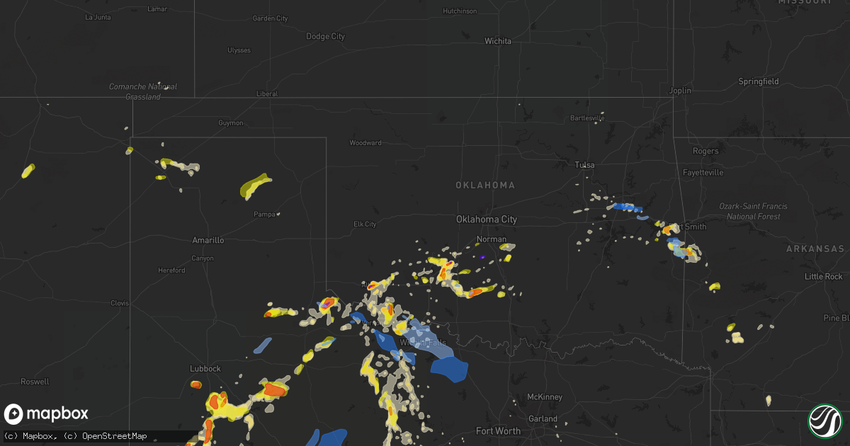
Hail Map in Oklahoma on May 15, 2020
Get this storm
May 15 map
$229
one time, instant access
Download today. No call, no setup
Keep the $229
Bought the map and want the full workflow? Apply the entire $229 to a subscription within 7 days. None of it is wasted.
Every map, not just this one
This buys you this map. Subscription and you get every map we run, in the markets you choose from a few cities to whole states to nationwide. Plus real-time alerts the moment a storm fires.
Contact data
Name, contact info, occupancy, even credit band for addresses in the footprint. You go from where it hit to who to call.
Become the source they trust
Unlimited branding weather history reports on demand. You already have the documented answer ready for the property owner, and you are the one who showed up with it.
Property data and RoofTrace estimates
Pull up any address you have got, its value and the exact code rules for that jurisdiction, straight from One Click Code. Then RoofTrace estimates the squares, pitch, and roof value, priced the way you price.
Storm reports in Oklahoma
Oklahoma
| Date | Description |
|---|---|
| 05/15/20206:55 PM CDT | A local report indicates 76 MPH wind near 7 NW VELMA |
| 05/15/20206:51 PM CDT | A local report indicates 1.00 inch wind near FREDERICK |
| 05/15/20206:50 PM CDT | House tin roof removed by winds. Time estimated by radar. |
| 05/15/20206:50 PM CDT | A local report indicates 66 MPH wind near 7 NW VELMA |
| 05/15/20206:46 PM CDT | On highway 183. |
| 05/15/20206:41 PM CDT | A local report indicates 59 MPH wind near 3 SSE FREDERICK |
| 05/15/20206:37 PM CDT | A local report indicates 1.25 inch wind near S DAVIDSON |
| 05/15/20206:20 PM CDT | Via social media. |
| 05/15/20205:38 PM CDT | A local report indicates 1.00 inch wind near 4 NW APACHE |
| 05/15/20205:37 PM CDT | Mping |
| 05/15/20205:36 PM CDT | A local report indicates 1.25 inch wind near ALTUS |
| 05/15/20205:24 PM CDT | A local report indicates 1.00 inch wind near 2 S ALTUS |
| 05/15/20205:23 PM CDT | On highway 283. |
| 05/15/20205:21 PM CDT | On highway 283. |
| 05/15/20205:08 PM CDT | A local report indicates 1.00 inch wind near DUNCAN |
| 05/15/20205:07 PM CDT | A local report indicates 1.50 inch wind near 7 NNW VELMA |
| 05/15/20204:56 PM CDT | A local report indicates 1.00 inch wind near MARLOW |
| 05/15/20204:55 PM CDT | A local report indicates 58 MPH wind near 2 SSW DUNCAN |
| 05/15/20204:55 PM CDT | Trees down in area of 11th and choctaw. Several power outages. |
| 05/15/20203:28 PM CDT | On highway 180. |
| 05/15/20203:25 PM CDT | A local report indicates 1.50 inch wind near 4 SE CYRIL |
| 05/15/20203:20 PM CDT | Location estimated from radar. |
| 05/15/20203:12 PM CDT | Mping |
| 05/15/20203:08 PM CDT | A local report indicates 2.00 inch wind near 4 SE CEMENT |
| 05/15/20203:07 PM CDT | Gust front |
| 05/15/20203:02 PM CDT | A local report indicates 1.25 inch wind near 4 ESE MEDICINE PARK |
| 05/15/20203:02 PM CDT | Corrected report. Location estimated from radar. |
| 05/15/20202:17 PM CDT | Via social media |
| 05/15/20201:50 PM CDT | Five very large trees blown down damaging a home at the intersection of ross and south cherokee streets |
| 05/15/20201:46 PM CDT | Roofs off barns... Power lines down... Large electrical tower down |
| 05/15/20201:46 PM CDT | Roof partially blown off house |
| 05/15/20201:03 PM CDT | Report of a tree down blocking roadway in checotah. |
| 05/15/202010:30 AM CDT | A local report indicates 59 MPH wind near 1 S WEBBERS FALLS |
| 05/15/20209:55 AM CDT | Usace reported trees down in the spaniard creek area northeast of warner. |
| 05/15/20209:44 AM CDT | A tornado rolled and destroyed a mobile home... Damaged about 15 other homes... Destoyed outbuildings... Uprooted numerous trees... And snapped numerous power poles. Th |
| 05/15/20209:21 AM CDT | Report of power lines and tree limbs down along elm grove road north of keefton and east of highway 64. |
| 05/15/20209:17 AM CDT | Report of trees damaged... Also structural damage to a barn and roof damage. |
| 05/15/20207:41 AM CDT | At 1241 PM CDT, a severe thunderstorm was located near Etowah, moving east at 20 mph. HAZARD...60 mph wind gusts and quarter size hail. SOURCE...Radar indicated. IMPACT...Hail damage to vehicles is expected. Expect wind damage to roofs, siding, and trees. Locations impacted include... Slaughterville, Lexington, Tribbey, St. Louis, Etowah, Brooksville, Macomb, Harjo and Trousdale. |
| 05/15/20207:07 AM CDT | At 1207 AM CDT, a severe thunderstorm was located near Isabella, moving east at 25 mph. HAZARD...Tennis ball size hail and 60 mph wind gusts. SOURCE...Radar indicated. IMPACT...People and animals outdoors will be injured. Expect hail damage to roofs, siding, windows, and vehicles. Expect wind damage to roofs, siding, and trees. Locations impacted include... Enid, Fairview, Waukomis, Lahoma, Ringwood, Drummond, Cleo Springs, Ames, Meno, Orienta and Isabella. |
| 05/15/20203:25 AM CDT | At 824 PM CDT, severe thunderstorms were located along a line extending from 5 miles northeast of Loveland to near Iowa Park to 3 miles northeast of Lake Kickapoo to 6 miles south of Megargel, moving east at 30 mph. HAZARD...Golf ball size hail and 70 mph wind gusts. SOURCE...Trained weather spotters. IMPACT...People and animals outdoors will be injured. Expect hail damage to roofs, siding, windows, and vehicles. Expect considerable tree damage. Wind damage is also likely to mobile homes, roofs, and outbuildings. Locations impacted include... Wichita Falls, Burkburnett, Henrietta, Archer City, Iowa Park, Holliday, Grandfield, Temple, Petrolia, Scotland, Byers, Dean, Randlett, Windthorst, Megargel, Jolly, Devol, Bluegrove, Mankins and Cookietown. |
| 05/15/20202:58 AM CDT | At 758 PM CDT, severe thunderstorms were located along a line extending from 3 miles northwest of Hollister to near Electra to near Lake Diversion to 3 miles west of Westover, moving southeast at 20 mph. HAZARD...60 mph wind gusts and quarter size hail. SOURCE...Radar indicated. IMPACT...Hail damage to vehicles is expected. Expect wind damage to roofs, siding, and trees. Locations impacted include... Frederick, Iowa Park, Electra, Holliday, Grandfield, Davidson, Megargel, Hollister, Loveland, Lake Diversion, Dundee, Westover, Harrold, Mabelle, Mankins, Lake Kickapoo, Oklaunion, eastern Lake Kemp, Pleasant Valley and Haynesville. |
| 05/15/20202:36 AM CDT | At 736 PM CDT, a severe thunderstorm was located 4 miles southwest of Foster, moving east at 15 mph. HAZARD...Ping pong ball size hail and 60 mph wind gusts. SOURCE...Radar indicated. IMPACT...People and animals outdoors will be injured. Expect hail damage to roofs, siding, windows, and vehicles. Expect wind damage to roofs, siding, and trees. Locations impacted include... Elmore City, Katie, Foster, Antioch, Hennepin and Pernell. |
| 05/15/20202:35 AM CDT | At 734 PM CDT, severe thunderstorms were located along a line extending from 4 miles east of Clayton to 8 miles southwest of Texline to 6 miles northeast of Hayden, moving east at 10 mph. HAZARD...Ping pong ball size hail and 60 mph wind gusts. SOURCE...Radar indicated. IMPACT...Minor damage to roofs, siding, and trees is possible. People and animals outdoors will be injured. Expect hail damage to roofs, siding, windows, and vehicles. Locations impacted include... Texline, Ware and Felt. |
| 05/15/20201:58 AM CDT | At 657 PM CDT, severe thunderstorms were located along a line extending from near Humphreys to 7 miles southeast of Eldorado to 7 miles northwest of Margaret to 3 miles east of Gilliland, generally moving east at 10 mph. HAZARD...60 mph wind gusts and quarter size hail. SOURCE...Radar indicated. IMPACT...Hail damage to vehicles is expected. Expect wind damage to roofs, siding, and trees. Locations impacted include... Altus, Vernon, Frederick, Quanah, Crowell, Tipton, Chillicothe, Olustee, Eldorado, Davidson, Elmer, Headrick, Margaret, Lockett, Medicine Mound, Fargo, Humphreys, Odell, Thalia and Harrold. |
| 05/15/20201:57 AM CDT | At 656 PM CDT, a severe thunderstorm was located 5 miles northwest of Velma, moving east at 5 mph. HAZARD...Golf ball size hail and 60 mph wind gusts. SOURCE...Radar indicated. IMPACT...People and animals outdoors will be injured. Expect hail damage to roofs, siding, windows, and vehicles. Expect wind damage to roofs, siding, and trees. Locations impacted include... Velma. |
| 05/15/20201:35 AM CDT | At 635 PM CDT, a severe thunderstorm was located 5 miles southeast of Elmer, moving northeast at 25 mph. HAZARD...60 mph wind gusts and quarter size hail. SOURCE...Radar indicated. IMPACT...Hail damage to vehicles is expected. Expect wind damage to roofs, siding, and trees. Locations impacted include... Altus, Snyder, Tipton, Elmer, Headrick, Friendship, Altus Air Force Base, Warren, Fargo, Humphreys, Odell and Hess. |
| 05/15/20201:26 AM CDT | At 626 PM CDT, a severe thunderstorm was located 5 miles northwest of Velma, moving northeast at 10 mph. HAZARD...60 mph wind gusts and quarter size hail. SOURCE...Radar indicated. IMPACT...Hail damage to vehicles is expected. Expect wind damage to roofs, siding, and trees. Locations impacted include... Bray and Velma. |
| 05/15/20201:25 AM CDT | At 625 PM CDT, a severe thunderstorm was located over Meers, moving northeast at 10 mph. HAZARD...60 mph wind gusts and quarter size hail. SOURCE...Radar indicated. IMPACT...Hail damage to vehicles is expected. Expect wind damage to roofs, siding, and trees. Locations impacted include... Elgin, Medicine Park, Meers, Lake Ellsworth, Lake Lawtonka, Fort Sill and Wichita Mountains Wildlife Refuge. |
| 05/15/20201:06 AM CDT | At 605 PM CDT, a severe thunderstorm was located near Cyril, moving east at 20 mph. HAZARD...60 mph wind gusts and quarter size hail. SOURCE...Radar indicated. IMPACT...Hail damage to vehicles is expected. Expect wind damage to roofs, siding, and trees. Locations impacted include... Chickasha, Cyril, Cement, Norge, Ninnekah and Laverty. |
| 05/15/20201:03 AM CDT | At 603 PM CDT, a severe thunderstorm was located 6 miles northwest of Velma, moving northeast at 15 mph. HAZARD...60 mph wind gusts and quarter size hail. SOURCE...Radar indicated. IMPACT...Hail damage to vehicles is expected. Expect wind damage to roofs, siding, and trees. Locations impacted include... Velma. |
| 05/15/202012:57 AM CDT | At 557 PM CDT, a severe thunderstorm was located 4 miles north of Headrick, moving northeast at 10 mph. HAZARD...60 mph wind gusts and quarter size hail. SOURCE...Radar indicated. IMPACT...Hail damage to vehicles is expected. Expect wind damage to roofs, siding, and trees. Locations impacted include... Altus, Snyder, Mountain Park, Roosevelt, Martha, Headrick, Friendship, Cooperton, Altus Air Force Base, Warren, Humphreys and Tom Steed Reservoir. |
| 05/15/202012:56 AM CDT | At 556 PM CDT, a severe thunderstorm was located 4 miles east of Kirkland, moving west at 5 mph. HAZARD...Two inch hail and 70 mph wind gusts. SOURCE...Radar indicated. IMPACT...People and animals outdoors will be injured. Expect hail damage to roofs, siding, windows, and vehicles. Expect considerable tree damage. Wind damage is also likely to mobile homes, roofs, and outbuildings. Locations impacted include... Quanah, Goodlett and Lazare. |
| 05/15/202012:35 AM CDT | At 535 PM CDT, a severe thunderstorm was located 5 miles north of Apache, moving east at 20 mph. HAZARD...60 mph wind gusts and quarter size hail. SOURCE...Radar indicated. IMPACT...Hail damage to vehicles is expected. Expect wind damage to roofs, siding, and trees. Locations impacted include... Anadarko, Apache, Cyril, Cement, Boone and Stecker. |
| 05/15/202012:16 AM CDT | At 516 PM CDT, a severe thunderstorm was located near Altus, moving northeast at 15 mph. HAZARD...Golf ball size hail and 60 mph wind gusts. SOURCE...Radar indicated. IMPACT...People and animals outdoors will be injured. Expect hail damage to roofs, siding, windows, and vehicles. Expect wind damage to roofs, siding, and trees. Locations impacted include... Altus, Headrick, Friendship, Altus Air Force Base, Humphreys and Warren. |
| 05/15/202012:12 AM CDT | At 511 PM CDT, severe thunderstorms were located along a line extending from 5 miles north of Bray to 3 miles east of Duncan, moving east at 10 mph. HAZARD...Ping pong ball size hail and 60 mph wind gusts. SOURCE...Radar indicated. IMPACT...People and animals outdoors will be injured. Expect hail damage to roofs, siding, windows, and vehicles. Expect wind damage to roofs, siding, and trees. Locations impacted include... Duncan, Marlow, Bray, Velma and Cox City. |
| 05/14/202011:59 PM CDT | At 458 PM CDT, a severe thunderstorm was located 7 miles north of Goodlett, moving southeast at 10 mph. Another severe thunderstorm was located 8 miles west northwest of Coppers Breaks State Park moving northeast at 15 mph. HAZARD...60 mph wind gusts and quarter size hail. SOURCE...Radar indicated. IMPACT...Hail damage to vehicles is expected. Expect wind damage to roofs, siding, and trees. Locations impacted include... Quanah, Eldorado and Goodlett. |
| 05/14/202011:43 PM CDT | At 443 PM CDT, severe thunderstorms were located along a line extending from near Rush Springs to near Duncan, moving east at 25 mph. HAZARD...Ping pong ball size hail and 60 mph wind gusts. SOURCE...Radar indicated. IMPACT...People and animals outdoors will be injured. Expect hail damage to roofs, siding, windows, and vehicles. Expect wind damage to roofs, siding, and trees. Locations impacted include... Duncan, Marlow, Rush Springs, Bray and Cox City. |
| 05/14/202011:28 PM CDT | At 428 PM CDT, a severe thunderstorm was located near Hennepin, moving northeast at 15 mph. HAZARD...60 mph wind gusts and quarter size hail. SOURCE...Radar indicated. IMPACT...Hail damage to vehicles is expected. Expect wind damage to roofs, siding, and trees. Locations impacted include... Pauls Valley, Davis, Wynnewood, Katie and Hennepin. |
| 05/14/202011:10 PM CDT | At 410 PM CDT, a severe thunderstorm was located 7 miles west of Marlow, moving east at 20 mph. HAZARD...Ping pong ball size hail and 60 mph wind gusts. SOURCE...Radar indicated. IMPACT...People and animals outdoors will be injured. Expect hail damage to roofs, siding, windows, and vehicles. Expect wind damage to roofs, siding, and trees. Locations impacted include... Duncan, Marlow, Rush Springs, Central High and Acme. |
| 05/14/202010:47 PM CDT | At 346 PM CDT, a severe thunderstorm was located 6 miles southwest of Sterling, moving northeast at 10 mph. HAZARD...Ping pong ball size hail and 60 mph wind gusts. SOURCE...Radar indicated. IMPACT...People and animals outdoors will be injured. Expect hail damage to roofs, siding, windows, and vehicles. Expect wind damage to roofs, siding, and trees. Locations impacted include... Northeastern Lawton, Elgin, Fletcher, Sterling and eastern Fort Sill. |
| 05/14/202010:26 PM CDT | At 326 PM CDT, severe thunderstorms were located along a line extending from near Lake Chickasha to near Cement to near Sterling, moving northeast at 25 mph. HAZARD...Ping pong ball size hail and 60 mph wind gusts. SOURCE...Radar indicated. IMPACT...People and animals outdoors will be injured. Expect hail damage to roofs, siding, windows, and vehicles. Expect wind damage to roofs, siding, and trees. Locations impacted include... Chickasha, Anadarko, Rush Springs, Fletcher, Cyril, Sterling, Verden, Cement, Amber, Pocasset, Norge, Agawam, Lake Chickasha, Ninnekah, Acme and Laverty. |
| 05/14/202010:07 PM CDT | At 306 PM CDT, severe thunderstorms were located along a line extending from 4 miles south of Cement to 7 miles southwest of Sterling, moving north at 15 mph. Half dollar size hail was reported near Elgin. HAZARD...60 mph wind gusts and quarter size hail. SOURCE...Radar indicated. IMPACT...Hail damage to vehicles is expected. Expect wind damage to roofs, siding, and trees. Locations impacted include... Elgin, Fletcher, Cyril, Sterling, Verden, Cement and eastern Fort Sill. |
| 05/14/20209:57 PM CDT | At 257 PM CDT, a severe thunderstorm was located 5 miles east of Cement, moving northeast at 10 mph. HAZARD...60 mph wind gusts and quarter size hail. SOURCE...Radar indicated. IMPACT...Hail damage to vehicles is expected. Expect wind damage to roofs, siding, and trees. Locations impacted include... Chickasha, Verden, Norge, Agawam, Ninnekah and Laverty. |
| 05/14/20208:40 PM CDT | At 139 PM CDT, a severe thunderstorm was located near Wayne, moving northeast at 10 mph. HAZARD...60 mph wind gusts and quarter size hail. SOURCE...Radar indicated. IMPACT...Hail damage to vehicles is expected. Expect wind damage to roofs, siding, and trees. Locations impacted include... Purcell, Lexington and Wayne. |
| 05/14/20208:13 PM CDT | At 113 PM CDT, a severe thunderstorm was located near Rosedale, moving east at 10 mph. HAZARD...60 mph wind gusts and quarter size hail. SOURCE...Radar indicated. IMPACT...Hail damage to vehicles is expected. Expect wind damage to roofs, siding, and trees. Locations impacted include... Wayne, Wanette, Byars and Rosedale. |
| 05/14/20207:35 PM CDT | Via mping |
| 05/14/20207:32 PM CDT | A brief tornado was observed by a storm chaser. |
| 05/14/20207:15 PM CDT | On highway 183. |
All States Impacted by Hail Map on May 15, 2020
Cities Impacted by Hail Map on May 15, 2020
- Ellsworth, NE
- Anadarko, OK
- Big Spring, TX
- Santa Anna, TX
- Santa Fe, TX
- Dickinson, TX
- Paducah, TX
- Sterling City, TX
- Midland, TX
- Tahoka, TX
- Lawton, OK
- Wichita Falls, TX
- Batesville, TX
- Electra, TX
- Bluff Dale, TX
- Stephenville, TX
- Andrews, TX
- Muskogee, OK
- Longton, KS
- Clayton, NM
- Crystal City, TX
- Throckmorton, TX
- Seymour, TX
- Poteau, OK
- Hartford, AR
- Cameron, OK
- Garden City, TX
- Mason, TX
- Comfort, TX
- Goldsmith, TX
- Odessa, TX
- Breckenridge, TX
- Comanche, TX
- Taft, TX
- Davis, OK
- Hennepin, OK
- Elmore City, OK
- Poteet, TX
- Charlotte, TX
- Bigfoot, TX
- Wilson, TX
- Hebbronville, TX
- Realitos, TX
- Armstrong, TX
- Linn, TX
- Fort Sill, OK
- Sonora, TX
- Snyder, TX
- Lamesa, TX
- Ramah, CO
- Simla, CO
- Calhan, CO
- Eads, CO
- Haswell, CO
- Caddo, TX
- Ranger, TX
- Gans, OK
- Muldrow, OK
- Keota, OK
- Spiro, OK
- Ackerly, TX
- Center Point, TX
- Kerrville, TX
- Medina, TX
- Bandera, TX
- Falls City, TX
- Hobson, TX
- Karnes City, TX
- Moran, TX
- Cisco, TX
- Sallisaw, OK
- Dublin, TX
- De Leon, TX
- Dalhart, TX
- Graham, TX
- Altus, OK
- Gore, OK
- Mountain View, OK
- Floresville, TX
- Fredericksburg, TX
- Mena, AR
- Turkey, TX
- Loving, TX
- Olney, TX
- Uvalde, TX
- Knippa, TX
- Lampasas, TX
- San Saba, TX
- Childress, TX
- Weatherford, TX
- Leesville, TX
- Nixon, TX
- Bay City, TX
- Palacios, TX
- Elmaton, TX
- Crowell, TX
- Wagon Mound, NM
- Seminole, TX
- Kenedy, TX
- Bishop, TX
- Altus Afb, OK
- Headrick, OK
- Mountain Park, OK
- Snyder, OK
- Tipton, OK
- Hyannis, NE
- Yuma, CO
- Matador, TX
- La Pryor, TX
- Mertzon, TX
- Blanco, TX
- Hye, TX
- Johnson City, TX
- Roosevelt, OK
- Murfreesboro, AR
- Nashville, AR
- Wanette, OK
- Lexington, OK
- Pipe Creek, TX
- Fluvanna, TX
- Mullen, NE
- Hico, TX
- Hondo, TX
- Strykersville, NY
- Varysburg, NY
- Foster, OK
- Delight, AR
- Lometa, TX
- Goldthwaite, TX
- Stanton, TX
- Oshkosh, NE
- Ashby, NE
- Lamar, OK
- Dustin, OK
- Mingus, TX
- San Antonio, TX
- Encino, TX
- Elmer, OK
- Cyril, OK
- Fletcher, OK
- Ninnekah, OK
- Apache, OK
- Chickasha, OK
- Elgin, OK
- Marlow, OK
- Rush Springs, OK
- Cement, OK
- Chillicothe, TX
- Flomot, TX
- Girard, TX
- Marathon, TX
- Woodson, TX
- Lakeside, NE
- Boerne, TX
- Davidson, OK
- Odonnell, TX
- Kendalia, TX
- Canyon Lake, TX
- Spring Branch, TX
- Robstown, TX
- Keenesburg, CO
- Akron, CO
- Cotulla, TX
- Encinal, TX
- Laredo, TX
- Del Valle, TX
- Duncan, OK
- Holliday, TX
- Rising Star, TX
- Quanah, TX
- Okolona, AR
- Arkadelphia, AR
- Sweetwater, TX
- Blackwell, TX
- New Braunfels, TX
- Cherokee, TX
- Tow, TX
- Llano, TX
- Vernon, TX
- Channing, TX
- Comstock, TX
- Carnegie, OK
- Sweeny, TX
- Jourdanton, TX
- Campo, CO
- Loveland, OK
- Grandfield, OK
- Frederick, OK
- Bend, TX
- Sandia, TX
- Matagorda, TX
- Brady, TX
- Pottsville, TX
- Galveston, TX
- Kingsville, TX
- Edinburg, TX
- Concan, TX
- Corpus Christi, TX
- Big Lake, TX
- Cuero, TX
- Yoakum, TX
- Pampa, TX
- Miami, TX
- Pearsall, TX
- Moore, TX
- Hallettsville, TX
- Tarzan, TX
- Sidney, NE
- Flagler, CO
- Seibert, CO
- Gorman, TX
- Jacksonville, TX
- Guerra, TX
- Carlsbad, TX
- Del Rio, TX
- Hudson, CO
- Roggen, CO
- Edna, TX
- Freer, TX
- Tilden, TX
- Rocksprings, TX
- Stockdale, TX
- Zapata, TX
- Garciasville, TX
- Gardendale, TX
- Sabinal, TX
- Owanka, SD
- Stratford, TX
- Sulphur, OK
- Tyler, TX
- Lindale, TX
- Rockdale, TX
- Iowa Park, TX
- Burkburnett, TX
- Huntington, AR
- Booneville, AR
- Mansfield, AR
- Greenwood, AR
- Austin, TX
- Midland, AR
- Hackett, AR
- Utopia, TX
- Bokoshe, OK
- Shady Point, OK
- East Concord, NY
- Holland, NY
- Chaffee, NY
- Cross Plains, TX
- Justiceburg, TX
- Cedar Creek, TX
- Wynnewood, OK
- Horseshoe Bay, TX
- Kingsland, TX
- Gail, TX
- Post, TX
- Coahoma, TX
- San Angelo, TX
- Orange Grove, TX
- Alice, TX
- Boulder, CO
- Lafayette, CO
- Longmont, CO
- Erie, CO
- Robert Lee, TX
- Three Rivers, TX
- Campbellton, TX
- Brackettville, TX
- Strawn, TX
- Graford, TX
- Elgin, TX
- Whitsett, TX
- Glenwood, NY
- Braggs, OK
- Eldorado, TX
- Limon, CO
- Matheson, CO
- McCaskill, AR
- Barnhart, TX
- Bangs, TX
- Mounds, OK
- Sapulpa, OK
- Eufaula, OK
- Rio Grande City, TX
- Amber, OK
- Blanchard, OK
- Blevins, AR
- Lenorah, TX
- Castroville, TX
- Newcastle, TX
- Dryden, TX
- Harrold, TX
- Oklaunion, TX
- Southlake, TX
- Leakey, TX
- Ganado, TX
- North Java, NY
- Bliss, NY
- Frederick, CO
- Firestone, CO
- Meadow, TX
- Plain Dealing, LA
- Emerson, AR
- Pleasanton, TX
- Runge, TX
- Yorktown, TX
- Ecleto, TX
- Gillett, TX
- Mirando City, TX
- Whitman, NE
- Quinton, OK
- Stigler, OK
- Alex, OK
- Gustine, TX
- Cache, OK
- Indiahoma, OK
- Chattanooga, OK
- Morris, OK
- Okmulgee, OK
- Haskell, OK
- Odell, TX
- Olustee, OK
- Eldorado, OK
- Hollister, OK
- Colorado City, TX
- Gonzales, TX
- Fort Lupton, CO
- Kirk, CO
- Burlington, CO
- Idalia, CO
- Kanorado, KS
- Wallis, TX
- Magnolia, AR
- Severy, KS
- Piedmont, KS
- Maysville, OK
- Wayne, OK
- Purcell, OK
- Santo, TX
- Von Ormy, TX
- Somerset, TX
- Gainesville, NY
- Eastland, TX
- Westbrook, TX
- Jayton, TX
- D Hanis, TX
- Randlett, OK
- Cost, TX
- Dayton, TX
- Stanley, NY
- Sidney, TX
- Carbon, TX
- Mullin, TX
- Council Hill, OK
- Noble, OK
- Concepcion, TX
- Kemp, TX
- Yancey, TX
- Bartlesville, OK
- Mission, TX
- Cedar Park, TX
- Alvin, TX
- Liverpool, TX
- Dacono, CO
- Delaware, OK
- Hamilton, TX
- Buchanan Dam, TX
- Bluffton, TX
- Wrightsboro, TX
- Hugo, CO
- Quemado, TX
- Eagle Pass, TX
- Vona, CO
- League City, TX
- Texas City, TX
- Port Lavaca, TX
- Manor, TX
- Desdemona, TX
- Evant, TX
- Asherton, TX
- El Dorado, KS
- Leon, KS
- Raton, NM
- Falfurrias, TX
- Round Mountain, TX
- Ira, TX
- Ballinger, TX
- Coleman, TX
- Iredell, TX
- Boynton, OK
- Oktaha, OK
- Kaufman, TX
- Terrell, TX
- Seadrift, TX
- Walters, OK
- Sheppard Afb, TX
- Cherryvale, KS
- Dubberly, LA
- Macomb, OK
- Meridian, TX
- Cranfills Gap, TX
- Clifton, TX
- Jonesboro, TX
- Rio Frio, TX
- Mathis, TX
- Calliham, TX
- Lindsay, OK
- Carrizo Springs, TX
- Crosbyton, TX
- Seguin, TX
- Woodrow, CO
- Waldron, AR
- Mcalester, OK
- Ozona, TX
- Baird, TX
- Roland, OK
- Burnet, TX
- Rusk, TX
- Hunt, TX
- Nordheim, TX
- Wolfforth, TX
- Willow City, TX
- Ralls, TX
- Dumas, TX
- Karval, CO
- Royse City, TX
- Atascosa, TX
- Newkirk, OK
- Haynesville, LA
- Grulla, TX
- Warner, OK
- Bastrop, TX
- Palo Pinto, TX
- Rowena, TX
- Taft, OK
- Oden, AR
- Byers, TX
- Lewisville, TX
- Premont, TX
- Arcade, NY
- Benton, LA
- Lipan, TX
- Devine, TX
- Archer City, TX
- Cedar Vale, KS
- Grenola, KS
- Loraine, TX
- Cameron, TX
- Buckholts, TX
- Smiley, TX
- Lindon, CO
- Cope, CO
- Goliad, TX
- Mineral Wells, TX
- Bradley, OK
- Temple, OK
- Forney, TX
- New Underwood, SD
- Winchester, NH
- Maryneal, TX
- Beeville, TX
- Howard, KS
- Hanna, OK
- Peyton, CO
- Spur, TX
- Stinnett, TX
- Van Vleck, TX
- Mccurtain, OK
- Marion, TX
- Tulsa, OK
- Ozan, AR
- Whitefield, OK
- Gotebo, OK
- George West, TX
- Henryetta, OK
- Crandall, TX
- Deer Trail, CO
- Denton, TX
- Sinton, TX
- Pocola, OK
- Heavener, OK
- Jacksboro, TX
- Aransas Pass, TX
- Rockport, TX
- Texline, TX
- Carlton, TX
- Barksdale, TX
- Portland, TX
- Houston, TX
- Nowata, OK
- Mineola, TX
- Victoria, TX
- Jenks, OK
- Kingsbury, TX
- Hobart, OK
- Fort Cobb, OK
- Geronimo, OK
- Woodsboro, TX
- Howe, OK
- Alpine, TX
- Crane, TX
- Monahans, TX
- Luling, TX
- Java Center, NY
- Mcadoo, TX
- Roaring Springs, TX
- Roscoe, TX
- Lohn, TX
- Miles, TX
- Paint Rock, TX
- Eola, TX
- Vancourt, TX
- Gouldbusk, TX
- Doole, TX
- Millersview, TX
- Voss, TX
- Wall, TX
- Eden, TX
- Christoval, TX
- Mereta, TX
- Zephyr, TX
- Valera, TX
- Brownwood, TX
- Blanket, TX
- May, TX
- Early, TX
- Brookesmith, TX
- Talpa, TX
- Dilley, TX
- Laughlin Afb, TX
- Big Wells, TX
- Trent, TX
- McCaulley, TX
- Hamlin, TX
- Merkel, TX
- Sylvester, TX
- Hawley, TX
- Abilene, TX
- Anson, TX
- Dyess Afb, TX
- Nolan, TX
- Tye, TX
- Henrietta, TX
- Petrolia, TX
- Ringgold, TX
- Bellevue, TX
- Devol, OK
- Windthorst, TX
- Bowie, TX
- Sunset, TX
- Chico, TX
- Gordon, TX
- Tarpley, TX
- Bulverde, TX
- Stonewall, TX
- Bergheim, TX
- Bertram, TX
- Catarina, TX
- Tolar, TX
- Granbury, TX
- Shiner, TX
- Cleburne, TX
- Skidmore, TX
- San Diego, TX
- El Campo, TX
- Garwood, TX
- Damon, TX
- Guy, TX
- Glen Flora, TX
- Needville, TX
- Louise, TX
- Boling, TX
- Wharton, TX
- Sugar Land, TX
- Rosenberg, TX
- Richmond, TX
- Eagle Lake, TX
- Alleyton, TX
- Fulshear, TX
- Columbus, TX
- Sealy, TX
- East Bernard, TX
- Manvel, TX
- Stafford, TX
- Rosharon, TX
- Missouri City, TX
- Pearland, TX
- Fresno, TX
- Vian, OK
- Webbers Falls, OK
- Medicine Park, OK
- Dalton, NY
- Canaseraga, NY
- Cohocton, NY
- Hunt, NY
- Dansville, NY
- Nunda, NY
- Wayland, NY
- Swain, NY
- Portageville, NY
- Romulus, NY
- Prattsburgh, NY
- Keuka Park, NY
- Naples, NY
- Conesus, NY
- Scottsburg, NY
- Branchport, NY
- Dresden, NY
- Lodi, NY
- Ovid, NY
- Springwater, NY
- Penn Yan, NY
- Groveland, NY
- Interlaken, NY
- Middlesex, NY
- Himrod, NY
- Rushville, NY
- Honeoye, NY
- North Rose, NY
- Wolcott, NY
- Geneva, NY
- Cayuga, NY
- Scipio Center, NY
- Aurora, NY
- Seneca Falls, NY
- Waterloo, NY
- Union Springs, NY
- Fayette, NY
- Newport, NY
- Poland, NY
- Remsen, NY
- Little Falls, NY
- Salisbury Center, NY
- Barneveld, NY
- Caroga Lake, NY
- Holland Patent, NY
- Stratford, NY
- Hoffmeister, NY
- Prospect, NY
- Cold Brook, NY
- Oriskany, NY
- Rome, NY
- Marcy, NY
- Johnstown, NY
- Dolgeville, NY
- Middleville, NY
- Utica, NY
- Whitesboro, NY
- Saint Johnsville, NY
- Gloversville, NY
- Owego, NY
- Newark Valley, NY
- Endicott, NY
- Candor, NY
- Grand Gorge, NY
- Windham, NY
- Nineveh, NY
- Stamford, NY
- Delancey, NY
- Hancock, NY
- Gilboa, NY
- Denver, NY
- Roxbury, NY
- Afton, NY
- Deposit, NY
- Sidney Center, NY
- Windsor, NY
- Hobart, NY
- Harpursville, NY
- Masonville, NY
- Sidney, NY
- Bloomville, NY
- Franklin, NY
- Halcottsville, NY
- Margaretville, NY
- New Kingston, NY
- Ouaquaga, NY
- Ashland, NY
- Unadilla, NY
- Bainbridge, NY
- Delhi, NY
- Bovina Center, NY
- Andes, NY
- Hamden, NY
- Walton, NY
- East Branch, NY
- South Kortright, NY
- Downsville, NY
- Prattsville, NY
- Voorheesville, NY
- Hinsdale, MA
- New Lisbon, NY
- Worcester, NY
- East Berne, NY
- Hartwick, NY
- Chesterfield, MA
- Stephentown, NY
- West Burlington, NY
- Berne, NY
- New Lebanon, NY
- Canaan, NY
- Ravena, NY
- Schoharie, NY
- Howes Cave, NY
- Dalton, MA
- Burlington Flats, NY
- Clarksville, NY
- Northampton, MA
- Sharon Springs, NY
- Westerlo, NY
- Leeds, MA
- Westford, NY
- Becket, MA
- Chester, MA
- Selkirk, NY
- Warren, MA
- West Oneonta, NY
- East Chatham, NY
- Fly Creek, NY
- Florence, MA
- Oneonta, NY
- East Meredith, NY
- Warnerville, NY
- Worthington, MA
- Middlefield, MA
- Otego, NY
- Middleburgh, NY
- Edmeston, NY
- Richmondville, NY
- Ware, MA
- Brainard, NY
- Mount Vision, NY
- Davenport, NY
- West Chesterfield, MA
- Fultonham, NY
- Davenport Center, NY
- Norwich, NY
- Belchertown, MA
- Feura Bush, NY
- New Berlin, NY
- Delmar, NY
- Milford, NY
- Hadley, MA
- Southampton, MA
- Lenox, MA
- Maryland, NY
- Sherburne, NY
- Richfield Springs, NY
- West Davenport, NY
- East Nassau, NY
- Laurens, NY
- Nassau, NY
- South Bethlehem, NY
- Pittsfield, MA
- Garrattsville, NY
- Old Chatham, NY
- Springfield Center, NY
- Cherry Valley, NY
- South New Berlin, NY
- Coeymans Hollow, NY
- Glenmont, NY
- Roseboom, NY
- Schodack Landing, NY
- Easthampton, MA
- Castleton On Hudson, NY
- Cobleskill, NY
- Schenevus, NY
- Granby, MA
- Delanson, NY
- Charlotteville, NY
- Portlandville, NY
- Jefferson, NY
- Central Bridge, NY
- Summit, NY
- East Worcester, NY
- Huntington, MA
- South Hadley, MA
- Morris, NY
- Holyoke, MA
- Cooperstown, NY
- New Boston, NH
- Dunbarton, NH
- Antrim, NH
- Shushan, NY
- Wardsboro, VT
- Manchester, VT
- Schuylerville, NY
- Saratoga Springs, NY
- Goffstown, NH
- Stoddard, NH
- Hancock, NH
- Keene, NH
- Greenwich, NY
- Westmoreland, NH
- Bondville, VT
- Alstead, NH
- Eagle Bridge, NY
- Manchester Center, VT
- Walpole, NH
- Hooksett, NH
- Weare, NH
- Greenfield, NH
- Gilsum, NH
- Gansevoort, NY
- Arlington, VT
- Putney, VT
- Marlborough, NH
- North Bennington, VT
- Victory Mills, NY
- Stillwater, NY
- Cambridge, NY
- Newfane, VT
- Sullivan, NH
- Townshend, VT
- Jamaica, VT
- Bennington, NH
- Chester, VT
- Greenfield Center, NY
- Nelson, NH
- Westminster, VT
- Harrisville, NH
- Shaftsbury, VT
- Hillsborough, NH
- East Arlington, VT
- Francestown, NH
- Salem, NY
- Manchester, NH
- West Townshend, VT
- West Wardsboro, VT
- South Deerfield, MA
- Shutesbury, MA
- Palatine Bridge, NY
- North Hatfield, MA
- West Sand Lake, NY
- Guilderland, NY
- North Brookfield, MA
- Amherst, MA
- Wynantskill, NY
- New Braintree, MA
- East Schodack, NY
- Fonda, NY
- Sunderland, MA
- Haydenville, MA
- Petersburg, NY
- Gilbertville, MA
- Troy, NY
- Leicester, MA
- Williamsburg, MA
- Latham, NY
- East Greenbush, NY
- Rensselaer, NY
- Slingerlands, NY
- Sloansville, NY
- Amsterdam, NY
- Fort Plain, NY
- Berkshire, MA
- Hatfield, MA
- Averill Park, NY
- Sand Lake, NY
- Cummington, MA
- Schenectady, NY
- Altamont, NY
- Poestenkill, NY
- Spencer, MA
- Esperance, NY
- Paxton, MA
- Shelburne Falls, MA
- Hardwick, MA
- Carlisle, NY
- Ashfield, MA
- Conway, MA
- Goshen, MA
- Sprakers, NY
- Pattersonville, NY
- Cheshire, MA
- Oakham, MA
- Windsor, MA
- Fultonville, NY
- Jordanville, NY
- Rutland, MA
- Plainfield, MA
- Worcester, MA
- Savoy, MA
- Canajoharie, NY
- Van Hornesville, NY
- South Barre, MA
- Watervliet, NY
- Duanesburg, NY
- Williamstown, MA
- Albany, NY
- West Hatfield, MA
- Lanesborough, MA
- Barre, MA
- Charlemont, MA
- Leverett, MA
- Brookline, NH
- Readsboro, VT
- West Chesterfield, NH
- Pepperell, MA
- Ashby, MA
- Ashburnham, MA
- Jacksonville, VT
- Chesterfield, NH
- Bernardston, MA
- Wilton, NH
- Greenville, NH
- Whitingham, VT
- West Townsend, MA
- Stamford, VT
- Royalston, MA
- Fitchburg, MA
- Brattleboro, VT
- West Halifax, VT
- Northfield, MA
- Gill, MA
- Ashuelot, NH
- Shirley, MA
- Swanzey, NH
- Hoosick Falls, NY
- Jaffrey, NH
- Warwick, MA
- Troy, NH
- Lunenburg, MA
- Peterborough, NH
- Wilmington, VT
- Fitzwilliam, NH
- Rindge, NH
- New Ipswich, NH
- Bennington, VT
- Winchendon, MA
- Milford, NH
- Townsend, MA
- Hinsdale, NH
- Temple, NH
- Vernon, VT
- Pownal, VT
- Groton, MA
- Dunstable, MA
- Hannacroix, NY
- Austerlitz, NY
- Stuyvesant, NY
- Spencertown, NY
- Westfield, MA
- Ghent, NY
- West Stockbridge, MA
- Stockbridge, MA
- South Lee, MA
- Lenox Dale, MA
- Blandford, MA
- Chatham, NY
- West Coxsackie, NY
- Tyringham, MA
- Valatie, NY
- Kinderhook, NY
- Richmond, MA
- Russell, MA
- Housatonic, MA
- Otis, MA
- Lee, MA


