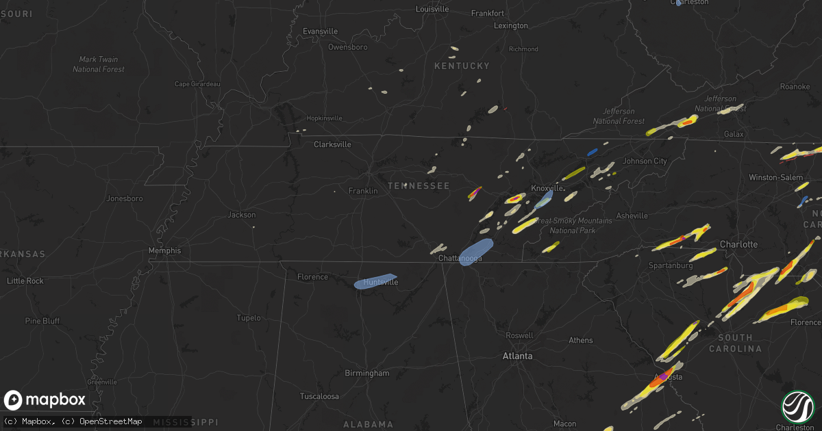
Hail Map in Tennessee on May 6, 2022
Get this storm
May 6 map
$229
one time, instant access
Download today. No call, no setup
Keep the $229
Bought the map and want the full workflow? Apply the entire $229 to a subscription within 7 days. None of it is wasted.
Every map, not just this one
This buys you this map. Subscription and you get every map we run, in the markets you choose from a few cities to whole states to nationwide. Plus real-time alerts the moment a storm fires.
Contact data
Name, contact info, occupancy, even credit band for addresses in the footprint. You go from where it hit to who to call.
Become the source they trust
Unlimited branding weather history reports on demand. You already have the documented answer ready for the property owner, and you are the one who showed up with it.
Property data and RoofTrace estimates
Pull up any address you have got, its value and the exact code rules for that jurisdiction, straight from One Click Code. Then RoofTrace estimates the squares, pitch, and roof value, priced the way you price.
Storm reports in Tennessee
Tennessee
| Date | Description |
|---|---|
| 05/06/20226:00 PM CDT | Some trees and power lines down. |
| 05/06/20225:25 PM CDT | Trees and power lines down across the entire county. |
| 05/06/20225:12 PM CDT | Two trees blown down and 58 mph wind gust recorded on home weather station. |
| 05/06/20225:12 PM CDT | Quarter size hail reported. |
| 05/06/20225:08 PM CDT | Trees and power lines down several locations across the county. |
| 05/06/20225:04 PM CDT | Several trees and power lines down. |
| 05/06/20224:42 PM CDT | Quarter size hail reported 1 mile south of greenville. |
| 05/06/20224:10 PM CDT | A local report indicates 1.25 inch wind near 3 SE BLOOMINGDALE |
| 05/06/20224:05 PM CDT | Trees and power lines down. |
| 05/06/20224:05 PM CDT | Trees and power lines down. |
| 05/06/20224:05 PM CDT | Trees and power lines down. |
| 05/06/20224:05 PM CDT | A local report indicates 1.00 inch wind near CHESTNUT HILL |
| 05/06/20223:48 PM CDT | A local report indicates 1.25 inch wind near 3 NNW GREENEVILLE |
| 05/06/20223:31 PM CDT | Asos station ktys knoxville mcghee tyson. |
| 05/06/20223:30 PM CDT | Trees and power lines down between pigeon forge and sevierville. |
| 05/06/20223:25 PM CDT | Multiple reports of trees and power lines down west of knoxville. |
| 05/06/20223:25 PM CDT | Multiple trees and power lines down in and around the city of maryville. |
| 05/06/20223:20 PM CDT | A local report indicates 1.25 inch wind near 1 NE MOSHEIM |
| 05/06/20223:20 PM CDT | A few trees down. |
| 05/06/20223:10 PM CDT | Trees down. Browder hollow rd and loudon ridge rd and 1.25 mil south of loudon ridge rd/ old hwy 95.harrison rd. |
| 05/06/20223:10 PM CDT | Trees down. Shed destroyed. |
| 05/06/20222:53 PM CDT | Asos station kcha chattanooga airport. |
| 05/06/20222:50 PM CDT | Corrects previous hail report from 1 wnw tariffville. Several trees down. |
| 05/06/20222:50 PM CDT | Trees down. |
| 05/06/20222:50 PM CDT | A local report indicates 1.00 inch wind near HILLSVIEW |
| 05/06/20222:45 PM CDT | Reports of trees and power lines down across the city. |
| 05/06/20222:33 PM CDT | Tree down on vehicle east 8th street near douglas street. |
| 05/06/20222:30 PM CDT | A local report indicates 1.25 inch wind near 2 W TALBOTT |
| 05/06/20222:30 PM CDT | Corrects previous hail report from 1 nnw pioneer. Trees and power lines down. |
| 05/06/20222:27 PM CDT | Large tree down at hwy 70 and bethlehem road. |
| 05/06/20222:20 PM CDT | Large tree branch down near andrew jackson elementary school. |
| 05/06/20222:10 PM CDT | Large tree branch on power line causing power outage. |
| 05/06/20222:10 PM CDT | Trees down. |
| 05/06/20222:00 PM CDT | 5 inch dia / 25 feet tree down along i-40. |
| 05/06/20221:50 PM CDT | Recorded on home weather station. |
| 05/06/20221:50 PM CDT | A local report indicates 1.00 inch wind near TREADWAY |
| 05/06/20221:50 PM CDT | Several trees down. |
| 05/06/20221:42 PM CDT | Large tree down in victor ashe park. |
| 05/06/20221:30 PM CDT | Several trees down. |
| 05/06/20221:30 PM CDT | Trees and power lines down. |
| 05/06/20221:23 PM CDT | Twitter report and photos showed hen egg size hail near crossville. |
| 05/06/20221:17 PM CDT | Trees and power lines down across the county. |
| 05/06/20221:15 PM CDT | Few trees down. |
| 05/06/20221:14 PM CDT | A few trees down. |
| 05/06/20221:10 PM CDT | Few trees down. |
| 05/06/20221:10 PM CDT | Lake tansi. |
| 05/06/202212:30 PM CDT | Large tree down. |
| 05/06/202212:30 PM CDT | A local report indicates 1.00 inch wind near MARYVILLE |
| 05/06/202212:25 PM CDT | Beverley road/anderson road in n. Knoxville... Tree down... 3 diameter total... Multi trunk... Beverly road partially blocked. |
| 05/06/20227:52 AM CDT | At 1252 PM CDT, a severe thunderstorm was located near Kimball, or 7 miles northwest of Jasper, moving northeast at 35 mph. HAZARD...60 mph wind gusts and quarter size hail. SOURCE...Radar indicated. IMPACT...Hail damage to vehicles is expected. Expect wind damage to roofs, siding, and trees. Locations impacted include... Dunlap, Jasper, Signal Mountain, Whitwell, Fairmount, Powells Crossroads, Martin Springs, Cartwright, Fiery Gizzard State Park and Griffith Creek. |
| 05/06/20221:14 AM CDT | At 613 PM EDT, severe thunderstorms were located along a line extending from near Jonesville to 8 miles southwest of Gate City to Gray, moving northeast at 45 mph. This line of storm has a history of producing damaging winds. HAZARD...60 mph wind gusts and quarter size hail. SOURCE...Radar indicated. IMPACT...Hail damage to vehicles is expected. Expect wind damage to roofs, siding, and trees. Locations impacted include... Kingsport, Bristol Tn, Bristol Va, Abingdon, Norton, Lebanon, Wise, Gate City, Big Stone Gap and Weber City.This includes the following highways... Interstate 26 in Tennessee between mile markers 1 and 5. Interstate 81 in Tennessee between mile markers 58 and 75. Interstate 81 in Virginia between mile markers 1 and 24. |
| 05/06/20221:06 AM CDT | At 605 PM EDT, a severe thunderstorm was located 6 miles northwest of Burnsville, moving east at 45 mph. HAZARD...60 mph wind gusts and penny size hail. SOURCE...Radar indicated. IMPACT...Expect damage to trees and power lines. Locations impacted include... Spruce Pine, Burnsville, Newland, Banner Elk, Elk Park, Bakersville, Beech Mountain In Avery County, Crossnore, Sugar Mountain and Linville Falls. |
| 05/05/202211:47 PM CDT | At 446 PM EDT, a severe thunderstorm was located near Sevierville, moving northeast at 40 mph. HAZARD...Ping pong ball size hail and 60 mph wind gusts. SOURCE...Radar indicated. IMPACT...People and animals outdoors will be injured. Expect hail damage to roofs, siding, windows, and vehicles. Expect wind damage to roofs, siding, and trees. Locations impacted include... Sevierville, Newport, Gatlinburg, Dandridge, Pigeon Forge, White Pine, Baneberry, Parrottsville, Smoky Mountains-Big Creek and Pittman Center.This includes Interstate 40 in Tennessee between mile markers 423 and451. |
| 05/05/202211:31 PM CDT | At 431 PM EDT, a severe thunderstorm was located 8 miles north of Walnut Hill, or 8 miles northwest of Bristol Va, moving northeast at 35 mph. HAZARD...60 mph wind gusts and quarter size hail. SOURCE...Radar indicated. IMPACT...Hail damage to vehicles is expected. Expect wind damage to roofs, siding, and trees. Locations impacted include... Bristol Tn, Bristol Va, Abingdon, Lebanon, Lindell, Collingwood, Holston, Hansonville, Hilander Park and Emory-Meadow View.This includes Interstate 81 in Virginia between mile markers 1 and25. |
| 05/05/202211:28 PM CDT | At 427 PM EDT, a severe thunderstorm was located near Greeneville, moving northeast at 35 mph. HAZARD...60 mph wind gusts and half dollar size hail. SOURCE...Radar indicated. IMPACT...Hail damage to vehicles is expected. Expect wind damage to roofs, siding, and trees. Locations impacted include... Johnson City, Kingsport, Greeneville, Jonesborough, Tusculum, Midway, Mosheim, Baileyton, Leesburg and Chucky.This includes Interstate 81 in Tennessee between mile markers 25 and56. |
| 05/05/202211:25 PM CDT | At 425 PM EDT, severe thunderstorms were located along a line extending from 6 miles south of Clinton to 7 miles south of Maryville, moving northeast at 45 mph. HAZARD...60 mph wind gusts and quarter size hail. SOURCE...Radar indicated. IMPACT...Hail damage to vehicles is expected. Expect wind damage to roofs, siding, and trees. Locations impacted include... Knoxville, Oak Ridge, Maryville, Sevierville, Clinton, Alcoa, Maynardville, Farragut, Louisville and Plainview.This includes the following highways... Interstate 40 in Tennessee between mile markers 369 and 413. Interstate 75 in Tennessee between mile markers 108 and 118. |
| 05/05/202211:15 PM CDT | At 415 PM EDT, a severe thunderstorm was located 7 miles southwest of Jacksboro, or 11 miles southwest of La Follette, moving northeast at 25 mph. HAZARD...60 mph wind gusts and quarter size hail. SOURCE...Radar indicated. IMPACT...Hail damage to vehicles is expected. Expect wind damage to roofs, siding, and trees. Locations impacted include... La Follette, Jacksboro, Jellico, Caryville, Rocky Top, Disney, Cove Lake State Park, Fincastle and Royal Blue.This includes Interstate 75 in Tennessee between mile markers 130 and143, and between mile markers 151 and 155. |
| 05/05/202211:10 PM CDT | At 410 PM EDT, a severe thunderstorm was located 9 miles northwest of Smoky Mountains-Twentymile Creek, or 10 miles south of Maryville, moving northeast at 45 mph. HAZARD...60 mph wind gusts and half dollar size hail. SOURCE...Radar indicated. IMPACT...Hail damage to vehicles is expected. Expect wind damage to roofs, siding, and trees. Locations impacted include... Maryville, Sevierville, Gatlinburg, Pigeon Forge, Eagleton Village, Smoky Mountains-Fontana Area, Pittman Center, Townsend, Walland and Happy Valley. |
| 05/05/202210:59 PM CDT | At 357 PM EDT, a severe thunderstorm was located over Ringgold, moving east at 60 mph. HAZARD...60 mph wind gusts. Gusts of 56 mph were observed in Chattanooga. SOURCE...Radar indicated. IMPACT...Expect damage to roofs, siding, and trees. Locations impacted include... Dalton, Ringgold, Fort Oglethorpe, Varnell, Tunnel Hill, Cohutta, Sumac, Indian Springs, Gregory, Graysville, Blue Spring, Boynton, Beaumont, Beaverdale, Dawnville, Red Clay S.p., East Ridge and Apison. |
| 05/05/202210:57 PM CDT | At 356 PM EDT, a severe thunderstorm was located 8 miles east of White Pine, or 9 miles southeast of Morristown, moving east at 35 mph. HAZARD...60 mph wind gusts and quarter size hail. SOURCE...Radar indicated. IMPACT...Hail damage to vehicles is expected. Expect wind damage to roofs, siding, and trees. Locations impacted include... Greeneville, Mosheim, Romeo and Mohawk. This includes Interstate 81 in Tennessee between mile markers 18 and35. |
| 05/05/202210:49 PM CDT | At 348 PM EDT, a severe thunderstorm was located near Wartburg, moving northeast at 35 mph. HAZARD...Quarter size hail. SOURCE...Radar indicated. IMPACT...Damage to vehicles is expected. Locations impacted include... Wartburg, Rosedale, Frozen Head State Park, Slick Rock and Petros. |
| 05/05/202210:45 PM CDT | At 344 PM EDT, a severe thunderstorm was located 9 miles southwest of Fairview, or 12 miles northeast of Decatur, moving northeast at 45 mph. HAZARD...60 mph wind gusts and penny size hail. SOURCE...Radar indicated. IMPACT...Expect damage to roofs, siding, and trees. Locations impacted include... Knoxville, Oak Ridge, Clinton, Lenoir City, Kingston, Loudon, Farragut, Fairview, Louisville and Paint Rock.This includes the following highways... Interstate 40 in Tennessee between mile markers 352 and 391. Interstate 75 in Tennessee between mile markers 69 and 120. |
| 05/05/202210:41 PM CDT | At 341 PM EDT, a severe thunderstorm was located over Rossville, or near Chattanooga, moving east at 40 mph. HAZARD...60 mph wind gusts and penny size hail. SOURCE...Radar indicated. IMPACT...Expect damage to roofs, siding, and trees. Locations impacted include... Chattanooga, Cleveland, Signal Mountain, Walden, Lakesite, Ridgeside, South Cleveland, Harrison, East Cleveland and Wildwood Lake.This includes Interstate 75 in Tennessee between mile markers 1 and27. |
| 05/05/202210:37 PM CDT | At 336 PM EDT, a severe thunderstorm was located 7 miles south of Decatur, moving northeast at 45 mph. HAZARD...60 mph wind gusts and quarter size hail. SOURCE...Radar indicated. IMPACT...Hail damage to vehicles is expected. Expect wind damage to roofs, siding, and trees. Locations impacted include... Athens, Sweetwater, Loudon, Madisonville, Decatur, Vonore, Niota, Philadelphia, Riceville and Fort Loudon State Park.This includes Interstate 75 in Tennessee between mile markers 41 and74. |
| 05/05/202210:21 PM CDT | At 321 PM EDT, a severe thunderstorm was located over Trenton, moving east at 60 mph. HAZARD...60 mph wind gusts. SOURCE...Radar indicated. IMPACT...Expect damage to roofs, siding, and trees. Locations impacted include... Ringgold, Trenton, Fort Oglethorpe, Rossville, Chickamauga, Lookout Mountain, Noble, Lakeview, Blue Spring, Cole City, Wildwood, Fairview, Stephensville, Boynton, Beaumont, Chattanooga Valley, New England, Morganville, Hooker and Cloudland Canyon State Park. |
| 05/05/202210:20 PM CDT | At 319 PM EDT, a severe thunderstorm was located 9 miles north of Jacksboro, or 9 miles northwest of La Follette, moving northeast at 40 mph. HAZARD...60 mph wind gusts and quarter size hail. SOURCE...Radar indicated. IMPACT...Hail damage to vehicles is expected. Expect wind damage to roofs, siding, and trees. Locations impacted include... La Follette, Jacksboro, Huntsville, Jellico, Caryville, Elk Valley, Indian Mountain State Park, Clairfield, Royal Blue and White Oak.This includes Interstate 75 in Tennessee between mile markers 137 and161. |
| 05/05/202210:14 PM CDT | At 314 PM EDT, a severe thunderstorm was located over New Market, or near Jefferson City, moving northeast at 45 mph. HAZARD...60 mph wind gusts and quarter size hail. SOURCE...Radar indicated. IMPACT...Hail damage to vehicles is expected. Expect wind damage to roofs, siding, and trees. Locations impacted include... Morristown, Jefferson City, Dandridge, Bean Station, White Pine, New Market, Baneberry, Russellville, Blaine and Panther Creek State Park.This includes the following highways... Interstate 40 in Tennessee between mile markers 410 and 424. Interstate 81 in Tennessee between mile markers 1 and 20. |
| 05/05/202210:06 PM CDT | At 306 PM EDT, a severe thunderstorm was located near Dayton, moving northeast at 40 mph. HAZARD...60 mph wind gusts and quarter size hail. SOURCE...Radar indicated. IMPACT...Hail damage to vehicles is expected. Expect wind damage to roofs, siding, and trees. Locations impacted include... Dayton, Sweetwater, Decatur, Fairview, Spring City, Evensville, Paint Rock, Peakland, Old Washington and Murray Store.This includes Interstate 75 in Tennessee between mile markers 57 and60. |
| 05/05/20229:45 PM CDT | At 244 PM CDT, severe thunderstorms were located along a line extending from 6 miles north of Lebanon to near Watertown, moving east at 25 mph. HAZARD...60 mph wind gusts and quarter size hail. SOURCE...Radar indicated. IMPACT...Hail damage to vehicles is expected. Expect wind damage to roofs, siding, and trees. Locations impacted include... Lebanon, Carthage, Hartsville, Watertown, Gordonsville, Hickman, South Carthage, Tuckers Crossroads, Dixon Springs and Dickerson Chapel Recreation Area.This includes Interstate 40 between mile markers 239 and 265. |
| 05/05/20229:36 PM CDT | At 235 PM EDT, a severe thunderstorm was located near Farragut, or 8 miles east of Oak Ridge, moving northeast at 35 mph. HAZARD...60 mph wind gusts and quarter size hail. SOURCE...Radar indicated. IMPACT...Hail damage to vehicles is expected. Expect wind damage to roofs, siding, and trees. Locations impacted include... Knoxville, Oak Ridge, Clinton, Alcoa, Farragut, Louisville, Rockford, Halls, Norris and Andersonville.This includes the following highways... Interstate 40 in Tennessee between mile markers 370 and 399. Interstate 75 in Tennessee between mile markers 108 and 124. |
| 05/05/20229:21 PM CDT | At 221 PM CDT, a severe thunderstorm was located near Crossville, moving northeast at 50 mph. HAZARD...60 mph wind gusts and quarter size hail. SOURCE...Radar indicated. IMPACT...Hail damage to vehicles is expected. Expect wind damage to roofs, siding, and trees. Locations impacted include... Crossville, Fairfield Glade, Crab Orchard, Lake Tansi, Cumberland Mountain State Park and Slate Springs.This includes Interstate 40 between mile markers 319 and 330. |
| 05/05/20229:17 PM CDT | At 217 PM CDT, severe thunderstorms were located along a line extending from near Madison to 6 miles east of Walterhill, moving northeast at 35 mph. HAZARD...60 mph wind gusts and quarter size hail. SOURCE...Radar indicated. IMPACT...Hail damage to vehicles is expected. Expect wind damage to roofs, siding, and trees. Locations impacted include... Gallatin, Lebanon, Madison, Hendersonville, Smyrna, La Vergne, Mount Juliet, Goodlettsville, Lakewood, Watertown, Hermitage, Walterhill, Rural Hill, Belinda City, Old Hickory, Alexandria, Green Hill, Lascassas, Tuckers Crossroads and Cedars Of Lebanon State Park.This includes the following highways... Interstate 40 between mile markers 215 and 252. Interstate 65 between mile markers 86 and 97. Interstate 24 between mile markers 42 and 47. Interstate 840 between mile markers 62 and 76. |
| 05/05/20229:16 PM CDT | At 215 PM EDT, a severe thunderstorm was located over Athens, moving northeast at 35 mph. HAZARD...60 mph wind gusts and quarter size hail. SOURCE...Radar indicated. IMPACT...Hail damage to vehicles is expected. Expect wind damage to roofs, siding, and trees. Locations impacted include... Athens, Sweetwater, Loudon, Madisonville, Englewood, Vonore, Niota, Philadelphia, Fort Loudon State Park and McGee Carson Peninsula.This includes Interstate 75 in Tennessee between mile markers 46 and74. |
| 05/05/20229:04 PM CDT | At 204 PM CDT, a severe thunderstorm was located near Walterhill, moving northeast at 35 mph. HAZARD...60 mph wind gusts and quarter size hail. SOURCE...Radar indicated. IMPACT...Hail damage to vehicles is expected. Expect wind damage to roofs, siding, and trees. Locations impacted include... Murfreesboro, Watertown, Walterhill, Lascassas and Milton. This includes Interstate 840 between mile markers 55 and 57. |
| 05/05/20229:02 PM CDT | At 202 PM EDT, a severe thunderstorm was located near Sevierville, moving northeast at 45 mph. HAZARD...60 mph wind gusts and quarter size hail. SOURCE...Radar indicated. IMPACT...Hail damage to vehicles is expected. Expect wind damage to roofs, siding, and trees. Locations impacted include... Morristown, Sevierville, Jefferson City, Dandridge, White Pine, New Market, Baneberry, Panther Creek State Park, Kimberlin Heights and McMahan.This includes the following highways... Interstate 40 in Tennessee between mile markers 401 and 429. Interstate 81 in Tennessee between mile markers 1 and 6. |
| 05/05/20228:57 PM CDT | At 157 PM CDT, severe thunderstorms were located along a line extending from 6 miles northwest of Baxter to 7 miles east of Smithville, moving northeast at 35 mph. HAZARD...60 mph wind gusts and quarter size hail. SOURCE...Radar indicated. IMPACT...Hail damage to vehicles is expected. Expect wind damage to roofs, siding, and trees. Locations impacted include... Cookeville, Gainesboro, Algood, Baxter, Hamptons Crossroads, Bakers Crossroads, Burgess Falls State Park and Cummins Falls State Park.This includes Interstate 40 between mile markers 272 and 293. |
| 05/05/20228:56 PM CDT | At 155 PM EDT, a severe thunderstorm was located near Sweetwater, moving northeast at 30 mph. HAZARD...60 mph wind gusts and quarter size hail. SOURCE...Radar indicated. IMPACT...Hail damage to vehicles is expected. Expect wind damage to roofs, siding, and trees. Locations impacted include... Oak Ridge, Lenoir City, Sweetwater, Loudon, Farragut, Louisville, Friendsville, Philadelphia and Tellico Village.This includes the following highways... Interstate 40 in Tennessee between mile markers 361 and 373. Interstate 75 in Tennessee between mile markers 61 and 84. |
| 05/05/20228:55 PM CDT | At 155 PM CDT, severe thunderstorms were located along a line extending from near Bellevue to near Antioch, moving northeast at 25 mph. HAZARD...60 mph wind gusts and quarter size hail. SOURCE...Radar indicated. IMPACT...Hail damage to vehicles is expected. Expect wind damage to roofs, siding, and trees. Locations impacted include... Nashville, Brentwood, La Vergne, Mount Juliet, Nolensville, Forest Hills, Oak Hill, Belle Meade, Hermitage, Rural Hill, Bellevue, Antioch, Belinda City, Berry Hill, Percy Priest Lake and Gladeville.This includes the following highways... Interstate 40 between mile markers 193 and 227. Interstate 65 between mile markers 71 and 92. Interstate 24 between mile markers 43 and 64. Interstate 840 between mile markers 67 and 72. |
| 05/05/20228:50 PM CDT | At 150 AM EDT, a severe thunderstorm was located 8 miles northeast of Bryson City, or near Smoky Mountains-Oconaluftee, moving northeast at 25 mph. HAZARD...60 mph wind gusts and penny size hail. SOURCE...Radar indicated. IMPACT...Expect damage to trees and power lines. Locations impacted include... Cherokee, Smoky Mountains-Newfound Gap, Smoky Mountains-Cataloochee, Smoky Mountains-Balsam Mountain, Smoky Mountains-Big Creek, Smoky Mountains-Oconaluftee, Waterville, Fines Creek, Whittier and Cove Creek. |
| 05/05/20228:45 PM CDT | At 144 PM EDT, a severe thunderstorm was located near Plainview, or 9 miles south of Maynardville, moving northeast at 45 mph. HAZARD...60 mph wind gusts and penny size hail. SOURCE...Radar indicated. IMPACT...Expect damage to roofs, siding, and trees. Locations impacted include... Morristown, Rutledge, Plainview, New Market, Blaine, Luttrell, House Mountain State Park, Panther Creek State Park, Maloneyville and Mascot. |
| 05/05/20228:27 PM CDT | At 127 PM CDT, a severe thunderstorm was located near Fayetteville, moving northeast at 45 mph. HAZARD...60 mph wind gusts and penny size hail. SOURCE...Radar indicated. IMPACT...Expect damage to roofs, siding, and trees. Locations impacted include... Fayetteville, Lynchburg, Mulberry, Chestnut Ridge, Howell, Belleville, Hurdlow, Lois, Mimosa and Booneville. |
| 05/05/20228:27 PM CDT | At 126 PM EDT, a severe thunderstorm was located 8 miles southwest of Maryville, moving northeast at 40 mph. HAZARD...60 mph wind gusts and quarter size hail. SOURCE...Radar indicated. IMPACT...Hail damage to vehicles is expected. Expect wind damage to roofs, siding, and trees. Locations impacted include... Knoxville, Maryville, Alcoa, Louisville, Rockford, Eagleton Village, Greenback, Friendsville, Kimberlin Heights and Wildwood.This includes Interstate 40 in Tennessee between mile markers 395 and398. |
All States Impacted by Hail Map on May 6, 2022
Cities Impacted by Hail Map on May 6, 2022
- Monroe, TN
- Greeneville, TN
- Mosheim, TN
- Del Rio, TN
- Liberty, KY
- Clarkson, KY
- Leitchfield, KY
- Pittsboro, NC
- Bear Creek, NC
- Siler City, NC
- Bennett, NC
- Macclesfield, NC
- Wilson, NC
- Fountain, NC
- Stantonsburg, NC
- Walstonburg, NC
- Ahoskie, NC
- Plymouth, NC
- Cadiz, KY
- Pigeon Forge, TN
- Sevierville, TN
- Sylvania, GA
- Allendale, SC
- Blanch, NC
- Madison, NC
- Mayodan, NC
- Providence, NC
- Pelham, NC
- Milton, NC
- Stoneville, NC
- Walnut Cove, NC
- Reidsville, NC
- Yanceyville, NC
- Ruffin, NC
- Pine Hall, NC
- Shannon, NC
- Fayetteville, NC
- Raeford, NC
- Lumber Bridge, NC
- Lafitte, LA
- Barataria, LA
- Scottsburg, VA
- Virgilina, VA
- Red Oak, VA
- Clarksville, VA
- Skipwith, VA
- New Market, TN
- Strawberry Plains, TN
- Birchwood, TN
- Decatur, TN
- Staley, NC
- Liberty, NC
- Prosperity, SC
- Leesville, SC
- Mount Gilead, NC
- Swainsboro, GA
- Alamo, GA
- Mount Vernon, GA
- Vidalia, GA
- Twin City, GA
- Ailey, GA
- Tarrytown, GA
- Portal, GA
- Glenwood, GA
- Lyons, GA
- Metter, GA
- McRae Helena, GA
- Englewood, TN
- Tellico Plains, TN
- Madisonville, TN
- Vonore, TN
- Windsor, NC
- Augusta, GA
- Blythe, GA
- Pitts, GA
- Rochelle, GA
- Pineview, GA
- Abbeville, GA
- Loudon, TN
- Lenoir City, TN
- Kingston, TN
- Philadelphia, TN
- Ten Mile, TN
- Vienna, GA
- Chester, SC
- McConnells, SC
- Rock Hill, SC
- Buffalo, SC
- Union, SC
- Sharon, SC
- Lockhart, SC
- Briceville, TN
- Ward, SC
- Crossville, TN
- Irwinton, GA
- Tennille, GA
- Wrightsville, GA
- Montrose, GA
- Dublin, GA
- Toomsboro, GA
- Dudley, GA
- East Dublin, GA
- Omega, GA
- Doerun, GA
- Sylvester, GA
- Ty Ty, GA
- Tifton, GA
- Sumner, GA
- Robersonville, NC
- Williamston, NC
- Clinton, NC
- Turkey, NC
- Westfield, NC
- Danbury, NC
- Lawsonville, NC
- Abingdon, VA
- Bristol, TN
- Morgantown, KY
- New Hope, KY
- Loretto, KY
- Ayden, NC
- Sardis, GA
- Sweeny, TX
- Garysburg, NC
- Jackson, NC
- Tyler, TX
- Lindale, TX
- Battleboro, NC
- Murfreesboro, NC
- Como, NC
- Rich Square, NC
- Halifax, NC
- Whitakers, NC
- Enfield, NC
- Conway, NC
- Seaboard, NC
- Woodland, NC
- Scotland Neck, NC
- Tarboro, NC
- Marble, NC
- Andrews, NC
- Murphy, NC
- Rockingham, NC
- Bennettsville, SC
- Wallace, SC
- Hamlet, NC
- Laurel Hill, NC
- Laurel Springs, NC
- Wytheville, VA
- Pulaski, VA
- Draper, VA
- Max Meadows, VA
- Corapeake, NC
- Chesapeake, VA
- Suffolk, VA
- Winterville, NC
- Byrdstown, TN
- Pioneer, TN
- Avera, GA
- Louisville, GA
- Trenton, SC
- Sandersville, GA
- Hephzibah, GA
- Matthews, GA
- Gibson, GA
- Stapleton, GA
- Warthen, GA
- Graniteville, SC
- Beech Island, SC
- Aiken, SC
- Davisboro, GA
- Wrens, GA
- North Augusta, SC
- Keysville, GA
- Sweetwater, TN
- Niota, TN
- Parrottsville, TN
- Uvalda, GA
- Smyrna, SC
- Gaffney, SC
- York, SC
- Clover, SC
- Gastonia, NC
- Blacksburg, SC
- Pinetops, NC
- Jonesville, SC
- Enoree, SC
- Maxton, NC
- Red Springs, NC
- Jamesville, NC
- Edgefield, SC
- Clarks Hill, SC
- Johnston, SC
- Saluda, SC
- Batesburg, SC
- Newberry, SC
- Fairhope, AL
- Greenville, NC
- Emporia, VA
- Lancing, TN
- Unadilla, GA
- Pinehurst, GA
- Newsoms, VA
- Franklin, VA
- Youngsville, NC
- Perry, FL
- Lamont, FL
- Lancaster, SC
- Destin, FL
- Miramar Beach, FL
- Franklinville, NC
- Randleman, NC
- Modoc, SC
- Columbia, KY
- South Boston, VA
- Alton, VA
- Ridgeway, SC
- Monticello, KY
- Nancy, KY
- Gainesboro, TN
- Kelford, NC
- Aulander, NC
- Lewiston Woodville, NC
- Knoxville, TN
- Henderson, TN
- Tracy City, TN
- Sewanee, TN
- South Pittsburg, TN
- Whitwell, TN
- Sequatchie, TN
- Jetson, KY
- Roundhill, KY
- Bowling Green, KY
- Merry Hill, NC
- Athens, TN
- Windsor, VA
- Zuni, VA
- Albany, KY
- Hollister, NC
- Warrenton, NC
- Surgoinsville, TN
- Rogersville, TN
- Eidson, TN
- Ellenboro, NC
- Forest City, NC
- Rutherfordton, NC
- Columbus, NC
- Campobello, SC
- Chesnee, SC
- Mooresboro, NC
- Landrum, SC
- Cherryville, NC
- Lincolnton, NC
- Lawndale, NC
- Crouse, NC
- Shelby, NC
- Elko, GA
- Hawkinsville, GA
- Riceville, TN
- Tallassee, TN
- Leesburg, GA
- Chapin, SC
- Society Hill, SC
- Cassatt, SC
- Bethune, SC
- Darlington, SC
- Camden, SC
- Hartsville, SC
- Bishopville, SC
- McBee, SC
- Grimesland, NC
- Bethel, NC
- Greenback, TN
- Maryville, TN
- Greensboro, NC
- Winnsboro, SC
- Jamestown, NC
- High Point, NC
- Pleasant Garden, NC
- Freeman, VA
- Jarratt, VA
- McKenney, VA
- Stokes, NC
- Ambrose, GA
- Alapaha, GA
- Enigma, GA
- Wray, GA
- Ocilla, GA
- Wadesboro, NC
- Springfield, KY
- Bardstown, KY
- Asheboro, NC
- Heppner, OR
- Lyles, TN
- Eagle Springs, NC
- West End, NC
- Carthage, NC
- Spray, OR
- Monument, OR
- Anthony, FL
- Pearland, TX
- Fresno, TX
- Rosharon, TX
- Missouri City, TX
- Manvel, TX
- Glade Spring, VA
- Chilhowie, VA
- Marion, VA
- Watertown, TN
- Milton, TN
- Mount Croghan, SC
- Ellerbe, NC
- Jackson Springs, NC
- Chesterfield, SC
- Morven, NC
- Candor, NC
- Lilesville, NC
- Ruby, SC
- Newport, TN
- Bybee, TN
- Midway, TN
- Mohawk, TN
- Gillett, TX
- Karnes City, TX
- Saltville, VA
- Bristol, VA
- Meadowview, VA
- Adrian, GA
- Eden, NC
- Spring City, TN
- Dayton, TN
- Evensville, TN
- Morrisville, NC
- New Hill, NC
- Apex, NC
- Chapel Hill, NC
- Wake Forest, NC
- Cary, NC
- Durham, NC
- Raleigh, NC
- Heath Springs, SC
- Monroe, NC
- Jefferson, SC
- Great Falls, SC
- Marshville, NC
- Peachland, NC
- Pageland, SC
- Kershaw, SC
- Liberty Hill, SC
- Fort Lawn, SC
- Robertsdale, AL
- Summerdale, AL
- Huntsville, TN
- Perkins, GA
- Midville, GA
- Millen, GA
- Edgewater, FL
- Elizabethtown, NC
- Bristol, FL
- Hosford, FL
- Silverhill, AL
- Carrsville, VA
- Courtland, VA
- Bladenboro, NC
- Clarkton, NC
- Irmo, SC
- Little Mountain, SC
- Marietta, SC
- Travelers Rest, SC
- Rockford, TN
- Blythewood, SC
- Polkton, NC
- Bloomington Springs, TN
- Buffalo Valley, TN
- Baxter, TN
- Granville, TN
- Pilot Rock, OR
- Pendleton, OR
- Lexington, OR
- Weston, OR
- Mendota, VA
- Tryon, NC
- Cheraw, SC
- Mooresburg, TN
- Sneedville, TN
- Thorn Hill, TN
- Fort Oglethorpe, GA
- Cleveland, TN
- Apison, TN
- Chickamauga, GA
- Georgetown, TN
- Chattanooga, TN
- Ringgold, GA
- McDonald, TN
- Rossville, GA
- Lupton City, TN
- Ooltewah, TN
- Charleston, TN
- Hixson, TN
- Harrison, TN
- Alcoa, TN
- Louisville, TN
- Friendsville, TN
- Morristown, TN
- Talbott, TN
- Jefferson City, TN
- Stokesdale, NC
- Efland, NC
- Mebane, NC
- Daphne, AL
- Mobile, AL
- Bronston, KY
- Burnside, KY
- Spokane, WA
- Milton Freewater, OR
- Dudley, NC
- Goldsboro, NC
- Fort Bragg, NC
- Linden, NC
- Sophia, NC
- Garner, NC
- Willow Spring, NC
- Angier, NC
- Coats, NC
- Lillington, NC
- Earlysville, VA
- Charlottesville, VA
- North Garden, VA
- Belle Chasse, LA
- Huntsville, AL
- Harvest, AL
- Tanner, AL
- Gurley, AL
- Athens, AL
- Hollytree, AL
- Brownsboro, AL
- Madison, AL
- New Market, AL
- Grovetown, GA
- Germanton, NC
- Danville, VA
- Ringgold, VA
- Kings Mountain, NC
- Bessemer City, NC
- Harrison, GA
- Sandy Ridge, NC
- Spencer, VA
- Ridgeway, VA
- Afton, TN
- Chuckey, TN


