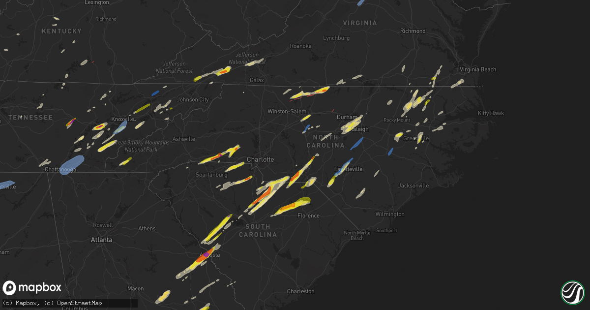
Hail Map in North Carolina on May 6, 2022
Get this storm
May 6 map
$229
one time, instant access
Download today. No call, no setup
Keep the $229
Bought the map and want the full workflow? Apply the entire $229 to a subscription within 7 days. None of it is wasted.
Every map, not just this one
This buys you this map. Subscription and you get every map we run, in the markets you choose from a few cities to whole states to nationwide. Plus real-time alerts the moment a storm fires.
Contact data
Name, contact info, occupancy, even credit band for addresses in the footprint. You go from where it hit to who to call.
Become the source they trust
Unlimited branding weather history reports on demand. You already have the documented answer ready for the property owner, and you are the one who showed up with it.
Property data and RoofTrace estimates
Pull up any address you have got, its value and the exact code rules for that jurisdiction, straight from One Click Code. Then RoofTrace estimates the squares, pitch, and roof value, priced the way you price.
Storm reports in North Carolina
North Carolina
| Date | Description |
|---|---|
| 05/06/20226:58 PM CDT | Many trees down in the area from asheboro to randleman and ramseur. Time estimated from radar. |
| 05/06/20226:51 PM CDT | Medium to large trees and power lines down in north wilkesboro... Hays... Northern wilkes county... Nc. Time is estimated... Report via vfd. |
| 05/06/20226:49 PM CDT | Thunderstorm winds blew down at least ten trees and multiple power lines. Several roads are blocked due to the downed trees and power lines. |
| 05/06/20226:45 PM CDT | Tree down on seven island road. |
| 05/06/20226:45 PM CDT | A local report indicates 1.50 inch wind near 1 N WENTWORTH |
| 05/06/20226:44 PM CDT | The rated ef-1 tornado touched down in a wooded area just southwest of sunset view road... |
| 05/06/20226:44 PM CDT | Tree on home in seagrove. |
| 05/06/20226:38 PM CDT | Several trees down ahead of a slowly weakening line of storms. On baton school road. Posted on facebook. |
| 05/06/20226:37 PM CDT | Tree down on decal lane. |
| 05/06/20226:31 PM CDT | Report from mping: quarter |
| 05/06/20226:30 PM CDT | Reports of trees down in eastern part of county. |
| 05/06/20226:30 PM CDT | Multiple large trees reported down near downtown troy... Nc. |
| 05/06/20226:28 PM CDT | A local report indicates 1.50 inch wind near MAYODAN |
| 05/06/20226:26 PM CDT | A local report indicates 1.50 inch wind near 1 NE MADISON |
| 05/06/20226:26 PM CDT | Multiple trees down across the city of fayetteville. |
| 05/06/20226:25 PM CDT | Tree down along highway 52 south. |
| 05/06/20226:25 PM CDT | Tree down on dodson mill road. |
| 05/06/20226:23 PM CDT | Tree down near volunteer road and tillotson road. |
| 05/06/20226:22 PM CDT | Golf ball size hail reported at the intersection of allison road and lake road. |
| 05/06/20226:20 PM CDT | A local report indicates 1.00 inch wind near 2 SE DILLARD |
| 05/06/20226:18 PM CDT | Report from mping: 3-inch tree limbs broken; power poles broken. |
| 05/06/20226:18 PM CDT | Report from mping: quarter |
| 05/06/20226:18 PM CDT | Partial roof collapse and tree on house in western fayetteville. |
| 05/06/20226:17 PM CDT | Thunderstorm winds blew two trees down on idlewild road. |
| 05/06/20226:15 PM CDT | Multiple trees/powerlines reported down near ellerbe... Nc. |
| 05/06/20226:10 PM CDT | Tree down on hogan creek road. |
| 05/06/20226:09 PM CDT | Multiple trees down centered around koonce road and phillipi church road. Time estimated by radar. |
| 05/06/20226:03 PM CDT | Tree down near stuart road and willow bend drive. |
| 05/06/20225:58 PM CDT | Moore county deputy encountered golf ball sized hail near eagle springs. Time estimated by radar. |
| 05/06/20225:55 PM CDT | At least 2 trees down with one large tree snapped. |
| 05/06/20225:55 PM CDT | Corrects previous hail report from 2 wsw fountain. Trained spotter reported quarter size hail along highway 222 in pitt county. |
| 05/06/20225:51 PM CDT | Quarter size hail reported just north of saratoga via twitter picture. |
| 05/06/20225:50 PM CDT | Numerous reports of trees down in the waxhaw to monroe areas. Time estimated from radar. |
| 05/06/20225:40 PM CDT | Reported quarter size hail and estimated wind gusts of 60 mph near the intersection of landsford road and sc hwy. 207. |
| 05/06/20225:30 PM CDT | Trees down across the county. Time estimated from radar. |
| 05/06/20225:29 PM CDT | Roof partially blown off house. No injuries reported at this time. |
| 05/06/20225:25 PM CDT | Estimated golf ball sized hail near wadesboro... Time estimated by radar. |
| 05/06/20225:25 PM CDT | Public report of golf ball sized hail near lilesville. |
| 05/06/20225:22 PM CDT | Tree fell on vehicle causing further accidents near the city of wadesboro. |
| 05/06/20225:17 PM CDT | 911 call center reports many trees down near the jones creek fish camp. Time estimated by radar. |
| 05/06/20225:05 PM CDT | Large tree fell on vehicle. Time estimated from radar. |
| 05/06/20224:56 PM CDT | A local report indicates 1.00 inch wind near 1 SW CROWDERS |
| 05/06/20224:55 PM CDT | A local report indicates 1.75 inch wind near CROUSE |
| 05/06/20224:55 PM CDT | A local report indicates 1.00 inch wind near 4 WNW LINCOLNTON |
| 05/06/20224:50 PM CDT | A local report indicates 1.75 inch wind near 4 SE VALE |
| 05/06/20224:50 PM CDT | A local report indicates 1.75 inch wind near KINGS MOUNTAIN |
| 05/06/20224:48 PM CDT | Delayed report. County dispatch reported a couple of large trees down across the road in creswell. Time estimated based off radar. |
| 05/06/20224:37 PM CDT | In ellenboro near highway 74. |
| 05/06/20224:35 PM CDT | A local report indicates 1.75 inch wind near 1 N MOORESBORO |
| 05/06/20224:35 PM CDT | Shingles blown off of a roof on a house. |
| 05/06/20224:30 PM CDT | A local report indicates 1.75 inch wind near 2 S ELLENBORO |
| 05/06/20224:30 PM CDT | Structure damage on deep creek rd. |
| 05/06/20224:13 PM CDT | Radar tds confirmed and emergency management reported residential structural damage. |
| 05/06/20224:13 PM CDT | A local report indicates 1.50 inch wind near 2 ESE TOPNOT |
| 05/06/20224:09 PM CDT | Mostly pea to marble sized hail but a few hailstones were quarter sized. |
| 05/06/20224:08 PM CDT | Major damage to a building. No injuries reported at this time. |
| 05/06/20224:00 PM CDT | Nws damage survey confirms weak tornado. |
| 05/06/20224:00 PM CDT | Tree down along highway 62s in anderson... Nc. |
| 05/06/20223:30 PM CDT | A local report indicates 1.25 inch wind near 1 ENE LASKER |
| 05/06/20223:25 PM CDT | A local report indicates 1.00 inch wind near 1 SSW LASKER |
| 05/06/20223:14 PM CDT | Report/video via social media near ahoskie. |
| 05/06/20223:10 PM CDT | Multiple trees down in the area of six forks road. Time estimated by radar. |
| 05/06/20223:07 PM CDT | A local report indicates 1.00 inch wind near 1 WNW SIMPSON |
| 05/06/20223:05 PM CDT | Local broadcast media passed along report of quarter sized hail. Time estimated by radar. |
| 05/06/20223:02 PM CDT | Power outage caused by downed objects. Time estimated by radar. |
| 05/06/20222:56 PM CDT | Trained spotter estimated half dollar sized hail near the airport. Time estimated by radar. |
| 05/06/20222:56 PM CDT | Large tree down near the airport blocking the road. |
| 05/06/20222:50 PM CDT | Trained spotter measured half dollar sized hail near cary... Nc. Time given with report. |
| 05/06/20222:46 PM CDT | Multiple reports of quarter sized hail in morrisville. |
| 05/06/20222:46 PM CDT | Krdu measured a peak wind of 55kts at 3:46pm. |
| 05/06/20222:40 PM CDT | Dime to quarter size hail. |
| 05/06/20222:39 PM CDT | Delayed report. County dispatch reported numerous trees down countywide... But mostly focused over the western and central part of the county. Time estimated based on r |
| 05/06/20222:35 PM CDT | Public observed high winds and heavy rain with hail size approximate quarter. |
| 05/06/20222:30 PM CDT | Trained spotter reported estimated 70 mph winds near oakwood school. |
| 05/06/20222:30 PM CDT | Extensive tree damage centered around lake tillery including trees on residences. Time estimated by radar. |
| 05/06/20222:28 PM CDT | Public reports quarter to half dollar size hail along sheppard mill road at heartland estate equestrian farm. Time estimated by radar. |
| 05/06/20222:25 PM CDT | Large tree down near the intersection of s talbert blvd and carolina ave. Time estimated by radar. |
| 05/06/20222:24 PM CDT | Multiple trees/powerlines reported down in lexington... Nc. |
| 05/06/20222:21 PM CDT | Trees reported down near pittsboro... Nc. |
| 05/06/20222:20 PM CDT | Corrects previous tstm wnd gst report from 4 w pitt-greenville airport. Trained spotter reported estimated 70 mph winds near oakwood school. |
| 05/06/20222:10 PM CDT | 1 inch tree limbs broken and shingles blown off. |
| 05/06/20221:45 PM CDT | Multiple trees down in the vicinity of central heights road and e new hope road east of goldsboro. |
| 05/06/20221:39 PM CDT | Kgsb measured 52kt wind gust at 1839z. |
| 05/06/20221:30 PM CDT | From 10 to 20 trees were blown down along j m craig road. A few of the trees were quite large and uprooted. A tree limb punctured the wall of an old sawmill. The trees |
| 05/06/20221:20 PM CDT | A local report indicates 1.25 inch wind near ANDREWS |
| 05/06/20224:25 AM CDT | At 924 PM EDT, a severe thunderstorm was located 10 miles west of Asheboro, moving east at 40 mph. HAZARD...60 mph wind gusts. SOURCE...Radar indicated. IMPACT...Expect damage to roofs, siding, and trees. Locations impacted include... High Point, Asheboro, Randleman, North Carolina Zoo, Thomasville, Seagrove, Archdale, Trinity, Pleasant Garden and Liberty. |
| 05/06/20224:14 AM CDT | At 913 PM EDT, a severe thunderstorm was located 8 miles northeast of Dortches, or 11 miles north of Rocky Mount, moving northeast at 55 mph. HAZARD...60 mph wind gusts. SOURCE...Radar indicated. IMPACT...Expect damage to roofs, siding, and trees. Locations impacted include... Rocky Mount, Roanoke Rapids, Henderson, Tarboro, Warrenton, Halifax, Scotland Neck, Norlina, Littleton and Enfield. |
| 05/06/20223:51 AM CDT | At 851 PM EDT, a severe thunderstorm was located 7 miles south of Creedmoor, moving northeast at 45 mph. HAZARD...60 mph wind gusts. SOURCE...Radar indicated. IMPACT...Expect damage to roofs, siding, and trees. Locations impacted include... Rocky Mount, Oxford, Nashville, Creedmoor, Louisburg, Butner, Franklinton, Dortches, Bailey and Kittrell. |
| 05/06/20223:45 AM CDT | At 845 PM EDT, a severe thunderstorm was located over Mount Olive, moving northeast at 45 mph. HAZARD...60 mph wind gusts. SOURCE...Radar indicated. IMPACT...Expect damage to roofs, siding, and trees. Locations impacted include... Goldsboro, Wilson, Mount Olive, Elm City, Fremont, Walnut Creek, Sharpsburg, Lucama, Stantonsburg and Black Creek. |
| 05/06/20223:38 AM CDT | At 837 PM EDT, a severe thunderstorm was located near Raleigh, moving northeast at 65 mph. HAZARD...60 mph wind gusts. SOURCE...Radar indicated. IMPACT...Expect damage to roofs, siding, and trees. Locations impacted include... Raleigh, Durham, Cary, Chapel Hill, Smithfield, Wake Forest, Garner, Carrboro, Fuquay-Varina and Clayton. |
| 05/06/20223:05 AM CDT | At 804 PM EDT, a severe thunderstorm was located 9 miles east of Ammon, or 14 miles south of Clinton, moving northeast at 45 mph. HAZARD...60 mph wind gusts and quarter size hail. SOURCE...Radar indicated. IMPACT...Hail damage to vehicles is expected. Expect wind damage to roofs, siding, and trees. Locations impacted include... Fayetteville, Clinton, Fort Bragg, Godwin, Pope AFB, Spring Lake, Eastover, Roseboro, Stedman and Garland. |
| 05/06/20222:57 AM CDT | At 757 PM EDT, a severe thunderstorm was located over Asheboro, moving northeast at 50 mph. HAZARD...60 mph wind gusts and quarter size hail. SOURCE...Radar indicated. IMPACT...Hail damage to vehicles is expected. Expect wind damage to roofs, siding, and trees. Locations impacted include... Burlington, Asheboro, Graham, Randleman, Gibsonville, Liberty, Ramseur, Franklinville, Swepsonville and Alamance. |
| 05/06/20222:50 AM CDT | At 750 PM EDT, a severe thunderstorm was located near Elizabethtown, moving northeast at 50 mph. HAZARD...60 mph wind gusts and quarter size hail. SOURCE...Radar indicated. IMPACT...Minor hail damage to vehicles is possible. Expect wind damage to trees and power lines. Locations impacted include... Elizabethtown, Lagoon, Ammon, White Lake and Bladen County Hospital. |
| 05/06/20222:40 AM CDT | At 739 PM EDT, a severe thunderstorm was located near Godwin, or 11 miles south of Lillington, moving northeast at 50 mph. HAZARD...60 mph wind gusts and half dollar size hail. SOURCE...Radar indicated. IMPACT...Hail damage to vehicles is expected. Expect wind damage to roofs, siding, and trees. Locations impacted include... Raleigh, Cary, Sanford, Smithfield, Pittsboro, Lillington, Garner, Fuquay-Varina, Clayton and Dunn. |
| 05/06/20222:37 AM CDT | At 737 PM EDT, a severe thunderstorm was located 4 miles southwest of Lincolnton, moving east at 40 mph. HAZARD...60 mph wind gusts and quarter size hail. SOURCE...Radar indicated. IMPACT...Minor hail damage to vehicles is expected. Expect wind damage to trees and power lines. Locations impacted include... Lincolnton, Cherryville, Westport, High Shoals, Boger City, Iron Station, Denver, Lowesville, Crouse and Terrell. |
| 05/06/20222:21 AM CDT | At 721 PM EDT, a severe thunderstorm was located 9 miles east of High Rock Lake, or 10 miles north of Badin Lake, moving northeast at 40 mph. HAZARD...60 mph wind gusts and quarter size hail. SOURCE...Radar indicated. IMPACT...Hail damage to vehicles is expected. Expect wind damage to roofs, siding, and trees. Locations impacted include... Asheboro, Randleman, Denton, Newsom, Gordontown, High Rock Boat Dock Marina, Randleman Regional Reservior Marina, Nc Wildlife Access Boat Launch, Martha and High Rock. |
| 05/06/20222:12 AM CDT | At 712 PM EDT, a severe thunderstorm was located near Clio, or 12 miles east of Bennettsville, moving northeast at 50 mph. HAZARD...70 mph wind gusts and half dollar size hail. SOURCE...Radar indicated. IMPACT...Minor hail damage to vehicles is possible. Expect considerable tree damage. Wind damage is also likely to mobile homes, roofs, and outbuildings. Locations impacted include... Lumberton, Dillon, Red Springs, Pembroke, Fairmont, Maxton, Mccoll, St. Pauls, Rowland, Clio, Rex, Hamer, South Of The Border, Hestertown, Shannon, Buie, Robeson Community College, Wakulla, Minturn and Elrod. |
| 05/06/20221:59 AM CDT | At 659 PM EDT, a severe thunderstorm was located 7 miles south of Hamlet, or 10 miles southeast of Rockingham, moving northeast at 55 mph. HAZARD...60 mph wind gusts and quarter size hail. SOURCE...Radar indicated. IMPACT...Minor hail damage to vehicles is possible. Expect wind damage to trees and power lines. This severe thunderstorm will remain over mainly rural areas of north central Marlboro County. |
| 05/06/20221:55 AM CDT | At 655 PM EDT, severe thunderstorms were located along a line extending from near Sugar Grove to 8 miles west of Marion, moving east at 30 mph. HAZARD...60 mph wind gusts. SOURCE...Radar indicated. IMPACT...Expect damage to trees and power lines. Locations impacted include... Lenoir, Morganton, Marion, Spruce Pine, Newland, Gamewell, Blowing Rock In Caldwell County, Glen Alpine, Old Fort and Banner Elk. |
| 05/06/20221:53 AM CDT | At 653 PM EDT, a severe thunderstorm was located near Farmville, moving northeast at 25 mph. HAZARD...60 mph wind gusts and half dollar size hail. SOURCE...Radar indicated. IMPACT...Hail damage to vehicles is expected. Expect wind damage to roofs, siding, and trees. Locations impacted include... Farmville, Bethel, Bruce, Fountain and Falkland. |
| 05/06/20221:53 AM CDT | At 653 PM EDT, a severe thunderstorm was located over Wakulla, or over Red Springs, moving northeast at 40 mph. HAZARD...Ping pong ball size hail and 60 mph wind gusts. SOURCE...Radar indicated. IMPACT...People and animals outdoors will be injured. Expect hail damage to roofs, siding, windows, and vehicles. Expect wind damage to roofs, siding, and trees. Locations impacted include... Fayetteville, Raeford, Fort Bragg, Antioch, Pope AFB, Hope Mills, Spring Lake, Eastover, Wade and Rockfish. |
| 05/06/20221:51 AM CDT | At 651 PM EDT, a severe thunderstorm was located 8 miles north of Shelby, or near Fallston, moving northeast at 40 mph. HAZARD...60 mph wind gusts and half dollar size hail. SOURCE...Radar indicated. IMPACT...Minor hail damage to vehicles is expected. Expect wind damage to trees and power lines. Locations impacted include... Shelby, Lincolnton, Cherryville, Maiden, Westport, Belwood, High Shoals, Lawndale, Fallston and Waco. |
| 05/06/20221:49 AM CDT | At 649 PM EDT, a severe thunderstorm was located 7 miles northwest of Farmville, moving northeast at 25 mph. HAZARD...60 mph wind gusts and quarter size hail. SOURCE...Radar indicated. IMPACT...Hail damage to vehicles is expected. Expect wind damage to roofs, siding, and trees. Locations impacted include... Princeville, Pinetops, Macclesfield, Saratoga, Conetoe and Willbanks. |
| 05/06/20221:41 AM CDT | At 639 PM EDT, severe thunderstorms were located along a line extending from 7 miles southeast of Bristol VA to Beech Mountain NC moving east at 55 mph. HAZARD...60 to 70 mph wind gusts. SOURCE...Public. IMPACT...Expect considerable tree damage. Damage is likely to mobile homes, roofs, and outbuildings. Locations impacted include... Boone... Jefferson... West Jefferson... Blowing Rock... Beech Mountain... Lansing... and Foscoe.This includes The following Location Appalachian State University. |
| 05/06/20221:37 AM CDT | At 637 PM EDT, a severe thunderstorm was located over Wallace, or near Cheraw, moving northeast at 50 mph. HAZARD...60 mph wind gusts and quarter size hail. SOURCE...Radar indicated. IMPACT...Minor hail damage to vehicles is possible. Expect wind damage to trees and power lines. Locations impacted include... Chavistown and Wallace. |
| 05/06/20221:36 AM CDT | At 636 PM EDT, a severe thunderstorm was located 13 miles northwest of Rockingham, moving northeast at 50 mph. HAZARD...Ping pong ball size hail and 60 mph wind gusts. SOURCE...Radar indicated. IMPACT...People and animals outdoors will be injured. Expect hail damage to roofs, siding, windows, and vehicles. Expect wind damage to roofs, siding, and trees. Locations impacted include... Southern Pines, Troy, Carthage, Pinehurst, Aberdeen, Biscoe, Whispering Pines, Pinebluff, Mount Gilead and Robbins. |
| 05/06/20221:35 AM CDT | At 634 PM EDT, a severe thunderstorm was located over Dovesville, or 9 miles north of Darlington, moving northeast at 45 mph. HAZARD...70 mph wind gusts and half dollar size hail. SOURCE...Radar indicated. IMPACT...Minor hail damage to vehicles is possible. Expect considerable tree damage. Wind damage is also likely to mobile homes, roofs, and outbuildings. Locations impacted include... Bennettsville, Fairmont, Maxton, Mccoll, Rowland, Clio, Hamer, Mont Clare, Brownsville, South Of The Border, Floyd, Minturn, Elrod, Dovesville, Raemon, Auburn, Bingham, Purvis, Dunbar and Little Rock. |
| 05/06/20221:29 AM CDT | At 629 PM EDT, a severe thunderstorm was located near Heath Springs, or 11 miles southeast of Lancaster, moving northeast at 70 mph. HAZARD...Ping pong ball size hail and 60 mph wind gusts. SOURCE...Radar indicated. IMPACT...People and animals outdoors will be injured. Expect hail damage to roofs, siding, windows, and vehicles. Expect wind damage to trees and powerlines. Locations impacted include... Lancaster, Pageland, Kershaw, Elgin, Heath Springs, USC Lancaster, Irwin, Buford, Jefferson, Bell Town Fire Station, Arrowood Estates, Faith Christian School, Bear Creek Park, Central High School, McDonald Green Elementary School, High Point Fire Station, Tradesville, Camp Creek Fire Station, Antioch and Kirk Air Base. |
| 05/06/20221:29 AM CDT | At 628 PM EDT, severe thunderstorms were located along a line extending from near Walnut Hill to near Elizabethton to near Bakersville, moving northeast at 50 mph. This storm has a history of producing damaging winds. HAZARD...60 mph wind gusts and penny size hail. SOURCE...Radar indicated. IMPACT...Expect damage to roofs, siding, and trees. Locations impacted include... Bristol Tn, Elizabethton, Mountain City, Bluff City, Damascus, Hunter, Morril's Cave, Roane Mountain State Park, Neva and Laurel Bloomery. |
| 05/06/20221:15 AM CDT | At 615 PM EDT, a severe thunderstorm was located near Rich Square, moving northeast at 40 mph. HAZARD...60 mph wind gusts and quarter size hail. SOURCE...Radar indicated. IMPACT...Minor damage to vehicles is possible. Expect wind damage to trees and powerlines. Locations impacted include... Ahoskie, Murfreesboro, Rich Square, Aulander, Chowan University, Conway, Woodland, Roxobel, Union, Jackson, Severn, Kelford, Lasker, Eagletown, Milwaukee, Earleys, Menola, Mapleton, Bryantown and Boones Crossroads. |
| 05/06/20221:06 AM CDT | At 606 PM EDT, a severe thunderstorm was located near Chesterfield, or 13 miles south of Wadesboro, moving northeast at 45 mph. HAZARD...60 mph wind gusts and quarter size hail. SOURCE...Radar indicated. IMPACT...Hail damage to vehicles is expected. Expect wind damage to roofs, siding, and trees. Locations impacted include... Rockingham, Wadesboro, Hamlet, Ansonville, Hoffman, Polkton, Ellerbe, Dobbins Heights, Lilesville and Morven. |
| 05/06/202212:58 AM CDT | At 558 PM EDT, severe thunderstorms were located along a line extending from near Virgilina to 9 miles east of Roxboro to near Rougemont, moving northeast at 30 mph. HAZARD...60 mph wind gusts and quarter size hail. SOURCE...Radar indicated. IMPACT...Hail damage to vehicles is expected. Expect wind damage to roofs, siding, and trees. Locations impacted include... Oxford, Rougemont, Stem, Stovall, Lake Michie, Mayo Reservoir, Bahama, Bethel Hill, Dabney and Lake Butner. |
| 05/06/202212:58 AM CDT | At 558 PM EDT, a severe thunderstorm was located near Kershaw, or 15 miles southeast of Lancaster, moving northeast at 45 mph. HAZARD...Ping pong ball size hail and 60 mph wind gusts. SOURCE...Radar indicated. IMPACT...People and animals outdoors will be injured. Expect hail damage to roofs, siding, windows, and vehicles. Expect wind damage to trees and powerlines. Locations impacted include... Pageland, Kershaw, Chesterfield, Heath Springs, Westville, Mt Pisgah, Jefferson, Ruby, Mount Croghan, Chesterfield Ruby Middle School, High Point Fire Station, Forty Acre Rock Preserve, Taxahaw, Pleasant Hill, Kershaw Correctional Institution, Chesterfield Detention Center and Central High School. |
| 05/06/202212:56 AM CDT | At 556 PM EDT, severe thunderstorms were located along a line extending from 9 miles southeast of Surgoinsville to 7 miles southwest of Jonesborough to 6 miles west of Erwin to 10 miles north of Mars Hill, moving northeast at 50 mph. HAZARD...60 mph wind gusts and quarter size hail. SOURCE...Radar indicated. IMPACT...Hail damage to vehicles is expected. Expect wind damage to roofs, siding, and trees. Locations impacted include... Johnson City, Bristol Tn, Elizabethton, Erwin, Jonesborough, Banner Hill, Central, Spurgeon, Midway and Pine Crest.This includes Interstate 26 in Tennessee between mile markers 11 and54. |
| 05/06/202212:51 AM CDT | At 551 PM EDT, a severe thunderstorm was located over Claresville, or near Emporia, moving northeast at 40 mph. HAZARD...60 mph wind gusts and quarter size hail. SOURCE...Radar indicated. IMPACT...Minor damage to vehicles is possible. Expect wind damage to trees and powerlines. This severe thunderstorm will be near... Green Plain around 555 PM EDT. Jarratt around 605 PM EDT. Sussex and Stony Creek around 625 PM EDT. Homeville around 630 PM EDT.Other locations impacted by this severe thunderstorm include AdamsGrove, Gray, Grizzard, Lanes Corner, Booker, Yale, Lumberton, BryantsCorner, Manry and Huske. |
| 05/06/202212:41 AM CDT | At 540 PM EDT, severe thunderstorms were located along a line extending from 9 miles west of Shelby to 7 miles east of Gaffney to 4 miles south of Union, moving east at 20 mph. HAZARD...Golf ball size hail and 60 mph wind gusts. SOURCE...Radar indicated. IMPACT...People and animals outdoors will be injured. Expect hail damage to roofs, siding, windows, and vehicles. Expect wind damage to trees and power lines. Locations impacted include... Gastonia, Shelby, Lincolnton, York, Kings Mountain, Cherryville, Bessemer City, South Gastonia, Tega Cay and Clover. |
| 05/06/202212:39 AM CDT | At 539 PM EDT, a severe thunderstorm was located over Lancaster, moving northeast at 50 mph. HAZARD...Ping pong ball size hail and 60 mph wind gusts. SOURCE...Radar indicated. IMPACT...People and animals outdoors will be injured. Expect hail damage to roofs, siding, windows, and vehicles. Expect wind damage to trees and powerlines. Locations impacted include... Lancaster, Elgin, USC Lancaster, Irwin, Buford, Unity Fire Station, Lancaster Mill, Arrowood Estates, Camp Creek Fire Station and McWhirter Airfield. |
| 05/06/202212:30 AM CDT | At 530 PM EDT, severe thunderstorms were located along a line extending from near Hobbsville to Winfall to near Snug Harbor, moving northeast at 30 mph. HAZARD...60 mph wind gusts and quarter size hail. SOURCE...Radar indicated. IMPACT...Minor damage to vehicles is possible. Expect wind damage to trees and powerlines. Severe thunderstorms will be near... Chapanoke around 540 PM EDT. Elizabeth City around 550 PM EDT. South Mills and Nixonton around 555 PM EDT. Elizabeth City State University and Morgans Corner around 600 PM EDT.Other locations impacted by these severe thunderstorms include BurntMills, Horseshoe, Rabbit Corner, Lynchs Corner, Peach, Whiteston,Parkville, Woodville, Nicanor and Yeopim Station. |
| 05/06/202212:23 AM CDT | At 523 PM EDT, a severe thunderstorm was located 7 miles south of Abingdon, moving east at 35 mph. HAZARD...60 mph wind gusts and quarter size hail. SOURCE...Radar indicated. IMPACT...Hail damage to vehicles is expected. Expect wind damage to roofs, siding, and trees. Locations impacted include... Damascus, Laurel Bloomery and Konnarock. |
| 05/06/202212:22 AM CDT | At 521 PM EDT, severe thunderstorms were located along a line extending from 7 miles southeast of Russellville to near Parrottsville to 9 miles northeast of Smoky Mountains-Big Creek, moving northeast at 50 mph. HAZARD...60 mph wind gusts and quarter size hail. SOURCE...Radar indicated. IMPACT...Hail damage to vehicles is expected. Expect wind damage to roofs, siding, and trees. Locations impacted include... Johnson City, Greeneville, Erwin, Jonesborough, Tusculum, Parrottsville, Banner Hill, Spurgeon, Midway and Gray.This includes the following highways... Interstate 26 in Tennessee between mile markers 10 and 23, andbetween mile markers 29 and 48. Interstate 81 in Tennessee between mile markers 44 and 46, andbetween mile markers 51 and 52. |
| 05/06/202212:21 AM CDT | At 520 PM EDT, a severe thunderstorm was located over Roper, or near Plymouth, moving northeast at 40 mph. HAZARD...60 mph wind gusts and quarter size hail. SOURCE...Radar indicated. IMPACT...Hail damage to vehicles is expected. Expect wind damage to roofs, siding, and trees. Locations impacted include... Plymouth, Alligator, Columbia, Woodley, Wenona, Newfoundland, Westover, Pleasant Grove, Scuppernong, Phelps Lake, Frying Pan Landing, Pungo Lake, Mackeys, Roper and Creswell. |
| 05/06/202212:13 AM CDT | At 513 PM EDT, a severe thunderstorm was located 10 miles south of Littleton, or 16 miles southeast of Warrenton, moving northeast at 50 mph. HAZARD...60 mph wind gusts and quarter size hail. SOURCE...Radar indicated. IMPACT...Hail damage to vehicles is expected. Expect wind damage to roofs, siding, and trees. Locations impacted include... Roanoke Rapids, Weldon, Arcola, Medoc Mountain State Park, South Weldon, Airlie, Rosemary and Roanoke Rapids Lake. |
| 05/06/202212:02 AM CDT | At 502 PM EDT, severe thunderstorms were located along a line extending from near Topnot to near Prospect Hill to near Mebane, moving east at 20 mph. HAZARD...60 mph wind gusts and quarter size hail. SOURCE...Radar indicated. IMPACT...Hail damage to vehicles is expected. Expect wind damage to roofs, siding, and trees. Locations impacted include... Roxboro, Hillsborough, Mebane, Rougemont, Concord, Haw River, Carr, Efland, Lake Michie and Eno River State Park. |
| 05/05/202211:36 PM CDT | At 434 PM EDT, a severe thunderstorm was located 8 miles west of Rich Square, moving northeast at 40 mph. Additionally, another strong to severe storm has moved into the warning area and it too will have the potential to produce severe weather. HAZARD...60 mph wind gusts and quarter size hail. SOURCE...Radar indicated. IMPACT...Hail damage to vehicles is expected. Expect wind damage to roofs, siding, and trees. Locations impacted include... Scotland Neck and Tillery. |
| 05/05/202211:26 PM CDT | At 425 PM EDT, a severe thunderstorm was located near Monroeton, or near Reidsville, moving northeast at 35 mph. HAZARD...60 mph wind gusts and quarter size hail. SOURCE...Radar indicated. IMPACT...Hail damage to vehicles is expected. Expect wind damage to roofs, siding, and trees. Locations impacted include... Reidsville... Yanceyville... Bethel... Providence... Jericho... Prospect Hill... and Camp Springs. |
| 05/05/202211:23 PM CDT | At 423 PM EDT, a severe thunderstorm was located near Scotland Neck, or 10 miles southeast of Halifax, moving northeast at 25 mph. HAZARD...60 mph wind gusts and quarter size hail. SOURCE...Radar indicated. IMPACT...Hail damage to vehicles is expected. Expect wind damage to roofs, siding, and trees. Locations impacted include... Scotland Neck and Tillery. |
| 05/05/202211:20 PM CDT | At 419 PM EDT, a severe thunderstorm was located over Rich Square, moving northeast at 45 mph. There was an additional severe thunderstorm near Scotland Neck, moving northeast of 45 mph. HAZARD...Ping pong ball size hail and 60 mph wind gusts. SOURCE...Radar indicated. IMPACT...People and animals outdoors will be injured. Expect hail damage to roofs, siding, windows, and vehicles. Expect wind damage to trees and powerlines. This severe thunderstorm will be near... Woodland around 425 PM EDT. Conway around 435 PM EDT. Murfreesboro and Chowan University around 440 PM EDT. Boykins and Como around 450 PM EDT. Newsoms around 455 PM EDT.Other locations impacted by this severe thunderstorm includeEagletown, Milwaukee, Pendleton, Potecasi, Lasker, Jackson,Bryantown, Boones Crossroads, Sunbeam and George. |
| 05/05/202211:04 PM CDT | At 404 PM EDT, severe thunderstorms were located along a line extending from House to near Black Jack, moving northeast at 35 mph. HAZARD...60 mph wind gusts and quarter size hail. SOURCE...Radar indicated. IMPACT...Hail damage to vehicles is expected. Expect wind damage to roofs, siding, and trees. Locations impacted include... Greenville, Washington, Williamston, Stokes, Robersonville, House, Pactolus, Black Jack, Old Ford, East Carolina University, Pitt Greenville Airport, Dowdy Ficklen Stadium, Gold Point, Jamesville, Grimesland, Simpson, Hamilton, Smithwick, Parmele and Everetts. |
| 05/05/202211:02 PM CDT | At 401 PM EDT, a severe thunderstorm was located 8 miles northeast of RDU International, or 9 miles north of Raleigh, moving northeast at 40 mph. HAZARD...60 mph wind gusts and quarter size hail. SOURCE...Radar indicated. Trained spotters have also reported quarter sized hail with the storm, and a wind gust of 63 mph has been observed. IMPACT...Hail damage to vehicles is expected. Expect wind damage to roofs, siding, and trees. Locations impacted include... Raleigh, Louisburg, Wake Forest, Franklinton, Kittrell, Rolesville, Youngsville, Centerville, Falls Lake State Rec Area and Ingleside. |
| 05/05/202210:55 PM CDT | At 354 PM EDT, a severe thunderstorm was located near High Point, moving northeast at 35 mph. HAZARD...60 mph wind gusts and quarter size hail. SOURCE...Radar indicated. IMPACT...Hail damage to vehicles is expected. Expect wind damage to roofs, siding, and trees. Locations impacted include... Greensboro, High Point, Burlington, Graham, McLeansville, Elon, Archdale, Gibsonville, Pleasant Garden and Jamestown. |
| 05/05/202210:49 PM CDT | At 349 PM EDT, a severe thunderstorm was located over Lewiston Woodville, or 10 miles southwest of Aulander, moving northeast at 40 mph. HAZARD...60 mph wind gusts and quarter size hail. SOURCE...Radar indicated. IMPACT...Minor damage to vehicles is possible. Expect wind damage to trees and powerlines. This severe thunderstorm will be near... Roxobel around 355 PM EDT. Aulander around 405 PM EDT. Ahoskie around 415 PM EDT.Other locations impacted by this severe thunderstorm includeEagletown, Kelford, Earleys, George, Saint John, Potecasi, Menola,Millennium and Poor Town. |
| 05/05/202210:29 PM CDT | At 329 PM EDT, a severe thunderstorm was located 7 miles northeast of Etowah, or 9 miles south of Madisonville, moving northeast at 40 mph. HAZARD...60 mph wind gusts and half dollar size hail. SOURCE...Radar indicated. IMPACT...Hail damage to vehicles is expected. Expect wind damage to roofs, siding, and trees. Locations impacted include... Maryville, Madisonville, Eagleton Village, Smoky Mountains-Twentymile Creek, Smoky Mountains-Fontana Area, Englewood, Vonore, Tellico Plains, Fort Loudon State Park and Tariffville. |
| 05/05/202210:26 PM CDT | At 326 PM EDT, a severe thunderstorm was located near Robersonville, or 12 miles west of Williamston, moving northeast at 30 mph. HAZARD...60 mph wind gusts and quarter size hail. SOURCE...Radar indicated. IMPACT...Minor damage to vehicles is possible. Expect wind damage to trees and powerlines. This severe thunderstorm will be near... Lewiston Woodville around 355 PM EDT.Other locations impacted by this severe thunderstorm includeRepublican, Quitsna and Burden. |
| 05/05/202210:25 PM CDT | At 324 PM EDT, a severe thunderstorm was located 7 miles southeast of Pittsboro, moving northeast at 50 mph. HAZARD...60 mph wind gusts and quarter size hail. SOURCE...Radar indicated. IMPACT...Hail damage to vehicles is expected. Expect wind damage to roofs, siding, and trees. Locations impacted include... Raleigh, Durham, Cary, Chapel Hill, Sanford, Pittsboro, Carrboro, RDU International, Apex and Morrisville. |
| 05/05/202210:24 PM CDT | At 324 PM EDT, a severe thunderstorm was located over Stokes, or 12 miles southwest of Williamston, moving northeast at 35 mph. HAZARD...60 mph wind gusts and half dollar size hail. SOURCE...Radar indicated. IMPACT...Hail damage to vehicles is expected. Expect wind damage to roofs, siding, and trees. Locations impacted include... Williamston, Jamesville, Smithwick, Everetts and Beargrass. |
| 05/05/202210:14 PM CDT | At 314 PM EDT, a severe thunderstorm was located over Lexington, moving northeast at 50 mph. HAZARD...60 mph wind gusts and quarter size hail. SOURCE...Radar indicated. IMPACT...Hail damage to vehicles is expected. Expect wind damage to roofs, siding, and trees. Locations impacted include... Greensboro, Winston-Salem, High Point, Lexington, Thomasville, Kernersville, Linwood, McLeansville, Archdale and Summerfield. |
| 05/05/202210:12 PM CDT | At 312 PM EDT, a severe thunderstorm was located near Lizzie, or 7 miles southwest of Farmville, moving northeast at 35 mph. HAZARD...60 mph wind gusts and quarter size hail. SOURCE...Radar indicated. IMPACT...Hail damage to vehicles is expected. Expect wind damage to roofs, siding, and trees. Locations impacted include... Greenville, Williamston, Farmville, Bethel, Stokes, Snow Hill, Bell Arthur, Robersonville, House, Bruce, Maury, Ormondsville, Roundtree, Lizzie, Pitt Greenville Airport, Dowdy Ficklen Stadium, East Carolina University, Gold Point, Fountain and Hookerton. |
| 05/05/202210:08 PM CDT | At 308 PM EDT, a severe thunderstorm was located near Ayden, moving northeast at 25 mph. HAZARD...60 mph wind gusts and quarter size hail. SOURCE...Radar indicated. IMPACT...Hail damage to vehicles is expected. Expect wind damage to roofs, siding, and trees. Locations impacted include... Greenville, Washington, Winterville, Ayden, River Road, Grifton, Shelmerdine, Calico, Pactolus, Black Jack, Bunyan, Old Ford, Chocowinity, Washington Park, Grimesland, Simpson and Gardnerville. |
| 05/05/20229:40 PM CDT | At 239 PM EDT, a severe thunderstorm was located near Goldston, or 7 miles southeast of Siler City, moving northeast at 35 mph. HAZARD...60 mph wind gusts and quarter size hail. SOURCE...Radar indicated. IMPACT...Hail damage to vehicles is expected. Expect wind damage to roofs, siding, and trees. Locations impacted include... Chapel Hill, Pittsboro, Carrboro, Goldston, Jordan Lake, Crosswinds Boating Center, Jordan Lake State Rec Area, Bynum, Seaforth Boat Dock and Crosswinds Campground. |
| 05/05/20229:36 PM CDT | At 236 PM EDT, a severe thunderstorm was located 11 miles northwest of Kannapolis, or 5 miles northeast of Mooresville, moving northeast at 30 mph. HAZARD...60 mph wind gusts and quarter size hail. SOURCE...Radar indicated. IMPACT...Minor hail damage to vehicles is expected. Expect wind damage to trees and power lines. Locations impacted include... Mocksville, Mooresville, Cooleemee, Cleveland, Fork Church, Mount Ulla, Piedmont Research Station, Woodleaf, Cool Springs and Salisbury. |
| 05/05/20229:29 PM CDT | At 228 PM EDT, a severe thunderstorm was located near Andrews, moving east at 35 mph. HAZARD...60 mph wind gusts and quarter size hail. SOURCE...Radar indicated. IMPACT...Minor hail damage to vehicles is expected. Expect wind damage to trees and power lines. Locations impacted include... Nantahala Lake, Wesser, Almond, Burningtown, Kyle, Nantahala and Aquone. |
| 05/05/20229:24 PM CDT | At 224 PM EDT, a severe thunderstorm was located near Mount Olive, moving northeast at 25 mph. HAZARD...60 mph wind gusts and quarter size hail. SOURCE...Radar indicated. IMPACT...Hail damage to vehicles is expected. Expect wind damage to roofs, siding, and trees. Locations impacted include... Goldsboro, Mount Olive, Walnut Creek, Mar-Mac, Brogden, Cliffs Of The Neuse State Park and Elroy. |
| 05/05/20229:18 PM CDT | At 218 PM EDT, a severe thunderstorm was located near Andrews, moving northeast at 45 mph. HAZARD...60 mph wind gusts and quarter size hail. SOURCE...Radar indicated. IMPACT...Hail damage to vehicles is expected. Expect wind damage to roofs, siding, and trees. Locations impacted include... Andrews, Marble and Topton. |
| 05/05/20228:56 PM CDT | At 155 PM EDT, a severe thunderstorm was located 6 miles north of Gastonia, or near Stanley, moving northeast at 40 mph. HAZARD...60 mph wind gusts and quarter size hail. SOURCE...Radar indicated. IMPACT...Minor hail damage to vehicles is expected. Expect wind damage to trees and power lines. Locations impacted include... Statesville, Dallas, Stanley, Lowell, Ranlo, Westport, Troutman, Catawba, High Shoals and Mcadenville. |
| 05/05/20228:55 PM CDT | Agricultural storage building was knocked down. One additional outbuilding was damaged with roofing blown off. Tree limbs were blown off with one tree knocked over. |
| 05/05/20228:42 PM CDT | Multiple trees blown down along highway 97 in hobgood. Time estimated by radar. |
| 05/05/20228:30 PM CDT | Report from mping: trees uprooted or snapped; roof blown off. |
| 05/05/20228:30 PM CDT | Multiple trees down across edgecombe county. |
| 05/05/20228:04 PM CDT | Gsb asos reports gust of 51.0 knots. |
| 05/05/20227:56 PM CDT | Trees reported down near bennett... Nc. |
| 05/05/20227:47 PM CDT | Trees reported down near siler city... Nc. |
| 05/05/20227:40 PM CDT | Second wind gust of 60+ mph hitting krdu asos today. |
| 05/05/20227:30 PM CDT | Multiple trees/powerlines reported down just north of turkey... Nc. |
| 05/05/20227:30 PM CDT | Multiple trees and powerlines reported down in the lake artesia road area. |
| 05/05/20227:30 PM CDT | Multiple trees and powerlines reported down in the dave bright road area. |
| 05/05/20227:25 PM CDT | A local report indicates 1.25 inch wind near 2 SSE PROVIDENCE |
| 05/05/20227:20 PM CDT | Trees reported down near pittsboro... Nc. |
| 05/05/20227:20 PM CDT | Several very large trees snapped off and uprooted in a very small area. A roof blown off. Very localized as no apparent damage just a short distance away. Narrow line o |
| 05/05/20227:13 PM CDT | Social media photo showing multiple large hail stones in pelham. |
| 05/05/20227:13 PM CDT | Power outages east of angier caused by fallen trees damaging equipment. |
| 05/05/20227:13 PM CDT | A local report indicates 1.75 inch wind near 1 NNW PELHAM |
| 05/05/20227:12 PM CDT | A local report indicates 1.00 inch wind near 2 NE LAWSONVILLE |
| 05/05/20227:10 PM CDT | Measured hailstones shown on facebook. |
| 05/05/20227:10 PM CDT | Power lines were blown by thunderstorm winds along quick road. |
| 05/05/20227:07 PM CDT | A local report indicates 2.00 inch wind near 2 NE RUFFIN |
All States Impacted by Hail Map on May 6, 2022
Cities Impacted by Hail Map on May 6, 2022
- Monroe, TN
- Greeneville, TN
- Mosheim, TN
- Del Rio, TN
- Liberty, KY
- Clarkson, KY
- Leitchfield, KY
- Pittsboro, NC
- Bear Creek, NC
- Siler City, NC
- Bennett, NC
- Macclesfield, NC
- Wilson, NC
- Fountain, NC
- Stantonsburg, NC
- Walstonburg, NC
- Ahoskie, NC
- Plymouth, NC
- Cadiz, KY
- Pigeon Forge, TN
- Sevierville, TN
- Sylvania, GA
- Allendale, SC
- Blanch, NC
- Madison, NC
- Mayodan, NC
- Providence, NC
- Pelham, NC
- Milton, NC
- Stoneville, NC
- Walnut Cove, NC
- Reidsville, NC
- Yanceyville, NC
- Ruffin, NC
- Pine Hall, NC
- Shannon, NC
- Fayetteville, NC
- Raeford, NC
- Lumber Bridge, NC
- Lafitte, LA
- Barataria, LA
- Scottsburg, VA
- Virgilina, VA
- Red Oak, VA
- Clarksville, VA
- Skipwith, VA
- New Market, TN
- Strawberry Plains, TN
- Birchwood, TN
- Decatur, TN
- Staley, NC
- Liberty, NC
- Prosperity, SC
- Leesville, SC
- Mount Gilead, NC
- Swainsboro, GA
- Alamo, GA
- Mount Vernon, GA
- Vidalia, GA
- Twin City, GA
- Ailey, GA
- Tarrytown, GA
- Portal, GA
- Glenwood, GA
- Lyons, GA
- Metter, GA
- McRae Helena, GA
- Englewood, TN
- Tellico Plains, TN
- Madisonville, TN
- Vonore, TN
- Windsor, NC
- Augusta, GA
- Blythe, GA
- Pitts, GA
- Rochelle, GA
- Pineview, GA
- Abbeville, GA
- Loudon, TN
- Lenoir City, TN
- Kingston, TN
- Philadelphia, TN
- Ten Mile, TN
- Vienna, GA
- Chester, SC
- McConnells, SC
- Rock Hill, SC
- Buffalo, SC
- Union, SC
- Sharon, SC
- Lockhart, SC
- Briceville, TN
- Ward, SC
- Crossville, TN
- Irwinton, GA
- Tennille, GA
- Wrightsville, GA
- Montrose, GA
- Dublin, GA
- Toomsboro, GA
- Dudley, GA
- East Dublin, GA
- Omega, GA
- Doerun, GA
- Sylvester, GA
- Ty Ty, GA
- Tifton, GA
- Sumner, GA
- Robersonville, NC
- Williamston, NC
- Clinton, NC
- Turkey, NC
- Westfield, NC
- Danbury, NC
- Lawsonville, NC
- Abingdon, VA
- Bristol, TN
- Morgantown, KY
- New Hope, KY
- Loretto, KY
- Ayden, NC
- Sardis, GA
- Sweeny, TX
- Garysburg, NC
- Jackson, NC
- Tyler, TX
- Lindale, TX
- Battleboro, NC
- Murfreesboro, NC
- Como, NC
- Rich Square, NC
- Halifax, NC
- Whitakers, NC
- Enfield, NC
- Conway, NC
- Seaboard, NC
- Woodland, NC
- Scotland Neck, NC
- Tarboro, NC
- Marble, NC
- Andrews, NC
- Murphy, NC
- Rockingham, NC
- Bennettsville, SC
- Wallace, SC
- Hamlet, NC
- Laurel Hill, NC
- Laurel Springs, NC
- Wytheville, VA
- Pulaski, VA
- Draper, VA
- Max Meadows, VA
- Corapeake, NC
- Chesapeake, VA
- Suffolk, VA
- Winterville, NC
- Byrdstown, TN
- Pioneer, TN
- Avera, GA
- Louisville, GA
- Trenton, SC
- Sandersville, GA
- Hephzibah, GA
- Matthews, GA
- Gibson, GA
- Stapleton, GA
- Warthen, GA
- Graniteville, SC
- Beech Island, SC
- Aiken, SC
- Davisboro, GA
- Wrens, GA
- North Augusta, SC
- Keysville, GA
- Sweetwater, TN
- Niota, TN
- Parrottsville, TN
- Uvalda, GA
- Smyrna, SC
- Gaffney, SC
- York, SC
- Clover, SC
- Gastonia, NC
- Blacksburg, SC
- Pinetops, NC
- Jonesville, SC
- Enoree, SC
- Maxton, NC
- Red Springs, NC
- Jamesville, NC
- Edgefield, SC
- Clarks Hill, SC
- Johnston, SC
- Saluda, SC
- Batesburg, SC
- Newberry, SC
- Fairhope, AL
- Greenville, NC
- Emporia, VA
- Lancing, TN
- Unadilla, GA
- Pinehurst, GA
- Newsoms, VA
- Franklin, VA
- Youngsville, NC
- Perry, FL
- Lamont, FL
- Lancaster, SC
- Destin, FL
- Miramar Beach, FL
- Franklinville, NC
- Randleman, NC
- Modoc, SC
- Columbia, KY
- South Boston, VA
- Alton, VA
- Ridgeway, SC
- Monticello, KY
- Nancy, KY
- Gainesboro, TN
- Kelford, NC
- Aulander, NC
- Lewiston Woodville, NC
- Knoxville, TN
- Henderson, TN
- Tracy City, TN
- Sewanee, TN
- South Pittsburg, TN
- Whitwell, TN
- Sequatchie, TN
- Jetson, KY
- Roundhill, KY
- Bowling Green, KY
- Merry Hill, NC
- Athens, TN
- Windsor, VA
- Zuni, VA
- Albany, KY
- Hollister, NC
- Warrenton, NC
- Surgoinsville, TN
- Rogersville, TN
- Eidson, TN
- Ellenboro, NC
- Forest City, NC
- Rutherfordton, NC
- Columbus, NC
- Campobello, SC
- Chesnee, SC
- Mooresboro, NC
- Landrum, SC
- Cherryville, NC
- Lincolnton, NC
- Lawndale, NC
- Crouse, NC
- Shelby, NC
- Elko, GA
- Hawkinsville, GA
- Riceville, TN
- Tallassee, TN
- Leesburg, GA
- Chapin, SC
- Society Hill, SC
- Cassatt, SC
- Bethune, SC
- Darlington, SC
- Camden, SC
- Hartsville, SC
- Bishopville, SC
- McBee, SC
- Grimesland, NC
- Bethel, NC
- Greenback, TN
- Maryville, TN
- Greensboro, NC
- Winnsboro, SC
- Jamestown, NC
- High Point, NC
- Pleasant Garden, NC
- Freeman, VA
- Jarratt, VA
- McKenney, VA
- Stokes, NC
- Ambrose, GA
- Alapaha, GA
- Enigma, GA
- Wray, GA
- Ocilla, GA
- Wadesboro, NC
- Springfield, KY
- Bardstown, KY
- Asheboro, NC
- Heppner, OR
- Lyles, TN
- Eagle Springs, NC
- West End, NC
- Carthage, NC
- Spray, OR
- Monument, OR
- Anthony, FL
- Pearland, TX
- Fresno, TX
- Rosharon, TX
- Missouri City, TX
- Manvel, TX
- Glade Spring, VA
- Chilhowie, VA
- Marion, VA
- Watertown, TN
- Milton, TN
- Mount Croghan, SC
- Ellerbe, NC
- Jackson Springs, NC
- Chesterfield, SC
- Morven, NC
- Candor, NC
- Lilesville, NC
- Ruby, SC
- Newport, TN
- Bybee, TN
- Midway, TN
- Mohawk, TN
- Gillett, TX
- Karnes City, TX
- Saltville, VA
- Bristol, VA
- Meadowview, VA
- Adrian, GA
- Eden, NC
- Spring City, TN
- Dayton, TN
- Evensville, TN
- Morrisville, NC
- New Hill, NC
- Apex, NC
- Chapel Hill, NC
- Wake Forest, NC
- Cary, NC
- Durham, NC
- Raleigh, NC
- Heath Springs, SC
- Monroe, NC
- Jefferson, SC
- Great Falls, SC
- Marshville, NC
- Peachland, NC
- Pageland, SC
- Kershaw, SC
- Liberty Hill, SC
- Fort Lawn, SC
- Robertsdale, AL
- Summerdale, AL
- Huntsville, TN
- Perkins, GA
- Midville, GA
- Millen, GA
- Edgewater, FL
- Elizabethtown, NC
- Bristol, FL
- Hosford, FL
- Silverhill, AL
- Carrsville, VA
- Courtland, VA
- Bladenboro, NC
- Clarkton, NC
- Irmo, SC
- Little Mountain, SC
- Marietta, SC
- Travelers Rest, SC
- Rockford, TN
- Blythewood, SC
- Polkton, NC
- Bloomington Springs, TN
- Buffalo Valley, TN
- Baxter, TN
- Granville, TN
- Pilot Rock, OR
- Pendleton, OR
- Lexington, OR
- Weston, OR
- Mendota, VA
- Tryon, NC
- Cheraw, SC
- Mooresburg, TN
- Sneedville, TN
- Thorn Hill, TN
- Fort Oglethorpe, GA
- Cleveland, TN
- Apison, TN
- Chickamauga, GA
- Georgetown, TN
- Chattanooga, TN
- Ringgold, GA
- McDonald, TN
- Rossville, GA
- Lupton City, TN
- Ooltewah, TN
- Charleston, TN
- Hixson, TN
- Harrison, TN
- Alcoa, TN
- Louisville, TN
- Friendsville, TN
- Morristown, TN
- Talbott, TN
- Jefferson City, TN
- Stokesdale, NC
- Efland, NC
- Mebane, NC
- Daphne, AL
- Mobile, AL
- Bronston, KY
- Burnside, KY
- Spokane, WA
- Milton Freewater, OR
- Dudley, NC
- Goldsboro, NC
- Fort Bragg, NC
- Linden, NC
- Sophia, NC
- Garner, NC
- Willow Spring, NC
- Angier, NC
- Coats, NC
- Lillington, NC
- Earlysville, VA
- Charlottesville, VA
- North Garden, VA
- Belle Chasse, LA
- Huntsville, AL
- Harvest, AL
- Tanner, AL
- Gurley, AL
- Athens, AL
- Hollytree, AL
- Brownsboro, AL
- Madison, AL
- New Market, AL
- Grovetown, GA
- Germanton, NC
- Danville, VA
- Ringgold, VA
- Kings Mountain, NC
- Bessemer City, NC
- Harrison, GA
- Sandy Ridge, NC
- Spencer, VA
- Ridgeway, VA
- Afton, TN
- Chuckey, TN


