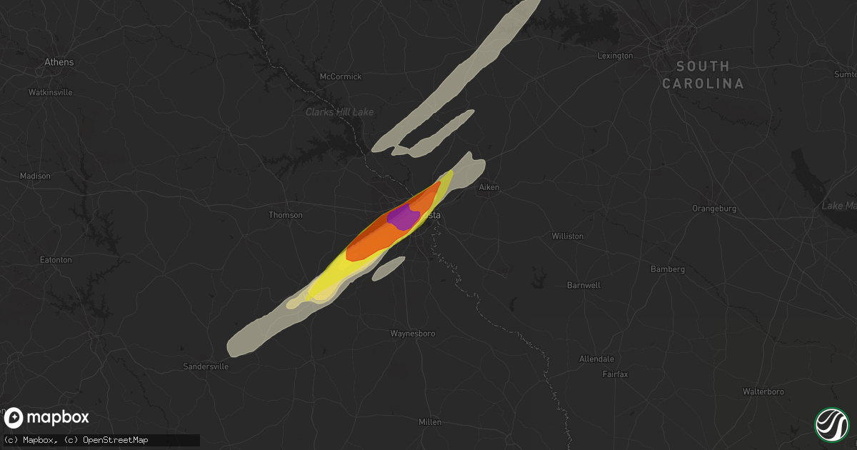
Hail Map in Augusta, GA on May 6, 2022
Get this storm
May 6 map
$229
one time, instant access
Download today. No call, no setup
Keep the $229
Bought the map and want the full workflow? Apply the entire $229 to a subscription within 7 days. None of it is wasted.
Every map, not just this one
This buys you this map. Subscription and you get every map we run, in the markets you choose from a few cities to whole states to nationwide. Plus real-time alerts the moment a storm fires.
Contact data
Name, contact info, occupancy, even credit band for addresses in the footprint. You go from where it hit to who to call.
Become the source they trust
Unlimited branding weather history reports on demand. You already have the documented answer ready for the property owner, and you are the one who showed up with it.
Property data and RoofTrace estimates
Pull up any address you have got, its value and the exact code rules for that jurisdiction, straight from One Click Code. Then RoofTrace estimates the squares, pitch, and roof value, priced the way you price.
Storm reports in Augusta, GA
Augusta, GA
| Date | Description |
|---|---|
| 05/06/20223:47 PM CDT | Reported quarter size hail at augusta university. |
| 05/06/20223:47 PM CDT | Public reported through social media of egg size hail neaer the university hospital and wrightsboro road. |
| 05/06/20223:46 PM CDT | Reported golf ball size hail along summer ridge drive in augusta. |
| 05/06/20223:45 PM CDT | Public reported through social media of large hail that ranged from 1 inch up to just over 2 inches along pennsylvania avenue near clifton street. |
| 05/06/20223:45 PM CDT | Golf ball sized hail and 50 mph wind gusts reported near augusta national golf course. |
| 05/06/20223:45 PM CDT | Reported a large tree down across river north driver in north augusta. |
| 05/06/20223:44 PM CDT | Reported golf ball size hail at daniel field. |
| 05/06/20223:43 PM CDT | Report from media of hail just larger than 2 inches at the first baptist church at wheeler road and jackson road. |
| 05/06/20223:41 PM CDT | Reported half dollar size hail at fort gordon. |
All States Impacted by Hail Map on May 6, 2022
All Cities Impacted by Hail Map on May 6, 2022
- Monroe, TN
- Greeneville, TN
- Mosheim, TN
- Del Rio, TN
- Liberty, KY
- Clarkson, KY
- Leitchfield, KY
- Pittsboro, NC
- Bear Creek, NC
- Siler City, NC
- Bennett, NC
- Macclesfield, NC
- Wilson, NC
- Fountain, NC
- Stantonsburg, NC
- Walstonburg, NC
- Ahoskie, NC
- Plymouth, NC
- Cadiz, KY
- Pigeon Forge, TN
- Sevierville, TN
- Sylvania, GA
- Allendale, SC
- Blanch, NC
- Madison, NC
- Mayodan, NC
- Providence, NC
- Pelham, NC
- Milton, NC
- Stoneville, NC
- Walnut Cove, NC
- Reidsville, NC
- Yanceyville, NC
- Ruffin, NC
- Pine Hall, NC
- Shannon, NC
- Fayetteville, NC
- Raeford, NC
- Lumber Bridge, NC
- Lafitte, LA
- Barataria, LA
- Scottsburg, VA
- Virgilina, VA
- Red Oak, VA
- Clarksville, VA
- Skipwith, VA
- New Market, TN
- Strawberry Plains, TN
- Birchwood, TN
- Decatur, TN
- Staley, NC
- Liberty, NC
- Prosperity, SC
- Leesville, SC
- Mount Gilead, NC
- Swainsboro, GA
- Alamo, GA
- Mount Vernon, GA
- Vidalia, GA
- Twin City, GA
- Ailey, GA
- Tarrytown, GA
- Portal, GA
- Glenwood, GA
- Lyons, GA
- Metter, GA
- McRae Helena, GA
- Englewood, TN
- Tellico Plains, TN
- Madisonville, TN
- Vonore, TN
- Windsor, NC
- Augusta, GA
- Blythe, GA
- Pitts, GA
- Rochelle, GA
- Pineview, GA
- Abbeville, GA
- Loudon, TN
- Lenoir City, TN
- Kingston, TN
- Philadelphia, TN
- Ten Mile, TN
- Vienna, GA
- Chester, SC
- McConnells, SC
- Rock Hill, SC
- Buffalo, SC
- Union, SC
- Sharon, SC
- Lockhart, SC
- Briceville, TN
- Ward, SC
- Crossville, TN
- Irwinton, GA
- Tennille, GA
- Wrightsville, GA
- Montrose, GA
- Dublin, GA
- Toomsboro, GA
- Dudley, GA
- East Dublin, GA
- Omega, GA
- Doerun, GA
- Sylvester, GA
- Ty Ty, GA
- Tifton, GA
- Sumner, GA
- Robersonville, NC
- Williamston, NC
- Clinton, NC
- Turkey, NC
- Westfield, NC
- Danbury, NC
- Lawsonville, NC
- Abingdon, VA
- Bristol, TN
- Morgantown, KY
- New Hope, KY
- Loretto, KY
- Ayden, NC
- Sardis, GA
- Sweeny, TX
- Garysburg, NC
- Jackson, NC
- Tyler, TX
- Lindale, TX
- Battleboro, NC
- Murfreesboro, NC
- Como, NC
- Rich Square, NC
- Halifax, NC
- Whitakers, NC
- Enfield, NC
- Conway, NC
- Seaboard, NC
- Woodland, NC
- Scotland Neck, NC
- Tarboro, NC
- Marble, NC
- Andrews, NC
- Murphy, NC
- Rockingham, NC
- Bennettsville, SC
- Wallace, SC
- Hamlet, NC
- Laurel Hill, NC
- Laurel Springs, NC
- Wytheville, VA
- Pulaski, VA
- Draper, VA
- Max Meadows, VA
- Corapeake, NC
- Chesapeake, VA
- Suffolk, VA
- Winterville, NC
- Byrdstown, TN
- Pioneer, TN
- Avera, GA
- Louisville, GA
- Trenton, SC
- Sandersville, GA
- Hephzibah, GA
- Matthews, GA
- Gibson, GA
- Stapleton, GA
- Warthen, GA
- Graniteville, SC
- Beech Island, SC
- Aiken, SC
- Davisboro, GA
- Wrens, GA
- North Augusta, SC
- Keysville, GA
- Sweetwater, TN
- Niota, TN
- Parrottsville, TN
- Uvalda, GA
- Smyrna, SC
- Gaffney, SC
- York, SC
- Clover, SC
- Gastonia, NC
- Blacksburg, SC
- Pinetops, NC
- Jonesville, SC
- Enoree, SC
- Maxton, NC
- Red Springs, NC
- Jamesville, NC
- Edgefield, SC
- Clarks Hill, SC
- Johnston, SC
- Saluda, SC
- Batesburg, SC
- Newberry, SC
- Fairhope, AL
- Greenville, NC
- Emporia, VA
- Lancing, TN
- Unadilla, GA
- Pinehurst, GA
- Newsoms, VA
- Franklin, VA
- Youngsville, NC
- Perry, FL
- Lamont, FL
- Lancaster, SC
- Destin, FL
- Miramar Beach, FL
- Franklinville, NC
- Randleman, NC
- Modoc, SC
- Columbia, KY
- South Boston, VA
- Alton, VA
- Ridgeway, SC
- Monticello, KY
- Nancy, KY
- Gainesboro, TN
- Kelford, NC
- Aulander, NC
- Lewiston Woodville, NC
- Knoxville, TN
- Henderson, TN
- Tracy City, TN
- Sewanee, TN
- South Pittsburg, TN
- Whitwell, TN
- Sequatchie, TN
- Jetson, KY
- Roundhill, KY
- Bowling Green, KY
- Merry Hill, NC
- Athens, TN
- Windsor, VA
- Zuni, VA
- Albany, KY
- Hollister, NC
- Warrenton, NC
- Surgoinsville, TN
- Rogersville, TN
- Eidson, TN
- Ellenboro, NC
- Forest City, NC
- Rutherfordton, NC
- Columbus, NC
- Campobello, SC
- Chesnee, SC
- Mooresboro, NC
- Landrum, SC
- Cherryville, NC
- Lincolnton, NC
- Lawndale, NC
- Crouse, NC
- Shelby, NC
- Elko, GA
- Hawkinsville, GA
- Riceville, TN
- Tallassee, TN
- Leesburg, GA
- Chapin, SC
- Society Hill, SC
- Cassatt, SC
- Bethune, SC
- Darlington, SC
- Camden, SC
- Hartsville, SC
- Bishopville, SC
- McBee, SC
- Grimesland, NC
- Bethel, NC
- Greenback, TN
- Maryville, TN
- Greensboro, NC
- Winnsboro, SC
- Jamestown, NC
- High Point, NC
- Pleasant Garden, NC
- Freeman, VA
- Jarratt, VA
- McKenney, VA
- Stokes, NC
- Ambrose, GA
- Alapaha, GA
- Enigma, GA
- Wray, GA
- Ocilla, GA
- Wadesboro, NC
- Springfield, KY
- Bardstown, KY
- Asheboro, NC
- Heppner, OR
- Lyles, TN
- Eagle Springs, NC
- West End, NC
- Carthage, NC
- Spray, OR
- Monument, OR
- Anthony, FL
- Pearland, TX
- Fresno, TX
- Rosharon, TX
- Missouri City, TX
- Manvel, TX
- Glade Spring, VA
- Chilhowie, VA
- Marion, VA
- Watertown, TN
- Milton, TN
- Mount Croghan, SC
- Ellerbe, NC
- Jackson Springs, NC
- Chesterfield, SC
- Morven, NC
- Candor, NC
- Lilesville, NC
- Ruby, SC
- Newport, TN
- Bybee, TN
- Midway, TN
- Mohawk, TN
- Gillett, TX
- Karnes City, TX
- Saltville, VA
- Bristol, VA
- Meadowview, VA
- Adrian, GA
- Eden, NC
- Spring City, TN
- Dayton, TN
- Evensville, TN
- Morrisville, NC
- New Hill, NC
- Apex, NC
- Chapel Hill, NC
- Wake Forest, NC
- Cary, NC
- Durham, NC
- Raleigh, NC
- Heath Springs, SC
- Monroe, NC
- Jefferson, SC
- Great Falls, SC
- Marshville, NC
- Peachland, NC
- Pageland, SC
- Kershaw, SC
- Liberty Hill, SC
- Fort Lawn, SC
- Robertsdale, AL
- Summerdale, AL
- Huntsville, TN
- Perkins, GA
- Midville, GA
- Millen, GA
- Edgewater, FL
- Elizabethtown, NC
- Bristol, FL
- Hosford, FL
- Silverhill, AL
- Carrsville, VA
- Courtland, VA
- Bladenboro, NC
- Clarkton, NC
- Irmo, SC
- Little Mountain, SC
- Marietta, SC
- Travelers Rest, SC
- Rockford, TN
- Blythewood, SC
- Polkton, NC
- Bloomington Springs, TN
- Buffalo Valley, TN
- Baxter, TN
- Granville, TN
- Pilot Rock, OR
- Pendleton, OR
- Lexington, OR
- Weston, OR
- Mendota, VA
- Tryon, NC
- Cheraw, SC
- Mooresburg, TN
- Sneedville, TN
- Thorn Hill, TN
- Fort Oglethorpe, GA
- Cleveland, TN
- Apison, TN
- Chickamauga, GA
- Georgetown, TN
- Chattanooga, TN
- Ringgold, GA
- McDonald, TN
- Rossville, GA
- Lupton City, TN
- Ooltewah, TN
- Charleston, TN
- Hixson, TN
- Harrison, TN
- Alcoa, TN
- Louisville, TN
- Friendsville, TN
- Morristown, TN
- Talbott, TN
- Jefferson City, TN
- Stokesdale, NC
- Efland, NC
- Mebane, NC
- Daphne, AL
- Mobile, AL
- Bronston, KY
- Burnside, KY
- Spokane, WA
- Milton Freewater, OR
- Dudley, NC
- Goldsboro, NC
- Fort Bragg, NC
- Linden, NC
- Sophia, NC
- Garner, NC
- Willow Spring, NC
- Angier, NC
- Coats, NC
- Lillington, NC
- Earlysville, VA
- Charlottesville, VA
- North Garden, VA
- Belle Chasse, LA
- Huntsville, AL
- Harvest, AL
- Tanner, AL
- Gurley, AL
- Athens, AL
- Hollytree, AL
- Brownsboro, AL
- Madison, AL
- New Market, AL
- Grovetown, GA
- Germanton, NC
- Danville, VA
- Ringgold, VA
- Kings Mountain, NC
- Bessemer City, NC
- Harrison, GA
- Sandy Ridge, NC
- Spencer, VA
- Ridgeway, VA
- Afton, TN
- Chuckey, TN


