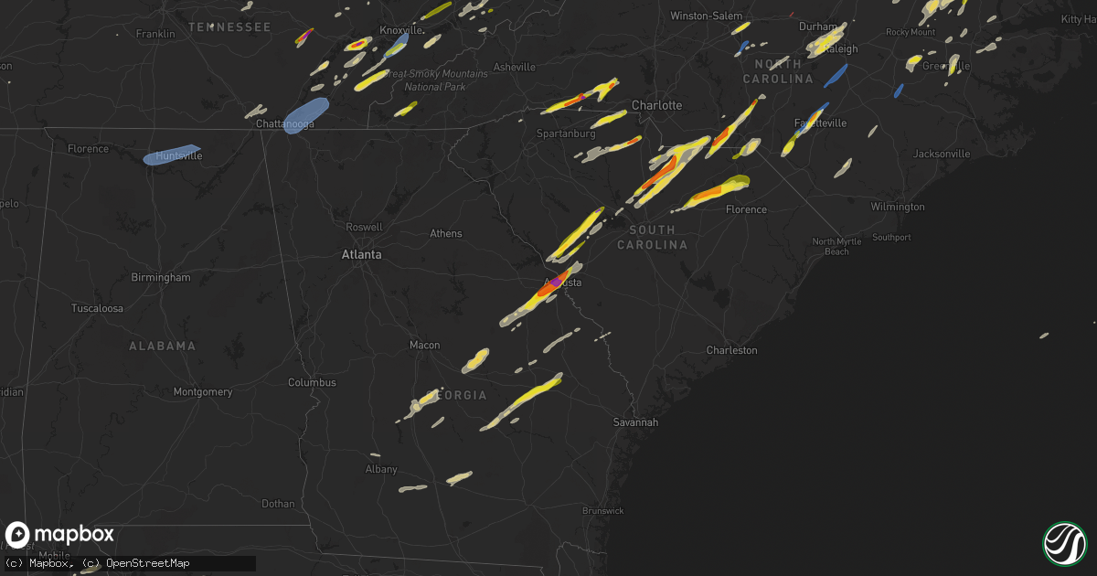
Hail Map on May 6, 2022
Get this storm
May 6 map
$229
one time, instant access
Download today. No call, no setup
Keep the $229
Bought the map and want the full workflow? Apply the entire $229 to a subscription within 7 days. None of it is wasted.
Every map, not just this one
This buys you this map. Subscription and you get every map we run, in the markets you choose from a few cities to whole states to nationwide. Plus real-time alerts the moment a storm fires.
Contact data
Name, contact info, occupancy, even credit band for addresses in the footprint. You go from where it hit to who to call.
Become the source they trust
Unlimited branding weather history reports on demand. You already have the documented answer ready for the property owner, and you are the one who showed up with it.
Property data and RoofTrace estimates
Pull up any address you have got, its value and the exact code rules for that jurisdiction, straight from One Click Code. Then RoofTrace estimates the squares, pitch, and roof value, priced the way you price.
States Impacted by Hail Map on May 6, 2022
Storm reports
South Carolina
| Date | Description |
|---|---|
| 05/06/20226:32 PM CDT | Lancaster assistant fire chief sent a picture of a tree down. Time estimated from radar. |
| 05/06/20225:53 PM CDT | On highway 9 in wallace |
| 05/06/20225:38 PM CDT | Several trees reported down between society hill and dovesville. |
| 05/06/20225:35 PM CDT | Fire department reported trees down on deerwood rd near doster rd. |
| 05/06/20225:34 PM CDT | Small tree blown down |
| 05/06/20225:32 PM CDT | Corrects previous tstm wnd dmg report from 2 ese buford. Lancaster assistant fire chief sent a picture of a tree down. Time estimated from radar. |
| 05/06/20225:27 PM CDT | Tree blown down across road at north 5th street and north center rd. |
| 05/06/20225:26 PM CDT | Power lines blown down along f street |
| 05/06/20225:25 PM CDT | Lee county dispatch reported a tree across a roadway on tram rd in lynchburg. Time estimated from radar. |
| 05/06/20225:23 PM CDT | A local report indicates 1.00 inch wind near 1 E HARTSVILLE |
| 05/06/20225:22 PM CDT | Highway patrol reported a tree in the roadway. Time estimated from radar. |
| 05/06/20225:20 PM CDT | Lee county dispatch reported a tree down near mayesville... Sc. Time estimated on radar. |
| 05/06/20225:20 PM CDT | Highway patrol reported a tree in the roadway. Time estimated from radar. |
| 05/06/20225:20 PM CDT | Tree blown across the road near the intersection of rainbow view rd. And kellybridge rd. |
| 05/06/20225:19 PM CDT | Tree on house in hartsville. Time estimated via radar. |
| 05/06/20225:19 PM CDT | Powerlines and 4 trees blown down at the intersection of west old camden rd. And ashland rd. |
| 05/06/20225:15 PM CDT | A local report indicates 1.00 inch wind near 3 S ROCK HILL |
| 05/06/20225:14 PM CDT | Fairfield county dot reports trees down on river road in fairfield county. Time estimated by radar. |
| 05/06/20225:12 PM CDT | A local report indicates 1.00 inch wind near 2 S CLYDE |
| 05/06/20225:11 PM CDT | Highway patrol reported a tree in the roadway. Time estimated from radar. |
| 05/06/20225:10 PM CDT | Corrects previous hail report from 7 n bishopville. Public reported through social media of half dollar size hail along kelly bridge road west in northern lee county. |
| 05/06/20225:07 PM CDT | Fairfield county dispatch reported a tree down along highway 321. Time estimated from radar. |
| 05/06/20225:06 PM CDT | Highway patrol reported a tree in the roadway. Time estimated from radar. |
| 05/06/20225:06 PM CDT | Fairfield county dispatch reported trees down on jenkinsville rd near sc 215. Time estimated on radar. |
| 05/06/20225:03 PM CDT | Highway patrol reported a tree in the roadway. Time estimated from radar. |
| 05/06/20225:03 PM CDT | Corrects previous tstm wnd dmg report from 4 wsw branchville. Corrects previous tstm wnd dmg report from 4 wsw branchville. Highway patrol reported a tree in the roadwa |
| 05/06/20225:02 PM CDT | Report of quarter sized hail northeast of kershaw... Sc at highway 903 and 601. Time estimated from radar. |
| 05/06/20225:01 PM CDT | Highway patrol reported tree in the road near the intersection of hwy. 76 and riser road. |
| 05/06/20224:59 PM CDT | Highway patrol reported a tree in the roadway. Time estimated from radar. |
| 05/06/20224:58 PM CDT | Quarter sized hail. Also 5 trees blown down in lowrys. |
| 05/06/20224:56 PM CDT | Colleton county 911 center reported a tree blown down along bells highway. Time was estimated from radar data. |
| 05/06/20224:51 PM CDT | Highway patrol reported a tree in the roadway. Time estimated from radar. |
| 05/06/20224:50 PM CDT | A local report indicates 1.75 inch wind near 2 NE MCCONNELLS |
| 05/06/20224:49 PM CDT | Tree reported down on i-26 at 172eb. Time estimated from radar. |
| 05/06/20224:49 PM CDT | The south carolina highway patrol reported a tree down on i-26 at exit 170 eastbound. Time estimated based on radar. |
| 05/06/20224:49 PM CDT | Public reported 2 inch diameter hail and small limbs down near prosperity... Sc. |
| 05/06/20224:48 PM CDT | Highway patrol reported the roadway blocked by tree along monticello road near i-20. |
| 05/06/20224:46 PM CDT | Lancaster county dispatch reported trees down aound zion rd and shiloh unity rd. Time estimated from radar. |
| 05/06/20224:46 PM CDT | Kershaw county dispatch reported a tree down along bishopville highway and lucknow rd. Time estimated from radar. |
| 05/06/20224:45 PM CDT | Highway patrol reported a tree blocking the roadway. Time estimated from radar. |
| 05/06/20224:44 PM CDT | Highway patrol reported tree in the roadway at the intersection of monticello road and dipsy do road. |
| 05/06/20224:43 PM CDT | Highway patrol reported tree down along i-26 near the 130 mile marker east bound lane. |
| 05/06/20224:43 PM CDT | Highway patrol reported roadway blocked by tree near the intersection of rawl road and clear springs trail. |
| 05/06/20224:40 PM CDT | Schp reports tree in roadway along i-26 eb at mile marker 160. |
| 05/06/20224:38 PM CDT | Highway patrol reported a tree in the roadway. Time estimated from radar. |
| 05/06/20224:37 PM CDT | Highway patrol reported a tree blocking the roadway. Time estimated from radar. |
| 05/06/20224:37 PM CDT | Department of highways reported a tree in the roadway. Time estimated from radar. |
| 05/06/20224:35 PM CDT | Highway patrol reported a tree in the roadway. Time estimated from radar. |
| 05/06/20224:35 PM CDT | Schp reports tree in roadway along i-26 eb at mile marker 143. |
| 05/06/20224:34 PM CDT | Highway patrol reported a tree in the roadway. Time estimated from radar. |
| 05/06/20224:33 PM CDT | Hail up to half dollar size fell causing leaf damage on the property. |
| 05/06/20224:32 PM CDT | Reported 1 inch hail near the town of ridgeway. |
| 05/06/20224:32 PM CDT | Sheriff dispatch reported lots of hail and numerous trees down across the county. |
| 05/06/20224:31 PM CDT | Sheriff dispatch reported quarter size hail near the town of saluda. |
| 05/06/20224:28 PM CDT | Highway patrol reported trees down near the intersection of hwy. 21 and fox paw court between rowesville and branchville. |
| 05/06/20224:25 PM CDT | Highway patrol reported a tree in the roadway. Time estimated from radar. |
| 05/06/20224:24 PM CDT | Several trees down...one fell on a house...one fell on power lines and one fell in the roadway. |
| 05/06/20224:22 PM CDT | Corrects previous tstm wnd dmg report from 4 wsw branchville. Highway patrol reported a tree in the roadway. Time estimated from radar. |
| 05/06/20224:18 PM CDT | Reported power lines down in the road along north street in the town of bamberg. |
| 05/06/20224:17 PM CDT | Schp reports tree in roadway near palomino rd and haven rd. |
| 05/06/20224:13 PM CDT | Roof damage to a structure. |
| 05/06/20224:13 PM CDT | Several trees knocked down on power lines. |
| 05/06/20224:11 PM CDT | Reported through social media of several large pines snapped off and one blocking the highway at the intersection of jones rd and hwy 283. Lots of wind debris. |
| 05/06/20224:07 PM CDT | Report from mping: quarter sized hail |
| 05/06/20224:06 PM CDT | Highway patrol reported a tree in the roadway. Time estimated from radar. |
| 05/06/20224:05 PM CDT | Public through social media reported trees blocking the roadway along blanchard road between ascauga lake road and old sudlow lake road. |
| 05/06/20224:02 PM CDT | Highway patrol reported a tree in the roadway. Time estimated from radar. |
| 05/06/20224:00 PM CDT | Highway patrol reported a tree in the roadway. Time estimated from radar. |
| 05/06/20224:00 PM CDT | Barnwell county dispatch reported widespread trees and powerlines down across the county. |
| 05/06/20224:00 PM CDT | Em reports multiple trees down on highway 64 in barnwell heading towards olar. |
| 05/06/20223:58 PM CDT | A location just east of north pacolet road had a brief period of hail at least the size of quarters. |
| 05/06/20223:58 PM CDT | Em reports multiple large trees down in the vicinity of robin rd and oriole st. One tree down on a house and another on a vehicle in a carport. |
| 05/06/20223:55 PM CDT | Trees reported down on sc-125 at appleton road. Time estimated from radar. |
| 05/06/20223:53 PM CDT | Public reports 1 inch diameter hail in belvedere. |
| 05/06/20223:53 PM CDT | Highway patrol reported trees down near the intersection of sc hwy. 421 and storm branch road. |
| 05/06/20223:52 PM CDT | Social media report of golf ball size hail near the intersection of hwy. 25 and i-20. |
| 05/06/20223:52 PM CDT | Allendale county 911 center reported multiple trees blown down in the martin area. Time was estimated from radar data. |
| 05/06/20223:50 PM CDT | Nickel to quarter sized hail reported on the glassy mountain side of gowensville. |
| 05/06/20223:45 PM CDT | Nearby county em sent picture of ping pong ball size hail from railroad avenue in north augusta. Time estimated. |
| 05/06/20223:16 PM CDT | Nws storm survey determined ef1 tornado touched down on hagood mill road. See pns for further information. |
| 05/06/20223:13 PM CDT | Trees down along porter rd near highway 178. |
| 05/06/20223:13 PM CDT | Corrects previous tstm wnd dmg report from 5 ene nine times. Roof damage to a structure. |
| 05/06/20223:13 PM CDT | Corrects previous tstm wnd dmg report from 4 nw pickens. Several trees knocked down on power lines. |
| 05/06/20223:12 PM CDT | Trees down. |
| 05/06/20221:53 AM CDT | At 653 PM EDT, severe thunderstorms were located along a line extending from Brittons Neck to near Dongola to Oatland, moving east at 60 mph. HAZARD...60 mph wind gusts and penny size hail. SOURCE...Radar indicated. IMPACT...Expect wind damage to trees and power lines. Locations impacted include... Myrtle Beach, Conway, North Myrtle Beach, Surfside Beach, Pawleys Island, Myrtle Beach Airport, Little River, Murrells Inlet, Little River Entrance, Socastee, Red Hill, Springmaid Pier, Garden City, North Myrtle Beach Airport, Cherry Grove Inlet, Horry, Loris, Johnsonville, Hemingway and Hickory Grove. |
| 05/06/20221:50 AM CDT | At 649 PM EDT, a severe thunderstorm was located near Sturdivants, or 15 miles southeast of Monroe, moving east at 55 mph. HAZARD...60 mph wind gusts and quarter size hail. SOURCE...Radar indicated. IMPACT...Hail damage to vehicles is expected. Expect wind damage to roofs, siding, and trees. Locations impacted include... Albemarle, Rockingham, Wadesboro, Hamlet, Ansonville, Hoffman, Polkton, Locust, Norwood and Badin. |
| 05/06/20221:25 AM CDT | At 625 PM EDT, a severe thunderstorm was located over Gourdin, or 16 miles south of Kingstree, moving east at 60 mph. HAZARD...60 mph wind gusts and penny size hail. SOURCE...Radar indicated. IMPACT...Expect wind damage to trees and power lines. Locations impacted include... Kingstree, Andrews, Hemingway, Rhems, Trio, Warsaw, Salters, Cades, Oatland, Nesmith, Indiantown, Gourdin, Plantersville, Outland, Yauhannah, Earle, Hebron, Morrisville, Henry and Lane. |
| 05/06/20221:13 AM CDT | At 612 PM EDT, severe thunderstorms were located along a line extending from Lake Wateree State Park to 6 miles northeast of Monticello, moving northeast at 45 mph. HAZARD...60 mph wind gusts and half dollar size hail. SOURCE...Radar indicated. IMPACT...Hail damage to vehicles is expected. Expect wind damage to trees and powerlines. Locations impacted include... Liberty Hill, Lake Wateree State Park, Blackstock, Lebanon Fire Station, Feasterville Fire Station, Bell Town Fire Station, White Oak, Mitford and Faith Christian School.This includes Interstate 77 between mile markers 41 and 50. |
| 05/06/20221:08 AM CDT | At 607 PM EDT, severe thunderstorms were located along a line extending from 4 miles west of Lincolnton to 5 miles south of Gastonia to 7 miles north of Chester, moving northeast at 35 mph. HAZARD...60 mph wind gusts and half dollar size hail. SOURCE...Radar indicated. IMPACT...Minor hail damage to vehicles is expected. Expect wind damage to trees and power lines. Locations impacted include... Gastonia, Rock Hill, Uptown Charlotte, Huntersville, Statesville, Lincolnton, York, Central Charlotte, South Charlotte and Northeast Charlotte. |
| 05/06/20221:06 AM CDT | At 606 PM EDT, a severe thunderstorm was located over Branchville, or 10 miles east of Bamberg, moving northeast at 45 mph. HAZARD...60 mph wind gusts and quarter size hail. SOURCE...Radar indicated. IMPACT...Hail damage to vehicles is expected. Expect wind damage to trees and powerlines. Locations impacted include... Bamberg, Branchville, Bowman, Rowesville and Yonder Field. This includes the following highways... Interstate 26 between mile markers 151 and 169. Interstate 95 between mile markers 85 and 86. |
| 05/06/20221:00 AM CDT | At 600 PM EDT, a severe thunderstorm was located near Bishopville, moving northeast at 45 mph. HAZARD...60 mph wind gusts and quarter size hail. SOURCE...Radar indicated. IMPACT...Minor hail damage to vehicles is possible. Expect wind damage to trees and power lines. Locations impacted include... Hartsville, Darlington, North Hartsville, Dovesville, Lydia, Auburn, Swift Creek, Clyde, Oats, Floyd, Kellytown, Darlington Raceway and Carolina Pines Regional Medical Center. |
| 05/06/202212:59 AM CDT | At 559 PM EDT, a severe thunderstorm was located 12 miles south of Monroe, or 6 miles northeast of Buford, moving east at 50 mph. HAZARD...60 mph wind gusts and quarter size hail. SOURCE...Radar indicated. IMPACT...Minor hail damage to vehicles is expected. Expect wind damage to trees and power lines. Locations impacted include... Sturdivants and Trinity. |
| 05/06/202212:59 AM CDT | At 559 PM EDT, severe thunderstorms were located along a line extending from 6 miles northeast of Prosperity to near Longtown, moving northeast at 45 mph. HAZARD...70 mph wind gusts and half dollar size hail. SOURCE...Radar indicated. IMPACT...Hail damage to vehicles is expected. Expect considerable tree damage. Wind damage is also likely to mobile homes, roofs, and outbuildings. Locations impacted include... Winnsboro, VC Summer Nuclear Station, Prosperity, Fairfield County Airport, Jenkinsville, Killian, Lake Carolina, Monticello, Longtown, Blair, Blythewood, Chapin, Ridgeway, Little Mountain, Pomaria, Peak, Lebanon Fire Station, US-176 and SC- 34 Crossroads, White Rock and Rion.This includes the following highways... Interstate 26 between mile markers 77 and 98. Interstate 77 between mile markers 22 and 41. |
| 05/06/202212:56 AM CDT | At 556 PM EDT, a severe thunderstorm was located near Summerton, or 14 miles west of Manning, moving northeast at 70 mph. HAZARD...60 mph wind gusts and quarter size hail. SOURCE...Radar indicated. IMPACT...Hail damage to vehicles is expected. Expect wind damage to trees and powerlines. Locations impacted include... Sumter, Manning, South Sumter, Shaw Air Base, Holly Hill, Summerton, Eastover, Elloree, Santee State Park, Mulberry, Alcolu, Woods Bay State Park, Santee Cooper Regional Airport, Elliott, Sumter County Airport, Millwood, Poinsett State Park, Oakland, Santee and Turbeville.This includes Interstate 95 between mile markers 89 and 146. |
| 05/06/202212:54 AM CDT | At 553 PM EDT, a severe thunderstorm was located near Bishopville, moving northeast at 50 mph. HAZARD...60 mph wind gusts and quarter size hail. SOURCE...Radar indicated. IMPACT...Hail damage to vehicles is expected. Expect wind damage to trees and powerlines. Locations impacted include... Bishopville, Lucknow and Ashland. This includes Interstate 20 in South Carolina between mile markers114 and 116. |
| 05/06/202212:46 AM CDT | At 545 PM EDT, a severe thunderstorm was located over Rivers Bridge State Park, or 12 miles north of Hampton, moving northeast at 70 mph. HAZARD...60 mph wind gusts and quarter size hail. SOURCE...Radar indicated. IMPACT...Hail damage to vehicles is expected. Expect wind damage to trees and powerlines. Locations impacted include... Bamberg, Denmark, Rivers Bridge State Park, Ehrhardt, Olar, Kline, Govan and Bamberg County Airport. |
| 05/06/202212:44 AM CDT | At 544 PM EDT, severe thunderstorms were located along a line extending from 7 miles east of Bowman to near Reevesville, moving east at 50 mph. HAZARD...60 mph wind gusts and nickel size hail. SOURCE...Radar indicated. IMPACT...Expect damage to trees and powerlines. Locations impacted include: Moncks Corner, Saint George, Dorchester, Ridgeville, Saint Stephen, Harleyville, Bonneau, Reevesville, Cross, Northern Lake Moultrie, Jedburg, Old Santee Canal State Park, Eastern Lake Marion, Pinopolis and Southern Lake Moultrie.This warning includes the following interstates: I-26 between mile markers 171 and 198. I-95 in South Carolina between mile markers 70 and 85. |
| 05/06/202212:41 AM CDT | At 541 PM EDT, severe thunderstorms were located along a line extending from near Ulmer to near Crocketville to near Grays, moving northeast at 65 mph. HAZARD...60 mph wind gusts. SOURCE...Radar indicated. IMPACT...Expect damage to trees and powerlines. Locations impacted include: Walterboro, Allendale, Hampton, Lake Warren State Park, Colleton, Varnville, Estill, Fairfax, Cottageville, Brunson, Gifford, Furman, Sycamore, Luray and Smoaks.This warning includes I-95 in South Carolina between mile markers 49and 69. |
| 05/06/202212:37 AM CDT | At 536 PM EDT, severe thunderstorms were located along a line extending from 8 miles southwest of Prosperity to Red Bank, moving northeast at 50 mph. HAZARD...70 mph wind gusts and half dollar size hail. SOURCE...Radar indicated. IMPACT...Hail damage to vehicles is expected. Expect considerable tree damage. Wind damage is also likely to mobile homes, roofs, and outbuildings. Locations impacted include... Columbia, Lexington, West Columbia, Cayce, Irmo, Newberry, Batesburg-Leesville, Springdale, St. Andrews, VC Summer Nuclear Station, Oak Grove, Highway 6 at Lake Murray Dam, Red Bank, Dentsville, South Congaree, Pine Ridge, Prosperity, Columbia International University, Jenkinsville and Harbison State Forest.This includes the following highways... Interstate 126 between mile markers 0 and 3. Interstate 20 in South Carolina between mile markers 42 and 72. Interstate 26 between mile markers 70 and 114. Interstate 77 between mile markers 20 and 22. |
| 05/06/202212:32 AM CDT | At 531 PM EDT, a severe thunderstorm was located near Longtown, or 9 miles east of Winnsboro, moving northeast at 70 mph. HAZARD...Ping pong ball size hail and 60 mph wind gusts. SOURCE...Radar indicated. IMPACT...People and animals outdoors will be injured. Expect hail damage to roofs, siding, windows, and vehicles. Expect wind damage to trees and powerlines. Locations impacted include... Winnsboro, Lake Wateree Dam, Kershaw, Heath Springs, Westville, Longtown, Liberty Hill, Lake Wateree State Park, Blythewood, Ridgeway, Winnsboro Mills, Smallwood and Lake Wateree near Highway 97.This includes Interstate 77 between mile markers 31 and 42. |
| 05/06/202212:26 AM CDT | At 526 PM EDT, severe thunderstorms were located along a line extending from near Westville to 6 miles south of Lugoff, moving northeast at 45 mph. HAZARD...60 mph wind gusts and quarter size hail. SOURCE...Radar indicated. IMPACT...Hail damage to vehicles is expected. Expect wind damage to trees and powerlines. Locations impacted include... Camden, Bishopville, Chesterfield, Lugoff, Carolina Sandhills Wildlife Refuge, Westville, Cassatt, Goodale State Park, Mcbee, Bethune, Lucknow, North Central High School, Dekalb, Alligator Fire Station, Middendorf, North Towne Square Shopping Center, Bay Springs Fire Station, Antioch, Midway Elementary School and Chesterfield Detention Center.This includes Interstate 20 in South Carolina between mile markers 91and 112. |
| 05/06/202212:25 AM CDT | At 524 PM EDT, a severe thunderstorm was located near Edisto Gardens, or near Orangeburg, moving northeast at 70 mph. HAZARD...70 mph wind gusts and half dollar size hail. SOURCE...Radar indicated. IMPACT...Hail damage to vehicles is expected. Expect considerable tree damage. Wind damage is also likely to mobile homes, roofs, and outbuildings. Locations impacted include... Orangeburg, Bamberg, Denmark, McEntire Air Base, Brookdale, St. Matthews, Holly Hill, Branchville, Summerton, Bowman, Eastover, Elloree, Santee State Park, Orangeburg County Airport, Congaree National Park, Claflin College, South Carolina State University, Sandy Run, Gadsden and Edisto Gardens.This includes the following highways... Interstate 26 between mile markers 124 and 169. Interstate 95 between mile markers 85 and 109. |
| 05/06/202212:13 AM CDT | At 512 PM EDT, a severe thunderstorm was located 13 miles west of Union, or 10 miles west of Buffalo, moving northeast at 35 mph. HAZARD...60 mph wind gusts and quarter size hail. SOURCE...Radar indicated. IMPACT...Minor hail damage to vehicles is expected. Expect wind damage to trees and power lines. Locations impacted include... Union, Monarch Mill, Buffalo, Jonesville, Lockhart, Cross Keys, Saratt, Cross Anchor, Adamsburg and Bullock Creek. |
| 05/06/202212:10 AM CDT | At 509 PM EDT, severe thunderstorms were located along a line extending from Johnston to near Aiken State Park, moving northeast at 70 mph. HAZARD...70 mph wind gusts and half dollar size hail. SOURCE...Radar indicated. IMPACT...Hail damage to vehicles is expected. Expect considerable tree damage. Wind damage is also likely to mobile homes, roofs, and outbuildings. Locations impacted include... Aiken, North Augusta, Batesburg-Leesville, Aiken Mall, Belvedere, Clearwater, Edgefield, Saluda, Johnston, Ridge Spring, Clarks Hill Recreation Area, Edgefield County Airport, Hamilton Branch State Park, Citizens Park, USC Aiken, Saluda County Airport, J. Strom Thurmond Dam, Aiken Municipal Airport, Gloverville and Graniteville.This includes the following highways... Interstate 20 in South Carolina between mile markers 1 and 44. Interstate 520 in South Carolina between mile markers 20 and 23. |
| 05/06/202212:04 AM CDT | At 504 PM EDT, a severe thunderstorm was located 8 miles southeast of Columbus, or 5 miles north of Lake Bowen, moving east at 45 mph. HAZARD...60 mph wind gusts and quarter size hail. SOURCE...Radar indicated. IMPACT...Minor hail damage to vehicles is expected. Expect wind damage to trees and power lines. Locations impacted include... Shelby, Boiling Springs NC, Landrum, Chesnee, Patterson Springs, Campobello, Ellenboro, Lattimore, Mooresboro and Earl. |
| 05/06/202212:00 AM CDT | At 459 PM EDT, a severe thunderstorm was located over Appling, or 10 miles northwest of Grovetown, moving northeast at 40 mph. HAZARD...70 mph wind gusts and quarter size hail. SOURCE...Radar indicated. IMPACT...Hail damage to vehicles is expected. Expect considerable tree damage. Wind damage is also likely to mobile homes, roofs, and outbuildings. Locations impacted include... Thomson, Appling, Riverwood, Mistletoe State Park, Thomson-McDuffie County Airport, Wrightsboro, Dearing, Sweetwater Park, Winfield, McDuffie County Fire Department, Thomson Fire Department, McDuffie Regional Medical Center, Knox Scout Reservation, White Oak Campground, Boneville, Double Branches, Columbia County Jail, Wildwood Park, Ansley Mill and Eubank-Blanchard Community Center.This includes Interstate 20 in Georgia between mile markers 167 and184. |
| 05/05/202211:57 PM CDT | At 457 PM EDT, a severe thunderstorm was located near Barnwell, moving northeast at 60 mph. HAZARD...60 mph wind gusts and quarter size hail. SOURCE...Radar indicated. IMPACT...Hail damage to vehicles is expected. Expect wind damage to trees and powerlines. Locations impacted include... Barnwell, Bamberg, Denmark, Williston, Blackville, New Ellenton, Branchville, Barnwell State Park, Rivers Bridge State Park, Ehrhardt, Springfield, Hilda, Salley, Neeses, Norway, Rowesville, Snelling, Olar, Perry and Kline. |
| 05/05/202211:40 PM CDT | At 440 PM EDT, a severe thunderstorm was located over Augusta Mall, or near Fort Gordon, moving northeast at 65 mph. HAZARD...Ping pong ball size hail and 60 mph wind gusts. SOURCE...Radar indicated. IMPACT...People and animals outdoors will be injured. Expect hail damage to roofs, siding, windows, and vehicles. Expect wind damage to trees and powerlines. Locations impacted include... Aiken, North Augusta, Grovetown, Evans, Martinez, Aiken Mall, Fort Gordon, Augusta, Clearwater, Belvedere, Edgefield, Hephzibah, Johnston, Glendale, South Augusta, Edgefield County Airport, Midtown, Riverwood, Summerville and Augusta Mall.This includes the following highways... Interstate 20 in Georgia between mile markers 186 and 201. Interstate 20 in South Carolina between mile markers 0 and 27. Interstate 520 in Georgia between mile markers 1 and 15. Interstate 520 in South Carolina between mile markers 16 and 23. |
| 05/05/202211:32 PM CDT | At 431 PM EDT, a severe thunderstorm was located 15 miles northwest of Greenville Downtown, or near Slater-Marietta, moving east at 40 mph. HAZARD...60 mph wind gusts and quarter size hail. SOURCE...Radar indicated. IMPACT...Minor hail damage to vehicles is expected. Expect wind damage to trees and power lines. Locations impacted include... Landrum, Slater-Marietta, Inman, Campobello, Tigerville, Lake Bowen, Lake Robinson, Pleasant Ridge State Park, Jones Gap State Park and Caesars Head State Park. |
| 05/05/202211:22 PM CDT | At 421 PM EDT, a severe thunderstorm was located near Wrens, or 14 miles southwest of Grovetown, moving northeast at 55 mph. HAZARD...60 mph wind gusts and quarter size hail. SOURCE...Radar indicated. IMPACT...Hail damage to vehicles is expected. Expect wind damage to trees and powerlines. Locations impacted include... Grovetown, Evans, Martinez, Fort Gordon, Augusta, Hephzibah, Harlem, Glendale, Gough, South Augusta, Midtown, Summerville, Augusta Mall, Daniel Field, Augusta Regional Airport, Village Plaza Shopping Center, Augusta National Golf Club, McBean, Blythe and Dearing.This includes the following highways... Interstate 20 in Georgia between mile markers 185 and 201. Interstate 520 in Georgia between mile markers 1 and 15. |
| 05/05/202211:06 PM CDT | At 405 PM EDT, a severe thunderstorm was located 9 miles west of Pickens, or near Keowee Toxaway State Park, moving east at 40 mph. HAZARD...60 mph wind gusts and penny size hail. SOURCE...Radar indicated. IMPACT...Expect damage to trees and power lines. Locations impacted include... Pickens, Slater-Marietta, Lake Keowee, Pleasant Ridge State Park, Jocassee Gorges, Lake Jocassee, Devils Fork State Park, Keowee Toxaway State Park, Table Rock State Park and Pumpkintown. |
| 05/05/20228:39 PM CDT | At 138 PM EDT, a severe thunderstorm was located 4 miles west of Rock Hill, or near Newport, moving northeast at 55 mph. HAZARD...60 mph wind gusts and quarter size hail. SOURCE...Radar indicated. IMPACT...Minor hail damage to vehicles is expected. Expect wind damage to trees and power lines. Locations impacted include... Rock Hill, Uptown Charlotte, Central Charlotte, Northeast Charlotte, Southwest Charlotte, East Charlotte, Northwest Charlotte, Mt Holly, Fort Mill and Belmont. |
| 05/05/20228:02 PM CDT | At 102 PM EDT, a severe thunderstorm was located 9 miles west of Shelby, or near Boiling Springs NC, moving northeast at 50 mph. HAZARD...60 mph wind gusts and quarter size hail. SOURCE...Radar indicated. IMPACT...Minor hail damage to vehicles is expected. Expect wind damage to trees and power lines. Locations impacted include... Shelby, Boiling Springs NC, Belwood, Lawndale, Fallston, Polkville, Ellenboro, Lattimore, Mooresboro and Waco. |
West Virginia
| Date | Description |
|---|---|
| 05/06/20224:42 PM CDT | Corrects previous tstm wnd dmg report from hode. Trees down onto powerlines. |
| 05/06/202212:15 PM CDT | Several trees and power lines down in the quinwood area. |
| 05/06/202212:10 PM CDT | A porch on a home was damaged including a fuse box attached to the porch. One vehicle damaged with a broken window from a downed tree branch. |
| 05/06/202211:10 AM CDT | Facebook video shows a large swath of tree damage near adolph. Many large trees snapped or uprooted laying in one direction going up the mountain... Indicating straight |
| 05/06/20225:25 AM CDT | At 1025 AM EDT, a severe thunderstorm was located near Arnoldsburg, or 7 miles southeast of Spencer, moving east at 35 mph. HAZARD...60 mph wind gusts and quarter size hail. SOURCE...Radar indicated. IMPACT...Hail damage to vehicles is expected. Expect wind damage to roofs, siding, and trees. Locations impacted include... Spencer, Grantsville, Arnoldsburg, Big Otter, Cedar Creek State Park, Wallback, Amma, Nebo, Shock, Millstone, Rosedale, Mount Zion, Left Hand, Stumptown, Tanner, Frametown, Strange Creek, Wilsie, Tariff and Servia.This includes Interstate 79 between mile markers 22 and 55. |
| 05/06/20222:25 AM CDT | At 725 PM EDT, severe thunderstorms were located along a line extending from near Natural Well to Oriskany, moving northeast at 55 mph. HAZARD...60 mph wind gusts. SOURCE...Radar indicated. IMPACT...Expect damage to roofs, siding, and trees. Locations impacted include... Covington... Clifton Forge... Buchanan... Eagle Rock... Oriskany... Iron Gate... and Fincastle. |
Georgia
| Date | Description |
|---|---|
| 05/06/20225:30 PM CDT | Public caller reports of tree down from thunderstorm winds near pine st / nichols st. One lane blocked. |
| 05/06/20224:52 PM CDT | Trees and power lines down in the valdosta area. |
| 05/06/20224:32 PM CDT | Trees and power lines down across the northern portions of lowndes county. |
| 05/06/20224:22 PM CDT | Multiple trees down along upper and lower river rd in hartford |
| 05/06/20223:55 PM CDT | Report from mping: ping pong ball sized hail |
| 05/06/20223:47 PM CDT | Public reported through social media of egg size hail neaer the university hospital and wrightsboro road. |
| 05/06/20223:47 PM CDT | Reported quarter size hail at augusta university. |
| 05/06/20223:46 PM CDT | Reported golf ball size hail along summer ridge drive in augusta. |
| 05/06/20223:45 PM CDT | Golf ball sized hail and 50 mph wind gusts reported near augusta national golf course. |
| 05/06/20223:45 PM CDT | Public reported through social media of large hail that ranged from 1 inch up to just over 2 inches along pennsylvania avenue near clifton street. |
| 05/06/20223:45 PM CDT | Reported a large tree down across river north driver in north augusta. |
| 05/06/20223:44 PM CDT | Reported golf ball size hail at daniel field. |
| 05/06/20223:43 PM CDT | Report from media of hail just larger than 2 inches at the first baptist church at wheeler road and jackson road. |
| 05/06/20223:41 PM CDT | Reported half dollar size hail at fort gordon. |
| 05/06/20223:36 PM CDT | Reported trees down at the intersection of horizon south pkwy. And gateway blvd. |
| 05/06/20223:36 PM CDT | City of grovetown reports trees and power lines down in several areas of the city. Some impacted locations include railroad ave.... Harlem grovetown rd in the area of f |
| 05/06/20223:27 PM CDT | Public reported numerous trees and power lines down on hwy 221. |
| 05/06/20223:27 PM CDT | Burke county dispatch reported widespread trees and powerlines down across the county. Time estimated on radar. |
| 05/06/20223:24 PM CDT | Several trees down on hwy 221 n near the jefferson/mcduffie county line. |
| 05/06/20223:19 PM CDT | Multiple trees reported down along hwy 221 n between airport rd and ellis cemetary rd. |
| 05/06/20223:18 PM CDT | Screven county warning point reported trees down along scarboro highway. Time estimated from radar. |
| 05/06/20223:15 PM CDT | Tree down on caylor rd. |
| 05/06/20223:03 PM CDT | A few trees... Along with powerlines... Reported down near the intersection of hwy 56 n and hwy 192 n |
| 05/06/20223:01 PM CDT | Tree down at the intersection of huckleberry rd and oak grove church rd. |
| 05/06/20223:00 PM CDT | Candler county sheriff reported quarter sized hail along route 23 about 3 miles north of metter. |
| 05/06/20223:00 PM CDT | A large tree fell across graysville road and downed power lines as well. |
| 05/06/20223:00 PM CDT | A tree was downed across highway 41 near three notch road. |
| 05/06/20222:58 PM CDT | Tree reported down on a home on the 200 block of n central st in swainsboro. |
| 05/06/20222:58 PM CDT | Multiple trees and powerlines down in the town of davisboro |
| 05/06/20222:56 PM CDT | Law enforcement relayed a photo of ping pong ball sized hail which fell along olifftown road. Time was estimated from radar data. |
| 05/06/20222:53 PM CDT | Emergency manager relayed report of trees down along olifftown road. Time estimated from radar. |
| 05/06/20222:53 PM CDT | Candler county sheriff reported quarter sized hail along route 23 about 3 miles north of metter. Corrected time of event based on radar data. |
| 05/06/20222:45 PM CDT | Tree down in woods. |
| 05/06/20222:40 PM CDT | Roof removed from a manufactured home on ralph young rd. |
| 05/06/20222:39 PM CDT | Emergency manager relayed report of powerlines down along macwac lake road. Time estimated from radar. |
| 05/06/20222:38 PM CDT | Golf ball sized hail at the intersection of watermelon rd and hwy 157. |
| 05/06/20222:36 PM CDT | Tree reported down on hwy 29 near the intersection of brick mill rd. |
| 05/06/20222:36 PM CDT | A large tree was downed across arnold road in rock spring. |
| 05/06/20222:36 PM CDT | Roof removed from a manufactued home on the 100 block of columbia st. |
| 05/06/20222:31 PM CDT | Tree down along the 900 block of pope creek rd |
| 05/06/20222:30 PM CDT | Tree down near the intersection of hwy 199 and mercer creek rd. |
| 05/06/20222:30 PM CDT | Tree down on nobles rd. |
| 05/06/20222:30 PM CDT | Tree down on powerlines on prospect church rd. |
| 05/06/20222:27 PM CDT | Several trees were downed on and near lookout mountain... Including on scenic hwy... Wooten drive... Phillips lane... Creek rd... And sarah chapel rd. |
| 05/06/20222:25 PM CDT | Several trees were downed in trenton including on wren ave... Poplar st... Bond ave... And jeffery town road. |
| 05/06/20222:24 PM CDT | Tree down along the 900 block of byrds chapel rd. |
| 05/06/20222:23 PM CDT | Trees were downed west of trenton including on mcbryar rd... Worley chapel rd... Ga-301... And owenby filler rd. |
| 05/06/20222:18 PM CDT | Half-dollar sized hail reported in kibbee... Ga. |
| 05/06/20222:13 PM CDT | Tree and powerlines down near intersection of klondike rd and barrett rd |
| 05/06/20222:13 PM CDT | Tree and powerlines down near intersection of bear branch rd and ivory dr |
| 05/06/20222:07 PM CDT | Multiple trees reported down on macedonia church rd. |
| 05/06/20222:07 PM CDT | Mutliple large trees down around property off of antioch road... North of cochran. |
| 05/06/20222:06 PM CDT | Tree down across road on ga-247 near waste treatment plant. |
| 05/06/20221:55 PM CDT | Roof damage at rebels rd and bobby rd |
| 05/06/20221:50 PM CDT | Multiple trees down near the intersection of county line rd and poke rd |
| 05/06/20221:50 PM CDT | Corrects time of previous tstm wnd dmg report from 1 ene norman park. Tree on car at serena dr. |
| 05/06/20221:50 PM CDT | Tree down on power lines. |
| 05/06/20221:50 PM CDT | Multiple trees reported down near intersection of ga-26 and loggins rd |
| 05/06/20221:45 PM CDT | Tree down at north hwy 125 at vanceville. |
| 05/06/20221:45 PM CDT | Powerline down at harris st and hwy 82. |
| 05/06/20221:45 PM CDT | Roof peeled off structure near intersection of langford rd and everett rd. |
| 05/06/20221:45 PM CDT | Tree reported down on poplar st near intersection with 3rd ave. |
| 05/06/20221:45 PM CDT | Tree reported down on sweet gum rd. |
| 05/06/20221:45 PM CDT | Tree and powerlines down at 255 whitley rd. |
| 05/06/20221:38 PM CDT | Tree down near the intersection of ga-112 and christian hill rd |
| 05/06/20221:35 PM CDT | Tree on car at serena dr. |
| 05/06/20221:35 PM CDT | Trees at sr37 west and summerlin road down tree on vehicle in norman park. |
| 05/06/20221:34 PM CDT | Tree reported down on bowen rd near the intersection with calhoun rd. |
| 05/06/20221:30 PM CDT | A local report indicates 1.00 inch wind near 5 SE HOLT |
| 05/06/20221:30 PM CDT | Tree down on althea rd between begonia and plum. |
| 05/06/20221:30 PM CDT | Tree down on pansey rd. |
| 05/06/20221:30 PM CDT | Tree down at satilla church rd near lotus rd. |
| 05/06/202212:40 PM CDT | Tree down blocking pleasant hill road. |
| 05/06/20223:46 AM CDT | At 845 PM EDT, severe thunderstorms were located along a line extending from near Taylor to near Lulu, moving east at 25 mph. HAZARD...60 mph wind gusts and penny size hail. SOURCE...Radar indicated. IMPACT...Expect damage to roofs, siding, and trees. Locations impacted include... Lake Butler, Taylor, Glen St. Mary, Palestine Community, Lulu, Olustee, Sanderson and Johnstown. |
| 05/06/20221:58 AM CDT | At 657 PM EDT, a severe thunderstorm was located 10 miles northeast of Jasper, moving east at 30 mph. HAZARD...60 mph wind gusts and penny size hail. SOURCE...Radar indicated. IMPACT...Expect damage to roofs, siding, and trees. Locations impacted include... Needmore. |
| 05/06/202212:17 AM CDT | At 517 PM EDT, a severe thunderstorm was located near Hawkinsville, moving east at 30 mph. HAZARD...60 mph wind gusts and quarter size hail. SOURCE...Radar indicated. IMPACT...Hail damage to vehicles is expected. Expect wind damage to roofs, siding, and trees. Locations impacted include... Cochran, Hawkinsville, Dubois, Gresston, Empire, Mobley Crossing, Hartford, Roddy, Pulaski State Prison, Baileys Park and Browndale. |
| 05/05/202211:49 PM CDT | At 448 PM EDT, a severe thunderstorm was located near Burtons Ferry Landing, moving northeast at 65 mph. HAZARD...60 mph wind gusts and quarter size hail. SOURCE...Radar indicated. IMPACT...Minor hail damage to vehicles is possible. Expect wind damage to trees and powerlines. Locations impacted include: Allendale, Hampton, Lake Warren State Park, Fairfax, Brunson, Gifford, Sycamore, Luray, Ulmer, Crocketville, Seigling, Martin, Miley, Barton and Millett. |
| 05/05/202211:28 PM CDT | At 427 PM EDT, a severe thunderstorm was located over Alexander, or 10 miles southwest of Plant Vogtle, moving northeast at 65 mph. HAZARD...60 mph wind gusts and quarter size hail. SOURCE...Radar indicated. IMPACT...Hail damage to vehicles is expected. Expect wind damage to trees and powerlines. Locations impacted include... Waynesboro, Barnwell, Savannah River Site, Plant Vogtle, Sardis, Alexander, Burke County Airport, Snelling, Kline, Girard, Di- Lane Wildlife Management Area, Savannah River Site H Canyon, Savannah River Site K Complex and Shell Bluff. |
| 05/05/202211:16 PM CDT | At 415 PM EDT, a severe thunderstorm was located over Scarboro, moving northeast at 50 mph. HAZARD...60 mph wind gusts and quarter size hail. SOURCE...Radar indicated. IMPACT...Minor hail damage to vehicles is possible. Expect wind damage to trees and powerlines. Locations impacted include: Millen, Sylvania, Butts, Hiltonia, Newington, Oliver, Rocky Ford, Altman, Perkins, Dover, Emmalane, Millhaven, Scarboro, Woodcliff and Hilltonia. |
| 05/05/202211:03 PM CDT | At 402 PM EDT, a severe thunderstorm was located over Midville, or 14 miles north of Swainsboro, moving northeast at 55 mph. HAZARD...60 mph wind gusts and quarter size hail. SOURCE...Radar indicated. IMPACT...Hail damage to vehicles is expected. Expect wind damage to trees and powerlines. Locations impacted include... Waynesboro, Sardis, Midville, Alexander, Gough, Burke County Airport, Keysville, Vidette, Di- Lane Wildlife Management Area, Magruder and Rosier. |
| 05/05/202211:00 PM CDT | At 400 PM EDT, severe thunderstorms were located along a line extending from near Agricola to near Twin City, moving northeast at 65 mph. HAZARD...60 mph wind gusts and quarter size hail. SOURCE...Radar indicated. IMPACT...Hail damage to vehicles is expected. Expect wind damage to roofs, siding, and trees. Locations impacted include... Louisville, Wrens, Wadley, Stapleton, Avera, Garfield, Summertown, Canoochee, Grange, Stapletons Crossroads, Matthews, Three Points, Moxley, Stellaville and Colemans Lake. |
| 05/05/202210:37 PM CDT | At 337 PM EDT, severe thunderstorms were located along a line extending from near Oconee to near Zaidee, moving northeast at 55 mph. HAZARD...60 mph wind gusts and quarter size hail. SOURCE...Radar indicated. IMPACT...Hail damage to vehicles is expected. Expect wind damage to roofs, siding, and trees. Locations impacted include... Swainsboro, Sandersville, Wrightsville, Wadley, Davisboro, Tennille, Adrian, Harrison, Bartow, Oconee, Summertown, Riddleville, Kite, Spann, Downs, Covena, Modoc, Norristown, Pringle and Dellwood. |
| 05/05/202210:35 PM CDT | At 334 PM EDT, a severe thunderstorm was located near Oak Park, moving northeast at 45 mph. HAZARD...60 mph wind gusts and quarter size hail. SOURCE...Radar indicated. IMPACT...Minor hail damage to vehicles is possible. Expect wind damage to trees and powerlines. Locations impacted include: Statesboro, Metter, Brooklet, Portal, Cobbtown, Pulaski, Register, Aline, Georgia Southern and Hopeulikit.This warning includes I-16 between mile markers 96 and 114. |
| 05/05/202210:30 PM CDT | At 330 PM EDT, a severe thunderstorm was located over Normantown, or 8 miles north of Lyons, moving northeast at 40 mph. HAZARD...60 mph wind gusts and quarter size hail. SOURCE...Radar indicated. IMPACT...Hail damage to vehicles is expected. Expect wind damage to roofs, siding, and trees. Locations impacted include... Lyons, Vidalia, Stillmore, Oak Park and Normantown. |
| 05/05/202210:24 PM CDT | At 323 PM EDT, a severe thunderstorm was located near Pridgen, or 7 miles north of Ambrose, moving northeast at 40 mph. HAZARD...60 mph wind gusts. SOURCE...Radar indicated. IMPACT...Expect damage to roofs, siding, and trees. Locations impacted include... Pridgen. |
| 05/05/202210:13 PM CDT | At 313 PM EDT, a severe thunderstorm was located over Danville, or 8 miles southeast of Jeffersonville, moving northeast at 60 mph. HAZARD...60 mph wind gusts and quarter size hail. SOURCE...Radar indicated. IMPACT...Hail damage to vehicles is expected. Expect wind damage to roofs, siding, and trees. Locations impacted include... Jeffersonville, Irwinton, McIntyre, Dudley, Toomsboro, Danville, Montrose, Allentown, Chappells Mill, Nicklesville and Ripley. |
| 05/05/202210:09 PM CDT | At 309 PM EDT, a severe thunderstorm was located over Cadwell, or 14 miles northeast of Eastman, moving northeast at 60 mph. HAZARD...60 mph wind gusts and quarter size hail. SOURCE...Radar indicated. IMPACT...Hail damage to vehicles is expected. Expect wind damage to roofs, siding, and trees. Locations impacted include... Dublin, Soperton, East Dublin, Dexter, Dudley, Cadwell, Rentz, Lothair, Cedar Grove, Orland, Rockledge, Orianna, Minter, Lovett, Harlow, Brewton, Lowery and Tuckers Crossroad. |
| 05/05/202210:06 PM CDT | At 306 PM EDT, a severe thunderstorm was located over Mount Vernon, moving northeast at 40 mph. HAZARD...60 mph wind gusts and quarter size hail. SOURCE...Radar indicated. IMPACT...Hail damage to vehicles is expected. Expect wind damage to roofs, siding, and trees. Locations impacted include... Mount Vernon, Vidalia, Ailey, Higgston, Tarrytown and Kibbee. |
| 05/05/202210:03 PM CDT | At 302 PM EDT, a severe thunderstorm was located 7 miles northeast of Alapaha, or 9 miles southeast of Ocilla, moving northeast at 45 mph. HAZARD...60 mph wind gusts and nickel size hail. SOURCE...Radar indicated. IMPACT...Expect damage to roofs, siding, and trees. Locations impacted include... Douglas, Broxton, Ambrose, Pridgen and West Green. |
| 05/05/20229:58 PM CDT | At 257 PM EDT, a severe thunderstorm was located 7 miles south of Greensboro, or 12 miles southwest of Quincy, moving northeast at 25 mph. HAZARD...60 mph wind gusts and quarter size hail. SOURCE...Radar indicated. IMPACT...Hail damage to vehicles is expected. Expect wind damage to roofs, siding, and trees. Locations impacted include... Quincy, Midway, Havana, Greensboro, Gretna, Freemont, Lake Talquin, Littman, Juniper, Douglas City, Florence, Hosford, Scotland, Jamieson, Fort Braden, Santa Clara, Shady Rest, Quincy Airport, Lowry and Wetumpka. |
| 05/05/20229:51 PM CDT | At 251 PM EDT, a severe thunderstorm was located over Klondike, or 7 miles northwest of Hawkinsville, moving northeast at 45 mph. HAZARD...70 mph wind gusts and quarter size hail. SOURCE...Radar indicated. IMPACT...Hail damage to vehicles is expected. Expect considerable tree damage. Wind damage is also likely to mobile homes, roofs, and outbuildings. Locations impacted include... Cochran, Hawkinsville, Marion, Hayneville, Browndale, Tarversville, Mobley Crossing, Baileys Park, Royal, District Path, Ocmulgee Public Fishing Area, Paulk, Goldsboro, Cary, Pulaski State Prison, Porter, Kathleen, Coley Station, Sand Bed and Bullard. |
| 05/05/20229:48 PM CDT | At 248 PM EDT, a severe thunderstorm was located over Enigma, or 11 miles east of Tifton, moving northeast at 40 mph. HAZARD...60 mph wind gusts and quarter size hail. SOURCE...Radar indicated. IMPACT...Hail damage to vehicles is expected. Expect wind damage to roofs, siding, and trees. Locations impacted include... Tifton, Enigma, Alapaha, Vanceville, Gladys, Glory, Wray and Brookfield. |
| 05/05/20229:48 PM CDT | At 247 PM EDT, a severe thunderstorm was located over Ocmulgee Banks, or 9 miles north of Abbeville, moving northeast at 45 mph. HAZARD...60 mph wind gusts and quarter size hail. SOURCE...Radar indicated. IMPACT...Hail damage to vehicles is expected. Expect wind damage to roofs, siding, and trees. Locations impacted include... Eastman, Chester, Union, Dubois, Gresston, Plainfield, Empire, Yonkers, Cedar Creek, Roddy, Rowland, Ocmulgee Banks and Godwinsville. |
| 05/05/20229:40 PM CDT | At 240 PM EDT, a severe thunderstorm was located near Scotland, or near McRae, moving northeast at 35 mph. HAZARD...60 mph wind gusts and quarter size hail. SOURCE...Radar indicated. IMPACT...Hail damage to vehicles is expected. Expect wind damage to roofs, siding, and trees. Locations impacted include... McRae, Alamo, Glenwood, Scotland, Towns, Spring Hill and Jordan. |
| 05/05/20229:37 PM CDT | At 236 PM EDT, a severe thunderstorm was located over Pinehurst, or 8 miles northeast of Vienna, moving northeast at 35 mph. HAZARD...60 mph wind gusts and quarter size hail. SOURCE...Radar indicated. IMPACT...Hail damage to vehicles is expected. Expect wind damage to roofs, siding, and trees. Locations impacted include... Hawkinsville, Vienna, Unadilla, Pinehurst, Hayneville, Browndale, Wallace, Grovania, Elko, Mock Springs and Klondike. |
| 05/05/20229:36 PM CDT | At 235 PM EDT, a severe thunderstorm was located near Riverside, or near Moultrie, moving northeast at 50 mph. HAZARD...60 mph wind gusts and quarter size hail. SOURCE...Radar indicated. IMPACT...Hail damage to vehicles is expected. Expect wind damage to roofs, siding, and trees. Locations impacted include... Tifton, Moultrie, Adel, Sparks, Omega, Norman Park, Lenox, Doerun, Pavo, Coolidge, Phillipsburg, Unionville, Riverside, Schley, Berlin, Funston, Ellenton, Reed Bingham State Park, Minton and Scooterville. |
| 05/05/20229:31 PM CDT | At 231 PM EDT, a severe thunderstorm was located over Seville, or 11 miles east of Cordele, moving northeast at 35 mph. HAZARD...60 mph wind gusts and quarter size hail. SOURCE...Radar indicated. IMPACT...Hail damage to vehicles is expected. Expect wind damage to roofs, siding, and trees. Locations impacted include... Abbeville, Rochelle, Pineview, Pitts, Pope City and Cedar Creek. |
| 05/05/20229:22 PM CDT | At 222 PM EDT, a severe thunderstorm was located over Camp Merrill, or 8 miles northwest of Dahlonega, moving northeast at 40 mph. HAZARD...60 mph wind gusts and quarter size hail. SOURCE...Radar indicated. IMPACT...Hail damage to vehicles is expected. Expect wind damage to roofs, siding, and trees. Locations impacted include... Dahlonega, Suches, Camp Merrill, Whitley Gap Shelter, Woods Hole Shelter, Low Gap Shelter, Camp Coleman Lake, Owltown, Vogel State Park, Hawk Mountain Shelter, Smithgall Woods Conservation Are, Porter Springs, Turners Corner, Nimblewill, Blood Mountain Shelter, Gaddistown, Gooch Mountain Shelter and Qualatchee Lake. |
| 05/05/20229:20 PM CDT | At 220 PM EDT, a severe thunderstorm was located over Drayton, or 9 miles west of Vienna, moving northeast at 35 mph. HAZARD...60 mph wind gusts and quarter size hail. SOURCE...Radar indicated. IMPACT...Hail damage to vehicles is expected. Expect wind damage to roofs, siding, and trees. Locations impacted include... Vienna, Byromville, Pinehurst, Lilly, Flint River Wma and Drayton. |
| 05/05/20229:19 PM CDT | At 218 PM EDT, a severe thunderstorm was located 7 miles north of Alapaha, or 7 miles southeast of Ocilla, moving east at 35 mph. HAZARD...60 mph wind gusts and quarter size hail. SOURCE...Radar indicated. IMPACT...Hail damage to vehicles is expected. Expect wind damage to roofs, siding, and trees. Locations impacted include... Douglas, Broxton and Ambrose. |
| 05/05/20229:14 PM CDT | At 213 PM CDT, a severe thunderstorm was located near Bridgeport, moving east at 55 mph. HAZARD...60 mph wind gusts. SOURCE...Radar indicated. IMPACT...Expect damage to roofs, siding, and trees. Locations impacted include... Bridgeport and Higdon. |
| 05/05/20229:12 PM CDT | At 211 PM EDT/111 PM CDT/, a severe thunderstorm was located near Blountstown, moving east at 35 mph. HAZARD...60 mph wind gusts and quarter size hail. SOURCE...Radar indicated. IMPACT...Hail damage to vehicles is expected. Expect wind damage to roofs, siding, and trees. Locations impacted include... Blountstown, Quincy, Greensboro, Chattahoochee, Gretna, Bristol, Altha, Rock Bluff, Clarksville, Ocheesee, Juniper, Douglas City, Selman, Abe Springs, Hosford, Rosedale, Chipola, Henderson Mill, Clio and Scotts Ferry. |
| 05/05/20229:06 PM CDT | At 206 PM EDT, a severe thunderstorm was located near Enigma, or 9 miles east of Tifton, moving east at 30 mph. HAZARD...60 mph wind gusts and quarter size hail. SOURCE...Radar indicated. IMPACT...Hail damage to vehicles is expected. Expect wind damage to roofs, siding, and trees. Locations impacted include... Enigma, Wray, Brookfield and Gladys. |
| 05/05/20228:25 PM CDT | At 125 PM EDT/1225 PM CDT/, a severe thunderstorm was located 18 miles west of Blountstown, moving east at 40 mph. HAZARD...60 mph wind gusts and quarter size hail. SOURCE...Radar indicated. IMPACT...Hail damage to vehicles is expected. Expect wind damage to roofs, siding, and trees. Locations impacted include... Blountstown, Chattahoochee, Bristol, Altha, Rock Bluff, Moose Pond, Clarksville, Ocheesee, Selman, Abe Springs, Fountain, Hosford, Rosedale, Chipola, Henderson Mill, Camps Head, Clio, Scotts Ferry, Kennys Mill and Estiffanulga. |
| 05/05/20228:21 PM CDT | At 121 PM EDT, severe thunderstorms were located along a line extending from 7 miles southwest of Shellman to near Leary, moving northeast at 45 mph. HAZARD...60 mph wind gusts and quarter size hail. SOURCE...Radar indicated. IMPACT...Hail damage to vehicles is expected. Expect wind damage to roofs, siding, and trees. Locations impacted include... Morgan, Albany, Ashburn, Dawson, Leesburg, Shellman, Leary, Smithville, East Albany, Marine Corps Logistics Base, Turner City, Walker, Worth, Sycamore, Warwick, Sasser, Bronwood, Stocks, Radium Springs and Dawson Municipal A/P. |
| 05/05/20228:07 PM CDT | At 107 PM EDT, a severe thunderstorm was located 7 miles southwest of Ty Ty, or 10 miles southeast of Sylvester, moving east at 35 mph. HAZARD...60 mph wind gusts and quarter size hail. SOURCE...Radar indicated. IMPACT...Hail damage to vehicles is expected. Expect wind damage to roofs, siding, and trees. Locations impacted include... Tifton, Enigma, Omega, Ty Ty, Phillipsburg, Unionville, Vanceville, Minton, Hillsdale, Eldorado, Scooterville, Tempy, Powelltown, Harding, Tift Airport, Fender and Brookfield. |
Idaho
| Date | Description |
|---|---|
| 05/06/20226:06 PM CDT | Reports of trees and lines down near the intersection of caribel and glenwood in kamiah. |
| 05/06/20224:52 PM CDT | Wind gust reported from corral creek raws. |
Mississippi
| Date | Description |
|---|---|
| 05/05/202210:01 PM CDT | At 300 AM CDT, severe thunderstorms were located along a line extending from 5 miles north of Hurley to 3 miles northeast of Escatawpa to 5 miles south of Gautier to 19 miles southwest of Petit Bois Island, moving east at 40 mph. HAZARD...60 mph wind gusts. SOURCE...Radar indicated. IMPACT...Expect damage to roofs, siding, and trees. Locations impacted include... Midtown Mobile, Downtown Mobile, Prichard, Tillmans Corner, Saraland, Theodore, Chickasaw, Satsuma, Grand Bay, Bayou La Batre, Creola, Dauphin Island, Axis, Semmes, Tanner Williams, I65 And I165, Coden, Mobile Regional Airport, Wilmer and I65 And AL 158. |
Washington
| Date | Description |
|---|---|
| 05/05/20229:34 PM CDT | Trees down on a home. Via social media. |
| 05/05/20229:23 PM CDT | Several reports and pictures of trees down and 2 trailers flipped via social media. First reports came from fd. |
| 05/05/20229:23 PM CDT | Tree limb on a car. |
| 05/05/20229:20 PM CDT | Damage to a mobile home park. |
| 05/05/20229:12 PM CDT | Downed tree and wires from thunderstorm winds near soda road. Time estimated from radar. |
| 05/05/20229:12 PM CDT | Downed tree and wires from thunderstorm winds near geiger boulevard. Time estimated from radar. |
| 05/05/20229:03 PM CDT | Downed tree and wires near mission road. Time estimated from radar. |
| 05/05/20229:03 PM CDT | Extensive damage in the area... With several trees down blocking areas along mission road and vicinity. Time estimated from radar. |
| 05/05/20229:03 PM CDT | Updated report from may 6th. Eyewitness confirmed tree and powerline damage in the area due to a tornado. Damage was observed over mission road... As well as further so |
| 05/05/20228:54 PM CDT | Downed tree and wires from thunderstorm winds near malloy prairie road. Time estimated from radar. |
Alabama
| Date | Description |
|---|---|
| 05/06/20222:16 PM CDT | Trees were snapped or uprooted on cr 323. |
| 05/06/20222:16 PM CDT | Multiple trees were reported down on powerlines. |
| 05/06/20222:14 PM CDT | Trees were uprooted or snapped at 9714 cr 14. |
| 05/06/20222:14 PM CDT | Trees were snapped or uprooted near highway 71 and cr 128. |
| 05/06/20222:13 PM CDT | Trees snapped or uprooted at 3597 cr 177. |
| 05/06/20222:13 PM CDT | Trees were snapped or uprooted near the intersection of cr 744 and cr 685. |
| 05/06/20222:13 PM CDT | Trees were snapped or uprooted on cr 174. |
| 05/06/20222:02 PM CDT | Trees were snapped or uprooted at this location. |
| 05/06/20221:56 PM CDT | Trees were snapped or uprooted at this location. |
| 05/06/20221:55 PM CDT | Tree down near scottsboro off garden dr. |
| 05/06/20221:44 PM CDT | Corrects previous tstm wnd dmg report from 4 ssw skyline. Trees were reported snapped or uprooted at this location. |
| 05/06/20221:20 PM CDT | Tree down on 9900 block of n. Memorial prkwy. |
| 05/06/20221:15 PM CDT | Large maple tree down in medical district. |
| 05/06/20221:15 PM CDT | Power lines down on the 700 block of andrew jackson way. |
| 05/06/20221:15 PM CDT | Tree down on laverne dr. |
| 05/06/20221:10 PM CDT | Tree down blocking balch road in front of columbia elementary. |
| 05/06/20224:57 AM CDT | At 957 AM CDT, a severe thunderstorm was located over Robertsdale, moving northeast at 45 mph. HAZARD...60 mph wind gusts and quarter size hail. SOURCE...Radar indicated. IMPACT...Hail damage to vehicles is expected. Expect wind damage to roofs, siding, and trees. Locations impacted include... Gonzalez, Robertsdale, Loxley, Molino, Summerdale and Silverhill. |
| 05/06/20224:44 AM CDT | At 944 AM CDT, severe thunderstorms were located along a line extending from near Point Clear to 11 miles southwest of Dauphin Island, moving east at 50 mph. HAZARD...60 mph wind gusts and quarter size hail. SOURCE...Radar indicated. IMPACT...Hail damage to vehicles is expected. Expect wind damage to roofs, siding, and trees. Locations impacted include... Gulf Shores, Foley, Point Clear, Magnolia Springs, Bon Secour, Summerdale, Elberta, Fort Morgan and Alabama Port. |
| 05/06/20221:07 AM CDT | At 606 AM CDT, severe thunderstorms were located along a line extending from 8 miles northeast of Samson to near Geneva to 14 miles northwest of Bonifay to 9 miles southeast of De Funiak Springs, moving east at 60 mph. HAZARD...60 mph wind gusts. SOURCE...Radar indicated. IMPACT...Expect damage to roofs, siding, and trees. Locations impacted include... Chipley, Graceville, Bonifay, Geneva, Hartford, Slocomb, Bradford, Malvern, Ponce De Leon, Caryville, Wausau, Esto, Westville, Coffee Springs, Noma, Black, Kellys Crossroads, Whitehead Crossroads, Cerrogordo and Gritney. |
| 05/06/202212:27 AM CDT | At 526 AM CDT, severe thunderstorms were located along a line extending from 13 miles southwest of Andalusia to 13 miles west of Lockhart to 6 miles southwest of Laurel Hill to near Crestview, moving northeast at 50 mph. HAZARD...70 mph wind gusts. SOURCE...Radar indicated. IMPACT...Expect considerable tree damage. Damage is likely to mobile homes, roofs, and outbuildings. Locations impacted include... Crestview, Opp, Florala, Laurel Hill and Lockhart. |
| 05/06/202212:12 AM CDT | At 512 AM CDT, severe thunderstorms were located along a line extending from 6 miles west of McKenzie to 10 miles east of Evergreen to 9 miles southwest of Red Level to 17 miles southeast of Castleberry, moving east at 50 mph. HAZARD...60 mph wind gusts. SOURCE...Radar indicated. IMPACT...Expect damage to roofs, siding, and trees. Locations impacted include... Andalusia, Opp, Luverne, Brantley, McKenzie, River Falls, Red Level, Rutledge, Dozier, Heath, Gantt and Glenwood. |
| 05/05/202211:37 PM CDT | At 436 AM CDT, severe thunderstorms were located along a line extending from 3 miles southwest of Repton to 10 miles southeast of Excel to 8 miles east of I65 And AL 113 to 3 miles north of Flomaton, moving northeast at 60 mph. HAZARD...60 mph wind gusts. SOURCE...Radar indicated. IMPACT...Expect damage to roofs, siding, and trees. Locations impacted include... Andalusia, Evergreen, Georgiana, McKenzie, River Falls, Castleberry, Excel, Red Level, Repton, Heath, Gantt and I65 And US 84. |
| 05/05/202210:36 PM CDT | At 335 AM CDT, severe thunderstorms were located along a line extending from Axis to 4 miles northeast of Downtown Mobile to 7 miles east of Theodore to 3 miles south of Alabama Port, moving east at 50 mph. HAZARD...60 mph wind gusts. SOURCE...Radar indicated. IMPACT...Expect damage to roofs, siding, and trees. Locations impacted include... Daphne, Fairhope, Gulf Shores, Bay Minette, Foley, Orange Beach, Spanish Fort, Robertsdale, Creola, Point Clear, Dauphin Island, Loxley, Lillian, Magnolia Springs, Stapleton, Bon Secour, Axis, Summerdale, Silverhill and Perdido Beach. |
| 05/05/20228:35 PM CDT | At 133 PM CDT, a severe thunderstorm was located 8 miles west of Skyline, or 14 miles east of Moores Mill, moving east at 45 mph. HAZARD...60 mph wind gusts. SOURCE...Several reports of downed trees and power lines across central and eastern Madison from this storm. IMPACT...Expect damage to roofs, siding, and trees. Locations impacted include... Skyline, Hytop, Princeton, Jericho, Estillfork, Fackler, Trenton, Hollytree and Larkin. |
| 05/05/20228:13 PM CDT | At 113 PM CDT, a severe thunderstorm was located over southwestern Huntsville, moving east at 50 mph. HAZARD...60 mph wind gusts and penny size hail. SOURCE...Radar indicated. IMPACT...Expect damage to roofs, siding, and trees. Locations impacted include... Huntsville, Redstone Arsenal, Moores Mill, Owens Cross Roads, Gurley, Woodville, Alabama A And M University, Marshall Space Flight Center, University Of Alabama In Huntsville and Pleasant Groves. |
Texas
| Date | Description |
|---|---|
| 05/06/202212:43 AM CDT | At 543 PM CDT, a severe thunderstorm was located over northeastern Pearland, moving northeast at 35 mph. HAZARD...60 mph wind gusts and nickel size hail. SOURCE...Radar indicated. IMPACT...Expect damage to roofs, siding, and trees. Locations impacted include... Northwestern Pasadena, Pearland, northwestern League City, Friendswood, Alvin, South Houston, Galena Park, Webster, Manvel, Greater Hobby Area, Clear Lake, South Belt / Ellington, Fresno, Nassau Bay, Arcola, Brookside Village, Iowa Colony, Golfcrest / Bellfort / Reveille, South Park and Minnetex. |
| 05/06/202212:21 AM CDT | At 521 PM CDT, a severe thunderstorm was located over eastern Sienna Plantation, or over Fresno, moving northeast at 15 mph. HAZARD...60 mph wind gusts and nickel size hail. SOURCE...Radar indicated. IMPACT...Expect damage to roofs, siding, and trees. Locations impacted include... Pearland, southeastern Sugar Land, Missouri City, Alvin, Stafford, Manvel, First Colony, Astrodome Area, Fresno, Arcola, Brookside Village, Iowa Colony, Thompsons, Westbury, Sienna Plantation, South Acres / Crestmont Park, Central Southwest, Willowbend, Greatwood and NRG Park. |
Indiana
| Date | Description |
|---|---|
| 05/06/20224:44 PM CDT | Delayed report of a brief landspout tornado which damaged a barn roof and threw a picnic table. |
Florida
| Date | Description |
|---|---|
| 05/06/20226:10 PM CDT | Survey indicated straight line winds of 80 to 90 mph resulted in snapped trees... A destroyed shed... And roof damage in an area east of perry along san pedro road. |
| 05/06/20226:06 PM CDT | Ef0 tornado confirmed by storm survey in perry. Estimated to be on the ground about 1 minute from 7:06 pm to 7:07 pm. Minor structural and tree damage in town. |
| 05/06/20226:03 PM CDT | Taylor county em reports structural and tree damage in perry near 221 and 27 intersection. |
| 05/06/20225:00 PM CDT | A few trees were blown down in the port st joe area. |
| 05/06/20224:05 PM CDT | Tree reported down on roadway near old bainbridge rd and fred george rd. |
| 05/06/20224:05 PM CDT | Tree reported down on road near homewood rd and old bainbridge rd. |
| 05/06/20223:43 PM CDT | Report of a tree down on bloxham cutoff between fr360 and fr342. |
| 05/06/20222:45 PM CDT | Tree down at 7207 hosford hwy. |
| 05/06/20222:00 PM CDT | Tree down along highway 12 along the liberty-gadsden county border. |
| 05/06/20229:27 AM CDT | Quarter size hail and three trees snapped at the destin fire department. Several reports of dime to quarter size hail reported via social media... Too. |
| 05/06/20229:13 AM CDT | Report of down trees on road caused by thunderstorm winds. |
| 05/06/20228:47 AM CDT | Reported trees down across sw 111th st. And sw 51st trail caused by thunderstorm winds. |
| 05/06/20227:52 AM CDT | Corrects previous tstm wnd dmg report from 2 wsw lake butler. Tree down across sw 92nd street caused by thunderstorm winds. |
| 05/06/20225:56 AM CDT | At 1056 AM CDT, a severe thunderstorm was located 9 miles north of Panama City Beach, moving east at 35 mph. HAZARD...60 mph wind gusts and quarter size hail. SOURCE...Radar indicated. IMPACT...Hail damage to vehicles is expected. Expect wind damage to roofs, siding, and trees. Locations impacted include... Panama City Beach, Ebro, Nixon, Bayhead, West Bay, Southport, Seminole Hills, Recota Beach, Gulf Resort Beach, Greenhead, Camp Flowers, Gainer Spring, Bennett, Pine Log, Sunnyside, Laird, Laguna Beach, Vicksburg, Hollywood Beach and Riverside. |
| 05/06/20225:30 AM CDT | At 1029 PM EDT, severe thunderstorms were located along a line extending from near Durbin to near Picolata to near Bardin, moving east at 50 mph. HAZARD...60 mph wind gusts and penny size hail. SOURCE...Radar indicated. IMPACT...Expect damage to roofs, siding, and trees. Locations impacted include... Saint Augustine, Hastings, East Palatka, Saint Augustine Beach, Marineland, Vilano Beach, Federal Point, South Ponte Vedra, Crescent Beach and Saint Augustine Shores. |
| 05/06/20225:08 AM CDT | At 1008 PM EDT, severe thunderstorms were located along a line extending from near Doctors Inlet to 7 miles north of George's Lake to near Keystone Heights, moving east at 25 mph. HAZARD...60 mph wind gusts and penny size hail. SOURCE...Radar indicated. IMPACT...Expect damage to roofs, siding, and trees. Locations impacted include... Palatka, Green Cove Springs, Keystone Heights, East Palatka, Fruit Cove, Middleburg, World Golf Village, Florahome, Federal Point and Bardin. |
| 05/06/20224:40 AM CDT | At 940 PM EDT, a severe thunderstorm was located near Sampson, or 9 miles southwest of Starke, moving east at 40 mph. HAZARD...60 mph wind gusts and penny size hail. SOURCE...Radar indicated. IMPACT...Expect damage to roofs, siding, and trees. Locations impacted include... Starke, Lake Butler, Middleburg, Beasley, New River, Camp Blanding, Kingsley, Sampson, Penney Farms and Lawtey. |
| 05/06/20224:38 AM CDT | At 937 AM CDT, a severe thunderstorm was located near Santa Rosa Beach, moving northeast at 45 mph. HAZARD...60 mph wind gusts and quarter size hail. SOURCE...Radar indicated. IMPACT...Hail damage to vehicles is expected. Expect wind damage to roofs, siding, and trees. Locations impacted include... Santa Rosa Beach, Eglin Air Force Base, Freeport, Red Bay, Douglass Crossroad, Portland, Villa Tasso, Rock Hill, Miramar Beach, Bruce, Eucheeanna, Gulf Pines, New Home, Knox Hill, Sandestin and Four Mile Village. |
| 05/06/20224:14 AM CDT | At 913 AM CDT, a severe thunderstorm was located 6 miles south of Mary Esther, moving northeast at 40 mph. HAZARD...60 mph wind gusts and quarter size hail. SOURCE...Radar indicated. IMPACT...Hail damage to vehicles is expected. Expect wind damage to roofs, siding, and trees. Locations impacted include... Wright, Fort Walton Beach, Niceville, Destin, Eglin AFB, Valparaiso, Mary Esther, Ocean City, Lake Lorraine, Shalimar and Cinco Bayou. |
| 05/06/20222:56 AM CDT | At 756 PM EDT, a severe thunderstorm was located over Suwannee Valley, or near White Springs, moving east at 25 mph. HAZARD...60 mph wind gusts and penny size hail. SOURCE...Radar indicated. IMPACT...Expect damage to roofs, siding, and trees. Locations impacted include... Suwannee Valley. |
| 05/06/20222:19 AM CDT | At 719 PM EDT, a severe thunderstorm was located near Suwannee Springs, moving east at 45 mph. HAZARD...60 mph wind gusts and penny size hail. SOURCE...Radar indicated. IMPACT...Expect damage to roofs, siding, and trees. Locations impacted include... Live Oak, White Springs, Suwannee Springs, Belmont and Suwannee Valley. |
| 05/06/20221:09 AM CDT | At 608 PM EDT, severe thunderstorms were located along a line extending from 8 miles east of Valdosta to 7 miles southwest of Lake Park, moving east at 50 mph. HAZARD...60 mph wind gusts and penny size hail. SOURCE...Radar indicated. IMPACT...Expect damage to roofs, siding, and trees. Locations impacted include... Homerville, Jennings, Statenville, Du Pont and Mayday. |
| 05/06/20221:05 AM CDT | At 605 PM EDT, severe thunderstorms were located along a line extending from 6 miles southeast of Moody Air Force Base to 7 miles north of Madison, moving east at 35 mph. HAZARD...60 mph wind gusts and penny size hail. SOURCE...Radar indicated. IMPACT...Expect damage to roofs, siding, and trees. Locations impacted include... Lake Park, Valdosta, Dasher, Naylor, I-75 At Exit 5, Greenwood, Twin Lakes, Clyattville, Pinetta, I-75 At Exit 11, Valdosta Regional Airport and Stockton. |
| 05/06/202212:44 AM CDT | At 544 AM CDT, severe thunderstorms were located along a line extending from 11 miles northwest of De Funiak Springs to 4 miles northeast of Niceville to 3 miles southwest of Destin to 15 miles south of Mary Esther, moving east at 50 mph. HAZARD...60 mph wind gusts. SOURCE...Radar indicated. IMPACT...Expect damage to roofs, siding, and trees. Locations impacted include... Niceville, Destin, Eglin AFB, Valparaiso and Lake Lorraine. |
| 05/06/202212:34 AM CDT | At 534 PM EDT, a severe thunderstorm was located 8 miles southwest of Quitman, moving east at 50 mph. HAZARD...60 mph wind gusts and penny size hail. SOURCE...Radar indicated. IMPACT...Expect damage to roofs, siding, and trees. Locations impacted include... Quitman, Valdosta, I-75 At Exit 16, Remerton, Dixie, Grooverville, Kinderlou, Lovett, Nankin, Empress, Clyattville, Brooks Co A/p, Blue Springs, I-75 At Exit 22 and Ashville. |
| 05/06/202212:18 AM CDT | At 518 AM CDT, severe thunderstorms were located along a line extending from 7 miles east of Georgiana to near McKenzie to near Red Level to 10 miles southwest of River Falls to 17 miles west of Lockhart to 7 miles west of Laurel Hill to near Crestview to near Navarre Beach, moving east at 45 mph. HAZARD...70 mph wind gusts. SOURCE...Radar indicated. IMPACT...Expect considerable tree damage. Damage is likely to mobile homes, roofs, and outbuildings. Locations impacted include... Panama City Beach, Elba, Santa Rosa Beach, De Funiak Springs, Geneva, Enterprise, Fort Rucker, Samson, New Brockton, Eglin Air Force Base, Lee, Union, Liberty, Live Oak, Freeport, Paxton, Ponce De Leon, Kinston, Westville and Ebro. |
| 05/05/202211:59 PM CDT | At 457 AM CDT, severe thunderstorms were located along a line extending from 8 miles north of Roeville to 6 miles north of Oriole Beach to 15 miles southwest of Pensacola Beach, moving east at 50 mph. HAZARD...60 mph wind gusts. SOURCE...Radar indicated. IMPACT...Expect damage to roofs, siding, and trees. Locations impacted include... Wright, Fort Walton Beach, Crestview, Niceville, Destin, Eglin AFB, Milton, Valparaiso, Gulf Breeze, Mary Esther, Bagdad, Ocean City, Lake Lorraine, Oriole Beach, Navarre, Shalimar, Cinco Bayou, Pensacola Beach and Navarre Beach. |
| 05/05/202211:50 PM CDT | At 449 AM CDT, severe thunderstorms were located along a line extending from 5 miles east of Jay to 12 miles north of Roeville to Point Baker, moving northeast at 60 mph. THESE ARE DESTRUCTIVE STORMS FOR LOCATIONS IN NORTHERN SANTA ROSA AND NORTHERN OKALOOSA COUNTIES IN FLORIDA AND SOUTHERN ESCAMBIA AND SOUTHERN COVINGTON COUNTIES IN ALABAMA. HAZARD...80 mph wind gusts. SOURCE...Radar indicated. IMPACT...Flying debris will be dangerous to those caught without shelter. Mobile homes will be heavily damaged. Expect considerable damage to roofs, windows, and vehicles. Extensive tree damage and power outages are likely. Locations impacted include... Crestview, Pace, Milton, Brewton, Florala, Baker, East Brewton, Laurel Hill, Lockhart, Riverview, Roeville and Point Baker. |
| 05/05/202211:40 PM CDT | At 440 PM EDT, a severe thunderstorm was located 8 miles southwest of Midway, moving east at 35 mph. HAZARD...60 mph wind gusts and nickel size hail. SOURCE...Radar indicated. IMPACT...Expect damage to roofs, siding, and trees. Locations impacted include... Midway, Tallahassee, Quincy, Woodville, Florida State University, Florida A And M, Tallahassee Comm College, Doak Campbell Stadium, Lake Bradford, Gaither Community Center, Tallahassee Memorial Hosp, Eight Mile Pond, Tallahassee Mall, Bloxham, Tallahassee Regional A/P, Governors Square Mall, Belair, Lake Talquin, Levy Park and Indian Head Acres. |
| 05/05/202211:23 PM CDT | At 423 PM EDT, a severe thunderstorm was located 11 miles south of Greensboro, or 15 miles east of Blountstown, moving east at 55 mph. HAZARD...60 mph wind gusts. SOURCE...Radar indicated. IMPACT...Expect damage to roofs, siding, and trees. Locations impacted include... Midway, Havana, Quincy, Tallahassee, Telogia, Lake Talquin, Hosford, Scotland, Gibson, Fort Braden, Tallahassee Coml Airport, Shady Rest, Lowry, Wetumpka and Bloxham. |
| 05/05/202211:12 PM CDT | At 412 AM CDT, severe thunderstorms were located along a line extending from Atmore to 12 miles west of Molino to 10 miles east of Robertsdale to Bon Secour, moving east at 55 mph. HAZARD...60 mph wind gusts. SOURCE...Radar indicated. IMPACT...Expect damage to roofs, siding, and trees. Locations impacted include... Pensacola, Ferry Pass, Brent, West Pensacola, Ensley, Warrington, Gonzalez, Gulf Shores, Atmore, Foley, Pace, Milton, Gulf Breeze, Brewton, Orange Beach, Goulding, Century, Flomaton, Bagdad and Lillian. |
| 05/05/202210:50 PM CDT | Tree down on road caused by thunderstorm winds. |
| 05/05/202210:38 PM CDT | At 338 PM EDT/238 PM CDT/, a severe thunderstorm was located over Blountstown, moving northeast at 55 mph. HAZARD...60 mph wind gusts. SOURCE...Radar indicated. IMPACT...Expect damage to roofs, siding, and trees. Locations impacted include... Blountstown, Greensboro, Bristol, Rock Bluff, Juniper, Abe Springs, Sharpstown, Kennys Mill, Hardaway, Nettle Ridge, Sycamore, Frink, Lowry, Hugh Creek and Durham. |
| 05/05/20229:50 PM CDT | Down tree blocking road caused by thunderstorm winds. |
Oregon
| Date | Description |
|---|---|
| 05/06/20223:52 PM CDT | Ef1. The tornado resulted in snapped tree trunks... Multiple uprooted trees... And extensive snapping of large branches. No damage was observed to have occurred with an |
| 05/06/20223:44 PM CDT | Ef1. Multiple trees were uprooted and there was extensive snapping of large branches. One manufactured home and a residence saw extensive roof damage... Including failu |
| 05/06/20223:30 PM CDT | Corrects previous tornado report from 9 e weston. Possible tornado witnessed with further reports from east umatilla fire of wind damage. The spotter and euf reported d |
| 05/06/20221:31 AM CDT | At 630 PM PDT, a severe thunderstorm was located over northwestern Umatilla Reservation, or 9 miles northwest of Meacham, moving east at 40 mph. HAZARD...60 mph wind gusts and quarter size hail. SOURCE...Radar indicated. IMPACT...Hail damage to vehicles is expected. Expect wind damage to roofs, siding, and trees. Locations impacted include... Walla Walla, Pendleton, La Grande, Meacham, Athena, Weston, Adams, Imbler, Helix, Summerville, Thorn Hollow, Tollgate, Spout Springs, Kamela, Cayuse, Bingham Springs, Umatilla Reservation, Mission, Gibbon and Hilgard. |
| 05/06/20221:20 AM CDT | At 618 PM PDT, a severe thunderstorm was located 7 miles north of Monument, or 30 miles south of Heppner, moving east at 45 mph. HAZARD...60 mph wind gusts and quarter size hail. SOURCE...Radar indicated. IMPACT...Hail damage to vehicles is expected. Expect wind damage to roofs, siding, and trees. At 610 PM PDT A trained storm spotter reported hail to the size of a nickel in Spray. |
| 05/06/20221:01 AM CDT | At 601 PM PDT, a severe thunderstorm was located 13 miles southwest of Rieth, or 15 miles southwest of Pendleton, moving east at 40 mph. HAZARD...60 mph wind gusts and quarter size hail. SOURCE...Radar indicated. IMPACT...Hail damage to vehicles is expected. Expect wind damage to roofs, siding, and trees. Locations impacted include... Pendleton, Mission, Rieth and southwestern Umatilla Reservation. |
| 05/05/20228:30 PM CDT | Pouring rain. |
| 05/05/20228:15 PM CDT | A local report indicates 1.25 inch wind near 9 S PENDLETON |
Louisiana
| Date | Description |
|---|---|
| 05/06/20229:29 AM CDT | Emergency management reported a flipped over trailer in lafitte in the 5300 block of jean lafitte blvd. |
| 05/06/20227:58 AM CDT | At 1257 AM CDT, a severe thunderstorm was located 8 miles north of New Orleans, moving east at 40 mph. HAZARD...60 mph wind gusts and quarter size hail. SOURCE...Radar indicated. IMPACT...Hail damage to vehicles is expected. Expect wind damage to roofs, siding, and trees. Locations impacted include... New Orleans, Slidell, East New Orleans, Pearl River, Lake Catherine, Pearlington, Stennis Space Center, Lacombe and Slidell Airport.This includes the following Interstates... Interstate 10 in Louisiana between mile markers 248 and 273. Interstate 10 in Mississippi between mile markers 1 and 9. Interstate 12 between mile markers 78 and 84. Interstate 59 in Louisiana between mile markers 1 and 6. |
| 05/06/20224:46 AM CDT | At 945 AM CDT, a severe thunderstorm was located near Myrtle Grove, or 11 miles south of Belle Chasse, moving east at 25 mph. HAZARD...Quarter size hail. SOURCE...Radar indicated. IMPACT...Damage to vehicles is expected. Locations impacted include... Port Sulphur, Pointe A La Hache and Myrtle Grove. |
Virginia
| Date | Description |
|---|---|
| 05/06/20226:45 PM CDT | Patrick county 911 reports multiple trees down throughout the county. |
| 05/06/20226:42 PM CDT | Trees down on power lines. |
| 05/06/20226:33 PM CDT | Trees down near rivermont. |
| 05/06/20226:30 PM CDT | Two trees were reported down in the city of radford. |
| 05/06/20226:30 PM CDT | 911 call center for alleghany county reports multiple trees down throughout the county. |
| 05/06/20226:30 PM CDT | 911 center reports tree down in union hall. |
| 05/06/20226:20 PM CDT | Numerous trees reported down in and around the cana are due to thunderstorm winds. Areas impacted include chantilly drive and wards gap road. |
| 05/06/20226:15 PM CDT | Corrects previous tstm wnd dmg report. Patrick county 911 reports multiple trees down throughout the county. |
| 05/06/20226:12 PM CDT | A few trees down. |
| 05/06/20225:55 PM CDT | A local report indicates 1.00 inch wind near 1 NNE MAX MEADOWS |
| 05/06/20225:47 PM CDT | A local report indicates 1.00 inch wind near 2 SSW MAX MEADOWS |
| 05/06/20225:47 PM CDT | A local report indicates 1.00 inch wind near 2 SSW MAX MEADOWS |
| 05/06/20225:40 PM CDT | Several trees down. |
| 05/06/20224:59 PM CDT | Quarter to half dollar size hail. |
| 05/06/20224:54 PM CDT | Multiple trees reported down due to thunderstorm winds in marion. |
| 05/06/20224:50 PM CDT | Extremely high wind... Rain and hail ranging in sizes of a quarter to as big as a golf ball. Hail accumulated on the ground in some places up to 2inches deep. |
| 05/06/20224:50 PM CDT | A local report indicates 1.75 inch wind near 3 E CHILHOWIE |
| 05/06/20224:47 PM CDT | Multiple trees reported down due to thunderstorm winds along interstate 81 between chilhowie and marion. |
| 05/06/20224:42 PM CDT | A local report indicates 60 MPH wind near 1 S CHILHOWIE |
| 05/06/20224:41 PM CDT | Multiple trees uprooted... Lots of large branches down... In the seven mile ford area... Roofs blown off buildings in chilhowie. |
| 05/06/20224:39 PM CDT | Multiple strutures with damage due to thunderstorms winds along 35 east main street in chilhowie. |
| 05/06/20224:37 PM CDT | Roof blown off one structure along main street in chilhowie due to thunderstorm winds. |
| 05/06/20224:35 PM CDT | Numerous trees down. |
| 05/06/20224:17 PM CDT | Trees down on power lines. Time estimated from radar. |
| 05/06/20224:10 PM CDT | Trees down on power lines. |
| 05/06/20224:02 PM CDT | Report of quarter size hail in franklin. |
| 05/06/20224:00 PM CDT | Report from mping: 3-inch tree limbs broken; power poles broken. |
| 05/06/20223:55 PM CDT | Several trees and power lines down as well. |
| 05/06/20223:54 PM CDT | Power poles down. |
| 05/06/20223:45 PM CDT | Tree down on monroe rd. |
| 05/06/20225:11 AM CDT | At 1011 PM EDT, a severe thunderstorm was located near Kells Corner, or 8 miles east of Chase City, moving northeast at 50 mph. HAZARD...60 mph wind gusts and quarter size hail. SOURCE...Radar indicated. IMPACT...Minor damage to vehicles is possible. Expect wind damage to trees and powerlines. This severe thunderstorm will be near... Lunenburg around 1020 PM EDT. Victoria and Kenbridge around 1025 PM EDT. Dundas around 1030 PM EDT. Fort Pickett around 1040 PM EDT. McKenney and Wilsons around 1050 PM EDT.Other locations impacted by this severe thunderstorm include BaconsFork, North Wellville, Wilburn, Arvins Store, Dolphin, Ammon,Murdocks, Nutbush, Plantersville and Wellville. |
| 05/06/20224:53 AM CDT | At 953 PM EDT, severe thunderstorms were located along a line extending from near Grottoes to 9 miles north of Centenary, moving northeast at 30 mph. HAZARD...60 mph wind gusts. SOURCE...Radar indicated. IMPACT...Damaging winds will cause some trees and large branches to fall. This could injure those outdoors, as well as damage homes and vehicles. Roadways may become blocked by downed trees. Localized power outages are possible. Unsecured light objects may become projectiles. Locations impacted include... Charlottesville, Crozet, Free Union, Campbell, Westmoreland, Hollymead, Gordonsville, Ruckersville, Ivy, Scottsville, Esmont, Quinque, North Garden, Eheart, Barboursville, Stony Point, Flordon, Haneytown, Newtown and Amicus. |
| 05/06/20224:29 AM CDT | At 929 PM EDT, a severe thunderstorm was located over Java, or near Ingram, moving northeast at 45 mph. HAZARD...60 mph wind gusts and quarter size hail. SOURCE...Radar indicated. IMPACT...Hail damage to vehicles is expected. Expect wind damage to roofs, siding, and trees. Locations impacted include... Mt Airy... Ingram... Java... Cody... Leda... Straightstone... and Chalk Level. |
| 05/06/20224:08 AM CDT | At 907 PM EDT, a severe thunderstorm was located over Dry Fork, or near Blairs, moving northeast at 40 mph. HAZARD...60 mph wind gusts and quarter size hail. SOURCE...Radar indicated. IMPACT...Hail damage to vehicles is expected. Expect wind damage to roofs, siding, and trees. Locations impacted include... Chatham... Gretna... Mt Airy... Swansonville... Dry Fork... Chalk Level... and Java. |
| 05/06/20224:06 AM CDT | At 906 PM EDT, severe thunderstorms were located along a line extending from Stuarts Draft to near Wintergreen to New Glasgow, moving east at 45 mph. HAZARD...60 mph wind gusts. SOURCE...Radar indicated. IMPACT...Damaging winds will cause some trees and large branches to fall. This could injure those outdoors, as well as damage homes and vehicles. Roadways may become blocked by downed trees. Localized power outages are possible. Unsecured light objects may become projectiles. Locations impacted include... Charlottesville, Crozet, Shipman, Schuyler, Campbell, Westmoreland, Hollymead, Ivy, Arrington, Scottsville, Esmont, Allens Creek, North Garden, Covesville, Yancey Mills, Stony Point, Buffalo Springs, Flordon, Norwood and Scott Stadium. |
| 05/06/20223:59 AM CDT | At 859 PM EDT, a severe thunderstorm was located over Turbeville, moving northeast at 25 mph. HAZARD...60 mph wind gusts and quarter size hail. SOURCE...Radar indicated. IMPACT...Hail damage to vehicles is expected. Expect wind damage to roofs, siding, and trees. Locations impacted include... South Boston... Halifax... Redoak... Clover... Turbeville... Scottsburg... and Cluster Springs. |
| 05/06/20223:58 AM CDT | At 858 PM EDT, a severe thunderstorm was located over Long Island, or 8 miles west of Brookneal, moving east at 30 mph. HAZARD...60 mph wind gusts and quarter size hail. SOURCE...Radar indicated. IMPACT...Hail damage to vehicles is expected. Expect wind damage to roofs, siding, and trees. Locations impacted include... Appomattox... Brookneal... Charlotte Court House... Phenix... Red House... Rustburg... and Pamplin City. |
| 05/06/20223:42 AM CDT | At 842 PM EDT, severe thunderstorms were located along a line extending from near Goshen to Cornwall to near Naola, moving east at 30 mph. HAZARD...60 mph wind gusts. SOURCE...Radar indicated. IMPACT...Damaging winds will cause some trees and large branches to fall. This could injure those outdoors, as well as damage homes and vehicles. Roadways may become blocked by downed trees. Localized power outages are possible. Unsecured light objects may become projectiles. Locations impacted include... Waynesboro, Stuarts Draft, Sherando, Shipman, Wintergreen, Afton, Fishersville, Lyndhurst, Nellysford, Arrington, Lovingston, Bryant, Tye River, Roseland, Mint Spring, Greenfield, Jonesboro, Afton Mountain and Massies Mill. |
| 05/06/20223:41 AM CDT | At 840 PM EDT, a severe thunderstorm was located near Ferrum, moving northeast at 30 mph. HAZARD...60 mph wind gusts and quarter size hail. SOURCE...Radar indicated. IMPACT...Hail damage to vehicles is expected. Expect wind damage to roofs, siding, and trees. Locations impacted include... Rocky Mount... Sydnorsville... Ferrum... Penhook... Burnt Chimney... Northwest Smith Mountain Lake... and Westlake Corner. |
| 05/06/20223:34 AM CDT | At 833 PM EDT, severe thunderstorms were located along a line extending from near Sedalia to near Bedford to near Moneta, moving east at 25 mph. HAZARD...60 mph wind gusts and quarter size hail. SOURCE...Radar indicated. IMPACT...Hail damage to vehicles is expected. Expect wind damage to roofs, siding, and trees. Locations impacted include... Lynchburg... Bedford... Amherst... Huddleston... Clifford... Forest... and Evington.This includes The following Locations Liberty University, TheNational D-Day Memorial, and Lynchburg Airport. |
| 05/06/20223:30 AM CDT | At 830 PM EDT, a severe thunderstorm was located over Blanch, or near Providence, moving east at 30 mph. HAZARD...60 mph wind gusts and half dollar size hail. SOURCE...Radar indicated. IMPACT...Hail damage to vehicles is expected. Expect wind damage to roofs, siding, and trees. Locations impacted include... Turbeville... Milton... Elmo... Alton... and Ringgold. |
| 05/06/20223:28 AM CDT | At 827 PM EDT, severe thunderstorms were located along a line extending from near Goshen to Lexington to near Glasgow, moving east at 30 mph. HAZARD...60 mph wind gusts and quarter size hail. SOURCE...Radar indicated. IMPACT...Damaging winds will cause some trees and large branches to fall. This could injure those outdoors, as well as damage homes and vehicles. Roadways may become blocked by downed trees. Localized power outages are possible. Unsecured light objects may become projectiles. Locations impacted include... Stuarts Draft, Sherando, Wintergreen, Montebello, Craigsville, Greenville, Middlebrook, Summerdean, Tyro and Spottswood. |
| 05/06/20223:20 AM CDT | At 820 PM EDT, severe thunderstorms were located along a line extending from near Goshen to near Lexington to near Sedalia, moving east at 50 mph. HAZARD...60 mph wind gusts and quarter size hail. SOURCE...Radar indicated. IMPACT...Hail damage to vehicles is expected. Expect wind damage to roofs, siding, and trees. Locations impacted include... Lexington... Buena Vista... Glasgow... Goshen... Forks Of Buffalo... Big Island... and Collierstown.This includes The following Location VMI. |
| 05/06/20223:14 AM CDT | At 814 PM EDT, severe thunderstorms were located along a line extending from near Norfolk International to near Fentress, moving east at 45 mph. HAZARD...60 mph wind gusts and quarter size hail. SOURCE...Radar indicated. IMPACT...Minor damage to vehicles is possible. Expect wind damage to trees and powerlines. These severe thunderstorms will remain over mainly rural areas of , the southeastern City of Norfolk, the northeastern City of Chesapeake and the City of Virginia Beach, including the following locations... Rudee Heights, Mount Pleasant, Princess Anne Plaza, Sigma, Sandbridge Beach, Oceana NAS, Macons Corner, Pungo, Greenbrier and Bayside. |
| 05/06/20223:11 AM CDT | At 810 PM EDT, a severe thunderstorm was located over Ajax, or near Penhook, moving northeast at 25 mph. HAZARD...60 mph wind gusts and quarter size hail. SOURCE...Radar indicated. IMPACT...Hail damage to vehicles is expected. Expect wind damage to roofs, siding, and trees. Locations impacted include... Altavista... Hurt... Gretna... Penhook... Evington... Mt Airy... and Leesville. |
| 05/06/20223:06 AM CDT | At 806 PM EDT, a severe thunderstorm was located near Ayersville, or near Stoneville, moving northeast at 30 mph. HAZARD...60 mph wind gusts and quarter size hail. SOURCE...Radar indicated. IMPACT...Hail damage to vehicles is expected. Expect wind damage to roofs, siding, and trees. Locations impacted include... Eden... Martinsville... Stoneville... Axton... Ridgeway... Price... and Villa Heights.This includes The following Locations The Martinsville Speedway andMartinsville Airport. |
| 05/06/20222:45 AM CDT | At 745 PM EDT, a severe thunderstorm was located near Corapeake, or 9 miles northeast of Sunbury, moving northeast at 40 mph. HAZARD...60 mph wind gusts and quarter size hail. SOURCE...Radar indicated. IMPACT...Minor damage to vehicles is possible. Expect wind damage to trees and powerlines. This severe thunderstorm will be near... Northwest around 805 PM EDT. Great Bridge around 810 PM EDT. Fentress around 815 PM EDT.Other locations impacted by this severe thunderstorm includeHorseshoe, Lynchs Corner, Pierceville, Mount Pleasant, Tar Corner,Herberts Corner, Sharon, Lilly, Hickory and Chesapeake Airport. |
| 05/06/20222:40 AM CDT | At 740 PM EDT, severe thunderstorms were located along a line extending from near New Castle to Salem to near Bent Mountain, moving east at 65 mph. HAZARD...60 mph wind gusts. SOURCE...Radar indicated. IMPACT...Expect damage to roofs, siding, and trees. Locations impacted include... Roanoke... Salem... Vinton... Bedford... Buchanan... Troutville... and New Castle.This includes The following Locations The Salem Fairgrounds andRoanoke Regional Airport. |
| 05/06/20222:36 AM CDT | At 735 PM EDT, a severe thunderstorm was located over Spring Valley, or just west of Fries, moving east at 25 mph. HAZARD...60 mph wind gusts. SOURCE...Radar indicated. IMPACT...Expect damage to roofs, siding, and trees. Locations impacted include... Galax... Hillsville... Fries... Patterson... Fancy Gap... Dugspur... and Ivanhoe. |
| 05/06/20222:22 AM CDT | At 721 PM EDT, a severe thunderstorm was located over Pilot Mountain State Park, or near Pilot Mountain, moving northeast at 25 mph. HAZARD...60 mph wind gusts and quarter size hail. SOURCE...Radar indicated. IMPACT...Hail damage to vehicles is expected. Expect wind damage to roofs, siding, and trees. Locations impacted include... Pilot Mountain... Danbury... Francisco... King... Pilot Mountain State Park... Pinnacle... and Collinstown. |
| 05/06/20222:20 AM CDT | At 720 PM EDT, a severe thunderstorm was located over Rocky Knob Summit, or near Woolwine, moving northeast at 50 mph. HAZARD...60 mph wind gusts and quarter size hail. SOURCE...Radar indicated. IMPACT...Hail damage to vehicles is expected. Expect wind damage to roofs, siding, and trees. Locations impacted include... Rocky Mount... Floyd... Boones Mill... Copper Hill... Ferrum... Woolwine... and Endicott. |
| 05/06/20222:15 AM CDT | At 715 PM EDT, severe thunderstorms were located along a line extending from near Maggie to near Blacksburg to Merrimac to near Draper, moving east at 65 mph. HAZARD...60 mph wind gusts and quarter size hail. SOURCE...Radar indicated. IMPACT...Hail damage to vehicles is expected. Expect wind damage to roofs, siding, and trees. Locations impacted include... Blacksburg... Christiansburg... Radford... Pilot... Shawsville... Sinking Creek... and Paint Bank.This includes The following Location Virginia Tech. |
| 05/06/20222:01 AM CDT | At 701 PM EDT, a severe thunderstorm was located over Providence Forge, or near Roxbury, moving north at 40 mph. HAZARD...60 mph wind gusts and quarter size hail. SOURCE...Radar indicated. IMPACT...Minor damage to vehicles is possible. Expect wind damage to trees and powerlines. This severe thunderstorm will be near... New Kent and Talleysville around 710 PM EDT. King William and King And Queen Court House around 730 PM EDT.Other locations impacted by this severe thunderstorm include Eltham,Chickahominy Shore, Mountcastle, Cohoke, Walkerton, Lanexa, RoseGarden, Mattaponi, Quinton and Colonial Downs. |
| 05/06/20221:56 AM CDT | At 655 PM EDT, severe thunderstorms were located along a line extending from 11 miles southwest of Cleveland Va to near Abingdon to 12 miles east of Bristol Va, moving northeast at 45 mph. This line of storms has a history of producing damaging winds. HAZARD...60 mph wind gusts. SOURCE...Radar indicated. IMPACT...Expect damage to roofs, siding, and trees. Locations impacted include... Abingdon, Lebanon, Cleveland Va, Glade Spring, Honaker, St. Paul, Emory-Meadow View, Rosedale, Dye and Lindell.This includes Interstate 81 in Virginia between mile markers 11 and34. |
| 05/06/20221:55 AM CDT | At 653 PM EDT, a severe thunderstorm was located near Max Meadows and Grahams Forge, moving east at 30 mph. HAZARD...60 mph wind gusts and quarter size hail. SOURCE...Radar indicated. IMPACT...Hail damage to vehicles is expected. Expect wind damage to roofs, siding, and trees. Locations impacted include... Radford... Pulaski... Dublin... Max Meadows... Allisonia... Claytor Dam... and Mc Coy. |
| 05/06/20221:46 AM CDT | At 646 PM EDT, severe thunderstorms were located along a line extending from near Como to near Ahoskie, moving northeast at 45 mph. HAZARD...60 mph wind gusts and quarter size hail. SOURCE...Radar indicated. IMPACT...Minor damage to vehicles is possible. Expect wind damage to trees and powerlines. Locations impacted include... Franklin, Ahoskie, Murfreesboro, Windsor, Gatesville, Sunbury, Holland, Suffolk, Gates, Winton, Cofield, Como, Carrsville, Roduco, Whaleyville, Corapeake, Tunis, Savage, Chowan Beach and Topsy. |
| 05/06/20221:41 AM CDT | At 640 PM EDT, a severe thunderstorm was located near Purdy, moving northeast at 25 mph. HAZARD...60 mph wind gusts and quarter size hail. SOURCE...Radar indicated. IMPACT...Minor damage to vehicles is possible. Expect wind damage to trees and powerlines. This severe thunderstorm will be near... Dewitt around 705 PM EDT. Dinwiddie around 710 PM EDT. Carson around 715 PM EDT.Other locations impacted by this severe thunderstorm includePetersburg Airport, Callaville, Burgess, Templeton, Cherry Hill,Reams, Fields Crossroads, Wharfs Store and Butterworth. |
| 05/06/20221:34 AM CDT | At 634 PM EDT, a severe thunderstorm was located near Seaboard, or 11 miles southwest of Boykins, moving northeast at 40 mph. HAZARD...60 mph wind gusts and half dollar size hail. SOURCE...Radar indicated. IMPACT...Minor damage to vehicles is possible. Expect wind damage to trees and powerlines. This severe thunderstorm will be near... Boykins around 650 PM EDT. Newsoms around 700 PM EDT. Courtland around 710 PM EDT.Other locations impacted by this severe thunderstorm include Worrell,Pleasant Grove, Margarettsville, Sebrell, Branchville, Drewryville,Joyner, Shiloh, Story and Little Texas. |
| 05/06/20221:08 AM CDT | At 606 PM EDT, severe thunderstorms were located along a line extending from Burkes Garden to near Rural Retreat to near Mount Rogers National Recreation Area, moving northeast at 60 mph. HAZARD...60 mph wind gusts and half dollar size hail. SOURCE...Radar indicated. IMPACT...Hail damage to vehicles is expected. Expect wind damage to roofs, siding, and trees. Locations impacted include... Wytheville... Bland... Rural Retreat... Ceres... Max Meadows... Patterson... and Speedwell. |
| 05/06/202212:47 AM CDT | At 546 PM EDT, a severe thunderstorm was located near Broadford, or near Marion, moving northeast at 55 mph. HAZARD...60 mph wind gusts and half dollar size hail. SOURCE...Radar indicated. IMPACT...Hail damage to vehicles is expected. Expect wind damage to roofs, siding, and trees. Locations impacted include... Marion... Chilhowie... Sugar Grove... Mount Rogers National Recreation Area... Nebo... Marion Wytheville... and Adwolf. |
| 05/06/202212:41 AM CDT | At 540 PM EDT, severe thunderstorms were located along a line extending from 8 miles northeast of Tazewell to near Bean Station to 7 miles north of Russellville to near Rogersville to near Greeneville, moving northeast at 40 mph. HAZARD...60 mph wind gusts and quarter size hail. SOURCE...Radar indicated. IMPACT...Hail damage to vehicles is expected. Expect wind damage to roofs, siding, and trees. Locations impacted include... Kingsport, Rogersville, Sneedville, Surgoinsville, Spurgeon, Colonial Heights, Gray, Church Hill, Mount Carmel and Bulls Gap.This includes the following highways... Interstate 26 in Tennessee between mile markers 2 and 11. Interstate 81 in Tennessee between mile markers 26 and 58. |
| 05/06/202212:25 AM CDT | At 524 PM EDT, a severe thunderstorm was located over Zuni, or 8 miles northwest of Windsor, moving northeast at 40 mph. HAZARD...60 mph wind gusts and quarter size hail. SOURCE...Radar indicated. IMPACT...Minor damage to vehicles is possible. Expect wind damage to trees and powerlines. This severe thunderstorm will be near... Isle Of Wight around 530 PM EDT. Smithfield around 540 PM EDT. Surry around 545 PM EDT. Fort Eustis and Scotland around 555 PM EDT. Patrick Henry Field, Kings Point, Denbigh and Jamestown around 600 PM EDT. Newport News, College Of William And Mary, Grove, Lee Hall, Busch Gardens, Carver Gardens and York Terrace around 605 PM EDT. Queens Lake around 610 PM EDT.Other locations impacted by this severe thunderstorm includeRushmere, Pons, Carrollton, Lackey, Chippokes State Park, Longview,Benns Church, Oriana, Bethel Church and Ewell. |
| 05/06/202212:04 AM CDT | At 503 PM EDT, severe thunderstorms were located along a line extending from near Lebanon to 9 miles west of Saltville to Abingdon, moving northeast at 60 mph. HAZARD...60 mph wind gusts and quarter size hail. SOURCE...Radar indicated. IMPACT...Hail damage to vehicles is expected. Expect wind damage to roofs, siding, and trees. Locations impacted include... Marion... Richlands... Saltville... Chilhowie... Cedar Bluff... Mount Rogers National Recreation Area... and Sugar Grove. |
| 05/05/202211:59 PM CDT | At 459 PM EDT, severe thunderstorms were located along a line extending from near Conway to 7 miles south of Halifax, moving northeast at 40 mph. HAZARD...Ping pong ball size hail and 60 mph wind gusts. Half dollar sized hail was reported with these thunderstorms in Northhampton County NC. SOURCE...Trained weather spotters. IMPACT...People and animals outdoors will be injured. Expect hail damage to roofs, siding, windows, and vehicles. Expect wind damage to trees and powerlines. Severe thunderstorms will be near... Boykins around 510 PM EDT. Newsoms around 515 PM EDT. Garysburg around 520 PM EDT. Conway and Seaboard around 530 PM EDT.Other locations impacted by these severe thunderstorms includeMilwaukee, Adams Grove, Grizzard, Booker, Yale, Lumberton, BryantsCorner, Jackson, Worrell and Hilda. |
| 05/05/202211:58 PM CDT | At 458 PM EDT, a severe thunderstorm was located over Gray, or near Kingsport, moving northeast at 45 mph. HAZARD...60 mph wind gusts and quarter size hail. SOURCE...Radar indicated. IMPACT...Hail damage to vehicles is expected. Expect wind damage to roofs, siding, and trees. Locations impacted include... Johnson City, Kingsport, Bristol Tn, Bristol Va, Gray, Oak Grove, Walnut Hill, Spurgeon, Colonial Heights and Bluff City.This includes the following highways... Interstate 26 in Tennessee between mile markers 6 and 18. Interstate 81 in Tennessee between mile markers 56 and 75. Interstate 81 in Virginia between mile markers 1 and 4. |
| 05/05/202211:55 PM CDT | At 455 PM EDT, severe thunderstorms were located along a line extending from near Maynardville to near Dandridge, moving northeast at 45 mph. HAZARD...60 mph wind gusts and quarter size hail. SOURCE...Radar indicated. IMPACT...Hail damage to vehicles is expected. Expect wind damage to roofs, siding, and trees. Locations impacted include... Morristown, Jefferson City, Rogersville, Dandridge, Maynardville, Sneedville, Rutledge, Bean Station, White Pine and Plainview.This includes the following highways... Interstate 40 in Tennessee between mile markers 410 and 424. Interstate 81 in Tennessee between mile markers 1 and 32. |
| 05/05/202211:41 PM CDT | Tree down on north fork church rd... Via 911 center. |
| 05/05/202211:41 PM CDT | At 441 PM EDT, a severe thunderstorm was located over Como, or 8 miles northeast of Murfreesboro, moving north at 40 mph. HAZARD...60 mph wind gusts and penny size hail. SOURCE...Radar indicated. IMPACT...Expect damage to trees and powerlines. This severe thunderstorm will be near... Newsoms around 450 PM EDT. Franklin around 455 PM EDT. Courtland and Hunterdale around 500 PM EDT. Sedley and Carrsville around 505 PM EDT. Zuni around 520 PM EDT. Ivor around 525 PM EDT.Other locations impacted by this severe thunderstorm includeVicksville, Chowan Beach, Topsy, Mapleton, Dort, Dory, Sunbeam, LeesMill, Bartonsville and Riverdale. |
| 05/05/202211:40 PM CDT | At 439 PM EDT, severe thunderstorms were located along a line extending from 8 miles east of Huntsville to La Follette to 8 miles east of Jacksboro to near Clinton, moving east at 45 mph. HAZARD...60 mph wind gusts and quarter size hail. SOURCE...Radar indicated. IMPACT...Hail damage to vehicles is expected. Expect wind damage to roofs, siding, and trees. Locations impacted include... Oak Ridge, Clinton, La Follette, Maynardville, New Tazewell, Tazewell, Jacksboro, Harrogate, Jellico and Caryville.This includes Interstate 75 in Tennessee between mile markers 119 and161. |
| 05/05/202211:13 PM CDT | At 413 PM EDT, a severe thunderstorm was located near Aulander, moving northeast at 45 mph. HAZARD...60 mph wind gusts and quarter size hail. SOURCE...Radar indicated. IMPACT...Minor damage to vehicles is possible. Expect wind damage to trees and powerlines. This severe thunderstorm will be near... Murfreesboro, Chowan University and Cofield around 425 PM EDT. Winton around 430 PM EDT. Como around 435 PM EDT. Roduco around 440 PM EDT. Gates around 445 PM EDT.Other locations impacted by this severe thunderstorm include Tunis,Eure, Earleys, Menola, Chowan Beach, Connaritsa, Topsy, Mapleton,Buckland and Dort. |
| 05/05/202211:12 PM CDT | At 411 PM EDT, severe thunderstorms were located along a line extending from Hardshell to Bulan to near Daley to Leatherwood to Coxton to near Liggett, moving northeast at 30 mph. HAZARD...60 mph wind gusts and quarter size hail. SOURCE...Radar indicated. IMPACT...Hail damage to vehicles is expected. Expect wind damage to roofs, siding, and trees. Severe thunderstorms will be near... Hazard around 415 PM EDT. Slemp around 420 PM EDT. Nolansburg around 425 PM EDT. Vicco around 430 PM EDT.Other locations in the path of these severe thunderstorms include RedStar and Letcher. |
| 05/05/202210:16 PM CDT | At 316 PM EDT, a severe thunderstorm was located 7 miles northwest of Surgoinsville, or 11 miles north of Rogersville, moving northeast at 40 mph. HAZARD...60 mph wind gusts and quarter size hail. SOURCE...Radar indicated. IMPACT...Hail damage to vehicles is expected. Expect wind damage to roofs, siding, and trees. Locations impacted include... Kingsport, Rogersville, Gate City, Big Stone Gap, Surgoinsville, Weber City, Church Hill, Mount Carmel, Duffield and Clinchport. |
| 05/05/20229:29 PM CDT | At 229 PM EDT, a severe thunderstorm was located near Bean Station, or 10 miles northeast of Rutledge, moving northeast at 35 mph. HAZARD...60 mph wind gusts and penny size hail. SOURCE...Radar indicated. IMPACT...Expect damage to roofs, siding, and trees. Locations impacted include... Morristown, Rogersville, Sneedville, Rutledge, Bean Station, Howard Quarter, Thorn Hill, Mooresburg, Evanston and Panther Creek State Park. |
| 05/05/20229:05 PM CDT | Tree down on west river road in fluvanna. Time estimated from radar. |
| 05/05/20228:51 PM CDT | Medium sized trees down. |
| 05/05/20228:50 PM CDT | A tree blew down near the intersection of va-708 red hill road and red hill depot road. |
| 05/05/20228:35 PM CDT | A tree blew down in the 6900 block of va-636 batesville road. |
| 05/05/20228:26 PM CDT | Tree down on 5th street near n delphine ave. |
| 05/05/20228:24 PM CDT | Trees down on grandview drive. |
| 05/05/20228:22 PM CDT | At least 2 trees were blown down along kingwoods road near the community of virgilina. |
| 05/05/20228:18 PM CDT | Corrects previous tstm wnd dmg report from 3 wsw hitesburg. Tree down on north fork church rd... Via 911 center. |
| 05/05/20228:15 PM CDT | Tree fell across dye plant road. |
| 05/05/20228:14 PM CDT | Report of a large uprooted tree... A snapped tree... And generally sporadic wind damage. |
| 05/05/20228:13 PM CDT | Barn roof ripped off by wind. Debris was located in power lines and across a large radius of area.. Some debris found in trees in the surrounding area. |
| 05/05/20228:12 PM CDT | 4 reports of trees down along philpot road. |
| 05/05/20228:11 PM CDT | Corrects previous tstm wnd dmg report from 4 wnw virgilina. Medium sized trees down. |
| 05/05/20228:11 PM CDT | A couple trees down near peaks slaughterhouse. |
| 05/05/20228:10 PM CDT | Roof on barn torn off. Debris in trees... On power wires and across a wide area. Trees broken in several nearby areas. |
| 05/05/20228:09 PM CDT | Multiple trees and powerlines down near howardsville turnpike and china clay road. |
| 05/05/20228:06 PM CDT | Trees and wires down in the 2300 block of indian ridge road. |
| 05/05/20228:04 PM CDT | Hail up to the size of a quarter and tree damage from thunderstorm winds occurred on link puryear road. |
| 05/05/20228:03 PM CDT | Tree and branches down on lake drive near deer trail. |
| 05/05/20228:01 PM CDT | Multiple large trees down |
| 05/05/20227:45 PM CDT | At least two trees were blown down by thunderstorm winds along calvary road. |
| 05/05/20227:40 PM CDT | An ef-0 tornado occurred 0.10 mile northeast of the town of fairfield |
| 05/05/20227:40 PM CDT | A number of large mature trees blown down. Damage to the roof of a house. |
| 05/05/20227:40 PM CDT | Rockbridge county emergency manager reports that numerous trees were down |
| 05/05/20227:35 PM CDT | Cap blown off a chimney and a white pine tree down. A 30 pound ladder blew across our yard. |
| 05/05/20227:34 PM CDT | Trees down on main street. |
| 05/05/20227:31 PM CDT | Straight-line wind damage began approximately 1.25 miles south of the community of fairfield along borden grant trail then continued along a generally northward path to |
| 05/05/20227:30 PM CDT | A local report indicates 1.75 inch wind near 3 SE DANVILLE AIRPORT |
| 05/05/20227:30 PM CDT | Thunderstorm winds blew out the supports of a carport... Causing damage to the roof of a home. |
| 05/05/20227:19 PM CDT | Thunderstorm winds caused an outbuilding to collapse along willis gap road. In addition... Flashing was blown off from a home on the same property. |
| 05/05/20227:12 PM CDT | A local report indicates 1.00 inch wind near 3 WSW RIDGEWAY |
| 05/05/20227:10 PM CDT | Tree down. |
Kentucky
| Date | Description |
|---|---|
| 05/06/20226:04 PM CDT | A large tree blew down on state road 55... Bloomfield road... Near shay lane. Time based on radar. |
| 05/06/20224:42 PM CDT | Corrects previous tstm wnd dmg report from 1 ssw mcclure. Tree reported down on road. Time estimated based on radar. |
| 05/06/20224:41 PM CDT | Corrects previous tstm wnd dmg report from 1 nw calf creek. Trees reported down onto powerline... Nearby power outages reported. |
| 05/06/20224:36 PM CDT | Corrects previous tstm wnd dmg report from 1 nnw tomahawk. Large tree report... Time estimated based on radar. |
| 05/06/20223:50 PM CDT | A large tree was blown down onto ky 1427 and a vfd was called to remove the tree from the roadway. Time of event is radar estimated. |
| 05/06/20223:22 PM CDT | Tree down on reedyville road south of roundhill. Time estimated by radar. |
| 05/06/20223:06 PM CDT | Large tree reported down on ky-421 near the clay/leslie county line. |
| 05/06/20222:50 PM CDT | Trees were blown down and a camper was overturned in the turkey community and the turkey creek vicinity. The time of the event is radar estimated. |
| 05/06/20222:50 PM CDT | Large tree reported down on ky-421 near the clay/leslie county line. Time estimated based on radar. |
| 05/06/20222:40 PM CDT | Tree reported down on the roadway. Time estimated via radar. |
| 05/06/20222:36 PM CDT | Tree reported down at the 5000 block of ky-490. |
| 05/06/20222:15 PM CDT | Tee down on union church rd. Near bumcomb. |
| 05/06/20222:10 PM CDT | Trees were down and an outbuilding was damaged. |
| 05/06/20221:46 PM CDT | Trees down on hwy 490. |
| 05/06/20221:30 PM CDT | Large trees down. Tree fell on mobile home causing structural damage near harris-linville rd. |
| 05/06/20221:15 PM CDT | Corrects previous tstm wnd dmg report from sandgap. Large trees down. Tree fell on mobile home causing structural damage near harris-linville rd. |
| 05/06/202212:58 PM CDT | Corrects previous tstm wnd dmg report from 4 sse ruth. Hardwood tree snapped... Landing along the fencing and porch. |
| 05/06/202212:57 PM CDT | Corrects previous tornado report from tateville. Video report of what appears to be a tornado on the ground. Posted on social media. Tornado 1 mile nnw of tateville. |
| 05/06/202212:52 PM CDT | *** 1 inj *** |
| 05/06/202212:49 PM CDT | *** 2 inj *** corrects previous tornado report from 1 ssw general burnside state park. Nws survey verified an ef-1 tornado that touched down on hardwick road in bronsto |
| 05/06/20221:47 AM CDT | At 646 PM EDT, a severe thunderstorm was located near Bardstown, moving southeast at 30 mph. HAZARD...60 mph wind gusts and quarter size hail. SOURCE...Radar indicated. IMPACT...Hail damage to vehicles is expected. Expect wind damage to roofs, siding, and trees. Locations impacted include... Springfield and Lebanon. |
| 05/06/20221:25 AM CDT | At 625 PM EDT, a severe thunderstorm was located near Bardstown, moving east at 25 mph. HAZARD...60 mph wind gusts and quarter size hail. SOURCE...Radar indicated. IMPACT...Hail damage to vehicles is expected. Expect wind damage to roofs, siding, and trees. This severe thunderstorm will be near... Bardstown around 640 PM EDT. |
| 05/06/20221:23 AM CDT | At 622 PM EDT, a severe thunderstorm was located 10 miles northwest of Lebanon, moving east at 15 mph. HAZARD...60 mph wind gusts and quarter size hail. SOURCE...Radar indicated. IMPACT...Hail damage to vehicles is expected. Expect wind damage to roofs, siding, and trees. This severe thunderstorm will remain over mainly rural areas of southern Nelson, northwestern Marion and southwestern Washington Counties, including the following locations... Loretto, Saint Francis, Burkes Spring, Holy Cross, Dant, Cisselville, Nerinx, Saint Mary, New Hope and Gandertown. |
| 05/06/202212:27 AM CDT | At 526 PM EDT, severe thunderstorms were located along a line extending from 8 miles south of Noetown to near New Tazewell to near Rutledge, moving northeast at 40 mph. HAZARD...60 mph wind gusts. SOURCE...Radar indicated. IMPACT...Expect damage to roofs, siding, and trees. Locations impacted include... New Tazewell, Tazewell, Harrogate, Springdale, Lone Mountain, Cumberland Gap, Ewing, Arthur and Powell River Preserve. |
| 05/05/202211:56 PM CDT | At 455 PM EDT, a severe thunderstorm was located over Riceville, or 8 miles east of Salyersville, moving northeast at 35 mph. HAZARD...70 mph wind gusts. SOURCE...Radar indicated. IMPACT...Expect considerable tree damage. Damage is likely to mobile homes, roofs, and outbuildings. This severe thunderstorm will be near... Dobson around 500 PM EDT. Patrick around 505 PM EDT. Oaklawn Estates around 510 PM EDT. Prestonsburg around 515 PM EDT.Other locations in the path of this severe thunderstorm include WellsChapel and Davisport. |
| 05/05/202211:35 PM CDT | At 432 PM EDT, a severe thunderstorm was located over Guage, or 10 miles southwest of Salyersville, moving northeast at 35 mph. HAZARD...60 mph wind gusts. SOURCE...Radar indicated. IMPACT...Expect damage to roofs, siding, and trees. This severe thunderstorm will be near... Foraker around 435 PM EDT. Carver Station around 440 PM EDT. Conley Station around 445 PM EDT. Marshallville around 450 PM EDT.Other locations in the path of this severe thunderstorm includeBrainard and Swamp Branch. |
| 05/05/202211:07 PM CDT | At 406 PM EDT, a severe thunderstorm was located over Lost Creek, or near Jackson, moving northeast at 35 mph. HAZARD...60 mph wind gusts. SOURCE...Radar indicated. IMPACT...Expect damage to roofs, siding, and trees. This severe thunderstorm will be near... Wilstacy around 410 PM EDT. Sikes around 415 PM EDT. Lunah around 420 PM EDT. Lambric around 425 PM EDT. |
| 05/05/202210:55 PM CDT | At 355 PM EDT, a severe thunderstorm was located over Chenowee, or near Jackson, moving northeast at 30 mph. HAZARD...60 mph wind gusts. SOURCE...Radar indicated. IMPACT...Expect damage to roofs, siding, and trees. This severe thunderstorm will be near... Elkatawa around 400 PM EDT. Fivemile around 405 PM EDT. Jackson around 410 PM EDT. Haginsville around 415 PM EDT.Other locations in the path of this severe thunderstorm includeRousseau. |
| 05/05/202210:46 PM CDT | At 346 PM EDT, severe thunderstorms were located along a line extending from Saul to Essie to Saylor to Callaway, moving east at 35 mph. HAZARD...60 mph wind gusts and quarter size hail. SOURCE...Radar indicated. IMPACT...Hail damage to vehicles is expected. Expect wind damage to roofs, siding, and trees. Severe thunderstorms will be near... Hoskinston around 350 PM EDT. Confluence around 355 PM EDT. Harlan around 400 PM EDT. Rosspoint around 405 PM EDT.Other locations in the path of these severe thunderstorms includeTeetersville and Hazard. |
| 05/05/202210:24 PM CDT | At 323 PM EDT, a severe thunderstorm was located over Old Flat Lick, or near Pineville, moving northeast at 35 mph. HAZARD...60 mph wind gusts and quarter size hail. SOURCE...Radar indicated. IMPACT...Hail damage to vehicles is expected. Expect wind damage to roofs, siding, and trees. This severe thunderstorm will be near... Scalf around 330 PM EDT. Mills around 335 PM EDT. Erose around 340 PM EDT.Other locations in the path of this severe thunderstorm includeBeverly and Skidmore. |
| 05/05/202210:18 PM CDT | At 318 PM EDT, a severe thunderstorm was located over Thomas, or 9 miles south of Booneville, moving northeast at 35 mph. HAZARD...60 mph wind gusts. SOURCE...Radar indicated. IMPACT...Expect damage to roofs, siding, and trees. This severe thunderstorm will be near... Newfound around 325 PM EDT. Gobbard around 330 PM EDT. Arnett around 335 PM EDT.Other locations in the path of this severe thunderstorm includeHouston and Talbert. |
| 05/05/202210:14 PM CDT | At 313 PM CDT, a severe thunderstorm was located 10 miles east of Morgantown, moving east at 15 mph. HAZARD...60 mph wind gusts and quarter size hail. SOURCE...Radar indicated. IMPACT...Hail damage to vehicles is expected. Expect wind damage to roofs, siding, and trees. This severe thunderstorm will remain over mainly rural areas of east central Butler, north central Warren and southwestern Edmonson Counties, including the following locations... Segal, Asphalt, Lindseyville, Nick, Glenmore, Reedyville and Windyville. |
| 05/05/20229:44 PM CDT | At 244 PM EDT, a severe thunderstorm was located over Carmichael, or near London, moving northeast at 35 mph. HAZARD...60 mph wind gusts. SOURCE...Radar indicated. IMPACT...Expect damage to roofs, siding, and trees. This severe thunderstorm will be near... Greenmount around 255 PM EDT. Moores Creek around 300 PM EDT.Other locations in the path of this severe thunderstorm includeDatha, Shepherdtown, Chestnutburg and Sextons Creek. |
| 05/05/20229:28 PM CDT | At 228 PM CDT, severe thunderstorms were located along a line extending from 10 miles south of Celina to near Livingston, moving northeast at 30 mph. HAZARD...60 mph wind gusts and quarter size hail. SOURCE...Radar indicated. IMPACT...Hail damage to vehicles is expected. Expect wind damage to roofs, siding, and trees. Locations impacted include... Livingston, Jamestown, Byrdstown, Pall Mall and Standing Stone State Park. |
| 05/05/20229:03 PM CDT | At 203 PM EDT, a severe thunderstorm was located over Ruth, or near Somerset, moving northeast at 40 mph. HAZARD...60 mph wind gusts and penny size hail. SOURCE...Radar indicated. IMPACT...Expect damage to roofs, siding, and trees. This severe thunderstorm will be near... Bloss around 220 PM EDT.Other locations in the path of this severe thunderstorm includeBillows and Luner. |
North Carolina
| Date | Description |
|---|---|
| 05/06/20226:58 PM CDT | Many trees down in the area from asheboro to randleman and ramseur. Time estimated from radar. |
| 05/06/20226:51 PM CDT | Medium to large trees and power lines down in north wilkesboro... Hays... Northern wilkes county... Nc. Time is estimated... Report via vfd. |
| 05/06/20226:49 PM CDT | Thunderstorm winds blew down at least ten trees and multiple power lines. Several roads are blocked due to the downed trees and power lines. |
| 05/06/20226:45 PM CDT | Tree down on seven island road. |
| 05/06/20226:45 PM CDT | A local report indicates 1.50 inch wind near 1 N WENTWORTH |
| 05/06/20226:44 PM CDT | The rated ef-1 tornado touched down in a wooded area just southwest of sunset view road... |
| 05/06/20226:44 PM CDT | Tree on home in seagrove. |
| 05/06/20226:38 PM CDT | Several trees down ahead of a slowly weakening line of storms. On baton school road. Posted on facebook. |
| 05/06/20226:37 PM CDT | Tree down on decal lane. |
| 05/06/20226:31 PM CDT | Report from mping: quarter |
| 05/06/20226:30 PM CDT | Multiple large trees reported down near downtown troy... Nc. |
| 05/06/20226:30 PM CDT | Reports of trees down in eastern part of county. |
| 05/06/20226:28 PM CDT | A local report indicates 1.50 inch wind near MAYODAN |
| 05/06/20226:26 PM CDT | A local report indicates 1.50 inch wind near 1 NE MADISON |
| 05/06/20226:26 PM CDT | Multiple trees down across the city of fayetteville. |
| 05/06/20226:25 PM CDT | Tree down on dodson mill road. |
| 05/06/20226:25 PM CDT | Tree down along highway 52 south. |
| 05/06/20226:23 PM CDT | Tree down near volunteer road and tillotson road. |
| 05/06/20226:22 PM CDT | Golf ball size hail reported at the intersection of allison road and lake road. |
| 05/06/20226:20 PM CDT | A local report indicates 1.00 inch wind near 2 SE DILLARD |
| 05/06/20226:18 PM CDT | Report from mping: 3-inch tree limbs broken; power poles broken. |
| 05/06/20226:18 PM CDT | Partial roof collapse and tree on house in western fayetteville. |
| 05/06/20226:18 PM CDT | Report from mping: quarter |
| 05/06/20226:17 PM CDT | Thunderstorm winds blew two trees down on idlewild road. |
| 05/06/20226:15 PM CDT | Multiple trees/powerlines reported down near ellerbe... Nc. |
| 05/06/20226:10 PM CDT | Tree down on hogan creek road. |
| 05/06/20226:09 PM CDT | Multiple trees down centered around koonce road and phillipi church road. Time estimated by radar. |
| 05/06/20226:03 PM CDT | Tree down near stuart road and willow bend drive. |
| 05/06/20225:58 PM CDT | Moore county deputy encountered golf ball sized hail near eagle springs. Time estimated by radar. |
| 05/06/20225:55 PM CDT | At least 2 trees down with one large tree snapped. |
| 05/06/20225:55 PM CDT | Corrects previous hail report from 2 wsw fountain. Trained spotter reported quarter size hail along highway 222 in pitt county. |
| 05/06/20225:51 PM CDT | Quarter size hail reported just north of saratoga via twitter picture. |
| 05/06/20225:50 PM CDT | Numerous reports of trees down in the waxhaw to monroe areas. Time estimated from radar. |
| 05/06/20225:40 PM CDT | Reported quarter size hail and estimated wind gusts of 60 mph near the intersection of landsford road and sc hwy. 207. |
| 05/06/20225:30 PM CDT | Trees down across the county. Time estimated from radar. |
| 05/06/20225:29 PM CDT | Roof partially blown off house. No injuries reported at this time. |
| 05/06/20225:25 PM CDT | Estimated golf ball sized hail near wadesboro... Time estimated by radar. |
| 05/06/20225:25 PM CDT | Public report of golf ball sized hail near lilesville. |
| 05/06/20225:22 PM CDT | Tree fell on vehicle causing further accidents near the city of wadesboro. |
| 05/06/20225:17 PM CDT | 911 call center reports many trees down near the jones creek fish camp. Time estimated by radar. |
| 05/06/20225:05 PM CDT | Large tree fell on vehicle. Time estimated from radar. |
| 05/06/20224:56 PM CDT | A local report indicates 1.00 inch wind near 1 SW CROWDERS |
| 05/06/20224:55 PM CDT | A local report indicates 1.00 inch wind near 4 WNW LINCOLNTON |
| 05/06/20224:55 PM CDT | A local report indicates 1.75 inch wind near CROUSE |
| 05/06/20224:50 PM CDT | A local report indicates 1.75 inch wind near KINGS MOUNTAIN |
| 05/06/20224:50 PM CDT | A local report indicates 1.75 inch wind near 4 SE VALE |
| 05/06/20224:48 PM CDT | Delayed report. County dispatch reported a couple of large trees down across the road in creswell. Time estimated based off radar. |
| 05/06/20224:37 PM CDT | In ellenboro near highway 74. |
| 05/06/20224:35 PM CDT | A local report indicates 1.75 inch wind near 1 N MOORESBORO |
| 05/06/20224:35 PM CDT | Shingles blown off of a roof on a house. |
| 05/06/20224:30 PM CDT | A local report indicates 1.75 inch wind near 2 S ELLENBORO |
| 05/06/20224:30 PM CDT | Structure damage on deep creek rd. |
| 05/06/20224:13 PM CDT | Radar tds confirmed and emergency management reported residential structural damage. |
| 05/06/20224:13 PM CDT | A local report indicates 1.50 inch wind near 2 ESE TOPNOT |
| 05/06/20224:09 PM CDT | Mostly pea to marble sized hail but a few hailstones were quarter sized. |
| 05/06/20224:08 PM CDT | Major damage to a building. No injuries reported at this time. |
| 05/06/20224:00 PM CDT | Nws damage survey confirms weak tornado. |
| 05/06/20224:00 PM CDT | Tree down along highway 62s in anderson... Nc. |
| 05/06/20223:30 PM CDT | A local report indicates 1.25 inch wind near 1 ENE LASKER |
| 05/06/20223:25 PM CDT | A local report indicates 1.00 inch wind near 1 SSW LASKER |
| 05/06/20223:14 PM CDT | Report/video via social media near ahoskie. |
| 05/06/20223:10 PM CDT | Multiple trees down in the area of six forks road. Time estimated by radar. |
| 05/06/20223:07 PM CDT | A local report indicates 1.00 inch wind near 1 WNW SIMPSON |
| 05/06/20223:05 PM CDT | Local broadcast media passed along report of quarter sized hail. Time estimated by radar. |
| 05/06/20223:02 PM CDT | Power outage caused by downed objects. Time estimated by radar. |
| 05/06/20222:56 PM CDT | Trained spotter estimated half dollar sized hail near the airport. Time estimated by radar. |
| 05/06/20222:56 PM CDT | Large tree down near the airport blocking the road. |
| 05/06/20222:50 PM CDT | Trained spotter measured half dollar sized hail near cary... Nc. Time given with report. |
| 05/06/20222:46 PM CDT | Krdu measured a peak wind of 55kts at 3:46pm. |
| 05/06/20222:46 PM CDT | Multiple reports of quarter sized hail in morrisville. |
| 05/06/20222:40 PM CDT | Dime to quarter size hail. |
| 05/06/20222:39 PM CDT | Delayed report. County dispatch reported numerous trees down countywide... But mostly focused over the western and central part of the county. Time estimated based on r |
| 05/06/20222:35 PM CDT | Public observed high winds and heavy rain with hail size approximate quarter. |
| 05/06/20222:30 PM CDT | Trained spotter reported estimated 70 mph winds near oakwood school. |
| 05/06/20222:30 PM CDT | Extensive tree damage centered around lake tillery including trees on residences. Time estimated by radar. |
| 05/06/20222:28 PM CDT | Public reports quarter to half dollar size hail along sheppard mill road at heartland estate equestrian farm. Time estimated by radar. |
| 05/06/20222:25 PM CDT | Large tree down near the intersection of s talbert blvd and carolina ave. Time estimated by radar. |
| 05/06/20222:24 PM CDT | Multiple trees/powerlines reported down in lexington... Nc. |
| 05/06/20222:21 PM CDT | Trees reported down near pittsboro... Nc. |
| 05/06/20222:20 PM CDT | Corrects previous tstm wnd gst report from 4 w pitt-greenville airport. Trained spotter reported estimated 70 mph winds near oakwood school. |
| 05/06/20222:10 PM CDT | 1 inch tree limbs broken and shingles blown off. |
| 05/06/20221:45 PM CDT | Multiple trees down in the vicinity of central heights road and e new hope road east of goldsboro. |
| 05/06/20221:39 PM CDT | Kgsb measured 52kt wind gust at 1839z. |
| 05/06/20221:30 PM CDT | From 10 to 20 trees were blown down along j m craig road. A few of the trees were quite large and uprooted. A tree limb punctured the wall of an old sawmill. The trees |
| 05/06/20221:20 PM CDT | A local report indicates 1.25 inch wind near ANDREWS |
| 05/06/20224:25 AM CDT | At 924 PM EDT, a severe thunderstorm was located 10 miles west of Asheboro, moving east at 40 mph. HAZARD...60 mph wind gusts. SOURCE...Radar indicated. IMPACT...Expect damage to roofs, siding, and trees. Locations impacted include... High Point, Asheboro, Randleman, North Carolina Zoo, Thomasville, Seagrove, Archdale, Trinity, Pleasant Garden and Liberty. |
| 05/06/20224:14 AM CDT | At 913 PM EDT, a severe thunderstorm was located 8 miles northeast of Dortches, or 11 miles north of Rocky Mount, moving northeast at 55 mph. HAZARD...60 mph wind gusts. SOURCE...Radar indicated. IMPACT...Expect damage to roofs, siding, and trees. Locations impacted include... Rocky Mount, Roanoke Rapids, Henderson, Tarboro, Warrenton, Halifax, Scotland Neck, Norlina, Littleton and Enfield. |
| 05/06/20223:51 AM CDT | At 851 PM EDT, a severe thunderstorm was located 7 miles south of Creedmoor, moving northeast at 45 mph. HAZARD...60 mph wind gusts. SOURCE...Radar indicated. IMPACT...Expect damage to roofs, siding, and trees. Locations impacted include... Rocky Mount, Oxford, Nashville, Creedmoor, Louisburg, Butner, Franklinton, Dortches, Bailey and Kittrell. |
| 05/06/20223:45 AM CDT | At 845 PM EDT, a severe thunderstorm was located over Mount Olive, moving northeast at 45 mph. HAZARD...60 mph wind gusts. SOURCE...Radar indicated. IMPACT...Expect damage to roofs, siding, and trees. Locations impacted include... Goldsboro, Wilson, Mount Olive, Elm City, Fremont, Walnut Creek, Sharpsburg, Lucama, Stantonsburg and Black Creek. |
| 05/06/20223:38 AM CDT | At 837 PM EDT, a severe thunderstorm was located near Raleigh, moving northeast at 65 mph. HAZARD...60 mph wind gusts. SOURCE...Radar indicated. IMPACT...Expect damage to roofs, siding, and trees. Locations impacted include... Raleigh, Durham, Cary, Chapel Hill, Smithfield, Wake Forest, Garner, Carrboro, Fuquay-Varina and Clayton. |
| 05/06/20223:05 AM CDT | At 804 PM EDT, a severe thunderstorm was located 9 miles east of Ammon, or 14 miles south of Clinton, moving northeast at 45 mph. HAZARD...60 mph wind gusts and quarter size hail. SOURCE...Radar indicated. IMPACT...Hail damage to vehicles is expected. Expect wind damage to roofs, siding, and trees. Locations impacted include... Fayetteville, Clinton, Fort Bragg, Godwin, Pope AFB, Spring Lake, Eastover, Roseboro, Stedman and Garland. |
| 05/06/20222:57 AM CDT | At 757 PM EDT, a severe thunderstorm was located over Asheboro, moving northeast at 50 mph. HAZARD...60 mph wind gusts and quarter size hail. SOURCE...Radar indicated. IMPACT...Hail damage to vehicles is expected. Expect wind damage to roofs, siding, and trees. Locations impacted include... Burlington, Asheboro, Graham, Randleman, Gibsonville, Liberty, Ramseur, Franklinville, Swepsonville and Alamance. |
| 05/06/20222:50 AM CDT | At 750 PM EDT, a severe thunderstorm was located near Elizabethtown, moving northeast at 50 mph. HAZARD...60 mph wind gusts and quarter size hail. SOURCE...Radar indicated. IMPACT...Minor hail damage to vehicles is possible. Expect wind damage to trees and power lines. Locations impacted include... Elizabethtown, Lagoon, Ammon, White Lake and Bladen County Hospital. |
| 05/06/20222:40 AM CDT | At 739 PM EDT, a severe thunderstorm was located near Godwin, or 11 miles south of Lillington, moving northeast at 50 mph. HAZARD...60 mph wind gusts and half dollar size hail. SOURCE...Radar indicated. IMPACT...Hail damage to vehicles is expected. Expect wind damage to roofs, siding, and trees. Locations impacted include... Raleigh, Cary, Sanford, Smithfield, Pittsboro, Lillington, Garner, Fuquay-Varina, Clayton and Dunn. |
| 05/06/20222:37 AM CDT | At 737 PM EDT, a severe thunderstorm was located 4 miles southwest of Lincolnton, moving east at 40 mph. HAZARD...60 mph wind gusts and quarter size hail. SOURCE...Radar indicated. IMPACT...Minor hail damage to vehicles is expected. Expect wind damage to trees and power lines. Locations impacted include... Lincolnton, Cherryville, Westport, High Shoals, Boger City, Iron Station, Denver, Lowesville, Crouse and Terrell. |
| 05/06/20222:21 AM CDT | At 721 PM EDT, a severe thunderstorm was located 9 miles east of High Rock Lake, or 10 miles north of Badin Lake, moving northeast at 40 mph. HAZARD...60 mph wind gusts and quarter size hail. SOURCE...Radar indicated. IMPACT...Hail damage to vehicles is expected. Expect wind damage to roofs, siding, and trees. Locations impacted include... Asheboro, Randleman, Denton, Newsom, Gordontown, High Rock Boat Dock Marina, Randleman Regional Reservior Marina, Nc Wildlife Access Boat Launch, Martha and High Rock. |
| 05/06/20222:12 AM CDT | At 712 PM EDT, a severe thunderstorm was located near Clio, or 12 miles east of Bennettsville, moving northeast at 50 mph. HAZARD...70 mph wind gusts and half dollar size hail. SOURCE...Radar indicated. IMPACT...Minor hail damage to vehicles is possible. Expect considerable tree damage. Wind damage is also likely to mobile homes, roofs, and outbuildings. Locations impacted include... Lumberton, Dillon, Red Springs, Pembroke, Fairmont, Maxton, Mccoll, St. Pauls, Rowland, Clio, Rex, Hamer, South Of The Border, Hestertown, Shannon, Buie, Robeson Community College, Wakulla, Minturn and Elrod. |
| 05/06/20221:59 AM CDT | At 659 PM EDT, a severe thunderstorm was located 7 miles south of Hamlet, or 10 miles southeast of Rockingham, moving northeast at 55 mph. HAZARD...60 mph wind gusts and quarter size hail. SOURCE...Radar indicated. IMPACT...Minor hail damage to vehicles is possible. Expect wind damage to trees and power lines. This severe thunderstorm will remain over mainly rural areas of north central Marlboro County. |
| 05/06/20221:55 AM CDT | At 655 PM EDT, severe thunderstorms were located along a line extending from near Sugar Grove to 8 miles west of Marion, moving east at 30 mph. HAZARD...60 mph wind gusts. SOURCE...Radar indicated. IMPACT...Expect damage to trees and power lines. Locations impacted include... Lenoir, Morganton, Marion, Spruce Pine, Newland, Gamewell, Blowing Rock In Caldwell County, Glen Alpine, Old Fort and Banner Elk. |
| 05/06/20221:53 AM CDT | At 653 PM EDT, a severe thunderstorm was located near Farmville, moving northeast at 25 mph. HAZARD...60 mph wind gusts and half dollar size hail. SOURCE...Radar indicated. IMPACT...Hail damage to vehicles is expected. Expect wind damage to roofs, siding, and trees. Locations impacted include... Farmville, Bethel, Bruce, Fountain and Falkland. |
| 05/06/20221:53 AM CDT | At 653 PM EDT, a severe thunderstorm was located over Wakulla, or over Red Springs, moving northeast at 40 mph. HAZARD...Ping pong ball size hail and 60 mph wind gusts. SOURCE...Radar indicated. IMPACT...People and animals outdoors will be injured. Expect hail damage to roofs, siding, windows, and vehicles. Expect wind damage to roofs, siding, and trees. Locations impacted include... Fayetteville, Raeford, Fort Bragg, Antioch, Pope AFB, Hope Mills, Spring Lake, Eastover, Wade and Rockfish. |
| 05/06/20221:51 AM CDT | At 651 PM EDT, a severe thunderstorm was located 8 miles north of Shelby, or near Fallston, moving northeast at 40 mph. HAZARD...60 mph wind gusts and half dollar size hail. SOURCE...Radar indicated. IMPACT...Minor hail damage to vehicles is expected. Expect wind damage to trees and power lines. Locations impacted include... Shelby, Lincolnton, Cherryville, Maiden, Westport, Belwood, High Shoals, Lawndale, Fallston and Waco. |
| 05/06/20221:49 AM CDT | At 649 PM EDT, a severe thunderstorm was located 7 miles northwest of Farmville, moving northeast at 25 mph. HAZARD...60 mph wind gusts and quarter size hail. SOURCE...Radar indicated. IMPACT...Hail damage to vehicles is expected. Expect wind damage to roofs, siding, and trees. Locations impacted include... Princeville, Pinetops, Macclesfield, Saratoga, Conetoe and Willbanks. |
| 05/06/20221:41 AM CDT | At 639 PM EDT, severe thunderstorms were located along a line extending from 7 miles southeast of Bristol VA to Beech Mountain NC moving east at 55 mph. HAZARD...60 to 70 mph wind gusts. SOURCE...Public. IMPACT...Expect considerable tree damage. Damage is likely to mobile homes, roofs, and outbuildings. Locations impacted include... Boone... Jefferson... West Jefferson... Blowing Rock... Beech Mountain... Lansing... and Foscoe.This includes The following Location Appalachian State University. |
| 05/06/20221:37 AM CDT | At 637 PM EDT, a severe thunderstorm was located over Wallace, or near Cheraw, moving northeast at 50 mph. HAZARD...60 mph wind gusts and quarter size hail. SOURCE...Radar indicated. IMPACT...Minor hail damage to vehicles is possible. Expect wind damage to trees and power lines. Locations impacted include... Chavistown and Wallace. |
| 05/06/20221:36 AM CDT | At 636 PM EDT, a severe thunderstorm was located 13 miles northwest of Rockingham, moving northeast at 50 mph. HAZARD...Ping pong ball size hail and 60 mph wind gusts. SOURCE...Radar indicated. IMPACT...People and animals outdoors will be injured. Expect hail damage to roofs, siding, windows, and vehicles. Expect wind damage to roofs, siding, and trees. Locations impacted include... Southern Pines, Troy, Carthage, Pinehurst, Aberdeen, Biscoe, Whispering Pines, Pinebluff, Mount Gilead and Robbins. |
| 05/06/20221:35 AM CDT | At 634 PM EDT, a severe thunderstorm was located over Dovesville, or 9 miles north of Darlington, moving northeast at 45 mph. HAZARD...70 mph wind gusts and half dollar size hail. SOURCE...Radar indicated. IMPACT...Minor hail damage to vehicles is possible. Expect considerable tree damage. Wind damage is also likely to mobile homes, roofs, and outbuildings. Locations impacted include... Bennettsville, Fairmont, Maxton, Mccoll, Rowland, Clio, Hamer, Mont Clare, Brownsville, South Of The Border, Floyd, Minturn, Elrod, Dovesville, Raemon, Auburn, Bingham, Purvis, Dunbar and Little Rock. |
| 05/06/20221:29 AM CDT | At 628 PM EDT, severe thunderstorms were located along a line extending from near Walnut Hill to near Elizabethton to near Bakersville, moving northeast at 50 mph. This storm has a history of producing damaging winds. HAZARD...60 mph wind gusts and penny size hail. SOURCE...Radar indicated. IMPACT...Expect damage to roofs, siding, and trees. Locations impacted include... Bristol Tn, Elizabethton, Mountain City, Bluff City, Damascus, Hunter, Morril's Cave, Roane Mountain State Park, Neva and Laurel Bloomery. |
| 05/06/20221:29 AM CDT | At 629 PM EDT, a severe thunderstorm was located near Heath Springs, or 11 miles southeast of Lancaster, moving northeast at 70 mph. HAZARD...Ping pong ball size hail and 60 mph wind gusts. SOURCE...Radar indicated. IMPACT...People and animals outdoors will be injured. Expect hail damage to roofs, siding, windows, and vehicles. Expect wind damage to trees and powerlines. Locations impacted include... Lancaster, Pageland, Kershaw, Elgin, Heath Springs, USC Lancaster, Irwin, Buford, Jefferson, Bell Town Fire Station, Arrowood Estates, Faith Christian School, Bear Creek Park, Central High School, McDonald Green Elementary School, High Point Fire Station, Tradesville, Camp Creek Fire Station, Antioch and Kirk Air Base. |
| 05/06/20221:15 AM CDT | At 615 PM EDT, a severe thunderstorm was located near Rich Square, moving northeast at 40 mph. HAZARD...60 mph wind gusts and quarter size hail. SOURCE...Radar indicated. IMPACT...Minor damage to vehicles is possible. Expect wind damage to trees and powerlines. Locations impacted include... Ahoskie, Murfreesboro, Rich Square, Aulander, Chowan University, Conway, Woodland, Roxobel, Union, Jackson, Severn, Kelford, Lasker, Eagletown, Milwaukee, Earleys, Menola, Mapleton, Bryantown and Boones Crossroads. |
| 05/06/20221:06 AM CDT | At 606 PM EDT, a severe thunderstorm was located near Chesterfield, or 13 miles south of Wadesboro, moving northeast at 45 mph. HAZARD...60 mph wind gusts and quarter size hail. SOURCE...Radar indicated. IMPACT...Hail damage to vehicles is expected. Expect wind damage to roofs, siding, and trees. Locations impacted include... Rockingham, Wadesboro, Hamlet, Ansonville, Hoffman, Polkton, Ellerbe, Dobbins Heights, Lilesville and Morven. |
| 05/06/202212:58 AM CDT | At 558 PM EDT, a severe thunderstorm was located near Kershaw, or 15 miles southeast of Lancaster, moving northeast at 45 mph. HAZARD...Ping pong ball size hail and 60 mph wind gusts. SOURCE...Radar indicated. IMPACT...People and animals outdoors will be injured. Expect hail damage to roofs, siding, windows, and vehicles. Expect wind damage to trees and powerlines. Locations impacted include... Pageland, Kershaw, Chesterfield, Heath Springs, Westville, Mt Pisgah, Jefferson, Ruby, Mount Croghan, Chesterfield Ruby Middle School, High Point Fire Station, Forty Acre Rock Preserve, Taxahaw, Pleasant Hill, Kershaw Correctional Institution, Chesterfield Detention Center and Central High School. |
| 05/06/202212:58 AM CDT | At 558 PM EDT, severe thunderstorms were located along a line extending from near Virgilina to 9 miles east of Roxboro to near Rougemont, moving northeast at 30 mph. HAZARD...60 mph wind gusts and quarter size hail. SOURCE...Radar indicated. IMPACT...Hail damage to vehicles is expected. Expect wind damage to roofs, siding, and trees. Locations impacted include... Oxford, Rougemont, Stem, Stovall, Lake Michie, Mayo Reservoir, Bahama, Bethel Hill, Dabney and Lake Butner. |
| 05/06/202212:56 AM CDT | At 556 PM EDT, severe thunderstorms were located along a line extending from 9 miles southeast of Surgoinsville to 7 miles southwest of Jonesborough to 6 miles west of Erwin to 10 miles north of Mars Hill, moving northeast at 50 mph. HAZARD...60 mph wind gusts and quarter size hail. SOURCE...Radar indicated. IMPACT...Hail damage to vehicles is expected. Expect wind damage to roofs, siding, and trees. Locations impacted include... Johnson City, Bristol Tn, Elizabethton, Erwin, Jonesborough, Banner Hill, Central, Spurgeon, Midway and Pine Crest.This includes Interstate 26 in Tennessee between mile markers 11 and54. |
| 05/06/202212:51 AM CDT | At 551 PM EDT, a severe thunderstorm was located over Claresville, or near Emporia, moving northeast at 40 mph. HAZARD...60 mph wind gusts and quarter size hail. SOURCE...Radar indicated. IMPACT...Minor damage to vehicles is possible. Expect wind damage to trees and powerlines. This severe thunderstorm will be near... Green Plain around 555 PM EDT. Jarratt around 605 PM EDT. Sussex and Stony Creek around 625 PM EDT. Homeville around 630 PM EDT.Other locations impacted by this severe thunderstorm include AdamsGrove, Gray, Grizzard, Lanes Corner, Booker, Yale, Lumberton, BryantsCorner, Manry and Huske. |
| 05/06/202212:41 AM CDT | At 540 PM EDT, severe thunderstorms were located along a line extending from 9 miles west of Shelby to 7 miles east of Gaffney to 4 miles south of Union, moving east at 20 mph. HAZARD...Golf ball size hail and 60 mph wind gusts. SOURCE...Radar indicated. IMPACT...People and animals outdoors will be injured. Expect hail damage to roofs, siding, windows, and vehicles. Expect wind damage to trees and power lines. Locations impacted include... Gastonia, Shelby, Lincolnton, York, Kings Mountain, Cherryville, Bessemer City, South Gastonia, Tega Cay and Clover. |
| 05/06/202212:39 AM CDT | At 539 PM EDT, a severe thunderstorm was located over Lancaster, moving northeast at 50 mph. HAZARD...Ping pong ball size hail and 60 mph wind gusts. SOURCE...Radar indicated. IMPACT...People and animals outdoors will be injured. Expect hail damage to roofs, siding, windows, and vehicles. Expect wind damage to trees and powerlines. Locations impacted include... Lancaster, Elgin, USC Lancaster, Irwin, Buford, Unity Fire Station, Lancaster Mill, Arrowood Estates, Camp Creek Fire Station and McWhirter Airfield. |
| 05/06/202212:30 AM CDT | At 530 PM EDT, severe thunderstorms were located along a line extending from near Hobbsville to Winfall to near Snug Harbor, moving northeast at 30 mph. HAZARD...60 mph wind gusts and quarter size hail. SOURCE...Radar indicated. IMPACT...Minor damage to vehicles is possible. Expect wind damage to trees and powerlines. Severe thunderstorms will be near... Chapanoke around 540 PM EDT. Elizabeth City around 550 PM EDT. South Mills and Nixonton around 555 PM EDT. Elizabeth City State University and Morgans Corner around 600 PM EDT.Other locations impacted by these severe thunderstorms include BurntMills, Horseshoe, Rabbit Corner, Lynchs Corner, Peach, Whiteston,Parkville, Woodville, Nicanor and Yeopim Station. |
| 05/06/202212:23 AM CDT | At 523 PM EDT, a severe thunderstorm was located 7 miles south of Abingdon, moving east at 35 mph. HAZARD...60 mph wind gusts and quarter size hail. SOURCE...Radar indicated. IMPACT...Hail damage to vehicles is expected. Expect wind damage to roofs, siding, and trees. Locations impacted include... Damascus, Laurel Bloomery and Konnarock. |
| 05/06/202212:22 AM CDT | At 521 PM EDT, severe thunderstorms were located along a line extending from 7 miles southeast of Russellville to near Parrottsville to 9 miles northeast of Smoky Mountains-Big Creek, moving northeast at 50 mph. HAZARD...60 mph wind gusts and quarter size hail. SOURCE...Radar indicated. IMPACT...Hail damage to vehicles is expected. Expect wind damage to roofs, siding, and trees. Locations impacted include... Johnson City, Greeneville, Erwin, Jonesborough, Tusculum, Parrottsville, Banner Hill, Spurgeon, Midway and Gray.This includes the following highways... Interstate 26 in Tennessee between mile markers 10 and 23, andbetween mile markers 29 and 48. Interstate 81 in Tennessee between mile markers 44 and 46, andbetween mile markers 51 and 52. |
| 05/06/202212:21 AM CDT | At 520 PM EDT, a severe thunderstorm was located over Roper, or near Plymouth, moving northeast at 40 mph. HAZARD...60 mph wind gusts and quarter size hail. SOURCE...Radar indicated. IMPACT...Hail damage to vehicles is expected. Expect wind damage to roofs, siding, and trees. Locations impacted include... Plymouth, Alligator, Columbia, Woodley, Wenona, Newfoundland, Westover, Pleasant Grove, Scuppernong, Phelps Lake, Frying Pan Landing, Pungo Lake, Mackeys, Roper and Creswell. |
| 05/06/202212:13 AM CDT | At 513 PM EDT, a severe thunderstorm was located 10 miles south of Littleton, or 16 miles southeast of Warrenton, moving northeast at 50 mph. HAZARD...60 mph wind gusts and quarter size hail. SOURCE...Radar indicated. IMPACT...Hail damage to vehicles is expected. Expect wind damage to roofs, siding, and trees. Locations impacted include... Roanoke Rapids, Weldon, Arcola, Medoc Mountain State Park, South Weldon, Airlie, Rosemary and Roanoke Rapids Lake. |
| 05/06/202212:02 AM CDT | At 502 PM EDT, severe thunderstorms were located along a line extending from near Topnot to near Prospect Hill to near Mebane, moving east at 20 mph. HAZARD...60 mph wind gusts and quarter size hail. SOURCE...Radar indicated. IMPACT...Hail damage to vehicles is expected. Expect wind damage to roofs, siding, and trees. Locations impacted include... Roxboro, Hillsborough, Mebane, Rougemont, Concord, Haw River, Carr, Efland, Lake Michie and Eno River State Park. |
| 05/05/202211:36 PM CDT | At 434 PM EDT, a severe thunderstorm was located 8 miles west of Rich Square, moving northeast at 40 mph. Additionally, another strong to severe storm has moved into the warning area and it too will have the potential to produce severe weather. HAZARD...60 mph wind gusts and quarter size hail. SOURCE...Radar indicated. IMPACT...Hail damage to vehicles is expected. Expect wind damage to roofs, siding, and trees. Locations impacted include... Scotland Neck and Tillery. |
| 05/05/202211:26 PM CDT | At 425 PM EDT, a severe thunderstorm was located near Monroeton, or near Reidsville, moving northeast at 35 mph. HAZARD...60 mph wind gusts and quarter size hail. SOURCE...Radar indicated. IMPACT...Hail damage to vehicles is expected. Expect wind damage to roofs, siding, and trees. Locations impacted include... Reidsville... Yanceyville... Bethel... Providence... Jericho... Prospect Hill... and Camp Springs. |
| 05/05/202211:23 PM CDT | At 423 PM EDT, a severe thunderstorm was located near Scotland Neck, or 10 miles southeast of Halifax, moving northeast at 25 mph. HAZARD...60 mph wind gusts and quarter size hail. SOURCE...Radar indicated. IMPACT...Hail damage to vehicles is expected. Expect wind damage to roofs, siding, and trees. Locations impacted include... Scotland Neck and Tillery. |
| 05/05/202211:20 PM CDT | At 419 PM EDT, a severe thunderstorm was located over Rich Square, moving northeast at 45 mph. There was an additional severe thunderstorm near Scotland Neck, moving northeast of 45 mph. HAZARD...Ping pong ball size hail and 60 mph wind gusts. SOURCE...Radar indicated. IMPACT...People and animals outdoors will be injured. Expect hail damage to roofs, siding, windows, and vehicles. Expect wind damage to trees and powerlines. This severe thunderstorm will be near... Woodland around 425 PM EDT. Conway around 435 PM EDT. Murfreesboro and Chowan University around 440 PM EDT. Boykins and Como around 450 PM EDT. Newsoms around 455 PM EDT.Other locations impacted by this severe thunderstorm includeEagletown, Milwaukee, Pendleton, Potecasi, Lasker, Jackson,Bryantown, Boones Crossroads, Sunbeam and George. |
| 05/05/202211:04 PM CDT | At 404 PM EDT, severe thunderstorms were located along a line extending from House to near Black Jack, moving northeast at 35 mph. HAZARD...60 mph wind gusts and quarter size hail. SOURCE...Radar indicated. IMPACT...Hail damage to vehicles is expected. Expect wind damage to roofs, siding, and trees. Locations impacted include... Greenville, Washington, Williamston, Stokes, Robersonville, House, Pactolus, Black Jack, Old Ford, East Carolina University, Pitt Greenville Airport, Dowdy Ficklen Stadium, Gold Point, Jamesville, Grimesland, Simpson, Hamilton, Smithwick, Parmele and Everetts. |
| 05/05/202211:02 PM CDT | At 401 PM EDT, a severe thunderstorm was located 8 miles northeast of RDU International, or 9 miles north of Raleigh, moving northeast at 40 mph. HAZARD...60 mph wind gusts and quarter size hail. SOURCE...Radar indicated. Trained spotters have also reported quarter sized hail with the storm, and a wind gust of 63 mph has been observed. IMPACT...Hail damage to vehicles is expected. Expect wind damage to roofs, siding, and trees. Locations impacted include... Raleigh, Louisburg, Wake Forest, Franklinton, Kittrell, Rolesville, Youngsville, Centerville, Falls Lake State Rec Area and Ingleside. |
| 05/05/202210:55 PM CDT | At 354 PM EDT, a severe thunderstorm was located near High Point, moving northeast at 35 mph. HAZARD...60 mph wind gusts and quarter size hail. SOURCE...Radar indicated. IMPACT...Hail damage to vehicles is expected. Expect wind damage to roofs, siding, and trees. Locations impacted include... Greensboro, High Point, Burlington, Graham, McLeansville, Elon, Archdale, Gibsonville, Pleasant Garden and Jamestown. |
| 05/05/202210:49 PM CDT | At 349 PM EDT, a severe thunderstorm was located over Lewiston Woodville, or 10 miles southwest of Aulander, moving northeast at 40 mph. HAZARD...60 mph wind gusts and quarter size hail. SOURCE...Radar indicated. IMPACT...Minor damage to vehicles is possible. Expect wind damage to trees and powerlines. This severe thunderstorm will be near... Roxobel around 355 PM EDT. Aulander around 405 PM EDT. Ahoskie around 415 PM EDT.Other locations impacted by this severe thunderstorm includeEagletown, Kelford, Earleys, George, Saint John, Potecasi, Menola,Millennium and Poor Town. |
| 05/05/202210:29 PM CDT | At 329 PM EDT, a severe thunderstorm was located 7 miles northeast of Etowah, or 9 miles south of Madisonville, moving northeast at 40 mph. HAZARD...60 mph wind gusts and half dollar size hail. SOURCE...Radar indicated. IMPACT...Hail damage to vehicles is expected. Expect wind damage to roofs, siding, and trees. Locations impacted include... Maryville, Madisonville, Eagleton Village, Smoky Mountains-Twentymile Creek, Smoky Mountains-Fontana Area, Englewood, Vonore, Tellico Plains, Fort Loudon State Park and Tariffville. |
| 05/05/202210:26 PM CDT | At 326 PM EDT, a severe thunderstorm was located near Robersonville, or 12 miles west of Williamston, moving northeast at 30 mph. HAZARD...60 mph wind gusts and quarter size hail. SOURCE...Radar indicated. IMPACT...Minor damage to vehicles is possible. Expect wind damage to trees and powerlines. This severe thunderstorm will be near... Lewiston Woodville around 355 PM EDT.Other locations impacted by this severe thunderstorm includeRepublican, Quitsna and Burden. |
| 05/05/202210:25 PM CDT | At 324 PM EDT, a severe thunderstorm was located 7 miles southeast of Pittsboro, moving northeast at 50 mph. HAZARD...60 mph wind gusts and quarter size hail. SOURCE...Radar indicated. IMPACT...Hail damage to vehicles is expected. Expect wind damage to roofs, siding, and trees. Locations impacted include... Raleigh, Durham, Cary, Chapel Hill, Sanford, Pittsboro, Carrboro, RDU International, Apex and Morrisville. |
| 05/05/202210:24 PM CDT | At 324 PM EDT, a severe thunderstorm was located over Stokes, or 12 miles southwest of Williamston, moving northeast at 35 mph. HAZARD...60 mph wind gusts and half dollar size hail. SOURCE...Radar indicated. IMPACT...Hail damage to vehicles is expected. Expect wind damage to roofs, siding, and trees. Locations impacted include... Williamston, Jamesville, Smithwick, Everetts and Beargrass. |
| 05/05/202210:14 PM CDT | At 314 PM EDT, a severe thunderstorm was located over Lexington, moving northeast at 50 mph. HAZARD...60 mph wind gusts and quarter size hail. SOURCE...Radar indicated. IMPACT...Hail damage to vehicles is expected. Expect wind damage to roofs, siding, and trees. Locations impacted include... Greensboro, Winston-Salem, High Point, Lexington, Thomasville, Kernersville, Linwood, McLeansville, Archdale and Summerfield. |
| 05/05/202210:12 PM CDT | At 312 PM EDT, a severe thunderstorm was located near Lizzie, or 7 miles southwest of Farmville, moving northeast at 35 mph. HAZARD...60 mph wind gusts and quarter size hail. SOURCE...Radar indicated. IMPACT...Hail damage to vehicles is expected. Expect wind damage to roofs, siding, and trees. Locations impacted include... Greenville, Williamston, Farmville, Bethel, Stokes, Snow Hill, Bell Arthur, Robersonville, House, Bruce, Maury, Ormondsville, Roundtree, Lizzie, Pitt Greenville Airport, Dowdy Ficklen Stadium, East Carolina University, Gold Point, Fountain and Hookerton. |
| 05/05/202210:08 PM CDT | At 308 PM EDT, a severe thunderstorm was located near Ayden, moving northeast at 25 mph. HAZARD...60 mph wind gusts and quarter size hail. SOURCE...Radar indicated. IMPACT...Hail damage to vehicles is expected. Expect wind damage to roofs, siding, and trees. Locations impacted include... Greenville, Washington, Winterville, Ayden, River Road, Grifton, Shelmerdine, Calico, Pactolus, Black Jack, Bunyan, Old Ford, Chocowinity, Washington Park, Grimesland, Simpson and Gardnerville. |
| 05/05/20229:40 PM CDT | At 239 PM EDT, a severe thunderstorm was located near Goldston, or 7 miles southeast of Siler City, moving northeast at 35 mph. HAZARD...60 mph wind gusts and quarter size hail. SOURCE...Radar indicated. IMPACT...Hail damage to vehicles is expected. Expect wind damage to roofs, siding, and trees. Locations impacted include... Chapel Hill, Pittsboro, Carrboro, Goldston, Jordan Lake, Crosswinds Boating Center, Jordan Lake State Rec Area, Bynum, Seaforth Boat Dock and Crosswinds Campground. |
| 05/05/20229:36 PM CDT | At 236 PM EDT, a severe thunderstorm was located 11 miles northwest of Kannapolis, or 5 miles northeast of Mooresville, moving northeast at 30 mph. HAZARD...60 mph wind gusts and quarter size hail. SOURCE...Radar indicated. IMPACT...Minor hail damage to vehicles is expected. Expect wind damage to trees and power lines. Locations impacted include... Mocksville, Mooresville, Cooleemee, Cleveland, Fork Church, Mount Ulla, Piedmont Research Station, Woodleaf, Cool Springs and Salisbury. |
| 05/05/20229:29 PM CDT | At 228 PM EDT, a severe thunderstorm was located near Andrews, moving east at 35 mph. HAZARD...60 mph wind gusts and quarter size hail. SOURCE...Radar indicated. IMPACT...Minor hail damage to vehicles is expected. Expect wind damage to trees and power lines. Locations impacted include... Nantahala Lake, Wesser, Almond, Burningtown, Kyle, Nantahala and Aquone. |
| 05/05/20229:24 PM CDT | At 224 PM EDT, a severe thunderstorm was located near Mount Olive, moving northeast at 25 mph. HAZARD...60 mph wind gusts and quarter size hail. SOURCE...Radar indicated. IMPACT...Hail damage to vehicles is expected. Expect wind damage to roofs, siding, and trees. Locations impacted include... Goldsboro, Mount Olive, Walnut Creek, Mar-Mac, Brogden, Cliffs Of The Neuse State Park and Elroy. |
| 05/05/20229:18 PM CDT | At 218 PM EDT, a severe thunderstorm was located near Andrews, moving northeast at 45 mph. HAZARD...60 mph wind gusts and quarter size hail. SOURCE...Radar indicated. IMPACT...Hail damage to vehicles is expected. Expect wind damage to roofs, siding, and trees. Locations impacted include... Andrews, Marble and Topton. |
| 05/05/20228:56 PM CDT | At 155 PM EDT, a severe thunderstorm was located 6 miles north of Gastonia, or near Stanley, moving northeast at 40 mph. HAZARD...60 mph wind gusts and quarter size hail. SOURCE...Radar indicated. IMPACT...Minor hail damage to vehicles is expected. Expect wind damage to trees and power lines. Locations impacted include... Statesville, Dallas, Stanley, Lowell, Ranlo, Westport, Troutman, Catawba, High Shoals and Mcadenville. |
| 05/05/20228:55 PM CDT | Agricultural storage building was knocked down. One additional outbuilding was damaged with roofing blown off. Tree limbs were blown off with one tree knocked over. |
| 05/05/20228:42 PM CDT | Multiple trees blown down along highway 97 in hobgood. Time estimated by radar. |
| 05/05/20228:30 PM CDT | Report from mping: trees uprooted or snapped; roof blown off. |
| 05/05/20228:30 PM CDT | Multiple trees down across edgecombe county. |
| 05/05/20228:04 PM CDT | Gsb asos reports gust of 51.0 knots. |
| 05/05/20227:56 PM CDT | Trees reported down near bennett... Nc. |
| 05/05/20227:47 PM CDT | Trees reported down near siler city... Nc. |
| 05/05/20227:40 PM CDT | Second wind gust of 60+ mph hitting krdu asos today. |
| 05/05/20227:30 PM CDT | Multiple trees/powerlines reported down just north of turkey... Nc. |
| 05/05/20227:30 PM CDT | Multiple trees and powerlines reported down in the dave bright road area. |
| 05/05/20227:30 PM CDT | Multiple trees and powerlines reported down in the lake artesia road area. |
| 05/05/20227:25 PM CDT | A local report indicates 1.25 inch wind near 2 SSE PROVIDENCE |
| 05/05/20227:20 PM CDT | Trees reported down near pittsboro... Nc. |
| 05/05/20227:20 PM CDT | Several very large trees snapped off and uprooted in a very small area. A roof blown off. Very localized as no apparent damage just a short distance away. Narrow line o |
| 05/05/20227:13 PM CDT | A local report indicates 1.75 inch wind near 1 NNW PELHAM |
| 05/05/20227:13 PM CDT | Power outages east of angier caused by fallen trees damaging equipment. |
| 05/05/20227:13 PM CDT | Social media photo showing multiple large hail stones in pelham. |
| 05/05/20227:12 PM CDT | A local report indicates 1.00 inch wind near 2 NE LAWSONVILLE |
| 05/05/20227:10 PM CDT | Measured hailstones shown on facebook. |
| 05/05/20227:10 PM CDT | Power lines were blown by thunderstorm winds along quick road. |
| 05/05/20227:07 PM CDT | A local report indicates 2.00 inch wind near 2 NE RUFFIN |
Tennessee
| Date | Description |
|---|---|
| 05/06/20226:00 PM CDT | Some trees and power lines down. |
| 05/06/20225:25 PM CDT | Trees and power lines down across the entire county. |
| 05/06/20225:12 PM CDT | Two trees blown down and 58 mph wind gust recorded on home weather station. |
| 05/06/20225:12 PM CDT | Quarter size hail reported. |
| 05/06/20225:08 PM CDT | Trees and power lines down several locations across the county. |
| 05/06/20225:04 PM CDT | Several trees and power lines down. |
| 05/06/20224:42 PM CDT | Quarter size hail reported 1 mile south of greenville. |
| 05/06/20224:10 PM CDT | A local report indicates 1.25 inch wind near 3 SE BLOOMINGDALE |
| 05/06/20224:05 PM CDT | Trees and power lines down. |
| 05/06/20224:05 PM CDT | A local report indicates 1.00 inch wind near CHESTNUT HILL |
| 05/06/20224:05 PM CDT | Trees and power lines down. |
| 05/06/20224:05 PM CDT | Trees and power lines down. |
| 05/06/20223:48 PM CDT | A local report indicates 1.25 inch wind near 3 NNW GREENEVILLE |
| 05/06/20223:31 PM CDT | Asos station ktys knoxville mcghee tyson. |
| 05/06/20223:30 PM CDT | Trees and power lines down between pigeon forge and sevierville. |
| 05/06/20223:25 PM CDT | Multiple reports of trees and power lines down west of knoxville. |
| 05/06/20223:25 PM CDT | Multiple trees and power lines down in and around the city of maryville. |
| 05/06/20223:20 PM CDT | A few trees down. |
| 05/06/20223:20 PM CDT | A local report indicates 1.25 inch wind near 1 NE MOSHEIM |
| 05/06/20223:10 PM CDT | Trees down. Shed destroyed. |
| 05/06/20223:10 PM CDT | Trees down. Browder hollow rd and loudon ridge rd and 1.25 mil south of loudon ridge rd/ old hwy 95.harrison rd. |
| 05/06/20222:53 PM CDT | Asos station kcha chattanooga airport. |
| 05/06/20222:50 PM CDT | A local report indicates 1.00 inch wind near HILLSVIEW |
| 05/06/20222:50 PM CDT | Trees down. |
| 05/06/20222:50 PM CDT | Corrects previous hail report from 1 wnw tariffville. Several trees down. |
| 05/06/20222:45 PM CDT | Reports of trees and power lines down across the city. |
| 05/06/20222:33 PM CDT | Tree down on vehicle east 8th street near douglas street. |
| 05/06/20222:30 PM CDT | A local report indicates 1.25 inch wind near 2 W TALBOTT |
| 05/06/20222:30 PM CDT | Corrects previous hail report from 1 nnw pioneer. Trees and power lines down. |
| 05/06/20222:27 PM CDT | Large tree down at hwy 70 and bethlehem road. |
| 05/06/20222:20 PM CDT | Large tree branch down near andrew jackson elementary school. |
| 05/06/20222:10 PM CDT | Trees down. |
| 05/06/20222:10 PM CDT | Large tree branch on power line causing power outage. |
| 05/06/20222:00 PM CDT | 5 inch dia / 25 feet tree down along i-40. |
| 05/06/20221:50 PM CDT | Recorded on home weather station. |
| 05/06/20221:50 PM CDT | A local report indicates 1.00 inch wind near TREADWAY |
| 05/06/20221:50 PM CDT | Several trees down. |
| 05/06/20221:42 PM CDT | Large tree down in victor ashe park. |
| 05/06/20221:30 PM CDT | Several trees down. |
| 05/06/20221:30 PM CDT | Trees and power lines down. |
| 05/06/20221:23 PM CDT | Twitter report and photos showed hen egg size hail near crossville. |
| 05/06/20221:17 PM CDT | Trees and power lines down across the county. |
| 05/06/20221:15 PM CDT | Few trees down. |
| 05/06/20221:14 PM CDT | A few trees down. |
| 05/06/20221:10 PM CDT | Lake tansi. |
| 05/06/20221:10 PM CDT | Few trees down. |
| 05/06/202212:30 PM CDT | A local report indicates 1.00 inch wind near MARYVILLE |
| 05/06/202212:30 PM CDT | Large tree down. |
| 05/06/202212:25 PM CDT | Beverley road/anderson road in n. Knoxville... Tree down... 3 diameter total... Multi trunk... Beverly road partially blocked. |
| 05/06/20227:52 AM CDT | At 1252 PM CDT, a severe thunderstorm was located near Kimball, or 7 miles northwest of Jasper, moving northeast at 35 mph. HAZARD...60 mph wind gusts and quarter size hail. SOURCE...Radar indicated. IMPACT...Hail damage to vehicles is expected. Expect wind damage to roofs, siding, and trees. Locations impacted include... Dunlap, Jasper, Signal Mountain, Whitwell, Fairmount, Powells Crossroads, Martin Springs, Cartwright, Fiery Gizzard State Park and Griffith Creek. |
| 05/06/20221:14 AM CDT | At 613 PM EDT, severe thunderstorms were located along a line extending from near Jonesville to 8 miles southwest of Gate City to Gray, moving northeast at 45 mph. This line of storm has a history of producing damaging winds. HAZARD...60 mph wind gusts and quarter size hail. SOURCE...Radar indicated. IMPACT...Hail damage to vehicles is expected. Expect wind damage to roofs, siding, and trees. Locations impacted include... Kingsport, Bristol Tn, Bristol Va, Abingdon, Norton, Lebanon, Wise, Gate City, Big Stone Gap and Weber City.This includes the following highways... Interstate 26 in Tennessee between mile markers 1 and 5. Interstate 81 in Tennessee between mile markers 58 and 75. Interstate 81 in Virginia between mile markers 1 and 24. |
| 05/06/20221:06 AM CDT | At 605 PM EDT, a severe thunderstorm was located 6 miles northwest of Burnsville, moving east at 45 mph. HAZARD...60 mph wind gusts and penny size hail. SOURCE...Radar indicated. IMPACT...Expect damage to trees and power lines. Locations impacted include... Spruce Pine, Burnsville, Newland, Banner Elk, Elk Park, Bakersville, Beech Mountain In Avery County, Crossnore, Sugar Mountain and Linville Falls. |
| 05/05/202211:47 PM CDT | At 446 PM EDT, a severe thunderstorm was located near Sevierville, moving northeast at 40 mph. HAZARD...Ping pong ball size hail and 60 mph wind gusts. SOURCE...Radar indicated. IMPACT...People and animals outdoors will be injured. Expect hail damage to roofs, siding, windows, and vehicles. Expect wind damage to roofs, siding, and trees. Locations impacted include... Sevierville, Newport, Gatlinburg, Dandridge, Pigeon Forge, White Pine, Baneberry, Parrottsville, Smoky Mountains-Big Creek and Pittman Center.This includes Interstate 40 in Tennessee between mile markers 423 and451. |
| 05/05/202211:31 PM CDT | At 431 PM EDT, a severe thunderstorm was located 8 miles north of Walnut Hill, or 8 miles northwest of Bristol Va, moving northeast at 35 mph. HAZARD...60 mph wind gusts and quarter size hail. SOURCE...Radar indicated. IMPACT...Hail damage to vehicles is expected. Expect wind damage to roofs, siding, and trees. Locations impacted include... Bristol Tn, Bristol Va, Abingdon, Lebanon, Lindell, Collingwood, Holston, Hansonville, Hilander Park and Emory-Meadow View.This includes Interstate 81 in Virginia between mile markers 1 and25. |
| 05/05/202211:28 PM CDT | At 427 PM EDT, a severe thunderstorm was located near Greeneville, moving northeast at 35 mph. HAZARD...60 mph wind gusts and half dollar size hail. SOURCE...Radar indicated. IMPACT...Hail damage to vehicles is expected. Expect wind damage to roofs, siding, and trees. Locations impacted include... Johnson City, Kingsport, Greeneville, Jonesborough, Tusculum, Midway, Mosheim, Baileyton, Leesburg and Chucky.This includes Interstate 81 in Tennessee between mile markers 25 and56. |
| 05/05/202211:25 PM CDT | At 425 PM EDT, severe thunderstorms were located along a line extending from 6 miles south of Clinton to 7 miles south of Maryville, moving northeast at 45 mph. HAZARD...60 mph wind gusts and quarter size hail. SOURCE...Radar indicated. IMPACT...Hail damage to vehicles is expected. Expect wind damage to roofs, siding, and trees. Locations impacted include... Knoxville, Oak Ridge, Maryville, Sevierville, Clinton, Alcoa, Maynardville, Farragut, Louisville and Plainview.This includes the following highways... Interstate 40 in Tennessee between mile markers 369 and 413. Interstate 75 in Tennessee between mile markers 108 and 118. |
| 05/05/202211:15 PM CDT | At 415 PM EDT, a severe thunderstorm was located 7 miles southwest of Jacksboro, or 11 miles southwest of La Follette, moving northeast at 25 mph. HAZARD...60 mph wind gusts and quarter size hail. SOURCE...Radar indicated. IMPACT...Hail damage to vehicles is expected. Expect wind damage to roofs, siding, and trees. Locations impacted include... La Follette, Jacksboro, Jellico, Caryville, Rocky Top, Disney, Cove Lake State Park, Fincastle and Royal Blue.This includes Interstate 75 in Tennessee between mile markers 130 and143, and between mile markers 151 and 155. |
| 05/05/202211:10 PM CDT | At 410 PM EDT, a severe thunderstorm was located 9 miles northwest of Smoky Mountains-Twentymile Creek, or 10 miles south of Maryville, moving northeast at 45 mph. HAZARD...60 mph wind gusts and half dollar size hail. SOURCE...Radar indicated. IMPACT...Hail damage to vehicles is expected. Expect wind damage to roofs, siding, and trees. Locations impacted include... Maryville, Sevierville, Gatlinburg, Pigeon Forge, Eagleton Village, Smoky Mountains-Fontana Area, Pittman Center, Townsend, Walland and Happy Valley. |
| 05/05/202210:59 PM CDT | At 357 PM EDT, a severe thunderstorm was located over Ringgold, moving east at 60 mph. HAZARD...60 mph wind gusts. Gusts of 56 mph were observed in Chattanooga. SOURCE...Radar indicated. IMPACT...Expect damage to roofs, siding, and trees. Locations impacted include... Dalton, Ringgold, Fort Oglethorpe, Varnell, Tunnel Hill, Cohutta, Sumac, Indian Springs, Gregory, Graysville, Blue Spring, Boynton, Beaumont, Beaverdale, Dawnville, Red Clay S.p., East Ridge and Apison. |
| 05/05/202210:57 PM CDT | At 356 PM EDT, a severe thunderstorm was located 8 miles east of White Pine, or 9 miles southeast of Morristown, moving east at 35 mph. HAZARD...60 mph wind gusts and quarter size hail. SOURCE...Radar indicated. IMPACT...Hail damage to vehicles is expected. Expect wind damage to roofs, siding, and trees. Locations impacted include... Greeneville, Mosheim, Romeo and Mohawk. This includes Interstate 81 in Tennessee between mile markers 18 and35. |
| 05/05/202210:49 PM CDT | At 348 PM EDT, a severe thunderstorm was located near Wartburg, moving northeast at 35 mph. HAZARD...Quarter size hail. SOURCE...Radar indicated. IMPACT...Damage to vehicles is expected. Locations impacted include... Wartburg, Rosedale, Frozen Head State Park, Slick Rock and Petros. |
| 05/05/202210:45 PM CDT | At 344 PM EDT, a severe thunderstorm was located 9 miles southwest of Fairview, or 12 miles northeast of Decatur, moving northeast at 45 mph. HAZARD...60 mph wind gusts and penny size hail. SOURCE...Radar indicated. IMPACT...Expect damage to roofs, siding, and trees. Locations impacted include... Knoxville, Oak Ridge, Clinton, Lenoir City, Kingston, Loudon, Farragut, Fairview, Louisville and Paint Rock.This includes the following highways... Interstate 40 in Tennessee between mile markers 352 and 391. Interstate 75 in Tennessee between mile markers 69 and 120. |
| 05/05/202210:41 PM CDT | At 341 PM EDT, a severe thunderstorm was located over Rossville, or near Chattanooga, moving east at 40 mph. HAZARD...60 mph wind gusts and penny size hail. SOURCE...Radar indicated. IMPACT...Expect damage to roofs, siding, and trees. Locations impacted include... Chattanooga, Cleveland, Signal Mountain, Walden, Lakesite, Ridgeside, South Cleveland, Harrison, East Cleveland and Wildwood Lake.This includes Interstate 75 in Tennessee between mile markers 1 and27. |
| 05/05/202210:37 PM CDT | At 336 PM EDT, a severe thunderstorm was located 7 miles south of Decatur, moving northeast at 45 mph. HAZARD...60 mph wind gusts and quarter size hail. SOURCE...Radar indicated. IMPACT...Hail damage to vehicles is expected. Expect wind damage to roofs, siding, and trees. Locations impacted include... Athens, Sweetwater, Loudon, Madisonville, Decatur, Vonore, Niota, Philadelphia, Riceville and Fort Loudon State Park.This includes Interstate 75 in Tennessee between mile markers 41 and74. |
| 05/05/202210:21 PM CDT | At 321 PM EDT, a severe thunderstorm was located over Trenton, moving east at 60 mph. HAZARD...60 mph wind gusts. SOURCE...Radar indicated. IMPACT...Expect damage to roofs, siding, and trees. Locations impacted include... Ringgold, Trenton, Fort Oglethorpe, Rossville, Chickamauga, Lookout Mountain, Noble, Lakeview, Blue Spring, Cole City, Wildwood, Fairview, Stephensville, Boynton, Beaumont, Chattanooga Valley, New England, Morganville, Hooker and Cloudland Canyon State Park. |
| 05/05/202210:20 PM CDT | At 319 PM EDT, a severe thunderstorm was located 9 miles north of Jacksboro, or 9 miles northwest of La Follette, moving northeast at 40 mph. HAZARD...60 mph wind gusts and quarter size hail. SOURCE...Radar indicated. IMPACT...Hail damage to vehicles is expected. Expect wind damage to roofs, siding, and trees. Locations impacted include... La Follette, Jacksboro, Huntsville, Jellico, Caryville, Elk Valley, Indian Mountain State Park, Clairfield, Royal Blue and White Oak.This includes Interstate 75 in Tennessee between mile markers 137 and161. |
| 05/05/202210:14 PM CDT | At 314 PM EDT, a severe thunderstorm was located over New Market, or near Jefferson City, moving northeast at 45 mph. HAZARD...60 mph wind gusts and quarter size hail. SOURCE...Radar indicated. IMPACT...Hail damage to vehicles is expected. Expect wind damage to roofs, siding, and trees. Locations impacted include... Morristown, Jefferson City, Dandridge, Bean Station, White Pine, New Market, Baneberry, Russellville, Blaine and Panther Creek State Park.This includes the following highways... Interstate 40 in Tennessee between mile markers 410 and 424. Interstate 81 in Tennessee between mile markers 1 and 20. |
| 05/05/202210:06 PM CDT | At 306 PM EDT, a severe thunderstorm was located near Dayton, moving northeast at 40 mph. HAZARD...60 mph wind gusts and quarter size hail. SOURCE...Radar indicated. IMPACT...Hail damage to vehicles is expected. Expect wind damage to roofs, siding, and trees. Locations impacted include... Dayton, Sweetwater, Decatur, Fairview, Spring City, Evensville, Paint Rock, Peakland, Old Washington and Murray Store.This includes Interstate 75 in Tennessee between mile markers 57 and60. |
| 05/05/20229:45 PM CDT | At 244 PM CDT, severe thunderstorms were located along a line extending from 6 miles north of Lebanon to near Watertown, moving east at 25 mph. HAZARD...60 mph wind gusts and quarter size hail. SOURCE...Radar indicated. IMPACT...Hail damage to vehicles is expected. Expect wind damage to roofs, siding, and trees. Locations impacted include... Lebanon, Carthage, Hartsville, Watertown, Gordonsville, Hickman, South Carthage, Tuckers Crossroads, Dixon Springs and Dickerson Chapel Recreation Area.This includes Interstate 40 between mile markers 239 and 265. |
| 05/05/20229:36 PM CDT | At 235 PM EDT, a severe thunderstorm was located near Farragut, or 8 miles east of Oak Ridge, moving northeast at 35 mph. HAZARD...60 mph wind gusts and quarter size hail. SOURCE...Radar indicated. IMPACT...Hail damage to vehicles is expected. Expect wind damage to roofs, siding, and trees. Locations impacted include... Knoxville, Oak Ridge, Clinton, Alcoa, Farragut, Louisville, Rockford, Halls, Norris and Andersonville.This includes the following highways... Interstate 40 in Tennessee between mile markers 370 and 399. Interstate 75 in Tennessee between mile markers 108 and 124. |
| 05/05/20229:21 PM CDT | At 221 PM CDT, a severe thunderstorm was located near Crossville, moving northeast at 50 mph. HAZARD...60 mph wind gusts and quarter size hail. SOURCE...Radar indicated. IMPACT...Hail damage to vehicles is expected. Expect wind damage to roofs, siding, and trees. Locations impacted include... Crossville, Fairfield Glade, Crab Orchard, Lake Tansi, Cumberland Mountain State Park and Slate Springs.This includes Interstate 40 between mile markers 319 and 330. |
| 05/05/20229:17 PM CDT | At 217 PM CDT, severe thunderstorms were located along a line extending from near Madison to 6 miles east of Walterhill, moving northeast at 35 mph. HAZARD...60 mph wind gusts and quarter size hail. SOURCE...Radar indicated. IMPACT...Hail damage to vehicles is expected. Expect wind damage to roofs, siding, and trees. Locations impacted include... Gallatin, Lebanon, Madison, Hendersonville, Smyrna, La Vergne, Mount Juliet, Goodlettsville, Lakewood, Watertown, Hermitage, Walterhill, Rural Hill, Belinda City, Old Hickory, Alexandria, Green Hill, Lascassas, Tuckers Crossroads and Cedars Of Lebanon State Park.This includes the following highways... Interstate 40 between mile markers 215 and 252. Interstate 65 between mile markers 86 and 97. Interstate 24 between mile markers 42 and 47. Interstate 840 between mile markers 62 and 76. |
| 05/05/20229:16 PM CDT | At 215 PM EDT, a severe thunderstorm was located over Athens, moving northeast at 35 mph. HAZARD...60 mph wind gusts and quarter size hail. SOURCE...Radar indicated. IMPACT...Hail damage to vehicles is expected. Expect wind damage to roofs, siding, and trees. Locations impacted include... Athens, Sweetwater, Loudon, Madisonville, Englewood, Vonore, Niota, Philadelphia, Fort Loudon State Park and McGee Carson Peninsula.This includes Interstate 75 in Tennessee between mile markers 46 and74. |
| 05/05/20229:04 PM CDT | At 204 PM CDT, a severe thunderstorm was located near Walterhill, moving northeast at 35 mph. HAZARD...60 mph wind gusts and quarter size hail. SOURCE...Radar indicated. IMPACT...Hail damage to vehicles is expected. Expect wind damage to roofs, siding, and trees. Locations impacted include... Murfreesboro, Watertown, Walterhill, Lascassas and Milton. This includes Interstate 840 between mile markers 55 and 57. |
| 05/05/20229:02 PM CDT | At 202 PM EDT, a severe thunderstorm was located near Sevierville, moving northeast at 45 mph. HAZARD...60 mph wind gusts and quarter size hail. SOURCE...Radar indicated. IMPACT...Hail damage to vehicles is expected. Expect wind damage to roofs, siding, and trees. Locations impacted include... Morristown, Sevierville, Jefferson City, Dandridge, White Pine, New Market, Baneberry, Panther Creek State Park, Kimberlin Heights and McMahan.This includes the following highways... Interstate 40 in Tennessee between mile markers 401 and 429. Interstate 81 in Tennessee between mile markers 1 and 6. |
| 05/05/20228:57 PM CDT | At 157 PM CDT, severe thunderstorms were located along a line extending from 6 miles northwest of Baxter to 7 miles east of Smithville, moving northeast at 35 mph. HAZARD...60 mph wind gusts and quarter size hail. SOURCE...Radar indicated. IMPACT...Hail damage to vehicles is expected. Expect wind damage to roofs, siding, and trees. Locations impacted include... Cookeville, Gainesboro, Algood, Baxter, Hamptons Crossroads, Bakers Crossroads, Burgess Falls State Park and Cummins Falls State Park.This includes Interstate 40 between mile markers 272 and 293. |
| 05/05/20228:56 PM CDT | At 155 PM EDT, a severe thunderstorm was located near Sweetwater, moving northeast at 30 mph. HAZARD...60 mph wind gusts and quarter size hail. SOURCE...Radar indicated. IMPACT...Hail damage to vehicles is expected. Expect wind damage to roofs, siding, and trees. Locations impacted include... Oak Ridge, Lenoir City, Sweetwater, Loudon, Farragut, Louisville, Friendsville, Philadelphia and Tellico Village.This includes the following highways... Interstate 40 in Tennessee between mile markers 361 and 373. Interstate 75 in Tennessee between mile markers 61 and 84. |
| 05/05/20228:55 PM CDT | At 155 PM CDT, severe thunderstorms were located along a line extending from near Bellevue to near Antioch, moving northeast at 25 mph. HAZARD...60 mph wind gusts and quarter size hail. SOURCE...Radar indicated. IMPACT...Hail damage to vehicles is expected. Expect wind damage to roofs, siding, and trees. Locations impacted include... Nashville, Brentwood, La Vergne, Mount Juliet, Nolensville, Forest Hills, Oak Hill, Belle Meade, Hermitage, Rural Hill, Bellevue, Antioch, Belinda City, Berry Hill, Percy Priest Lake and Gladeville.This includes the following highways... Interstate 40 between mile markers 193 and 227. Interstate 65 between mile markers 71 and 92. Interstate 24 between mile markers 43 and 64. Interstate 840 between mile markers 67 and 72. |
| 05/05/20228:50 PM CDT | At 150 AM EDT, a severe thunderstorm was located 8 miles northeast of Bryson City, or near Smoky Mountains-Oconaluftee, moving northeast at 25 mph. HAZARD...60 mph wind gusts and penny size hail. SOURCE...Radar indicated. IMPACT...Expect damage to trees and power lines. Locations impacted include... Cherokee, Smoky Mountains-Newfound Gap, Smoky Mountains-Cataloochee, Smoky Mountains-Balsam Mountain, Smoky Mountains-Big Creek, Smoky Mountains-Oconaluftee, Waterville, Fines Creek, Whittier and Cove Creek. |
| 05/05/20228:45 PM CDT | At 144 PM EDT, a severe thunderstorm was located near Plainview, or 9 miles south of Maynardville, moving northeast at 45 mph. HAZARD...60 mph wind gusts and penny size hail. SOURCE...Radar indicated. IMPACT...Expect damage to roofs, siding, and trees. Locations impacted include... Morristown, Rutledge, Plainview, New Market, Blaine, Luttrell, House Mountain State Park, Panther Creek State Park, Maloneyville and Mascot. |
| 05/05/20228:27 PM CDT | At 127 PM CDT, a severe thunderstorm was located near Fayetteville, moving northeast at 45 mph. HAZARD...60 mph wind gusts and penny size hail. SOURCE...Radar indicated. IMPACT...Expect damage to roofs, siding, and trees. Locations impacted include... Fayetteville, Lynchburg, Mulberry, Chestnut Ridge, Howell, Belleville, Hurdlow, Lois, Mimosa and Booneville. |
| 05/05/20228:27 PM CDT | At 126 PM EDT, a severe thunderstorm was located 8 miles southwest of Maryville, moving northeast at 40 mph. HAZARD...60 mph wind gusts and quarter size hail. SOURCE...Radar indicated. IMPACT...Hail damage to vehicles is expected. Expect wind damage to roofs, siding, and trees. Locations impacted include... Knoxville, Maryville, Alcoa, Louisville, Rockford, Eagleton Village, Greenback, Friendsville, Kimberlin Heights and Wildwood.This includes Interstate 40 in Tennessee between mile markers 395 and398. |
Cities Impacted by Hail Map on May 6, 2022
- Monroe, TN
- Greeneville, TN
- Mosheim, TN
- Del Rio, TN
- Liberty, KY
- Clarkson, KY
- Leitchfield, KY
- Pittsboro, NC
- Bear Creek, NC
- Siler City, NC
- Bennett, NC
- Macclesfield, NC
- Wilson, NC
- Fountain, NC
- Stantonsburg, NC
- Walstonburg, NC
- Ahoskie, NC
- Plymouth, NC
- Cadiz, KY
- Pigeon Forge, TN
- Sevierville, TN
- Sylvania, GA
- Allendale, SC
- Blanch, NC
- Madison, NC
- Mayodan, NC
- Providence, NC
- Pelham, NC
- Milton, NC
- Stoneville, NC
- Walnut Cove, NC
- Reidsville, NC
- Yanceyville, NC
- Ruffin, NC
- Pine Hall, NC
- Shannon, NC
- Fayetteville, NC
- Raeford, NC
- Lumber Bridge, NC
- Lafitte, LA
- Barataria, LA
- Scottsburg, VA
- Virgilina, VA
- Red Oak, VA
- Clarksville, VA
- Skipwith, VA
- New Market, TN
- Strawberry Plains, TN
- Birchwood, TN
- Decatur, TN
- Staley, NC
- Liberty, NC
- Prosperity, SC
- Leesville, SC
- Mount Gilead, NC
- Swainsboro, GA
- Alamo, GA
- Mount Vernon, GA
- Vidalia, GA
- Twin City, GA
- Ailey, GA
- Tarrytown, GA
- Portal, GA
- Glenwood, GA
- Lyons, GA
- Metter, GA
- McRae Helena, GA
- Englewood, TN
- Tellico Plains, TN
- Madisonville, TN
- Vonore, TN
- Windsor, NC
- Augusta, GA
- Blythe, GA
- Pitts, GA
- Rochelle, GA
- Pineview, GA
- Abbeville, GA
- Loudon, TN
- Lenoir City, TN
- Kingston, TN
- Philadelphia, TN
- Ten Mile, TN
- Vienna, GA
- Chester, SC
- McConnells, SC
- Rock Hill, SC
- Buffalo, SC
- Union, SC
- Sharon, SC
- Lockhart, SC
- Briceville, TN
- Ward, SC
- Crossville, TN
- Irwinton, GA
- Tennille, GA
- Wrightsville, GA
- Montrose, GA
- Dublin, GA
- Toomsboro, GA
- Dudley, GA
- East Dublin, GA
- Omega, GA
- Doerun, GA
- Sylvester, GA
- Ty Ty, GA
- Tifton, GA
- Sumner, GA
- Robersonville, NC
- Williamston, NC
- Clinton, NC
- Turkey, NC
- Westfield, NC
- Danbury, NC
- Lawsonville, NC
- Abingdon, VA
- Bristol, TN
- Morgantown, KY
- New Hope, KY
- Loretto, KY
- Ayden, NC
- Sardis, GA
- Sweeny, TX
- Garysburg, NC
- Jackson, NC
- Tyler, TX
- Lindale, TX
- Battleboro, NC
- Murfreesboro, NC
- Como, NC
- Rich Square, NC
- Halifax, NC
- Whitakers, NC
- Enfield, NC
- Conway, NC
- Seaboard, NC
- Woodland, NC
- Scotland Neck, NC
- Tarboro, NC
- Marble, NC
- Andrews, NC
- Murphy, NC
- Rockingham, NC
- Bennettsville, SC
- Wallace, SC
- Hamlet, NC
- Laurel Hill, NC
- Laurel Springs, NC
- Wytheville, VA
- Pulaski, VA
- Draper, VA
- Max Meadows, VA
- Corapeake, NC
- Chesapeake, VA
- Suffolk, VA
- Winterville, NC
- Byrdstown, TN
- Pioneer, TN
- Avera, GA
- Louisville, GA
- Trenton, SC
- Sandersville, GA
- Hephzibah, GA
- Matthews, GA
- Gibson, GA
- Stapleton, GA
- Warthen, GA
- Graniteville, SC
- Beech Island, SC
- Aiken, SC
- Davisboro, GA
- Wrens, GA
- North Augusta, SC
- Keysville, GA
- Sweetwater, TN
- Niota, TN
- Parrottsville, TN
- Uvalda, GA
- Smyrna, SC
- Gaffney, SC
- York, SC
- Clover, SC
- Gastonia, NC
- Blacksburg, SC
- Pinetops, NC
- Jonesville, SC
- Enoree, SC
- Maxton, NC
- Red Springs, NC
- Jamesville, NC
- Edgefield, SC
- Clarks Hill, SC
- Johnston, SC
- Saluda, SC
- Batesburg, SC
- Newberry, SC
- Fairhope, AL
- Greenville, NC
- Emporia, VA
- Lancing, TN
- Unadilla, GA
- Pinehurst, GA
- Newsoms, VA
- Franklin, VA
- Youngsville, NC
- Perry, FL
- Lamont, FL
- Lancaster, SC
- Destin, FL
- Miramar Beach, FL
- Franklinville, NC
- Randleman, NC
- Modoc, SC
- Columbia, KY
- South Boston, VA
- Alton, VA
- Ridgeway, SC
- Monticello, KY
- Nancy, KY
- Gainesboro, TN
- Kelford, NC
- Aulander, NC
- Lewiston Woodville, NC
- Knoxville, TN
- Henderson, TN
- Tracy City, TN
- Sewanee, TN
- South Pittsburg, TN
- Whitwell, TN
- Sequatchie, TN
- Jetson, KY
- Roundhill, KY
- Bowling Green, KY
- Merry Hill, NC
- Athens, TN
- Windsor, VA
- Zuni, VA
- Albany, KY
- Hollister, NC
- Warrenton, NC
- Surgoinsville, TN
- Rogersville, TN
- Eidson, TN
- Ellenboro, NC
- Forest City, NC
- Rutherfordton, NC
- Columbus, NC
- Campobello, SC
- Chesnee, SC
- Mooresboro, NC
- Landrum, SC
- Cherryville, NC
- Lincolnton, NC
- Lawndale, NC
- Crouse, NC
- Shelby, NC
- Elko, GA
- Hawkinsville, GA
- Riceville, TN
- Tallassee, TN
- Leesburg, GA
- Chapin, SC
- Society Hill, SC
- Cassatt, SC
- Bethune, SC
- Darlington, SC
- Camden, SC
- Hartsville, SC
- Bishopville, SC
- McBee, SC
- Grimesland, NC
- Bethel, NC
- Greenback, TN
- Maryville, TN
- Greensboro, NC
- Winnsboro, SC
- Jamestown, NC
- High Point, NC
- Pleasant Garden, NC
- Freeman, VA
- Jarratt, VA
- McKenney, VA
- Stokes, NC
- Ambrose, GA
- Alapaha, GA
- Enigma, GA
- Wray, GA
- Ocilla, GA
- Wadesboro, NC
- Springfield, KY
- Bardstown, KY
- Asheboro, NC
- Heppner, OR
- Lyles, TN
- Eagle Springs, NC
- West End, NC
- Carthage, NC
- Spray, OR
- Monument, OR
- Anthony, FL
- Pearland, TX
- Fresno, TX
- Rosharon, TX
- Missouri City, TX
- Manvel, TX
- Glade Spring, VA
- Chilhowie, VA
- Marion, VA
- Watertown, TN
- Milton, TN
- Mount Croghan, SC
- Ellerbe, NC
- Jackson Springs, NC
- Chesterfield, SC
- Morven, NC
- Candor, NC
- Lilesville, NC
- Ruby, SC
- Newport, TN
- Bybee, TN
- Midway, TN
- Mohawk, TN
- Gillett, TX
- Karnes City, TX
- Saltville, VA
- Bristol, VA
- Meadowview, VA
- Adrian, GA
- Eden, NC
- Spring City, TN
- Dayton, TN
- Evensville, TN
- Morrisville, NC
- New Hill, NC
- Apex, NC
- Chapel Hill, NC
- Wake Forest, NC
- Cary, NC
- Durham, NC
- Raleigh, NC
- Heath Springs, SC
- Monroe, NC
- Jefferson, SC
- Great Falls, SC
- Marshville, NC
- Peachland, NC
- Pageland, SC
- Kershaw, SC
- Liberty Hill, SC
- Fort Lawn, SC
- Robertsdale, AL
- Summerdale, AL
- Huntsville, TN
- Perkins, GA
- Midville, GA
- Millen, GA
- Edgewater, FL
- Elizabethtown, NC
- Bristol, FL
- Hosford, FL
- Silverhill, AL
- Carrsville, VA
- Courtland, VA
- Bladenboro, NC
- Clarkton, NC
- Irmo, SC
- Little Mountain, SC
- Marietta, SC
- Travelers Rest, SC
- Rockford, TN
- Blythewood, SC
- Polkton, NC
- Bloomington Springs, TN
- Buffalo Valley, TN
- Baxter, TN
- Granville, TN
- Pilot Rock, OR
- Pendleton, OR
- Lexington, OR
- Weston, OR
- Mendota, VA
- Tryon, NC
- Cheraw, SC
- Mooresburg, TN
- Sneedville, TN
- Thorn Hill, TN
- Fort Oglethorpe, GA
- Cleveland, TN
- Apison, TN
- Chickamauga, GA
- Georgetown, TN
- Chattanooga, TN
- Ringgold, GA
- McDonald, TN
- Rossville, GA
- Lupton City, TN
- Ooltewah, TN
- Charleston, TN
- Hixson, TN
- Harrison, TN
- Alcoa, TN
- Louisville, TN
- Friendsville, TN
- Morristown, TN
- Talbott, TN
- Jefferson City, TN
- Stokesdale, NC
- Efland, NC
- Mebane, NC
- Daphne, AL
- Mobile, AL
- Bronston, KY
- Burnside, KY
- Spokane, WA
- Milton Freewater, OR
- Dudley, NC
- Goldsboro, NC
- Fort Bragg, NC
- Linden, NC
- Sophia, NC
- Garner, NC
- Willow Spring, NC
- Angier, NC
- Coats, NC
- Lillington, NC
- Earlysville, VA
- Charlottesville, VA
- North Garden, VA
- Belle Chasse, LA
- Huntsville, AL
- Harvest, AL
- Tanner, AL
- Gurley, AL
- Athens, AL
- Hollytree, AL
- Brownsboro, AL
- Madison, AL
- New Market, AL
- Grovetown, GA
- Germanton, NC
- Danville, VA
- Ringgold, VA
- Kings Mountain, NC
- Bessemer City, NC
- Harrison, GA
- Sandy Ridge, NC
- Spencer, VA
- Ridgeway, VA
- Afton, TN
- Chuckey, TN