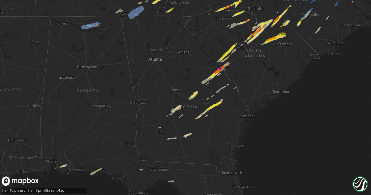
Hail Map in Georgia on May 6, 2022
Get this storm
May 6 map
$229
one time, instant access
Download today. No call, no setup
Keep the $229
Bought the map and want the full workflow? Apply the entire $229 to a subscription within 7 days. None of it is wasted.
Every map, not just this one
This buys you this map. Subscription and you get every map we run, in the markets you choose from a few cities to whole states to nationwide. Plus real-time alerts the moment a storm fires.
Contact data
Name, contact info, occupancy, even credit band for addresses in the footprint. You go from where it hit to who to call.
Become the source they trust
Unlimited branding weather history reports on demand. You already have the documented answer ready for the property owner, and you are the one who showed up with it.
Property data and RoofTrace estimates
Pull up any address you have got, its value and the exact code rules for that jurisdiction, straight from One Click Code. Then RoofTrace estimates the squares, pitch, and roof value, priced the way you price.
Storm reports in Georgia
Georgia
| Date | Description |
|---|---|
| 05/06/20225:30 PM CDT | Public caller reports of tree down from thunderstorm winds near pine st / nichols st. One lane blocked. |
| 05/06/20224:52 PM CDT | Trees and power lines down in the valdosta area. |
| 05/06/20224:32 PM CDT | Trees and power lines down across the northern portions of lowndes county. |
| 05/06/20224:22 PM CDT | Multiple trees down along upper and lower river rd in hartford |
| 05/06/20223:55 PM CDT | Report from mping: ping pong ball sized hail |
| 05/06/20223:47 PM CDT | Public reported through social media of egg size hail neaer the university hospital and wrightsboro road. |
| 05/06/20223:47 PM CDT | Reported quarter size hail at augusta university. |
| 05/06/20223:46 PM CDT | Reported golf ball size hail along summer ridge drive in augusta. |
| 05/06/20223:45 PM CDT | Golf ball sized hail and 50 mph wind gusts reported near augusta national golf course. |
| 05/06/20223:45 PM CDT | Reported a large tree down across river north driver in north augusta. |
| 05/06/20223:45 PM CDT | Public reported through social media of large hail that ranged from 1 inch up to just over 2 inches along pennsylvania avenue near clifton street. |
| 05/06/20223:44 PM CDT | Reported golf ball size hail at daniel field. |
| 05/06/20223:43 PM CDT | Report from media of hail just larger than 2 inches at the first baptist church at wheeler road and jackson road. |
| 05/06/20223:41 PM CDT | Reported half dollar size hail at fort gordon. |
| 05/06/20223:36 PM CDT | Reported trees down at the intersection of horizon south pkwy. And gateway blvd. |
| 05/06/20223:36 PM CDT | City of grovetown reports trees and power lines down in several areas of the city. Some impacted locations include railroad ave.... Harlem grovetown rd in the area of f |
| 05/06/20223:27 PM CDT | Public reported numerous trees and power lines down on hwy 221. |
| 05/06/20223:27 PM CDT | Burke county dispatch reported widespread trees and powerlines down across the county. Time estimated on radar. |
| 05/06/20223:24 PM CDT | Several trees down on hwy 221 n near the jefferson/mcduffie county line. |
| 05/06/20223:19 PM CDT | Multiple trees reported down along hwy 221 n between airport rd and ellis cemetary rd. |
| 05/06/20223:18 PM CDT | Screven county warning point reported trees down along scarboro highway. Time estimated from radar. |
| 05/06/20223:15 PM CDT | Tree down on caylor rd. |
| 05/06/20223:03 PM CDT | A few trees... Along with powerlines... Reported down near the intersection of hwy 56 n and hwy 192 n |
| 05/06/20223:01 PM CDT | Tree down at the intersection of huckleberry rd and oak grove church rd. |
| 05/06/20223:00 PM CDT | A tree was downed across highway 41 near three notch road. |
| 05/06/20223:00 PM CDT | Candler county sheriff reported quarter sized hail along route 23 about 3 miles north of metter. |
| 05/06/20223:00 PM CDT | A large tree fell across graysville road and downed power lines as well. |
| 05/06/20222:58 PM CDT | Multiple trees and powerlines down in the town of davisboro |
| 05/06/20222:58 PM CDT | Tree reported down on a home on the 200 block of n central st in swainsboro. |
| 05/06/20222:56 PM CDT | Law enforcement relayed a photo of ping pong ball sized hail which fell along olifftown road. Time was estimated from radar data. |
| 05/06/20222:53 PM CDT | Candler county sheriff reported quarter sized hail along route 23 about 3 miles north of metter. Corrected time of event based on radar data. |
| 05/06/20222:53 PM CDT | Emergency manager relayed report of trees down along olifftown road. Time estimated from radar. |
| 05/06/20222:45 PM CDT | Tree down in woods. |
| 05/06/20222:40 PM CDT | Roof removed from a manufactured home on ralph young rd. |
| 05/06/20222:39 PM CDT | Emergency manager relayed report of powerlines down along macwac lake road. Time estimated from radar. |
| 05/06/20222:38 PM CDT | Golf ball sized hail at the intersection of watermelon rd and hwy 157. |
| 05/06/20222:36 PM CDT | Roof removed from a manufactued home on the 100 block of columbia st. |
| 05/06/20222:36 PM CDT | A large tree was downed across arnold road in rock spring. |
| 05/06/20222:36 PM CDT | Tree reported down on hwy 29 near the intersection of brick mill rd. |
| 05/06/20222:31 PM CDT | Tree down along the 900 block of pope creek rd |
| 05/06/20222:30 PM CDT | Tree down on nobles rd. |
| 05/06/20222:30 PM CDT | Tree down on powerlines on prospect church rd. |
| 05/06/20222:30 PM CDT | Tree down near the intersection of hwy 199 and mercer creek rd. |
| 05/06/20222:27 PM CDT | Several trees were downed on and near lookout mountain... Including on scenic hwy... Wooten drive... Phillips lane... Creek rd... And sarah chapel rd. |
| 05/06/20222:25 PM CDT | Several trees were downed in trenton including on wren ave... Poplar st... Bond ave... And jeffery town road. |
| 05/06/20222:24 PM CDT | Tree down along the 900 block of byrds chapel rd. |
| 05/06/20222:23 PM CDT | Trees were downed west of trenton including on mcbryar rd... Worley chapel rd... Ga-301... And owenby filler rd. |
| 05/06/20222:18 PM CDT | Half-dollar sized hail reported in kibbee... Ga. |
| 05/06/20222:13 PM CDT | Tree and powerlines down near intersection of bear branch rd and ivory dr |
| 05/06/20222:13 PM CDT | Tree and powerlines down near intersection of klondike rd and barrett rd |
| 05/06/20222:07 PM CDT | Mutliple large trees down around property off of antioch road... North of cochran. |
| 05/06/20222:07 PM CDT | Multiple trees reported down on macedonia church rd. |
| 05/06/20222:06 PM CDT | Tree down across road on ga-247 near waste treatment plant. |
| 05/06/20221:55 PM CDT | Roof damage at rebels rd and bobby rd |
| 05/06/20221:50 PM CDT | Multiple trees down near the intersection of county line rd and poke rd |
| 05/06/20221:50 PM CDT | Tree down on power lines. |
| 05/06/20221:50 PM CDT | Corrects time of previous tstm wnd dmg report from 1 ene norman park. Tree on car at serena dr. |
| 05/06/20221:50 PM CDT | Multiple trees reported down near intersection of ga-26 and loggins rd |
| 05/06/20221:45 PM CDT | Tree reported down on sweet gum rd. |
| 05/06/20221:45 PM CDT | Powerline down at harris st and hwy 82. |
| 05/06/20221:45 PM CDT | Tree and powerlines down at 255 whitley rd. |
| 05/06/20221:45 PM CDT | Tree down at north hwy 125 at vanceville. |
| 05/06/20221:45 PM CDT | Roof peeled off structure near intersection of langford rd and everett rd. |
| 05/06/20221:45 PM CDT | Tree reported down on poplar st near intersection with 3rd ave. |
| 05/06/20221:38 PM CDT | Tree down near the intersection of ga-112 and christian hill rd |
| 05/06/20221:35 PM CDT | Tree on car at serena dr. |
| 05/06/20221:35 PM CDT | Trees at sr37 west and summerlin road down tree on vehicle in norman park. |
| 05/06/20221:34 PM CDT | Tree reported down on bowen rd near the intersection with calhoun rd. |
| 05/06/20221:30 PM CDT | Tree down on pansey rd. |
| 05/06/20221:30 PM CDT | Tree down at satilla church rd near lotus rd. |
| 05/06/20221:30 PM CDT | A local report indicates 1.00 inch wind near 5 SE HOLT |
| 05/06/20221:30 PM CDT | Tree down on althea rd between begonia and plum. |
| 05/06/202212:40 PM CDT | Tree down blocking pleasant hill road. |
| 05/06/20223:46 AM CDT | At 845 PM EDT, severe thunderstorms were located along a line extending from near Taylor to near Lulu, moving east at 25 mph. HAZARD...60 mph wind gusts and penny size hail. SOURCE...Radar indicated. IMPACT...Expect damage to roofs, siding, and trees. Locations impacted include... Lake Butler, Taylor, Glen St. Mary, Palestine Community, Lulu, Olustee, Sanderson and Johnstown. |
| 05/06/20221:58 AM CDT | At 657 PM EDT, a severe thunderstorm was located 10 miles northeast of Jasper, moving east at 30 mph. HAZARD...60 mph wind gusts and penny size hail. SOURCE...Radar indicated. IMPACT...Expect damage to roofs, siding, and trees. Locations impacted include... Needmore. |
| 05/06/202212:17 AM CDT | At 517 PM EDT, a severe thunderstorm was located near Hawkinsville, moving east at 30 mph. HAZARD...60 mph wind gusts and quarter size hail. SOURCE...Radar indicated. IMPACT...Hail damage to vehicles is expected. Expect wind damage to roofs, siding, and trees. Locations impacted include... Cochran, Hawkinsville, Dubois, Gresston, Empire, Mobley Crossing, Hartford, Roddy, Pulaski State Prison, Baileys Park and Browndale. |
| 05/05/202211:49 PM CDT | At 448 PM EDT, a severe thunderstorm was located near Burtons Ferry Landing, moving northeast at 65 mph. HAZARD...60 mph wind gusts and quarter size hail. SOURCE...Radar indicated. IMPACT...Minor hail damage to vehicles is possible. Expect wind damage to trees and powerlines. Locations impacted include: Allendale, Hampton, Lake Warren State Park, Fairfax, Brunson, Gifford, Sycamore, Luray, Ulmer, Crocketville, Seigling, Martin, Miley, Barton and Millett. |
| 05/05/202211:28 PM CDT | At 427 PM EDT, a severe thunderstorm was located over Alexander, or 10 miles southwest of Plant Vogtle, moving northeast at 65 mph. HAZARD...60 mph wind gusts and quarter size hail. SOURCE...Radar indicated. IMPACT...Hail damage to vehicles is expected. Expect wind damage to trees and powerlines. Locations impacted include... Waynesboro, Barnwell, Savannah River Site, Plant Vogtle, Sardis, Alexander, Burke County Airport, Snelling, Kline, Girard, Di- Lane Wildlife Management Area, Savannah River Site H Canyon, Savannah River Site K Complex and Shell Bluff. |
| 05/05/202211:16 PM CDT | At 415 PM EDT, a severe thunderstorm was located over Scarboro, moving northeast at 50 mph. HAZARD...60 mph wind gusts and quarter size hail. SOURCE...Radar indicated. IMPACT...Minor hail damage to vehicles is possible. Expect wind damage to trees and powerlines. Locations impacted include: Millen, Sylvania, Butts, Hiltonia, Newington, Oliver, Rocky Ford, Altman, Perkins, Dover, Emmalane, Millhaven, Scarboro, Woodcliff and Hilltonia. |
| 05/05/202211:03 PM CDT | At 402 PM EDT, a severe thunderstorm was located over Midville, or 14 miles north of Swainsboro, moving northeast at 55 mph. HAZARD...60 mph wind gusts and quarter size hail. SOURCE...Radar indicated. IMPACT...Hail damage to vehicles is expected. Expect wind damage to trees and powerlines. Locations impacted include... Waynesboro, Sardis, Midville, Alexander, Gough, Burke County Airport, Keysville, Vidette, Di- Lane Wildlife Management Area, Magruder and Rosier. |
| 05/05/202211:00 PM CDT | At 400 PM EDT, severe thunderstorms were located along a line extending from near Agricola to near Twin City, moving northeast at 65 mph. HAZARD...60 mph wind gusts and quarter size hail. SOURCE...Radar indicated. IMPACT...Hail damage to vehicles is expected. Expect wind damage to roofs, siding, and trees. Locations impacted include... Louisville, Wrens, Wadley, Stapleton, Avera, Garfield, Summertown, Canoochee, Grange, Stapletons Crossroads, Matthews, Three Points, Moxley, Stellaville and Colemans Lake. |
| 05/05/202210:37 PM CDT | At 337 PM EDT, severe thunderstorms were located along a line extending from near Oconee to near Zaidee, moving northeast at 55 mph. HAZARD...60 mph wind gusts and quarter size hail. SOURCE...Radar indicated. IMPACT...Hail damage to vehicles is expected. Expect wind damage to roofs, siding, and trees. Locations impacted include... Swainsboro, Sandersville, Wrightsville, Wadley, Davisboro, Tennille, Adrian, Harrison, Bartow, Oconee, Summertown, Riddleville, Kite, Spann, Downs, Covena, Modoc, Norristown, Pringle and Dellwood. |
| 05/05/202210:35 PM CDT | At 334 PM EDT, a severe thunderstorm was located near Oak Park, moving northeast at 45 mph. HAZARD...60 mph wind gusts and quarter size hail. SOURCE...Radar indicated. IMPACT...Minor hail damage to vehicles is possible. Expect wind damage to trees and powerlines. Locations impacted include: Statesboro, Metter, Brooklet, Portal, Cobbtown, Pulaski, Register, Aline, Georgia Southern and Hopeulikit.This warning includes I-16 between mile markers 96 and 114. |
| 05/05/202210:30 PM CDT | At 330 PM EDT, a severe thunderstorm was located over Normantown, or 8 miles north of Lyons, moving northeast at 40 mph. HAZARD...60 mph wind gusts and quarter size hail. SOURCE...Radar indicated. IMPACT...Hail damage to vehicles is expected. Expect wind damage to roofs, siding, and trees. Locations impacted include... Lyons, Vidalia, Stillmore, Oak Park and Normantown. |
| 05/05/202210:24 PM CDT | At 323 PM EDT, a severe thunderstorm was located near Pridgen, or 7 miles north of Ambrose, moving northeast at 40 mph. HAZARD...60 mph wind gusts. SOURCE...Radar indicated. IMPACT...Expect damage to roofs, siding, and trees. Locations impacted include... Pridgen. |
| 05/05/202210:13 PM CDT | At 313 PM EDT, a severe thunderstorm was located over Danville, or 8 miles southeast of Jeffersonville, moving northeast at 60 mph. HAZARD...60 mph wind gusts and quarter size hail. SOURCE...Radar indicated. IMPACT...Hail damage to vehicles is expected. Expect wind damage to roofs, siding, and trees. Locations impacted include... Jeffersonville, Irwinton, McIntyre, Dudley, Toomsboro, Danville, Montrose, Allentown, Chappells Mill, Nicklesville and Ripley. |
| 05/05/202210:09 PM CDT | At 309 PM EDT, a severe thunderstorm was located over Cadwell, or 14 miles northeast of Eastman, moving northeast at 60 mph. HAZARD...60 mph wind gusts and quarter size hail. SOURCE...Radar indicated. IMPACT...Hail damage to vehicles is expected. Expect wind damage to roofs, siding, and trees. Locations impacted include... Dublin, Soperton, East Dublin, Dexter, Dudley, Cadwell, Rentz, Lothair, Cedar Grove, Orland, Rockledge, Orianna, Minter, Lovett, Harlow, Brewton, Lowery and Tuckers Crossroad. |
| 05/05/202210:06 PM CDT | At 306 PM EDT, a severe thunderstorm was located over Mount Vernon, moving northeast at 40 mph. HAZARD...60 mph wind gusts and quarter size hail. SOURCE...Radar indicated. IMPACT...Hail damage to vehicles is expected. Expect wind damage to roofs, siding, and trees. Locations impacted include... Mount Vernon, Vidalia, Ailey, Higgston, Tarrytown and Kibbee. |
| 05/05/202210:03 PM CDT | At 302 PM EDT, a severe thunderstorm was located 7 miles northeast of Alapaha, or 9 miles southeast of Ocilla, moving northeast at 45 mph. HAZARD...60 mph wind gusts and nickel size hail. SOURCE...Radar indicated. IMPACT...Expect damage to roofs, siding, and trees. Locations impacted include... Douglas, Broxton, Ambrose, Pridgen and West Green. |
| 05/05/20229:58 PM CDT | At 257 PM EDT, a severe thunderstorm was located 7 miles south of Greensboro, or 12 miles southwest of Quincy, moving northeast at 25 mph. HAZARD...60 mph wind gusts and quarter size hail. SOURCE...Radar indicated. IMPACT...Hail damage to vehicles is expected. Expect wind damage to roofs, siding, and trees. Locations impacted include... Quincy, Midway, Havana, Greensboro, Gretna, Freemont, Lake Talquin, Littman, Juniper, Douglas City, Florence, Hosford, Scotland, Jamieson, Fort Braden, Santa Clara, Shady Rest, Quincy Airport, Lowry and Wetumpka. |
| 05/05/20229:51 PM CDT | At 251 PM EDT, a severe thunderstorm was located over Klondike, or 7 miles northwest of Hawkinsville, moving northeast at 45 mph. HAZARD...70 mph wind gusts and quarter size hail. SOURCE...Radar indicated. IMPACT...Hail damage to vehicles is expected. Expect considerable tree damage. Wind damage is also likely to mobile homes, roofs, and outbuildings. Locations impacted include... Cochran, Hawkinsville, Marion, Hayneville, Browndale, Tarversville, Mobley Crossing, Baileys Park, Royal, District Path, Ocmulgee Public Fishing Area, Paulk, Goldsboro, Cary, Pulaski State Prison, Porter, Kathleen, Coley Station, Sand Bed and Bullard. |
| 05/05/20229:48 PM CDT | At 247 PM EDT, a severe thunderstorm was located over Ocmulgee Banks, or 9 miles north of Abbeville, moving northeast at 45 mph. HAZARD...60 mph wind gusts and quarter size hail. SOURCE...Radar indicated. IMPACT...Hail damage to vehicles is expected. Expect wind damage to roofs, siding, and trees. Locations impacted include... Eastman, Chester, Union, Dubois, Gresston, Plainfield, Empire, Yonkers, Cedar Creek, Roddy, Rowland, Ocmulgee Banks and Godwinsville. |
| 05/05/20229:48 PM CDT | At 248 PM EDT, a severe thunderstorm was located over Enigma, or 11 miles east of Tifton, moving northeast at 40 mph. HAZARD...60 mph wind gusts and quarter size hail. SOURCE...Radar indicated. IMPACT...Hail damage to vehicles is expected. Expect wind damage to roofs, siding, and trees. Locations impacted include... Tifton, Enigma, Alapaha, Vanceville, Gladys, Glory, Wray and Brookfield. |
| 05/05/20229:40 PM CDT | At 240 PM EDT, a severe thunderstorm was located near Scotland, or near McRae, moving northeast at 35 mph. HAZARD...60 mph wind gusts and quarter size hail. SOURCE...Radar indicated. IMPACT...Hail damage to vehicles is expected. Expect wind damage to roofs, siding, and trees. Locations impacted include... McRae, Alamo, Glenwood, Scotland, Towns, Spring Hill and Jordan. |
| 05/05/20229:37 PM CDT | At 236 PM EDT, a severe thunderstorm was located over Pinehurst, or 8 miles northeast of Vienna, moving northeast at 35 mph. HAZARD...60 mph wind gusts and quarter size hail. SOURCE...Radar indicated. IMPACT...Hail damage to vehicles is expected. Expect wind damage to roofs, siding, and trees. Locations impacted include... Hawkinsville, Vienna, Unadilla, Pinehurst, Hayneville, Browndale, Wallace, Grovania, Elko, Mock Springs and Klondike. |
| 05/05/20229:36 PM CDT | At 235 PM EDT, a severe thunderstorm was located near Riverside, or near Moultrie, moving northeast at 50 mph. HAZARD...60 mph wind gusts and quarter size hail. SOURCE...Radar indicated. IMPACT...Hail damage to vehicles is expected. Expect wind damage to roofs, siding, and trees. Locations impacted include... Tifton, Moultrie, Adel, Sparks, Omega, Norman Park, Lenox, Doerun, Pavo, Coolidge, Phillipsburg, Unionville, Riverside, Schley, Berlin, Funston, Ellenton, Reed Bingham State Park, Minton and Scooterville. |
| 05/05/20229:31 PM CDT | At 231 PM EDT, a severe thunderstorm was located over Seville, or 11 miles east of Cordele, moving northeast at 35 mph. HAZARD...60 mph wind gusts and quarter size hail. SOURCE...Radar indicated. IMPACT...Hail damage to vehicles is expected. Expect wind damage to roofs, siding, and trees. Locations impacted include... Abbeville, Rochelle, Pineview, Pitts, Pope City and Cedar Creek. |
| 05/05/20229:22 PM CDT | At 222 PM EDT, a severe thunderstorm was located over Camp Merrill, or 8 miles northwest of Dahlonega, moving northeast at 40 mph. HAZARD...60 mph wind gusts and quarter size hail. SOURCE...Radar indicated. IMPACT...Hail damage to vehicles is expected. Expect wind damage to roofs, siding, and trees. Locations impacted include... Dahlonega, Suches, Camp Merrill, Whitley Gap Shelter, Woods Hole Shelter, Low Gap Shelter, Camp Coleman Lake, Owltown, Vogel State Park, Hawk Mountain Shelter, Smithgall Woods Conservation Are, Porter Springs, Turners Corner, Nimblewill, Blood Mountain Shelter, Gaddistown, Gooch Mountain Shelter and Qualatchee Lake. |
| 05/05/20229:20 PM CDT | At 220 PM EDT, a severe thunderstorm was located over Drayton, or 9 miles west of Vienna, moving northeast at 35 mph. HAZARD...60 mph wind gusts and quarter size hail. SOURCE...Radar indicated. IMPACT...Hail damage to vehicles is expected. Expect wind damage to roofs, siding, and trees. Locations impacted include... Vienna, Byromville, Pinehurst, Lilly, Flint River Wma and Drayton. |
| 05/05/20229:19 PM CDT | At 218 PM EDT, a severe thunderstorm was located 7 miles north of Alapaha, or 7 miles southeast of Ocilla, moving east at 35 mph. HAZARD...60 mph wind gusts and quarter size hail. SOURCE...Radar indicated. IMPACT...Hail damage to vehicles is expected. Expect wind damage to roofs, siding, and trees. Locations impacted include... Douglas, Broxton and Ambrose. |
| 05/05/20229:14 PM CDT | At 213 PM CDT, a severe thunderstorm was located near Bridgeport, moving east at 55 mph. HAZARD...60 mph wind gusts. SOURCE...Radar indicated. IMPACT...Expect damage to roofs, siding, and trees. Locations impacted include... Bridgeport and Higdon. |
| 05/05/20229:12 PM CDT | At 211 PM EDT/111 PM CDT/, a severe thunderstorm was located near Blountstown, moving east at 35 mph. HAZARD...60 mph wind gusts and quarter size hail. SOURCE...Radar indicated. IMPACT...Hail damage to vehicles is expected. Expect wind damage to roofs, siding, and trees. Locations impacted include... Blountstown, Quincy, Greensboro, Chattahoochee, Gretna, Bristol, Altha, Rock Bluff, Clarksville, Ocheesee, Juniper, Douglas City, Selman, Abe Springs, Hosford, Rosedale, Chipola, Henderson Mill, Clio and Scotts Ferry. |
| 05/05/20229:06 PM CDT | At 206 PM EDT, a severe thunderstorm was located near Enigma, or 9 miles east of Tifton, moving east at 30 mph. HAZARD...60 mph wind gusts and quarter size hail. SOURCE...Radar indicated. IMPACT...Hail damage to vehicles is expected. Expect wind damage to roofs, siding, and trees. Locations impacted include... Enigma, Wray, Brookfield and Gladys. |
| 05/05/20228:25 PM CDT | At 125 PM EDT/1225 PM CDT/, a severe thunderstorm was located 18 miles west of Blountstown, moving east at 40 mph. HAZARD...60 mph wind gusts and quarter size hail. SOURCE...Radar indicated. IMPACT...Hail damage to vehicles is expected. Expect wind damage to roofs, siding, and trees. Locations impacted include... Blountstown, Chattahoochee, Bristol, Altha, Rock Bluff, Moose Pond, Clarksville, Ocheesee, Selman, Abe Springs, Fountain, Hosford, Rosedale, Chipola, Henderson Mill, Camps Head, Clio, Scotts Ferry, Kennys Mill and Estiffanulga. |
| 05/05/20228:21 PM CDT | At 121 PM EDT, severe thunderstorms were located along a line extending from 7 miles southwest of Shellman to near Leary, moving northeast at 45 mph. HAZARD...60 mph wind gusts and quarter size hail. SOURCE...Radar indicated. IMPACT...Hail damage to vehicles is expected. Expect wind damage to roofs, siding, and trees. Locations impacted include... Morgan, Albany, Ashburn, Dawson, Leesburg, Shellman, Leary, Smithville, East Albany, Marine Corps Logistics Base, Turner City, Walker, Worth, Sycamore, Warwick, Sasser, Bronwood, Stocks, Radium Springs and Dawson Municipal A/P. |
| 05/05/20228:07 PM CDT | At 107 PM EDT, a severe thunderstorm was located 7 miles southwest of Ty Ty, or 10 miles southeast of Sylvester, moving east at 35 mph. HAZARD...60 mph wind gusts and quarter size hail. SOURCE...Radar indicated. IMPACT...Hail damage to vehicles is expected. Expect wind damage to roofs, siding, and trees. Locations impacted include... Tifton, Enigma, Omega, Ty Ty, Phillipsburg, Unionville, Vanceville, Minton, Hillsdale, Eldorado, Scooterville, Tempy, Powelltown, Harding, Tift Airport, Fender and Brookfield. |
All States Impacted by Hail Map on May 6, 2022
Cities Impacted by Hail Map on May 6, 2022
- Monroe, TN
- Greeneville, TN
- Mosheim, TN
- Del Rio, TN
- Liberty, KY
- Clarkson, KY
- Leitchfield, KY
- Pittsboro, NC
- Bear Creek, NC
- Siler City, NC
- Bennett, NC
- Macclesfield, NC
- Wilson, NC
- Fountain, NC
- Stantonsburg, NC
- Walstonburg, NC
- Ahoskie, NC
- Plymouth, NC
- Cadiz, KY
- Pigeon Forge, TN
- Sevierville, TN
- Sylvania, GA
- Allendale, SC
- Blanch, NC
- Madison, NC
- Mayodan, NC
- Providence, NC
- Pelham, NC
- Milton, NC
- Stoneville, NC
- Walnut Cove, NC
- Reidsville, NC
- Yanceyville, NC
- Ruffin, NC
- Pine Hall, NC
- Shannon, NC
- Fayetteville, NC
- Raeford, NC
- Lumber Bridge, NC
- Lafitte, LA
- Barataria, LA
- Scottsburg, VA
- Virgilina, VA
- Red Oak, VA
- Clarksville, VA
- Skipwith, VA
- New Market, TN
- Strawberry Plains, TN
- Birchwood, TN
- Decatur, TN
- Staley, NC
- Liberty, NC
- Prosperity, SC
- Leesville, SC
- Mount Gilead, NC
- Swainsboro, GA
- Alamo, GA
- Mount Vernon, GA
- Vidalia, GA
- Twin City, GA
- Ailey, GA
- Tarrytown, GA
- Portal, GA
- Glenwood, GA
- Lyons, GA
- Metter, GA
- McRae Helena, GA
- Englewood, TN
- Tellico Plains, TN
- Madisonville, TN
- Vonore, TN
- Windsor, NC
- Augusta, GA
- Blythe, GA
- Pitts, GA
- Rochelle, GA
- Pineview, GA
- Abbeville, GA
- Loudon, TN
- Lenoir City, TN
- Kingston, TN
- Philadelphia, TN
- Ten Mile, TN
- Vienna, GA
- Chester, SC
- McConnells, SC
- Rock Hill, SC
- Buffalo, SC
- Union, SC
- Sharon, SC
- Lockhart, SC
- Briceville, TN
- Ward, SC
- Crossville, TN
- Irwinton, GA
- Tennille, GA
- Wrightsville, GA
- Montrose, GA
- Dublin, GA
- Toomsboro, GA
- Dudley, GA
- East Dublin, GA
- Omega, GA
- Doerun, GA
- Sylvester, GA
- Ty Ty, GA
- Tifton, GA
- Sumner, GA
- Robersonville, NC
- Williamston, NC
- Clinton, NC
- Turkey, NC
- Westfield, NC
- Danbury, NC
- Lawsonville, NC
- Abingdon, VA
- Bristol, TN
- Morgantown, KY
- New Hope, KY
- Loretto, KY
- Ayden, NC
- Sardis, GA
- Sweeny, TX
- Garysburg, NC
- Jackson, NC
- Tyler, TX
- Lindale, TX
- Battleboro, NC
- Murfreesboro, NC
- Como, NC
- Rich Square, NC
- Halifax, NC
- Whitakers, NC
- Enfield, NC
- Conway, NC
- Seaboard, NC
- Woodland, NC
- Scotland Neck, NC
- Tarboro, NC
- Marble, NC
- Andrews, NC
- Murphy, NC
- Rockingham, NC
- Bennettsville, SC
- Wallace, SC
- Hamlet, NC
- Laurel Hill, NC
- Laurel Springs, NC
- Wytheville, VA
- Pulaski, VA
- Draper, VA
- Max Meadows, VA
- Corapeake, NC
- Chesapeake, VA
- Suffolk, VA
- Winterville, NC
- Byrdstown, TN
- Pioneer, TN
- Avera, GA
- Louisville, GA
- Trenton, SC
- Sandersville, GA
- Hephzibah, GA
- Matthews, GA
- Gibson, GA
- Stapleton, GA
- Warthen, GA
- Graniteville, SC
- Beech Island, SC
- Aiken, SC
- Davisboro, GA
- Wrens, GA
- North Augusta, SC
- Keysville, GA
- Sweetwater, TN
- Niota, TN
- Parrottsville, TN
- Uvalda, GA
- Smyrna, SC
- Gaffney, SC
- York, SC
- Clover, SC
- Gastonia, NC
- Blacksburg, SC
- Pinetops, NC
- Jonesville, SC
- Enoree, SC
- Maxton, NC
- Red Springs, NC
- Jamesville, NC
- Edgefield, SC
- Clarks Hill, SC
- Johnston, SC
- Saluda, SC
- Batesburg, SC
- Newberry, SC
- Fairhope, AL
- Greenville, NC
- Emporia, VA
- Lancing, TN
- Unadilla, GA
- Pinehurst, GA
- Newsoms, VA
- Franklin, VA
- Youngsville, NC
- Perry, FL
- Lamont, FL
- Lancaster, SC
- Destin, FL
- Miramar Beach, FL
- Franklinville, NC
- Randleman, NC
- Modoc, SC
- Columbia, KY
- South Boston, VA
- Alton, VA
- Ridgeway, SC
- Monticello, KY
- Nancy, KY
- Gainesboro, TN
- Kelford, NC
- Aulander, NC
- Lewiston Woodville, NC
- Knoxville, TN
- Henderson, TN
- Tracy City, TN
- Sewanee, TN
- South Pittsburg, TN
- Whitwell, TN
- Sequatchie, TN
- Jetson, KY
- Roundhill, KY
- Bowling Green, KY
- Merry Hill, NC
- Athens, TN
- Windsor, VA
- Zuni, VA
- Albany, KY
- Hollister, NC
- Warrenton, NC
- Surgoinsville, TN
- Rogersville, TN
- Eidson, TN
- Ellenboro, NC
- Forest City, NC
- Rutherfordton, NC
- Columbus, NC
- Campobello, SC
- Chesnee, SC
- Mooresboro, NC
- Landrum, SC
- Cherryville, NC
- Lincolnton, NC
- Lawndale, NC
- Crouse, NC
- Shelby, NC
- Elko, GA
- Hawkinsville, GA
- Riceville, TN
- Tallassee, TN
- Leesburg, GA
- Chapin, SC
- Society Hill, SC
- Cassatt, SC
- Bethune, SC
- Darlington, SC
- Camden, SC
- Hartsville, SC
- Bishopville, SC
- McBee, SC
- Grimesland, NC
- Bethel, NC
- Greenback, TN
- Maryville, TN
- Greensboro, NC
- Winnsboro, SC
- Jamestown, NC
- High Point, NC
- Pleasant Garden, NC
- Freeman, VA
- Jarratt, VA
- McKenney, VA
- Stokes, NC
- Ambrose, GA
- Alapaha, GA
- Enigma, GA
- Wray, GA
- Ocilla, GA
- Wadesboro, NC
- Springfield, KY
- Bardstown, KY
- Asheboro, NC
- Heppner, OR
- Lyles, TN
- Eagle Springs, NC
- West End, NC
- Carthage, NC
- Spray, OR
- Monument, OR
- Anthony, FL
- Pearland, TX
- Fresno, TX
- Rosharon, TX
- Missouri City, TX
- Manvel, TX
- Glade Spring, VA
- Chilhowie, VA
- Marion, VA
- Watertown, TN
- Milton, TN
- Mount Croghan, SC
- Ellerbe, NC
- Jackson Springs, NC
- Chesterfield, SC
- Morven, NC
- Candor, NC
- Lilesville, NC
- Ruby, SC
- Newport, TN
- Bybee, TN
- Midway, TN
- Mohawk, TN
- Gillett, TX
- Karnes City, TX
- Saltville, VA
- Bristol, VA
- Meadowview, VA
- Adrian, GA
- Eden, NC
- Spring City, TN
- Dayton, TN
- Evensville, TN
- Morrisville, NC
- New Hill, NC
- Apex, NC
- Chapel Hill, NC
- Wake Forest, NC
- Cary, NC
- Durham, NC
- Raleigh, NC
- Heath Springs, SC
- Monroe, NC
- Jefferson, SC
- Great Falls, SC
- Marshville, NC
- Peachland, NC
- Pageland, SC
- Kershaw, SC
- Liberty Hill, SC
- Fort Lawn, SC
- Robertsdale, AL
- Summerdale, AL
- Huntsville, TN
- Perkins, GA
- Midville, GA
- Millen, GA
- Edgewater, FL
- Elizabethtown, NC
- Bristol, FL
- Hosford, FL
- Silverhill, AL
- Carrsville, VA
- Courtland, VA
- Bladenboro, NC
- Clarkton, NC
- Irmo, SC
- Little Mountain, SC
- Marietta, SC
- Travelers Rest, SC
- Rockford, TN
- Blythewood, SC
- Polkton, NC
- Bloomington Springs, TN
- Buffalo Valley, TN
- Baxter, TN
- Granville, TN
- Pilot Rock, OR
- Pendleton, OR
- Lexington, OR
- Weston, OR
- Mendota, VA
- Tryon, NC
- Cheraw, SC
- Mooresburg, TN
- Sneedville, TN
- Thorn Hill, TN
- Fort Oglethorpe, GA
- Cleveland, TN
- Apison, TN
- Chickamauga, GA
- Georgetown, TN
- Chattanooga, TN
- Ringgold, GA
- McDonald, TN
- Rossville, GA
- Lupton City, TN
- Ooltewah, TN
- Charleston, TN
- Hixson, TN
- Harrison, TN
- Alcoa, TN
- Louisville, TN
- Friendsville, TN
- Morristown, TN
- Talbott, TN
- Jefferson City, TN
- Stokesdale, NC
- Efland, NC
- Mebane, NC
- Daphne, AL
- Mobile, AL
- Bronston, KY
- Burnside, KY
- Spokane, WA
- Milton Freewater, OR
- Dudley, NC
- Goldsboro, NC
- Fort Bragg, NC
- Linden, NC
- Sophia, NC
- Garner, NC
- Willow Spring, NC
- Angier, NC
- Coats, NC
- Lillington, NC
- Earlysville, VA
- Charlottesville, VA
- North Garden, VA
- Belle Chasse, LA
- Huntsville, AL
- Harvest, AL
- Tanner, AL
- Gurley, AL
- Athens, AL
- Hollytree, AL
- Brownsboro, AL
- Madison, AL
- New Market, AL
- Grovetown, GA
- Germanton, NC
- Danville, VA
- Ringgold, VA
- Kings Mountain, NC
- Bessemer City, NC
- Harrison, GA
- Sandy Ridge, NC
- Spencer, VA
- Ridgeway, VA
- Afton, TN
- Chuckey, TN


