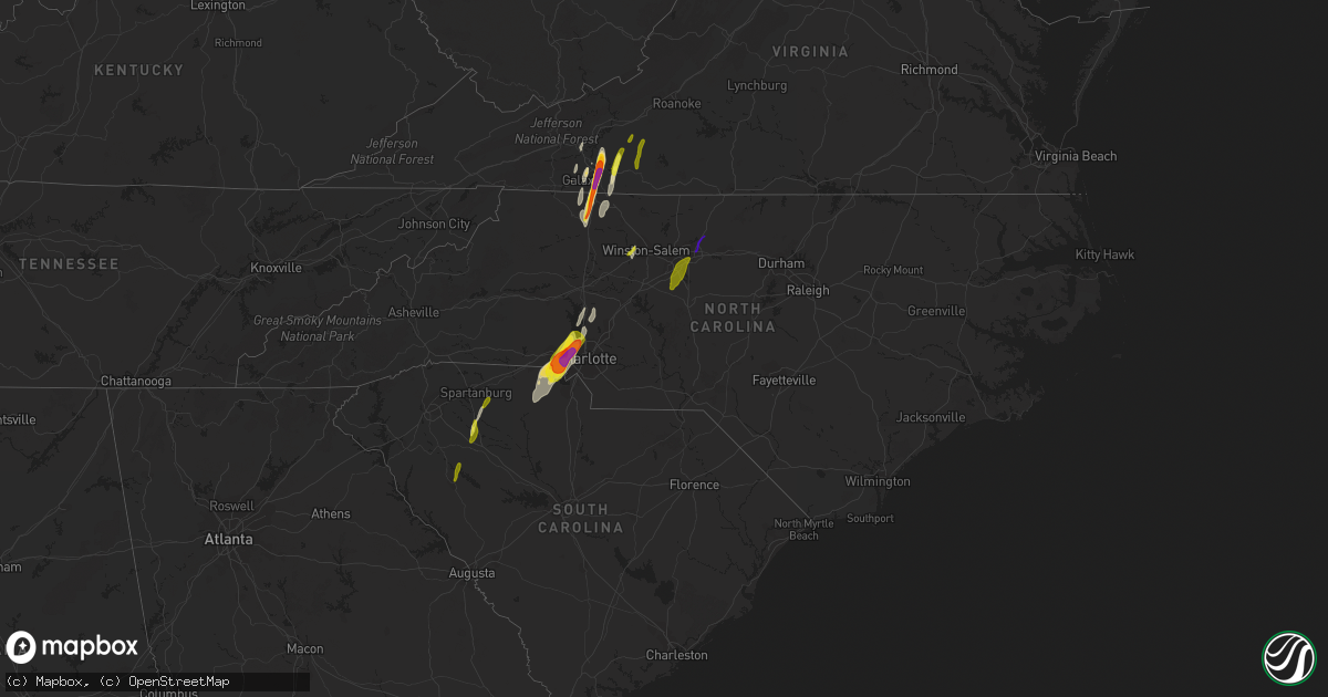
Hail Map in North Carolina on April 15, 2018
Get this storm
April 15 map
$229
one time, instant access
Download today. No call, no setup
Keep the $229
Bought the map and want the full workflow? Apply the entire $229 to a subscription within 7 days. None of it is wasted.
Every map, not just this one
This buys you this map. Subscription and you get every map we run, in the markets you choose from a few cities to whole states to nationwide. Plus real-time alerts the moment a storm fires.
Contact data
Name, contact info, occupancy, even credit band for addresses in the footprint. You go from where it hit to who to call.
Become the source they trust
Unlimited branding weather history reports on demand. You already have the documented answer ready for the property owner, and you are the one who showed up with it.
Property data and RoofTrace estimates
Pull up any address you have got, its value and the exact code rules for that jurisdiction, straight from One Click Code. Then RoofTrace estimates the squares, pitch, and roof value, priced the way you price.
Storm reports in North Carolina
North Carolina
| Date | Description |
|---|---|
| 04/15/20185:40 PM CDT | Tree down on farrington road. |
| 04/15/20185:30 PM CDT | Tree down on colon road. Time estimated by radar. |
| 04/15/20185:25 PM CDT | Multiple trees down in hurdle mills. |
| 04/15/20185:25 PM CDT | Tree down in the road on on west poplar road. |
| 04/15/20185:20 PM CDT | Tree down on lemon springs road. |
| 04/15/20185:20 PM CDT | Tree down on river forks drive near nc087. |
| 04/15/20185:15 PM CDT | Tree down on thompson avenue. |
| 04/15/20185:15 PM CDT | One tree was reported down at nc highway 86 and carr store road. |
| 04/15/20184:46 PM CDT | Numerous trees and power lines were reported down throughout the county. |
| 04/15/20184:45 PM CDT | Debris and bricks in roadway on us 15-501 in the area of cookout and walmart. Report via moore co twitter. |
| 04/15/20184:45 PM CDT | Tree down in road blocking one lane of glendon-carthage road. Report via moore co twitter. |
| 04/15/20184:45 PM CDT | Several trees reported down throughout the county. |
| 04/15/20184:45 PM CDT | Lots of structural and tree damage. Possible tornado. |
| 04/15/20184:40 PM CDT | Grooms road partially blocked from trees downed. Time estimated. |
| 04/15/20184:36 PM CDT | *** 5 inj *** tree on a house on 2300 block of highway 158 resulting in 5 non-life threatening injuries. Injured transported to local hospital. Time estimated. |
| 04/15/20184:36 PM CDT | Trees and power lines were reported down in siler city... Nc. |
| 04/15/20184:32 PM CDT | Rockingham county emergency manager reports several trees downed on top of houses along us 158 from monroeton to reidsville. |
| 04/15/20184:25 PM CDT | *** 7 inj *** tornado with ef1 damage along a nearly continuous path of 17.6 miles. Tornado lifted around 546 pm edt approximately 4 miles nne of the town of ruffin. Nu |
| 04/15/20184:20 PM CDT | Tree down on nc 24-27 hwy. Report via moore co twitter. |
| 04/15/20184:20 PM CDT | One tree was reported down on laurel hill church road. |
| 04/15/20184:17 PM CDT | Preliminary...large tree fell on a vehicle killing one occupant and injuring another. The time is estimated between 515 and 520 pm. |
| 04/15/20184:15 PM CDT | Damage was reported to homes... Along with numerous trees down and power lines at nealtown road and october lane... Greensboro... Nc. |
| 04/15/20184:13 PM CDT | Significant damage to at least one home and numerous trees reported down at queens beth drive... Greesnboro... Nc. |
| 04/15/20184:12 PM CDT | A large tree fell on a home... Causing significant damage. |
| 04/15/20184:10 PM CDT | A tornado was reported on the ground at gate city blvd and us 29... Greensboro... Nc. |
| 04/15/20184:10 PM CDT | An elementary school's roof was peeled off and windows blown out. Mobile units were destroyed. |
| 04/15/20184:06 PM CDT | Numerous trees and power lines reported down along with lots of debris near i-40 and us 421. |
| 04/15/20184:00 PM CDT | Several trees and power lines down. |
| 04/15/20184:00 PM CDT | Several trees and power lines down. |
| 04/15/20183:47 PM CDT | One tree was reported down at edgar rd and marlboro church rd... Randolph county... Nc. |
| 04/15/20183:45 PM CDT | Several trees and powerlines were blown down around the community of walnut cove. |
| 04/15/20183:45 PM CDT | Multiple large oak trees uprooted or snapped in half. Shingles off house. Indicated possible tornado. |
| 04/15/20183:40 PM CDT | Several trees were reported down across the eastern half of anson county. |
| 04/15/20183:35 PM CDT | Several trees were blown down by thunderstorm winds around the community of germanton. |
| 04/15/20183:31 PM CDT | One tree was reported down blocking the road near the intersection of lanier hill rd and new hope rd. |
| 04/15/20183:23 PM CDT | Half dollar hail reported off of lewisville-clemmons rd. |
| 04/15/20183:19 PM CDT | Trees and power lines were reported down near badin lake. |
| 04/15/20183:17 PM CDT | One tree was reported down at 9400 concord church road... Lewisville... Nc. |
| 04/15/20183:17 PM CDT | One tree was reported down at 1691 houser road... Lewisville... Nc. |
| 04/15/20183:17 PM CDT | One tree was reported down at 7600 shallowford road... Lewisville... Nc. |
| 04/15/20183:15 PM CDT | Trees down on dutch rd. Time estimated from radar. |
| 04/15/20183:07 PM CDT | Trees and power lines were reported down across the county... Some on houses. |
| 04/15/20183:06 PM CDT | Structural damage in downtown albemarle. Trees and power lines down... Closing glenn avenue and second street. |
| 04/15/20182:58 PM CDT | Multiple trees down on homes in the woodleaf area. Time estimated from radar. |
| 04/15/20182:58 PM CDT | Tree down at hayden way and dakeita circle. Time estimated from radar. |
| 04/15/20182:56 PM CDT | Tree down at bethel church rd and hwy 601 s. Time estimated from radar. |
| 04/15/20182:56 PM CDT | Tree down on miami church rd. Time estimated from radar. |
| 04/15/20182:54 PM CDT | Tree down on house on cool springs rd in woodleaf. Time estimated from radar. |
| 04/15/20182:46 PM CDT | Several trees and powerlines down on wallace rd in midland. Time estimated from radar. |
| 04/15/20182:46 PM CDT | Tree down in the roadway on corriher springs rd. Time estimated from radar. |
| 04/15/20182:43 PM CDT | Power lines were blown down along pine ridge road by thunderstorm winds. |
| 04/15/20182:42 PM CDT | Numerous large trees uprooted on biggers farm court. Time estimated from radar. |
| 04/15/20182:39 PM CDT | Tree down on house on unionville-brief rd. Numerous trees down in the area. Time estimated from radar. |
| 04/15/20182:38 PM CDT | Twitter report of multiple large trees downed on intersection of route 89 and horseshoe lane near francisco. Time estimated from radar. |
| 04/15/20182:38 PM CDT | Multiple calls of damage in southern iredell. About 10 trees down on southwest side of the golf course. Also roofs blown off houses and other structural damage. Other r |
| 04/15/20182:32 PM CDT | Tree down on house... Causing damage to the structure. Time estimated from radar. |
| 04/15/20182:30 PM CDT | A local report indicates 1.00 inch wind near 5 WSW HUNTERSVILLE |
| 04/15/20182:30 PM CDT | Tree down on house on doster rd. Time estimated from radar. |
| 04/15/20182:29 PM CDT | 2 trees down across s thompson st. |
| 04/15/20182:29 PM CDT | At least 4 trees down to the west of interstate 77 near lake norman. |
| 04/15/20182:29 PM CDT | Roof damamge to hotshots in mooresville. Time estimated from radar. |
| 04/15/20182:29 PM CDT | Roof damage to lake norman medical center. Time estimated from radar. |
| 04/15/20182:28 PM CDT | Tree down on highway 73 near beatties ford road. Blocking traffic. |
| 04/15/20182:27 PM CDT | Trees down on powerlines in cornelius. |
| 04/15/20182:27 PM CDT | Large tree down on erskine dr. Time estimated from radar. |
| 04/15/20182:25 PM CDT | Trees and barns knocked down at brown mill rd and beatties ford rd. Time estimated from radar. |
| 04/15/20182:24 PM CDT | Large oak tree blown down onto power lines on jane ave. Time estimated from radar. |
| 04/15/20182:24 PM CDT | Numerous trees down in the mountain island lake area. Time estimated from radar. |
| 04/15/20182:13 PM CDT | Kclt asos measured a 59 kt gust. |
| 04/15/20182:12 PM CDT | Hail up to hen egg size on valley view dr in belmont. Time estimated from radar. |
| 04/15/20182:12 PM CDT | Caller reported baseball-size hail in belmont. |
| 04/15/20182:10 PM CDT | Large tree on a house with occupants trapped near intersection of forest lane and brook forest drive in belmont. |
| 04/15/20182:10 PM CDT | Public reported golf ball |
| 04/15/20182:05 PM CDT | Tree blown down onto a house near intersection of forbes road and hemphill road. |
| 04/15/20181:48 PM CDT | A local report indicates 1.75 inch wind near PINE RIDGE |
| 04/15/20181:45 PM CDT | Quarter to half dollar size hail was observed falling for several minutes and covered the ground. |
| 04/15/201812:55 PM CDT | At least 3 trees were blown down by thunderstorm winds around the community of boomer. |
| 04/15/201812:25 PM CDT | A few trees blown down. |
| 04/15/201812:10 PM CDT | Several trees were down and blocking trails in south mountains state park. Time of tree falls estimated based on radar as the line of storms crossed the area. |
| 04/15/201811:37 AM CDT | A tree down on a powerline in henrietta and another tree down on a powerline near the cleveland county border to the west of mooresboro. |
| 04/15/201811:30 AM CDT | Trees and powerlines down on lions hill st. In morganton. Time estimated from radar. |
| 04/15/20187:29 AM CDT | At 1229 PM EDT, a severe thunderstorm was located 11 miles south of Forest City, or near Chesnee, moving northeast at 55 mph. HAZARD...60 mph wind gusts and quarter size hail. SOURCE...Radar indicated. IMPACT...Minor hail damage to vehicles is expected. Expect wind damage to trees and power lines. Locations impacted include... Forest City, Rutherfordton, Spindale, Boiling Springs NC, Cowpens, Mayo, Chesnee, Ellenboro, Lattimore and Mooresboro. |
| 04/15/20187:19 AM CDT | At 1219 PM EDT, a severe thunderstorm was located 7 miles north of Spartanburg, or near Mayo, moving northeast at 55 mph. HAZARD...60 mph wind gusts and quarter size hail. SOURCE...Radar indicated. IMPACT...Minor hail damage to vehicles is expected. Expect wind damage to trees and power lines. Locations impacted include... Spartanburg, Laurens, Boiling Springs SC, Woodruff, Duncan, Lyman, Wellford, Inman, Roebuck and Gray Court. |
| 04/15/20187:00 AM CDT | At 1159 AM EDT, a severe thunderstorm was located 10 miles northwest of Morganton, or near Table Rock, moving northeast at 45 mph. HAZARD...60 mph wind gusts and penny size hail. SOURCE...Radar indicated. IMPACT...Expect damage to trees and power lines. Locations impacted include... Morganton, Gamewell, Blowing Rock In Caldwell County, Glen Alpine, Table Rock, Edgemont, Collettsville, Ashford, Patterson and Jonas Ridge. |
| 04/15/20185:30 AM CDT | At 1029 PM EDT, severe thunderstorms were located along a line extending from 12 miles north of Clinton to 8 miles northwest of Harrells to near Rooks, moving northeast at 30 mph. HAZARD...60 mph wind gusts. SOURCE...Radar indicated. IMPACT...Expect damage to roofs, siding, and trees. Locations impacted include... Wallace, Warsaw, Mount Olive, Kornegay, Rose Hill, Beulaville, Bowdens, Cypress Creek, Beautancus, Kenansville, Chinquapin, Albertson, Harrells, Sarecta, Faison, Magnolia, Greenevers, Calypso, Lyman and Teachey. |
| 04/15/20185:26 AM CDT | At 1025 PM EDT, severe thunderstorms were located along a line extending from near Wake Forest to 9 miles northeast of Smithfield to 7 miles south of Clinton, moving northeast at 55 mph. HAZARD...60 mph wind gusts. SOURCE...Radar indicated. IMPACT...Expect damage to roofs, siding, and trees. Locations impacted include... Raleigh, Cary, Rocky Mount, Goldsboro, Smithfield, Clinton, Nashville, Wilson, Garner and Fuquay-Varina. |
| 04/15/20184:50 AM CDT | At 948 PM EDT, a line of severe thunderstorms stretched from near RDU International Airport to Creedmoor to Kerr Lake, with individual storms moving north at 50 mph as the line shifts east. HAZARD...60 mph wind gusts. SOURCE...Radar indicated. IMPACT...Expect damage to roofs, siding, and trees. Locations impacted include... Raleigh, Durham, Cary, Henderson, Oxford, Creedmoor, Louisburg, Warrenton, Wake Forest and Butner. |
| 04/15/20184:46 AM CDT | At 946 PM EDT, severe thunderstorms were located along a line extending from near Angier to near Godwin to near Ammon, moving north at 70 mph. HAZARD...60 mph wind gusts. SOURCE...Radar indicated. IMPACT...Expect damage to roofs, siding, and trees. Locations impacted include... Raleigh, Cary, Goldsboro, Smithfield, Clinton, Lillington, Garner, Fuquay-Varina, Clayton and Dunn. |
| 04/15/20183:38 AM CDT | At 837 PM EDT, a severe thunderstorm was located near Clarksville, or 14 miles east of Virgilina, moving northeast at 55 mph. HAZARD...60 mph wind gusts and penny size hail. SOURCE...Radar indicated. IMPACT...Expect damage to trees and powerlines. This severe thunderstorm will be near, Clarksville around 840 PM EDT. Boydton around 850 PM EDT. Chase City around 855 PM EDT. Rehoboth and Kells Corner around 905 PM EDT. Other locations impacted by this severe thunderstorm include Gary,Wilburn, Spanish Grove, Loves Mill, Finchley, North View, Finneywood,Skipwith, Fairview and Plantersville. |
| 04/15/20181:57 AM CDT | At 657 PM EDT, a severe thunderstorm was located near Pope AFB, or near Fort Bragg, moving northeast at 45 mph. HAZARD...70 mph wind gusts. SOURCE...Radar indicated. IMPACT...Expect considerable tree damage. Damage is likely to mobile homes, roofs, and outbuildings. Locations impacted include... Cary, Lillington, Garner, Fuquay-Varina, Angier, Apex, Holly Springs, Lake Wheeler, New Hill and Raven Rock State Park. |
| 04/15/20181:23 AM CDT | At 623 PM EDT, severe thunderstorms were located along a line extending from near Prospect Hill to 6 miles south of Pittsboro, moving east at 15 mph. HAZARD...60 mph wind gusts and quarter size hail. SOURCE...Radar indicated. IMPACT...Hail damage to vehicles is expected. Expect wind damage to roofs, siding, and trees. Locations impacted include... Chapel Hill, Hillsborough, Pittsboro, Carrboro, Crosswinds Boating Center, Efland, Crosswinds Campground, Eno River State Park, Schley and Jordan Lake State Rec Area. |
| 04/15/20181:08 AM CDT | At 607 PM EDT, severe thunderstorms were located along a line extending from Milton to 6 miles east of Goldston, moving northeast at 45 mph. HAZARD...60 mph wind gusts and quarter size hail. SOURCE...Radar indicated. IMPACT...Hail damage to vehicles is expected. Expect wind damage to roofs, siding, and trees. Locations impacted include... Raleigh, Durham, Cary, Chapel Hill, Oxford, Roxboro, Creedmoor, Wake Forest, Garner and Fuquay-Varina. |
| 04/15/20181:04 AM CDT | At 603 PM EDT, severe thunderstorms were located along a line extending from near Providence to 7 miles west of Carrboro, moving northeast at 65 mph. HAZARD...60 mph wind gusts and quarter size hail. SOURCE...Radar indicated. IMPACT...Hail damage to vehicles is expected. Expect wind damage to roofs, siding, and trees. Locations impacted include... South Boston... Yanceyville... Halifax... Prospect Hill... and Turbeville. |
| 04/15/201812:53 AM CDT | At 551 PM EDT, a line of severe thunderstorms was moving in from the southwest. The leading edge of the storms were located from Pembroke to Raeford, moving north at 60 mph. HAZARD...60 mph wind gusts and quarter size hail. SOURCE...Radar indicated. IMPACT...Expect wind damage to roofs, siding, and trees. Locations impacted include... Fayetteville, Sanford, Lillington, Fort Bragg, Dunn, Angier, Godwin, Pope AFB, Hope Mills and Spring Lake. |
| 04/15/201812:25 AM CDT | At 524 PM EDT, severe thunderstorms were located along a line extending from 7 miles southeast of Monroeton to 11 miles east of Seagrove, moving east at 30 mph. HAZARD...60 mph wind gusts and quarter size hail. SOURCE...Radar indicated. IMPACT...Hail damage to vehicles is expected. Expect wind damage to roofs, siding, and trees. Locations impacted include... Chapel Hill, Burlington, Graham, Hillsborough, Pittsboro, Siler City, Carrboro, Mebane, Goldston and Elon College. |
| 04/15/201812:18 AM CDT | At 518 PM EDT, a severe thunderstorm was located over Pine Hall, moving northeast at 65 mph. HAZARD...60 mph wind gusts and quarter size hail. SOURCE...Radar indicated. IMPACT...Hail damage to vehicles is expected. Expect wind damage to roofs, siding, and trees. Locations impacted include... Eden... Wentworth... Mayodan... Madison... and Walnut Cove. |
| 04/15/201812:12 AM CDT | At 511 PM EDT, severe thunderstorms were located along a line extending from near Endicott to near Price, moving north at 60 mph. HAZARD...60 mph wind gusts and quarter size hail. SOURCE...Radar indicated. IMPACT...Hail damage to vehicles is expected. Expect wind damage to roofs, siding, and trees. Locations impacted include... Roanoke... Salem... Martinsville... Vinton... and Bedford.This includes The following Locations The Martinsville Speedway, TheSalem Fairgrounds, The National D-Day Memorial, Martinsville Airport,and Roanoke Regional Airport. |
| 04/14/201811:35 PM CDT | At 434 PM EDT, a severe thunderstorm was located 10 miles southeast of Lexington, moving north at 55 mph. HAZARD...70 mph wind gusts and quarter size hail. SOURCE...Radar indicated. IMPACT...Hail damage to vehicles is possible. Expect considerable tree damage. Wind damage is also likely, especially to mobile homes, roofs, and outbuildings. Locations impacted include... Greensboro, Winston-Salem, High Point, Asheboro, Lexington, Randleman, North Carolina Zoo, Thomasville, Kernersville and Seagrove. |
| 04/14/201811:17 PM CDT | At 417 PM EDT, a severe thunderstorm was located near Clemmons, or 9 miles west of Winston-Salem, moving north at 80 mph. HAZARD...70 mph wind gusts and quarter size hail. SOURCE...Radar indicated. IMPACT...Hail damage to vehicles is expected. Expect considerable tree damage. Wind damage is also likely to mobile homes, roofs, and outbuildings. Locations impacted include... Winston-Salem, Lexington, Thomasville, Kernersville, Clemmons, Bermuda Run, Lewisville, Walkertown, Rural Hall and Pfafftown. |
| 04/14/201811:14 PM CDT | At 414 PM EDT, a severe thunderstorm was located 9 miles south of Salisbury, or near Rockwell, moving northeast at 55 mph. HAZARD...60 mph wind gusts and quarter size hail. SOURCE...Radar indicated. IMPACT...Minor hail damage to vehicles is expected. Expect wind damage to trees and power lines. Locations impacted include... Kannapolis, Salisbury, China Grove, Spencer, Landis, Granite Quarry, Rockwell, Mt Pleasant, Faith and High Rock Lake. |
| 04/14/201811:11 PM CDT | At 410 PM EDT, severe thunderstorms were located along a line extending from Plyler to 7 miles south of Albemarle, moving northeast at 55 mph. HAZARD...60 mph wind gusts and quarter size hail. SOURCE...Radar indicated. IMPACT...Hail damage to vehicles is expected. Expect wind damage to roofs, siding, and trees. Locations impacted include... High Rock Lake, Asheboro, Lexington, Troy, Badin Lake, Linwood, Badin, Denton, Mount Gilead, Eldorado and Gordontown. |
| 04/14/201811:10 PM CDT | Tree blown down. |
| 04/14/201811:05 PM CDT | Powerlines down. |
| 04/14/201810:55 PM CDT | At 354 PM EDT, a severe thunderstorm was located 9 miles east of Statesville, or 6 miles north of Cleveland, moving northeast at 55 mph. HAZARD...60 mph wind gusts and quarter size hail. SOURCE...Radar indicated. IMPACT...Minor hail damage to vehicles is expected. Expect wind damage to trees and power lines. Locations impacted include... Salisbury, Mocksville, Spencer, Bermuda Run, Cooleemee, Cleveland, Harmony, Fork Church, Advance and Turnersburg. |
| 04/14/201810:41 PM CDT | At 340 PM EDT, severe thunderstorms were located along a line extending from 4 miles southeast of Uptown Charlotte to 17 miles south of Downtown Concord to 9 miles east of Monroe, moving northeast at 55 mph. HAZARD...60 mph wind gusts and quarter size hail. SOURCE...Radar indicated. IMPACT...Minor hail damage to vehicles is expected. Expect wind damage to trees and power lines. Locations impacted include... Downtown Concord, Monroe, South Charlotte, East Charlotte, West Concord, Matthews, Mint Hill, Indian Trail, Stallings and Unionville. |
| 04/14/201810:33 PM CDT | At 333 PM EDT, a severe thunderstorm was located near Francisco, moving north at 50 mph. HAZARD...60 mph wind gusts and quarter size hail. SOURCE...Radar indicated. IMPACT...Hail damage to vehicles is expected. Expect wind damage to roofs, siding, and trees. Locations impacted include... Mount Airy... Fairview... Flat Rock... Pilot Mountain... and Stuart. |
| 04/14/201810:03 PM CDT | At 303 PM EDT, a severe thunderstorm was located over Clingman, moving northeast at 50 mph. HAZARD...60 mph wind gusts and quarter size hail. SOURCE...Radar indicated. IMPACT...Hail damage to vehicles is expected. Expect wind damage to roofs, siding, and trees. Locations impacted include... Mount Airy... Elkin... Fairview... Flat Rock... and Jonesville. |
| 04/14/20189:55 PM CDT | Tree down on main st in spring hope. |
| 04/14/20189:53 PM CDT | Duke reported branches downed power lines in rose hill area. |
| 04/14/20189:45 PM CDT | Tree fell on residence on west nc-97. |
| 04/14/20189:41 PM CDT | At 240 PM EDT, a severe thunderstorm was located over Fries, moving north at 55 mph. HAZARD...60 mph wind gusts and quarter size hail. SOURCE...Radar indicated. IMPACT...Hail damage to vehicles is expected. Expect wind damage to roofs, siding, and trees. Locations impacted include... Radford... Pulaski... Wytheville... Galax... and Bland. |
| 04/14/20189:40 PM CDT | Tree and powerlines down. |
| 04/14/20189:40 PM CDT | Trees and power lines were reported down near the intersection of zebulon road and barham siding road. Possible tornado. |
| 04/14/20189:35 PM CDT | Multiple trees and power lines were reported down near the intersection of edgemont road and sadie drive... Along with an outbuilding destroyed... Possible tornado. |
| 04/14/20189:30 PM CDT | Tree down in downtown wake forest. |
| 04/14/20189:29 PM CDT | At 228 PM EDT, a severe thunderstorm was located 6 miles northeast of Union, or 5 miles north of Monarch Mill, moving north at 35 mph. HAZARD...60 mph wind gusts and quarter size hail. SOURCE...Radar indicated. IMPACT...Minor hail damage to vehicles is expected. Expect wind damage to trees and power lines. Locations impacted include... York, Clover, Monarch Mill, Blacksburg, Lockhart, Sharon, Carlisle, Hickory Grove, Mcconnells and Lowrys. |
| 04/14/20189:14 PM CDT | Fort bragg raws station reported a wind gust to 69 mph at 1014 pm. |
| 04/14/20189:05 PM CDT | Powerlines down in willow springs. |
| 04/14/20188:58 PM CDT | Tree down on residence causing significant damage. |
| 04/14/20188:18 PM CDT | Powerlines down on chickenfoot rd. Time based on radar. |
| 04/14/20188:17 PM CDT | At 117 PM EDT, a severe thunderstorm was located 9 miles southwest of Gaffney, or near Pacolet Mills, moving northeast at 55 mph. HAZARD...60 mph wind gusts and quarter size hail. SOURCE...Radar indicated. IMPACT...Minor hail damage to vehicles is expected. Expect wind damage to trees and power lines. Locations impacted include... Gaffney, Pacolet, Cowpens, Pacolet Mills, Croft State Park, Draytonville, Thicketty and Pauline. |
| 04/14/20188:13 PM CDT | At 113 PM EDT, severe thunderstorms were located along a line extending from 5 miles east of Morganton to 12 miles southwest of Hickory to 13 miles north of Shelby, moving northeast at 40 mph. HAZARD...60 mph wind gusts and quarter size hail. SOURCE...Radar indicated. IMPACT...Minor hail damage to vehicles is expected. Expect wind damage to trees and power lines. Locations impacted include... Hickory, Lenoir, Morganton, St. Stephens, Conover, Longview, Sawmills, Granite Falls, Valdese and Gamewell. |
| 04/14/20187:35 PM CDT | Tree down on fulton st and fifth ave in raeford. |
| 04/14/20187:35 PM CDT | Tree down on lemon springs rd in sanford. |
All States Impacted by Hail Map on April 15, 2018
Cities Impacted by Hail Map on April 15, 2018
- Max Meadows, VA
- Hillsville, VA
- Fancy Gap, VA
- Dugspur, VA
- Laurel Fork, VA
- Willis, VA
- Enoree, SC
- Mooresville, NC
- Cornelius, NC
- Galax, VA
- Ararat, VA
- Fort Pierce, FL
- McAdenville, NC
- Gastonia, NC
- Mount Holly, NC
- Belmont, NC
- Clover, SC
- Lowell, NC
- Stanley, NC
- Cramerton, NC
- York, SC
- Charlotte, NC
- Dobson, NC
- Lowgap, NC
- Cana, VA
- Elkin, NC
- State Road, NC
- Woodlawn, VA
- Lambsburg, VA
- Hiwassee, VA
- Thurmond, NC
- Mount Airy, NC
- Woodbine, GA
- Huntersville, NC
- Smyrna, SC
- Sharon, SC
- Austinville, VA
- Vero Beach, FL
- Fries, VA
- Clemmons, NC
- Winston Salem, NC
- Lewisville, NC
- Davidson, NC
- Mount Ulla, NC
- Kingsland, GA
- Woodruff, SC
- Pauline, SC
- Laurens, SC
- Spartanburg, SC
- Pacolet, SC
- Waterloo, SC
- Greenwood, SC
- Hodges, SC
- Woolwine, VA
- Meadows Of Dan, VA
- Floyd, VA
- Riner, VA
- Pilot, VA
- High Point, NC
- Trinity, NC
- Jamestown, NC
- Greensboro, NC
- Randleman, NC
- Sophia, NC
- Browns Summit, NC
- Tallahassee, FL
- Crawfordville, FL
- Greenville, FL
- O'Brien, FL


