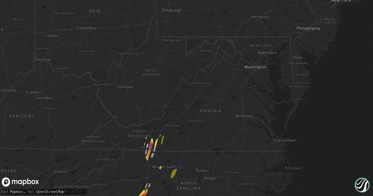
Hail Map in Virginia on April 15, 2018
Get this storm
April 15 map
$229
one time, instant access
Download today. No call, no setup
Keep the $229
Bought the map and want the full workflow? Apply the entire $229 to a subscription within 7 days. None of it is wasted.
Every map, not just this one
This buys you this map. Subscription and you get every map we run, in the markets you choose from a few cities to whole states to nationwide. Plus real-time alerts the moment a storm fires.
Contact data
Name, contact info, occupancy, even credit band for addresses in the footprint. You go from where it hit to who to call.
Become the source they trust
Unlimited branding weather history reports on demand. You already have the documented answer ready for the property owner, and you are the one who showed up with it.
Property data and RoofTrace estimates
Pull up any address you have got, its value and the exact code rules for that jurisdiction, straight from One Click Code. Then RoofTrace estimates the squares, pitch, and roof value, priced the way you price.
Storm reports in Virginia
Virginia
| Date | Description |
|---|---|
| 04/15/20186:57 PM CDT | Tree down on heards mountain road at hungry town road. |
| 04/15/20186:31 PM CDT | Tree down near the intersection of diggs mountain rd. And arrington rd. |
| 04/15/20186:31 PM CDT | Trees down near prospect. |
| 04/15/20186:30 PM CDT | Trees snapped and uprooted from gladstone to wingina. Some power line damage. Wind estimated 65 mph. |
| 04/15/20186:30 PM CDT | Large tree... 24 inches in diameter... Snapped off about 30 feet above the ground. It is a white pine tree. |
| 04/15/20186:20 PM CDT | *** 8 inj *** amherst county em very confident that a tornado occurred in the vicinity of elon road... Nottoway drive... Deerfield drive... And hunt club road in the el |
| 04/15/20186:20 PM CDT | Several trees down in gladstone. |
| 04/15/20186:18 PM CDT | Three trees down near the intersection of tye river rd. And us-60. |
| 04/15/20186:07 PM CDT | Spotters and volunteer fire dept visually confirmed tornado on timberlake road. Cars were flipped over... Several trees were downed and several structures damaged. Time |
| 04/15/20186:05 PM CDT | Trees down and minor damage to homes. |
| 04/15/20186:05 PM CDT | A tree was blown down by thunderstorm winds along the patrick henry highway. |
| 04/15/20186:01 PM CDT | Spotters and volunteer fire dept visually confirmed tornado on timberlake road. Cars were flipped over... Several trees were downed and several structures damaged. Time |
| 04/15/20186:01 PM CDT | Tree limbs down. Carport damaged. Tornado observed. |
| 04/15/20186:00 PM CDT | Two trees down on brattons run road. Time radar estimated. |
| 04/15/20186:00 PM CDT | *** 12 inj *** tornado with ef2 damage along a nearly continuous path of 20.4 miles... Began 37.326/-79.241... Ended 37.606/-79.163... From near timberlake va... To 5.5 |
| 04/15/20185:54 PM CDT | Tree down on tinkerville road. Time radar estimated. |
| 04/15/20185:54 PM CDT | Two trees down on brattons run road. |
| 04/15/20185:49 PM CDT | A tree was blown down by thunderstorm winds along the brookneal highway. |
| 04/15/20185:49 PM CDT | A tree was blown down by thunderstorm winds along whipping creek road. |
| 04/15/20185:42 PM CDT | Several trees were blown down around the community of halifax by thunderstorm winds. |
| 04/15/20185:35 PM CDT | Straight line winds produced isolated pockets of damage from burke road to just northeast of blue ridge drive... 2 miles northeast of gretna... Virginia. Three homes su |
| 04/15/20185:20 PM CDT | Debris of cattle barn in road |
| 04/15/20185:18 PM CDT | Trees downed on halifax road. |
| 04/15/20185:15 PM CDT | Trees down. Possible tornado |
| 04/15/20185:15 PM CDT | Tree down on power lines near woodlawn heights rd. Time estimate by radar. |
| 04/15/20185:10 PM CDT | Tornado of approximately 0.66 mile path length and 100 yard path width touched down on 1800 block of mead valley road at approximately 610 pm edt on april 15th... And l |
| 04/15/20185:02 PM CDT | Multiple trees down and power poles snapped at 1948 blair loop rd. Time estimated from radar. |
| 04/15/20185:00 PM CDT | Emergency manager confirms a tornado skipped through a path across pittsylvania and the city of danville resulting in considerable damage to 38 structures... Several of |
| 04/15/20185:00 PM CDT | Emergency management reported possible tornado damage to homes in several locations in the county including riverbend... Mt. Hermon and gretna areas. Time is estimated |
| 04/15/20184:58 PM CDT | Thunderstorm winds blew down the sign of a business and damaged the roof of a home along highway 58. Several trees were blown down as well. |
| 04/15/20184:57 PM CDT | Large limbs down. |
| 04/15/20184:57 PM CDT | Trees down. Possible tornado. Between westover drive and riverside drive. |
| 04/15/20184:57 PM CDT | 12 to 14 trees down. Possible tornado. |
| 04/15/20184:57 PM CDT | A large tree was blown down along beechtree court by thunderstorm winds. |
| 04/15/20184:56 PM CDT | Possible tornado. Numerous trees and power lines down. Damage to structures. |
| 04/15/20184:55 PM CDT | Numerous trees snapped off and down across the road near westover drive and church ave. Time estimated by radar. |
| 04/15/20184:54 PM CDT | Tornado with ef1 damage along a nearly continuous path of 12.0 miles from 4 miles sw of danville city to 2 miles sw of dry fork va... Passing through the west side of t |
| 04/15/20184:45 PM CDT | A powerline was blown down in the community of axton by thunderstorm winds. |
| 04/15/20184:35 PM CDT | At least 4 large trees were blown down by thunderstorm winds around the community of rocky mount. |
| 04/15/20184:03 PM CDT | Tornado with ef1 damage...estimated maximum winds of 105 mph...on the ground for less than one minute with path width of about 150 yards and path length of approximatel |
| 04/15/20183:59 PM CDT | Multiple buildings sustained damage by thunderstorm winds in the community of new castle. In addition... Several trees were blown down or snapped. |
| 04/15/20183:33 PM CDT | A local report indicates 1.00 inch wind near 6 SSW PILOT |
| 04/15/20183:15 PM CDT | Quarter sized hail near woolwine. |
| 04/15/20183:09 PM CDT | A local report indicates 1.00 inch wind near SE FLOYD |
| 04/15/20183:09 PM CDT | Several large limbs blown down. |
| 04/15/20182:36 PM CDT | At least 3 large trees were snapped or topped by strong thunderstorm winds. |
| 04/15/20182:06 PM CDT | Wdbj viewer photo of tennis ball sized hail in hillsville. Time estimated from radar. |
| 04/15/20182:01 PM CDT | A local report indicates 2.50 inch wind near 1 N FANCY GAP |
| 04/15/20182:00 PM CDT | Golfball size hail was observed along the fancy gap highway. |
| 04/15/20181:40 PM CDT | A tree was blown down by thunderstorm winds along coal creek road. |
| 04/15/20181:30 PM CDT | A large tree was blown down by thunderstorm winds along carsonville road. |
| 04/15/20186:23 AM CDT | At 1121 PM EDT, a line of severe thunderstorms stretched from near Lake Gaston south to Warrenton to Nashville, with individual thunderstorm cells moving north at 75 mph. HAZARD...60 mph wind gusts. SOURCE...Radar indicated. IMPACT...Expect damage to roofs, siding, and trees. Locations impacted include... Rocky Mount, Roanoke Rapids, Nashville, Warrenton, Halifax, Norlina, Dortches, Littleton, Red Oak and Enfield. |
| 04/15/20186:22 AM CDT | At 1122 PM EDT, a severe thunderstorm was located over Powhatan, moving north at 55 mph. HAZARD...60 mph wind gusts and penny size hail. SOURCE...Radar indicated. IMPACT...Expect damage to trees and powerlines. This severe thunderstorm will be near, Goochland and Sabot around 1130 PM EDT. Oilville and Gum Spring around 1135 PM EDT. Montpelier around 1145 PM EDT. Other locations impacted by this severe thunderstorm include Orchid,Goodwins Store, Flat Rock, Crozier, Sandy Hook, Oliver, Jefferson,Vontay, Maidens and Coatesville. |
| 04/15/20185:50 AM CDT | Trees down near carrsville. |
| 04/15/20185:22 AM CDT | At 1021 PM EDT, a line of severe thunderstorms stretched from near Kerr Lake to Oxford to Raleigh, with indivdual thunderstorm cells moving northeast at 80 mph. HAZARD...60 mph wind gusts. SOURCE...Radar indicated. IMPACT...Expect damage to roofs, siding, and trees. Locations impacted include... Raleigh, Henderson, Oxford, Louisburg, Warrenton, Wake Forest, Zebulon, Franklinton, Norlina and Bailey. |
| 04/15/20183:59 AM CDT | At 858 PM EDT, severe thunderstorms were located along a line extending from 6 miles south of Culpeper to near Louisa to Macon, moving northeast at 55 mph. HAZARD...60 mph wind gusts. SOURCE...Radar indicated. IMPACT...Expect damage to trees and powerlines. These severe thunderstorms will remain over mainly rural areas of Louisa...east central Cumberland...Goochland...north central Amelia and Powhatan Counties, including the following locations: Orchid, Rock Castle, Louisa Airport, Maidens, Three Square, Irwin, Michaux, West View, Tabscott and Othma. |
| 04/15/20183:47 AM CDT | Tree down and power lines down. |
| 04/15/20183:33 AM CDT | At 831 PM EDT, severe thunderstorms were located along a line extending from 8 miles southeast of Stanardsville to near Troy to Lakeside Village, moving north northeast at 50 mph. HAZARD...60 mph wind gusts and quarter size hail. SOURCE...Radar indicated. IMPACT...Damaging winds will cause some trees and large branches to fall. This could injure those outdoors, as well as damage homes and vehicles. Roadways may become blocked by downed trees. Localized power outages are possible. Unsecured light objects may become projectiles. Locations impacted include... Culpeper, Orange, Gordonsville, Brightwood, Mine Run, Stevensburg, Oakpark, Barboursville, Verdiersville, Everona, Montpelier Station, Locust Grove, Flat Run, Thornhill, Nasons, Winston, Madison Mills, Montford, Mitchells and Glenora. |
| 04/15/20183:30 AM CDT | At 830 PM EDT, severe thunderstorms were located along a line extending from near Boswells Tavern to near Ferncliff to near Lakeside Village, moving northeast at 55 mph. HAZARD...60 mph wind gusts and penny size hail. SOURCE...Radar indicated. IMPACT...Expect damage to trees and powerlines. Severe thunderstorms will be near, Kents Store around 845 PM EDT. Hadensville around 850 PM EDT. Other locations impacted by these severe thunderstorms include Dixie,Ashby, Oak Forest, Stage Junction, Clinton, Tamworth, Caledonia, ElkHill, Bybee and Whiteville. |
| 04/15/20183:24 AM CDT | At 823 PM EDT, a severe thunderstorm was located near Green Bay, or near Victoria, moving northeast at 60 mph. HAZARD...60 mph wind gusts. SOURCE...Radar indicated. IMPACT...Expect damage to trees and powerlines. This severe thunderstorm will be near, Burkeville around 830 PM EDT. Crewe and Rice around 835 PM EDT. Jetersville around 840 PM EDT. Amelia Courthouse and Morven around 850 PM EDT. Other locations impacted by this severe thunderstorm include RainesTavern, Prince Edward Station, Angola, Arvins Store, Twin Lakes StatePark, Nutbush, Hawk, Maplewood, Meherrin and Deatonville. |
| 04/15/20183:14 AM CDT | Asos station nfe... Naval auxilary landing field. |
| 04/15/20183:12 AM CDT | At 811 PM EDT, severe thunderstorms were located along a line extending from near Free Union to near Lake Monticello to Fork Union to near Cumberland, moving northeast at 45 mph. HAZARD...60 mph wind gusts and nickel size hail. SOURCE...Radar indicated. IMPACT...Expect damage to trees and powerlines. Locations impacted include... Louisa, Mineral, Ferncliff, Boswells Tavern, Gordonsville, Pendleton, Louisa Airport, Green Springs, Zion Crossroads, Cuckoo, Yanceyville, Waldrop, Byrd Mill, Trevilians, Wares Crossroads and Vawter Corner. |
| 04/15/20182:48 AM CDT | At 748 PM EDT, severe thunderstorms were located along a line extending from 7 miles northwest of Schuyler to near Centenary to Dillwyn to near Sheppards, moving northeast at 45 mph. HAZARD...60 mph wind gusts. SOURCE...Radar indicated. IMPACT...Expect damage to trees and powerlines. Locations impacted include... Cumberland, Farmville, Hadensville, Palmyra, Fork Union, Lake Monticello, Columbia, Guinea Mills, Lakeside Village, Kents Store, Troy, Fife, Sunnyside, Duncan, Scottsville, Angola, Central Plains, Bremo Bluff, Hawk and Whiteville. |
| 04/15/20182:47 AM CDT | At 747 PM EDT, severe thunderstorms were located along a line extending from Schuyler to near Buckingham to near Sheppards, moving northeast at 50 mph. HAZARD...60 mph wind gusts and quarter size hail. SOURCE...Radar indicated. IMPACT...Damaging winds will cause some trees and large branches to fall. This could injure those outdoors, as well as damage homes and vehicles. Roadways may become blocked by downed trees. Localized power outages are possible. Unsecured light objects may become projectiles. Locations impacted include... Charlottesville, Waynesboro, Crozet, Crimora, Schuyler, Free Union, Afton, Campbell, Westmoreland, Hollymead, Ivy, New Hope, Scottsville, Esmont, Hermitage, North Garden, Covesville, Yancey Mills, Stony Point and Flordon. |
| 04/15/20182:10 AM CDT | At 708 PM EDT, a line of severe thunderstorms were located along a line extending from near Goshen to Cornwall to near Madison Heights, moving north at 50 mph. HAZARD...60 mph wind gusts and quarter size hail. SOURCE...Radar indicated. IMPACT...Damaging winds will cause some trees and large branches to fall. This could injure those outdoors, as well as damage homes and vehicles. Roadways may become blocked by downed trees. Localized power outages are possible. Unsecured light objects may become projectiles. Locations impacted include... Staunton, Waynesboro, Stuarts Draft, Sherando, Shipman, Schuyler, Wintergreen, Montebello, Fishersville, Verona, Lyndhurst, Nellysford, Craigsville, Greenville, Arrington, Lovingston, Augusta Springs, Middlebrook, Churchville and Deerfield. |
| 04/15/20182:05 AM CDT | At 704 PM EDT, severe thunderstorms were located along a line extending from near Boonsboro to Concord to near Red House to Clover, moving northeast at 50 mph. HAZARD...60 mph wind gusts. SOURCE...Radar indicated. IMPACT...Expect damage to trees and powerlines. Locations impacted include... Farmville, Hampden Sydney College, Longwood University, Hampden Sydney, Darlington Heights, Prospect, Briery Creek Lake, Tuggle, Briery, Allens Mill, Kingsville, Elam and Worsham. |
| 04/15/20181:55 AM CDT | Trees down along kings way. |
| 04/15/20181:50 AM CDT | Corrects previous tstm wnd dmg report from 2 ne carrsville. Trees down near carrsville. |
| 04/15/20181:47 AM CDT | Trees down near king and queen courthouse. |
| 04/15/20181:47 AM CDT | At 647 PM EDT, severe thunderstorms were located along a line extending from near Timberlake to Mt Laurel, moving northeast at 70 mph. HAZARD...60 mph wind gusts and quarter size hail. SOURCE...Radar indicated. IMPACT...Hail damage to vehicles is expected. Expect wind damage to roofs, siding, and trees. Locations impacted include... Lynchburg... Buckingham... Altavista... Amherst... and Appomattox.This includes The following Locations Liberty University andLynchburg Airport. |
| 04/15/20181:35 AM CDT | Trees down along homestead rd. |
| 04/15/20181:25 AM CDT | Tree down along rt 60. |
| 04/15/20181:12 AM CDT | At 611 PM EDT, a severe thunderstorm was located near Chamblissburg, moving northeast at 50 mph. HAZARD...60 mph wind gusts and quarter size hail. SOURCE...Radar indicated. IMPACT...Hail damage to vehicles is expected. Expect wind damage to roofs, siding, and trees. Locations impacted include... Lexington... Buena Vista... Bedford... Buchanan... and Glasgow.This includes The following Locations VMI and The National D-DayMemorial. |
| 04/15/20181:01 AM CDT | Tree down near the intersection of tetotum road and stony point road. |
| 04/15/20181:00 AM CDT | Tree down on caledon road. |
| 04/14/201811:08 PM CDT | At 407 PM EDT, a severe thunderstorm was located near Mocksville, moving northeast at 65 mph. HAZARD...60 mph wind gusts and quarter size hail. SOURCE...Radar indicated. IMPACT...Hail damage to vehicles is expected. Expect wind damage to roofs, siding, and trees. Locations impacted include... Martinsville... Mount Airy... Flat Rock... Yadkinville... and Mayodan.This includes The following Location Martinsville Airport. |
| 04/14/201810:57 PM CDT | At 356 PM EDT, a severe thunderstorm was located near Copper Valley, moving north at 60 mph. HAZARD...60 mph wind gusts and quarter size hail. SOURCE...Radar indicated. IMPACT...Hail damage to vehicles is expected. Expect wind damage to roofs, siding, and trees. Locations impacted include... Roanoke... Blacksburg... Salem... Christiansburg... and Radford.This includes The following Locations Virginia Tech, The SalemFairgrounds, and Roanoke Regional Airport. |
| 04/14/20189:45 PM CDT | Downed tree reported by amelia county 911 center. |
| 04/14/20189:15 PM CDT | Corrects date from previous tstm wnd dmg report from 3 wsw clay store. Roof removed from an old and rotted wooden shed. Damage consistent with straight line winds. |
| 04/14/20189:13 PM CDT | Trees down on piney green rd. Consistent with straightline winds. |
| 04/14/20189:12 PM CDT | At 211 PM EDT, a severe thunderstorm was located over Swancreek, moving north at 55 mph. HAZARD...60 mph wind gusts and quarter size hail. SOURCE...Radar indicated. IMPACT...Hail damage to vehicles is expected. Expect wind damage to roofs, siding, and trees. Locations impacted include... Mount Airy... Elkin... Fairview... Flat Rock... and Jonesville. |
| 04/14/20189:02 PM CDT | Trees snapped/uprooted. Possible tornado damage. |
| 04/14/20188:56 PM CDT | Trees down along e third st in kenbridge. |
| 04/14/20188:50 PM CDT | Several trees down across the southwestern part of spotsylvania county. |
| 04/14/20188:36 PM CDT | At 135 PM EDT, a severe thunderstorm was located over Cedar Rock, moving north at 50 mph. HAZARD...60 mph wind gusts. SOURCE...Radar indicated. IMPACT...Expect damage to roofs, siding, and trees. Locations impacted include... Galax... North Wilkesboro... Wilkesboro... Sparta... and Independence. |
| 04/14/20188:00 PM CDT | Downed tree on road reported by police officer. Time is approximate/estimated by radar. |
| 04/14/20187:42 PM CDT | Trees down along slayer creek rd. |
| 04/14/20187:41 PM CDT | Trees down along highway 49. |
| 04/14/20187:30 PM CDT | Downed tree reported on miller lane. Time is approximate/estimated by radar. |
All States Impacted by Hail Map on April 15, 2018
Cities Impacted by Hail Map on April 15, 2018
- Max Meadows, VA
- Hillsville, VA
- Fancy Gap, VA
- Dugspur, VA
- Laurel Fork, VA
- Willis, VA
- Enoree, SC
- Mooresville, NC
- Cornelius, NC
- Galax, VA
- Ararat, VA
- Fort Pierce, FL
- McAdenville, NC
- Gastonia, NC
- Mount Holly, NC
- Belmont, NC
- Clover, SC
- Lowell, NC
- Stanley, NC
- Cramerton, NC
- York, SC
- Charlotte, NC
- Dobson, NC
- Lowgap, NC
- Cana, VA
- Elkin, NC
- State Road, NC
- Woodlawn, VA
- Lambsburg, VA
- Hiwassee, VA
- Thurmond, NC
- Mount Airy, NC
- Woodbine, GA
- Huntersville, NC
- Smyrna, SC
- Sharon, SC
- Austinville, VA
- Vero Beach, FL
- Fries, VA
- Clemmons, NC
- Winston Salem, NC
- Lewisville, NC
- Davidson, NC
- Mount Ulla, NC
- Kingsland, GA
- Woodruff, SC
- Pauline, SC
- Laurens, SC
- Spartanburg, SC
- Pacolet, SC
- Waterloo, SC
- Greenwood, SC
- Hodges, SC
- Woolwine, VA
- Meadows Of Dan, VA
- Floyd, VA
- Riner, VA
- Pilot, VA
- High Point, NC
- Trinity, NC
- Jamestown, NC
- Greensboro, NC
- Randleman, NC
- Sophia, NC
- Browns Summit, NC
- Tallahassee, FL
- Crawfordville, FL
- Greenville, FL
- O'Brien, FL


