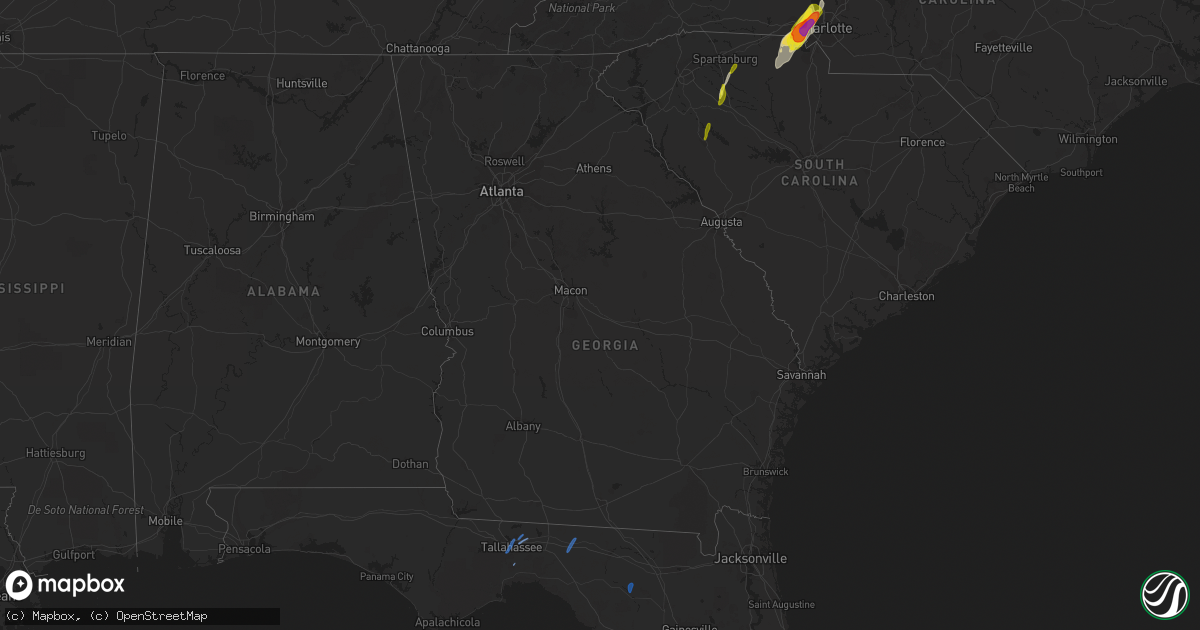
Hail Map in Georgia on April 15, 2018
Get this storm
April 15 map
$229
one time, instant access
Download today. No call, no setup
Keep the $229
Bought the map and want the full workflow? Apply the entire $229 to a subscription within 7 days. None of it is wasted.
Every map, not just this one
This buys you this map. Subscription and you get every map we run, in the markets you choose from a few cities to whole states to nationwide. Plus real-time alerts the moment a storm fires.
Contact data
Name, contact info, occupancy, even credit band for addresses in the footprint. You go from where it hit to who to call.
Become the source they trust
Unlimited branding weather history reports on demand. You already have the documented answer ready for the property owner, and you are the one who showed up with it.
Property data and RoofTrace estimates
Pull up any address you have got, its value and the exact code rules for that jurisdiction, straight from One Click Code. Then RoofTrace estimates the squares, pitch, and roof value, priced the way you price.
Storm reports in Georgia
Georgia
| Date | Description |
|---|---|
| 04/15/20182:00 PM CDT | Report of tornado near harrietts bluff. Several trees uprooted. |
| 04/15/20182:00 PM CDT | Corrects previous tornado report from harrietts bluff. Report of a tree down in back yard. It has been determined there was no tornado. |
| 04/15/201812:45 PM CDT | Screven county 911 center reported a tree blown down along pine grove inn road. Time of event was estimated from radar. |
| 04/15/201812:22 PM CDT | Bulloch county 911 center reported a tree and a power line blown down along west lee street in brooklet. Time of event was estimated from radar. |
| 04/15/201812:22 PM CDT | Bulloch county 911 center reported a tree blown down along u.s. Highway 80 just east of brooklet. Time of event was estimated from radar. |
| 04/15/201812:00 PM CDT | Tree down along south macon street in jesup. Time given was based on radar |
| 04/15/201811:49 AM CDT | Law enforcement reports tree down on power lines on hollis road. |
| 04/15/201811:47 AM CDT | Power lines down on anne street. |
| 04/15/201810:53 AM CDT | Tree reported down on rabbit run rd. At the intersection with morris rd. The tree also brought down power lines. |
| 04/15/20189:25 AM CDT | Tree down blocking a road in ben hill county. |
| 04/15/20189:15 AM CDT | Tree down on chaserville road. |
| 04/15/20189:10 AM CDT | Tree down on ferry lake road. |
| 04/15/20189:03 AM CDT | Stop light blown off line on 319 on the east side of tifton. |
| 04/15/20189:00 AM CDT | Trees down in troupville. |
| 04/15/20188:55 AM CDT | Tree down in adel. |
| 04/15/20188:54 AM CDT | Tree down at mitchell store road and omega-eldorado road. |
| 04/15/20188:50 AM CDT | 2 trees down on antioch road. |
| 04/15/20188:42 AM CDT | 2 trees down along tillman road. |
| 04/15/20188:36 AM CDT | Trees down along hamlin road. |
| 04/15/20188:24 AM CDT | Trees down along dixie barwick road. |
| 04/15/20188:18 AM CDT | Tree down along bay road. |
| 04/15/20188:06 AM CDT | Several trees down along 319s and metcalf road. |
| 04/15/20187:55 AM CDT | Brief ef1 tornado with trees snapped and uprooted in different directions. Max winds estimated at 90-95 mph. Path length 0.46 miles and width 31 yards. |
| 04/15/20187:46 AM CDT | Trees and power lines across the county. Some locations include orange and barber streets. |
| 04/15/20187:40 AM CDT | Trees down from straight line winds. |
| 04/15/20187:40 AM CDT | Trees down from straight line winds. |
| 04/15/20187:10 AM CDT | At 1210 PM EDT, severe thunderstorms were located along a line extending from Swainsboro to near Aline to near Plant Hatch, moving northeast at 40 mph. HAZARD...60 mph wind gusts. SOURCE...Radar indicated. IMPACT...Expect damage to roofs, siding, and trees. Locations impacted include... Swainsboro, Twin City, Stillmore, Oak Park, Garfield, Nunez, Modoc, Canoochee, Lexsy and George L Smith State Park. |
| 04/15/20186:56 AM CDT | At 1156 AM EDT, severe thunderstorms were located along a line extending from near Uvalda to near Baxley to near Pebble Hill, moving northeast at 50 mph. HAZARD...60 mph wind gusts. SOURCE...Radar indicated. IMPACT...Expect damage to roofs, siding, and trees. Locations impacted include... Baxley, Alma, Blackshear, Patterson, Graham, Surrency, Plant Hatch, Screven, Odum and Offerman. |
| 04/15/20186:51 AM CDT | At 1151 AM EDT, severe thunderstorms were located along a line extending from near Kibbee to near Vidalia to South Thompson to near Plant Hatch to near New Lacy, moving northeast at 50 mph. HAZARD...60 mph wind gusts. SOURCE...Radar indicated. IMPACT...Expect damage to roofs, siding, and trees. Locations impacted include... Lyons, Vidalia, Stillmore, Oak Park, Higgston, Santa Claus, Center, Toombs Central, Ohoopee, New Branch, Ponderosa, Kibbee, South Thompson, English Eddy, Rock Springs, Cedar Crossing, Lexsy, Johnson Corner, Normantown and Grays Landing. |
| 04/15/20186:18 AM CDT | At 1117 AM EDT, severe thunderstorms were located along a line extending from near Horse Creek Wma to near Snipesville to Denton to near Nicholls, moving northeast at 50 mph. HAZARD...60 mph wind gusts. SOURCE...Radar indicated. IMPACT...Expect damage to roofs, siding, and trees. Locations impacted include... Lyons, Alamo, Mount Vernon, Vidalia, Lumber City, Glenwood, Uvalda, Ailey, Scotland, Higgston, Santa Claus, Alston, Tarrytown, Towns, Horse Creek Wma, Spring Hill, McNatt Falls, South Thompson, Cedar Crossing and Jordan. |
| 04/15/20186:15 AM CDT | At 1115 AM EDT, severe thunderstorms were located along a line extending from 9 miles east of Jacksonville to near Snipesville to near Cogdell, moving northeast at 60 mph. HAZARD...60 mph wind gusts. SOURCE...Radar indicated. IMPACT...Expect damage to roofs, siding, and trees. Locations impacted include... Baxley, Hazlehurst, Alma, Graham, Plant Hatch, Nicholls, Snipesville, Denton, New Lacy and Pine Grove. |
| 04/15/20186:13 AM CDT | At 1112 AM EDT, severe thunderstorms were located along a line extending from near Homerville to near Jasper to 13 miles south of Mayo, moving northeast at 40 mph. HAZARD...60 mph wind gusts. SOURCE...Radar indicated. IMPACT...Expect damage to roofs, siding, and trees. Locations impacted include... Live Oak, Homerville, White Springs, Fargo, Argyle, Ichetucknee Spring, Suwannee Springs, Pebble Hill, Winfield and Suwannee Valley. |
| 04/15/20185:26 AM CDT | At 1026 AM EDT, a severe thunderstorm was located near Dooling, or 10 miles east of Oglethorpe, moving northeast at 40 mph. HAZARD...60 mph wind gusts. SOURCE...Radar indicated. IMPACT...Expect damage to roofs, siding, and trees. Locations impacted include... Perry, Warner Robins, Unadilla, Robins Air Force Base, Hayneville, Meadowdale, Sand Bed, Houston Lake, Grovania, Elko, Grove Park, Moss Oak, Elberta, Bonaire, Henderson, Kathleen and Clinchfield. |
| 04/15/20185:14 AM CDT | At 1013 AM EDT, severe thunderstorms were located along a line extending from near Mystic to near Alapaha to near Moody Air Force Base, moving northeast at 45 mph. HAZARD...60 mph wind gusts. SOURCE...Radar indicated. IMPACT...Expect damage to roofs, siding, and trees. Locations impacted include... Douglas, Pearson, Willacoochee, Broxton, Ambrose, Pridgen, West Green, Snipesville, Denton and Axson. |
| 04/15/20185:11 AM CDT | At 1011 AM EDT, severe thunderstorms were located along a line extending from near Enigma to near Blue Springs, moving east at 30 mph. HAZARD...60 mph wind gusts. SOURCE...Radar indicated. IMPACT...Expect damage to roofs, siding, and trees. Locations impacted include... Mayo, Lake Park, Nashville, Lakeland, Valdosta, Ray City, Alapaha, Moody Air Force Base, Meigs, Dasher, Lee, Barretts, New Lois, Glory, Buckville, Hansell, Allenville, Weber, I-75 At Exit 11 and San Pedro Junction. |
| 04/15/20185:09 AM CDT | At 1009 AM EDT, severe thunderstorms were located along a line extending from near Valdosta to 7 miles northwest of Blue Springs to 7 miles east of Perry, moving northeast at 40 mph. HAZARD...60 mph wind gusts. SOURCE...Radar indicated. IMPACT...Expect damage to roofs, siding, and trees. Locations impacted include... Live Oak, Jasper, Homerville, Jennings, Statenville, Suwannee River State Park, Suwannee Springs, Du Pont, Mayday and Crossroads. |
| 04/15/20185:03 AM CDT | At 1003 AM EDT, a severe thunderstorm was located near Unionville, or near Tifton, moving northeast at 60 mph. HAZARD...60 mph wind gusts. SOURCE...Radar indicated. IMPACT...Expect damage to roofs, siding, and trees. Locations impacted include... Fitzgerald, Tifton, Ocilla, Enigma, Alapaha, Mystic, Unionville, Phillipsburg, Sycamore, Rebecca, Eldorado, Gladys, Osierfield, Harding, Waterloo, Pinetta, Inaha, Ashton, Irwinville and Irwinville Airport. |
| 04/15/20184:11 AM CDT | At 911 AM EDT, severe thunderstorms were located along a line extending from near Coolidge to 11 miles southeast of Monticello to 15 miles southwest of Perry, moving east at 30 mph. HAZARD...60 mph wind gusts. SOURCE...Radar indicated. IMPACT...Expect damage to roofs, siding, and trees. Locations impacted include... Monticello, Perry, Thomasville, Quitman, Madison, Boston, Pavo, Coolidge, Greenville, Barwick, Alma, Pinland, Jug Island, Dillon, Everett, Merrillville, Drifton, Scanlon, Lovett and Empress. |
| 04/15/20183:48 AM CDT | At 848 AM EDT, severe thunderstorms were located along a line extending from 9 miles southwest of Thomasville to near Woodville, moving east at 45 mph. HAZARD...60 mph wind gusts. SOURCE...Radar indicated. IMPACT...Expect damage to roofs, siding, and trees. Locations impacted include... Monticello, Thomasville, Cairo, Quitman, Woodville, Tallahassee, Boston, Ochlocknee, Pavo, Coolidge, Greenville, Morven, Barwick, Alma, Cody, Capel, Dillon, Everett, Rocky Hill and Miccosukee. |
| 04/14/201810:23 PM CDT | At 322 PM EDT, a severe thunderstorm was located near Waverly, or 7 miles southwest of Dock Junction, moving northeast at 55 mph. HAZARD...60 mph wind gusts and penny size hail. SOURCE...Radar indicated. IMPACT...Expect damage to roofs, siding, and trees. Locations impacted include... Brunswick, St. Simons Island, Dock Junction, Country Club Estates, Waverly, Sea Island, Jekyll Island and Boys Estate. |
| 04/14/20189:45 PM CDT | At 245 PM EDT, severe thunderstorms were located along a line extending from Bryceville to Cecil Field to near Interlachen, moving northeast at 50 mph. HAZARD...70 mph wind gusts. SOURCE...Radar indicated. IMPACT...Expect considerable tree damage. Damage is likely to mobile homes, roofs, and outbuildings. Locations impacted include... Jacksonville, Orange Park, Green Cove Springs, Hilliard, Callahan, Jacksonville International Arpt, Mandarin, Fruit Cove, Arlington and Middleburg. |
| 04/14/20189:34 PM CDT | At 234 PM EDT, a severe thunderstorm was located near Woodbine, moving northeast at 35 mph. HAZARD...60 mph wind gusts. SOURCE...Radar indicated. IMPACT...Expect damage to roofs, siding, and trees. Locations impacted include... Brunswick, St. Simons Island, Woodbine, Dock Junction, Country Club Estates, Waverly, Sea Island, Jekyll Island, Boys Estate and Dover Bluff. |
| 04/14/20189:26 PM CDT | At 226 PM EDT, a severe thunderstorm was located 7 miles east of Gardi, moving northeast at 50 mph. HAZARD...60 mph wind gusts and nickel size hail. SOURCE...Radar indicated. IMPACT...Expect damage to trees and powerlines. Locations impacted include... Hinesville, Richmond Hill, Tibet, Fort Stewart, Jones, McIntosh, Walthourville and Riceboro.This warning includes I-95 in Georgia between mile markers 62 and 93. |
| 04/14/20189:16 PM CDT | At 216 PM EDT, a severe thunderstorm was located over Sampson, or 7 miles southwest of Starke, moving northeast at 45 mph. HAZARD...60 mph wind gusts. SOURCE...Radar indicated. IMPACT...Expect damage to roofs, siding, and trees. Locations impacted include... Starke, Keystone Heights, Melrose, Middleburg, Macclenny, Glen St. Mary, Maxville, Oakleaf Plantation, Lake Geneva and Bryceville. |
| 04/14/20189:15 PM CDT | At 214 PM EDT, a severe thunderstorm was located 7 miles north of Waynesville, or 13 miles northeast of Nahunta, moving northeast at 45 mph. HAZARD...60 mph wind gusts and quarter size hail. SOURCE...Radar indicated. IMPACT...Hail damage to vehicles is expected. Expect wind damage to roofs, siding, and trees. Locations impacted include... Jesup, Gardi, Thalmann, Everett, Waynesville, Atkinson and Mount Pleasant. |
| 04/14/20188:12 PM CDT | At 112 PM EDT, severe thunderstorms were located along a line extending from near Jackson to near Savannah River Site to 6 miles northeast of Sardis, moving northeast at 50 mph. HAZARD...60 mph wind gusts. SOURCE...Radar indicated. IMPACT...Expect damage to roofs, siding, and trees. Locations impacted include... Aiken, Barnwell, Savannah River Site, Williston, Blackville, New Ellenton, Jackson, Hilda, Snelling, Elko, Girard and Windsor.This includes Interstate 20 in South Carolina between mile markers 24and 29. |
All States Impacted by Hail Map on April 15, 2018
Cities Impacted by Hail Map on April 15, 2018
- Max Meadows, VA
- Hillsville, VA
- Fancy Gap, VA
- Dugspur, VA
- Laurel Fork, VA
- Willis, VA
- Enoree, SC
- Mooresville, NC
- Cornelius, NC
- Galax, VA
- Ararat, VA
- Fort Pierce, FL
- McAdenville, NC
- Gastonia, NC
- Mount Holly, NC
- Belmont, NC
- Clover, SC
- Lowell, NC
- Stanley, NC
- Cramerton, NC
- York, SC
- Charlotte, NC
- Dobson, NC
- Lowgap, NC
- Cana, VA
- Elkin, NC
- State Road, NC
- Woodlawn, VA
- Lambsburg, VA
- Hiwassee, VA
- Thurmond, NC
- Mount Airy, NC
- Woodbine, GA
- Huntersville, NC
- Smyrna, SC
- Sharon, SC
- Austinville, VA
- Vero Beach, FL
- Fries, VA
- Clemmons, NC
- Winston Salem, NC
- Lewisville, NC
- Davidson, NC
- Mount Ulla, NC
- Kingsland, GA
- Woodruff, SC
- Pauline, SC
- Laurens, SC
- Spartanburg, SC
- Pacolet, SC
- Waterloo, SC
- Greenwood, SC
- Hodges, SC
- Woolwine, VA
- Meadows Of Dan, VA
- Floyd, VA
- Riner, VA
- Pilot, VA
- High Point, NC
- Trinity, NC
- Jamestown, NC
- Greensboro, NC
- Randleman, NC
- Sophia, NC
- Browns Summit, NC
- Tallahassee, FL
- Crawfordville, FL
- Greenville, FL
- O'Brien, FL


