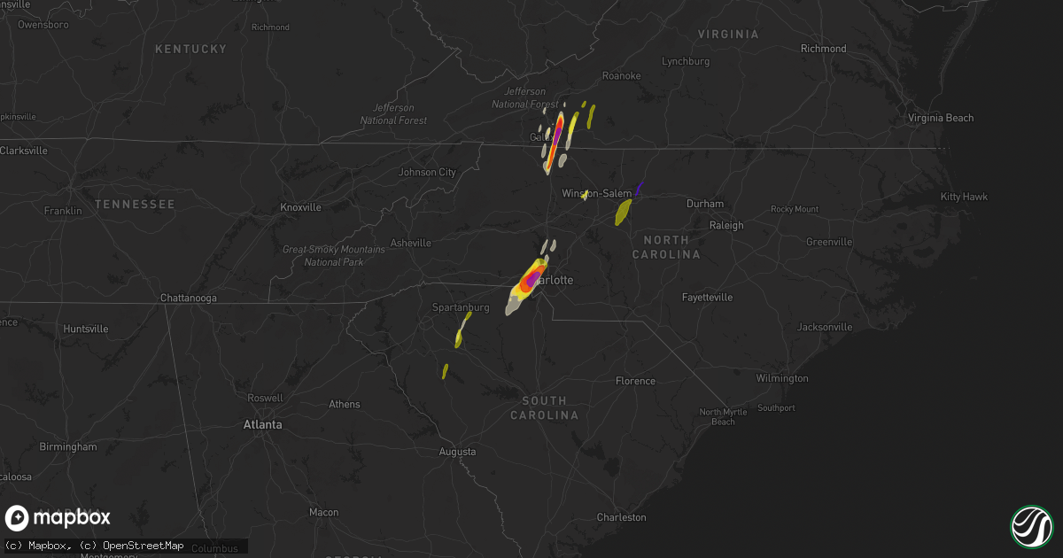
Hail Map on April 15, 2018
Get this storm
April 15 map
$229
one time, instant access
Download today. No call, no setup
Keep the $229
Bought the map and want the full workflow? Apply the entire $229 to a subscription within 7 days. None of it is wasted.
Every map, not just this one
This buys you this map. Subscription and you get every map we run, in the markets you choose from a few cities to whole states to nationwide. Plus real-time alerts the moment a storm fires.
Contact data
Name, contact info, occupancy, even credit band for addresses in the footprint. You go from where it hit to who to call.
Become the source they trust
Unlimited branding weather history reports on demand. You already have the documented answer ready for the property owner, and you are the one who showed up with it.
Property data and RoofTrace estimates
Pull up any address you have got, its value and the exact code rules for that jurisdiction, straight from One Click Code. Then RoofTrace estimates the squares, pitch, and roof value, priced the way you price.
States Impacted by Hail Map on April 15, 2018
Storm reports
Virginia
| Date | Description |
|---|---|
| 04/15/20186:57 PM CDT | Tree down on heards mountain road at hungry town road. |
| 04/15/20186:31 PM CDT | Tree down near the intersection of diggs mountain rd. And arrington rd. |
| 04/15/20186:31 PM CDT | Trees down near prospect. |
| 04/15/20186:30 PM CDT | Large tree... 24 inches in diameter... Snapped off about 30 feet above the ground. It is a white pine tree. |
| 04/15/20186:30 PM CDT | Trees snapped and uprooted from gladstone to wingina. Some power line damage. Wind estimated 65 mph. |
| 04/15/20186:20 PM CDT | Several trees down in gladstone. |
| 04/15/20186:20 PM CDT | *** 8 inj *** amherst county em very confident that a tornado occurred in the vicinity of elon road... Nottoway drive... Deerfield drive... And hunt club road in the el |
| 04/15/20186:18 PM CDT | Three trees down near the intersection of tye river rd. And us-60. |
| 04/15/20186:07 PM CDT | Spotters and volunteer fire dept visually confirmed tornado on timberlake road. Cars were flipped over... Several trees were downed and several structures damaged. Time |
| 04/15/20186:05 PM CDT | Trees down and minor damage to homes. |
| 04/15/20186:05 PM CDT | A tree was blown down by thunderstorm winds along the patrick henry highway. |
| 04/15/20186:01 PM CDT | Tree limbs down. Carport damaged. Tornado observed. |
| 04/15/20186:01 PM CDT | Spotters and volunteer fire dept visually confirmed tornado on timberlake road. Cars were flipped over... Several trees were downed and several structures damaged. Time |
| 04/15/20186:00 PM CDT | Two trees down on brattons run road. Time radar estimated. |
| 04/15/20186:00 PM CDT | *** 12 inj *** tornado with ef2 damage along a nearly continuous path of 20.4 miles... Began 37.326/-79.241... Ended 37.606/-79.163... From near timberlake va... To 5.5 |
| 04/15/20185:54 PM CDT | Tree down on tinkerville road. Time radar estimated. |
| 04/15/20185:54 PM CDT | Two trees down on brattons run road. |
| 04/15/20185:49 PM CDT | A tree was blown down by thunderstorm winds along whipping creek road. |
| 04/15/20185:49 PM CDT | A tree was blown down by thunderstorm winds along the brookneal highway. |
| 04/15/20185:42 PM CDT | Several trees were blown down around the community of halifax by thunderstorm winds. |
| 04/15/20185:35 PM CDT | Straight line winds produced isolated pockets of damage from burke road to just northeast of blue ridge drive... 2 miles northeast of gretna... Virginia. Three homes su |
| 04/15/20185:20 PM CDT | Debris of cattle barn in road |
| 04/15/20185:18 PM CDT | Trees downed on halifax road. |
| 04/15/20185:15 PM CDT | Tree down on power lines near woodlawn heights rd. Time estimate by radar. |
| 04/15/20185:15 PM CDT | Trees down. Possible tornado |
| 04/15/20185:10 PM CDT | Tornado of approximately 0.66 mile path length and 100 yard path width touched down on 1800 block of mead valley road at approximately 610 pm edt on april 15th... And l |
| 04/15/20185:02 PM CDT | Multiple trees down and power poles snapped at 1948 blair loop rd. Time estimated from radar. |
| 04/15/20185:00 PM CDT | Emergency management reported possible tornado damage to homes in several locations in the county including riverbend... Mt. Hermon and gretna areas. Time is estimated |
| 04/15/20185:00 PM CDT | Emergency manager confirms a tornado skipped through a path across pittsylvania and the city of danville resulting in considerable damage to 38 structures... Several of |
| 04/15/20184:58 PM CDT | Thunderstorm winds blew down the sign of a business and damaged the roof of a home along highway 58. Several trees were blown down as well. |
| 04/15/20184:57 PM CDT | A large tree was blown down along beechtree court by thunderstorm winds. |
| 04/15/20184:57 PM CDT | 12 to 14 trees down. Possible tornado. |
| 04/15/20184:57 PM CDT | Large limbs down. |
| 04/15/20184:57 PM CDT | Trees down. Possible tornado. Between westover drive and riverside drive. |
| 04/15/20184:56 PM CDT | Possible tornado. Numerous trees and power lines down. Damage to structures. |
| 04/15/20184:55 PM CDT | Numerous trees snapped off and down across the road near westover drive and church ave. Time estimated by radar. |
| 04/15/20184:54 PM CDT | Tornado with ef1 damage along a nearly continuous path of 12.0 miles from 4 miles sw of danville city to 2 miles sw of dry fork va... Passing through the west side of t |
| 04/15/20184:45 PM CDT | A powerline was blown down in the community of axton by thunderstorm winds. |
| 04/15/20184:35 PM CDT | At least 4 large trees were blown down by thunderstorm winds around the community of rocky mount. |
| 04/15/20184:03 PM CDT | Tornado with ef1 damage...estimated maximum winds of 105 mph...on the ground for less than one minute with path width of about 150 yards and path length of approximatel |
| 04/15/20183:59 PM CDT | Multiple buildings sustained damage by thunderstorm winds in the community of new castle. In addition... Several trees were blown down or snapped. |
| 04/15/20183:33 PM CDT | A local report indicates 1.00 inch wind near 6 SSW PILOT |
| 04/15/20183:15 PM CDT | Quarter sized hail near woolwine. |
| 04/15/20183:09 PM CDT | A local report indicates 1.00 inch wind near SE FLOYD |
| 04/15/20183:09 PM CDT | Several large limbs blown down. |
| 04/15/20182:36 PM CDT | At least 3 large trees were snapped or topped by strong thunderstorm winds. |
| 04/15/20182:06 PM CDT | Wdbj viewer photo of tennis ball sized hail in hillsville. Time estimated from radar. |
| 04/15/20182:01 PM CDT | A local report indicates 2.50 inch wind near 1 N FANCY GAP |
| 04/15/20182:00 PM CDT | Golfball size hail was observed along the fancy gap highway. |
| 04/15/20181:40 PM CDT | A tree was blown down by thunderstorm winds along coal creek road. |
| 04/15/20181:30 PM CDT | A large tree was blown down by thunderstorm winds along carsonville road. |
| 04/15/20186:23 AM CDT | At 1121 PM EDT, a line of severe thunderstorms stretched from near Lake Gaston south to Warrenton to Nashville, with individual thunderstorm cells moving north at 75 mph. HAZARD...60 mph wind gusts. SOURCE...Radar indicated. IMPACT...Expect damage to roofs, siding, and trees. Locations impacted include... Rocky Mount, Roanoke Rapids, Nashville, Warrenton, Halifax, Norlina, Dortches, Littleton, Red Oak and Enfield. |
| 04/15/20186:22 AM CDT | At 1122 PM EDT, a severe thunderstorm was located over Powhatan, moving north at 55 mph. HAZARD...60 mph wind gusts and penny size hail. SOURCE...Radar indicated. IMPACT...Expect damage to trees and powerlines. This severe thunderstorm will be near, Goochland and Sabot around 1130 PM EDT. Oilville and Gum Spring around 1135 PM EDT. Montpelier around 1145 PM EDT. Other locations impacted by this severe thunderstorm include Orchid,Goodwins Store, Flat Rock, Crozier, Sandy Hook, Oliver, Jefferson,Vontay, Maidens and Coatesville. |
| 04/15/20185:50 AM CDT | Trees down near carrsville. |
| 04/15/20185:22 AM CDT | At 1021 PM EDT, a line of severe thunderstorms stretched from near Kerr Lake to Oxford to Raleigh, with indivdual thunderstorm cells moving northeast at 80 mph. HAZARD...60 mph wind gusts. SOURCE...Radar indicated. IMPACT...Expect damage to roofs, siding, and trees. Locations impacted include... Raleigh, Henderson, Oxford, Louisburg, Warrenton, Wake Forest, Zebulon, Franklinton, Norlina and Bailey. |
| 04/15/20183:59 AM CDT | At 858 PM EDT, severe thunderstorms were located along a line extending from 6 miles south of Culpeper to near Louisa to Macon, moving northeast at 55 mph. HAZARD...60 mph wind gusts. SOURCE...Radar indicated. IMPACT...Expect damage to trees and powerlines. These severe thunderstorms will remain over mainly rural areas of Louisa...east central Cumberland...Goochland...north central Amelia and Powhatan Counties, including the following locations: Orchid, Rock Castle, Louisa Airport, Maidens, Three Square, Irwin, Michaux, West View, Tabscott and Othma. |
| 04/15/20183:47 AM CDT | Tree down and power lines down. |
| 04/15/20183:33 AM CDT | At 831 PM EDT, severe thunderstorms were located along a line extending from 8 miles southeast of Stanardsville to near Troy to Lakeside Village, moving north northeast at 50 mph. HAZARD...60 mph wind gusts and quarter size hail. SOURCE...Radar indicated. IMPACT...Damaging winds will cause some trees and large branches to fall. This could injure those outdoors, as well as damage homes and vehicles. Roadways may become blocked by downed trees. Localized power outages are possible. Unsecured light objects may become projectiles. Locations impacted include... Culpeper, Orange, Gordonsville, Brightwood, Mine Run, Stevensburg, Oakpark, Barboursville, Verdiersville, Everona, Montpelier Station, Locust Grove, Flat Run, Thornhill, Nasons, Winston, Madison Mills, Montford, Mitchells and Glenora. |
| 04/15/20183:30 AM CDT | At 830 PM EDT, severe thunderstorms were located along a line extending from near Boswells Tavern to near Ferncliff to near Lakeside Village, moving northeast at 55 mph. HAZARD...60 mph wind gusts and penny size hail. SOURCE...Radar indicated. IMPACT...Expect damage to trees and powerlines. Severe thunderstorms will be near, Kents Store around 845 PM EDT. Hadensville around 850 PM EDT. Other locations impacted by these severe thunderstorms include Dixie,Ashby, Oak Forest, Stage Junction, Clinton, Tamworth, Caledonia, ElkHill, Bybee and Whiteville. |
| 04/15/20183:24 AM CDT | At 823 PM EDT, a severe thunderstorm was located near Green Bay, or near Victoria, moving northeast at 60 mph. HAZARD...60 mph wind gusts. SOURCE...Radar indicated. IMPACT...Expect damage to trees and powerlines. This severe thunderstorm will be near, Burkeville around 830 PM EDT. Crewe and Rice around 835 PM EDT. Jetersville around 840 PM EDT. Amelia Courthouse and Morven around 850 PM EDT. Other locations impacted by this severe thunderstorm include RainesTavern, Prince Edward Station, Angola, Arvins Store, Twin Lakes StatePark, Nutbush, Hawk, Maplewood, Meherrin and Deatonville. |
| 04/15/20183:14 AM CDT | Asos station nfe... Naval auxilary landing field. |
| 04/15/20183:12 AM CDT | At 811 PM EDT, severe thunderstorms were located along a line extending from near Free Union to near Lake Monticello to Fork Union to near Cumberland, moving northeast at 45 mph. HAZARD...60 mph wind gusts and nickel size hail. SOURCE...Radar indicated. IMPACT...Expect damage to trees and powerlines. Locations impacted include... Louisa, Mineral, Ferncliff, Boswells Tavern, Gordonsville, Pendleton, Louisa Airport, Green Springs, Zion Crossroads, Cuckoo, Yanceyville, Waldrop, Byrd Mill, Trevilians, Wares Crossroads and Vawter Corner. |
| 04/15/20182:48 AM CDT | At 748 PM EDT, severe thunderstorms were located along a line extending from 7 miles northwest of Schuyler to near Centenary to Dillwyn to near Sheppards, moving northeast at 45 mph. HAZARD...60 mph wind gusts. SOURCE...Radar indicated. IMPACT...Expect damage to trees and powerlines. Locations impacted include... Cumberland, Farmville, Hadensville, Palmyra, Fork Union, Lake Monticello, Columbia, Guinea Mills, Lakeside Village, Kents Store, Troy, Fife, Sunnyside, Duncan, Scottsville, Angola, Central Plains, Bremo Bluff, Hawk and Whiteville. |
| 04/15/20182:47 AM CDT | At 747 PM EDT, severe thunderstorms were located along a line extending from Schuyler to near Buckingham to near Sheppards, moving northeast at 50 mph. HAZARD...60 mph wind gusts and quarter size hail. SOURCE...Radar indicated. IMPACT...Damaging winds will cause some trees and large branches to fall. This could injure those outdoors, as well as damage homes and vehicles. Roadways may become blocked by downed trees. Localized power outages are possible. Unsecured light objects may become projectiles. Locations impacted include... Charlottesville, Waynesboro, Crozet, Crimora, Schuyler, Free Union, Afton, Campbell, Westmoreland, Hollymead, Ivy, New Hope, Scottsville, Esmont, Hermitage, North Garden, Covesville, Yancey Mills, Stony Point and Flordon. |
| 04/15/20182:10 AM CDT | At 708 PM EDT, a line of severe thunderstorms were located along a line extending from near Goshen to Cornwall to near Madison Heights, moving north at 50 mph. HAZARD...60 mph wind gusts and quarter size hail. SOURCE...Radar indicated. IMPACT...Damaging winds will cause some trees and large branches to fall. This could injure those outdoors, as well as damage homes and vehicles. Roadways may become blocked by downed trees. Localized power outages are possible. Unsecured light objects may become projectiles. Locations impacted include... Staunton, Waynesboro, Stuarts Draft, Sherando, Shipman, Schuyler, Wintergreen, Montebello, Fishersville, Verona, Lyndhurst, Nellysford, Craigsville, Greenville, Arrington, Lovingston, Augusta Springs, Middlebrook, Churchville and Deerfield. |
| 04/15/20182:05 AM CDT | At 704 PM EDT, severe thunderstorms were located along a line extending from near Boonsboro to Concord to near Red House to Clover, moving northeast at 50 mph. HAZARD...60 mph wind gusts. SOURCE...Radar indicated. IMPACT...Expect damage to trees and powerlines. Locations impacted include... Farmville, Hampden Sydney College, Longwood University, Hampden Sydney, Darlington Heights, Prospect, Briery Creek Lake, Tuggle, Briery, Allens Mill, Kingsville, Elam and Worsham. |
| 04/15/20181:55 AM CDT | Trees down along kings way. |
| 04/15/20181:50 AM CDT | Corrects previous tstm wnd dmg report from 2 ne carrsville. Trees down near carrsville. |
| 04/15/20181:47 AM CDT | Trees down near king and queen courthouse. |
| 04/15/20181:47 AM CDT | At 647 PM EDT, severe thunderstorms were located along a line extending from near Timberlake to Mt Laurel, moving northeast at 70 mph. HAZARD...60 mph wind gusts and quarter size hail. SOURCE...Radar indicated. IMPACT...Hail damage to vehicles is expected. Expect wind damage to roofs, siding, and trees. Locations impacted include... Lynchburg... Buckingham... Altavista... Amherst... and Appomattox.This includes The following Locations Liberty University andLynchburg Airport. |
| 04/15/20181:35 AM CDT | Trees down along homestead rd. |
| 04/15/20181:25 AM CDT | Tree down along rt 60. |
| 04/15/20181:12 AM CDT | At 611 PM EDT, a severe thunderstorm was located near Chamblissburg, moving northeast at 50 mph. HAZARD...60 mph wind gusts and quarter size hail. SOURCE...Radar indicated. IMPACT...Hail damage to vehicles is expected. Expect wind damage to roofs, siding, and trees. Locations impacted include... Lexington... Buena Vista... Bedford... Buchanan... and Glasgow.This includes The following Locations VMI and The National D-DayMemorial. |
| 04/15/20181:01 AM CDT | Tree down near the intersection of tetotum road and stony point road. |
| 04/15/20181:00 AM CDT | Tree down on caledon road. |
| 04/14/201811:08 PM CDT | At 407 PM EDT, a severe thunderstorm was located near Mocksville, moving northeast at 65 mph. HAZARD...60 mph wind gusts and quarter size hail. SOURCE...Radar indicated. IMPACT...Hail damage to vehicles is expected. Expect wind damage to roofs, siding, and trees. Locations impacted include... Martinsville... Mount Airy... Flat Rock... Yadkinville... and Mayodan.This includes The following Location Martinsville Airport. |
| 04/14/201810:57 PM CDT | At 356 PM EDT, a severe thunderstorm was located near Copper Valley, moving north at 60 mph. HAZARD...60 mph wind gusts and quarter size hail. SOURCE...Radar indicated. IMPACT...Hail damage to vehicles is expected. Expect wind damage to roofs, siding, and trees. Locations impacted include... Roanoke... Blacksburg... Salem... Christiansburg... and Radford.This includes The following Locations Virginia Tech, The SalemFairgrounds, and Roanoke Regional Airport. |
| 04/14/20189:45 PM CDT | Downed tree reported by amelia county 911 center. |
| 04/14/20189:15 PM CDT | Corrects date from previous tstm wnd dmg report from 3 wsw clay store. Roof removed from an old and rotted wooden shed. Damage consistent with straight line winds. |
| 04/14/20189:13 PM CDT | Trees down on piney green rd. Consistent with straightline winds. |
| 04/14/20189:12 PM CDT | At 211 PM EDT, a severe thunderstorm was located over Swancreek, moving north at 55 mph. HAZARD...60 mph wind gusts and quarter size hail. SOURCE...Radar indicated. IMPACT...Hail damage to vehicles is expected. Expect wind damage to roofs, siding, and trees. Locations impacted include... Mount Airy... Elkin... Fairview... Flat Rock... and Jonesville. |
| 04/14/20189:02 PM CDT | Trees snapped/uprooted. Possible tornado damage. |
| 04/14/20188:56 PM CDT | Trees down along e third st in kenbridge. |
| 04/14/20188:50 PM CDT | Several trees down across the southwestern part of spotsylvania county. |
| 04/14/20188:36 PM CDT | At 135 PM EDT, a severe thunderstorm was located over Cedar Rock, moving north at 50 mph. HAZARD...60 mph wind gusts. SOURCE...Radar indicated. IMPACT...Expect damage to roofs, siding, and trees. Locations impacted include... Galax... North Wilkesboro... Wilkesboro... Sparta... and Independence. |
| 04/14/20188:00 PM CDT | Downed tree on road reported by police officer. Time is approximate/estimated by radar. |
| 04/14/20187:42 PM CDT | Trees down along slayer creek rd. |
| 04/14/20187:41 PM CDT | Trees down along highway 49. |
| 04/14/20187:30 PM CDT | Downed tree reported on miller lane. Time is approximate/estimated by radar. |
Florida
| Date | Description |
|---|---|
| 04/15/20186:30 PM CDT | L-6 tower on southern lake okeechobee reported a 59 kt / 68 mph wind gust at 730 pm. |
| 04/15/20183:55 PM CDT | Asos measured wind gust of 54kt/62 mph from w |
| 04/15/20183:21 PM CDT | Peak measured wind gust at venice municipal airport kvnc. Time of occurance estimated by radar. |
| 04/15/20182:47 PM CDT | Minor damage to outdoor items and knocked over sailboat boom. Estimate 55mph wind gust. |
| 04/15/20182:45 PM CDT | Large tree snapped along fortuna avenue. Time given was based on radar. |
| 04/15/20182:33 PM CDT | Tree branches down in st johns park. |
| 04/15/20182:33 PM CDT | Estimated wind gust of 60 mph at st johns park. |
| 04/15/20182:20 PM CDT | Large tree uprooted and fell on car in arlington. Time given was based on radar. |
| 04/15/20182:20 PM CDT | Large tree down in green cove springs. |
| 04/15/20182:15 PM CDT | Large trees fell on car at balsamwood court and hardwood in orange park. Time given was based on radar. |
| 04/15/20182:14 PM CDT | Pictures relayed via social media show large tree on top of a parked car... Causing numerous power outages nearby. Time estimated by radar. |
| 04/15/20182:13 PM CDT | Large tree split falling on house causing moderate roof damage located near 11th ave s and 43rd st s. Possible tornado damage - time estimated. |
| 04/15/20182:12 PM CDT | Large oak tree down on house causing heavy damage near the intersection of 14th ave south and 44th st south. Possible tornado damage. Time estimated. |
| 04/15/20182:05 PM CDT | Trained spotter reports large tree branches down... Estimates wind gust near 60mph |
| 04/15/20182:00 PM CDT | *** 1 inj *** large tree fell on trailer home on the west side of jax and injured one person. Time given was based on radar. |
| 04/15/20181:40 PM CDT | Pictures relayed via social media of wind damage to pool enclosure... Siding... And roof of dock |
| 04/15/20181:37 PM CDT | Report of trees down on power lines. Also a report of a 12 foot flagpole snapped 4 miles east of keystone heights airport |
| 04/15/20181:20 PM CDT | Large oak tree 16 to 18 inches in diameter fell on a home. Time estimated from radar. |
| 04/15/20181:17 PM CDT | Large tree blocking the road on ne 43rd st. Several branches of 6 inch diameter down. |
| 04/15/20181:15 PM CDT | Public reported small limbs down less than 4 inches in diameter in downtown ocala. |
| 04/15/201810:40 AM CDT | Tree and power lines down mainly on the eastern side of lafayette county. |
| 04/15/201810:30 AM CDT | Law rnforcement received reports of trees and powerlines down near 208th street and fletcher. A top of a barn was blown off along 234th. Time given was based on radar. |
| 04/15/201810:05 AM CDT | Law enforcement received reports of two limbs blocking a roadway and a flag pole blown down. Time given was based on radar. |
| 04/15/20188:55 AM CDT | Fallen trees or limbs resulted in a power outage to 81 customers. |
| 04/15/20188:28 AM CDT | Tree down at grand st. And hwy 90. |
| 04/15/20188:26 AM CDT | Two trees down on the 8000 block of hwy 221. |
| 04/15/20188:26 AM CDT | Powerline down on lovett road near 140. |
| 04/15/20188:15 AM CDT | Tree down across flatwoods road between noble road and smith road. |
| 04/15/20188:15 AM CDT | Tree and power line down near highway 90 and south salt road. |
| 04/15/20188:12 AM CDT | Fallen trees or limbs resulted in a power outage to 146 customers. |
| 04/15/20188:12 AM CDT | Oak tree down across all lanes of stateline road off of highway 19. |
| 04/15/20188:10 AM CDT | Tree down on lake road. |
| 04/15/20188:10 AM CDT | Tree down on watermill road. |
| 04/15/20188:08 AM CDT | Tree down on poplar street. |
| 04/15/20188:08 AM CDT | Downed tree in the roadway. |
| 04/15/20188:06 AM CDT | Tree down on powerline on casa bianca road. |
| 04/15/20188:00 AM CDT | Tree down on tram road. |
| 04/15/20187:58 AM CDT | Tree down on wire on bridal trail. |
| 04/15/20187:58 AM CDT | Tree blocking the roadway. |
| 04/15/20187:55 AM CDT | Tree blocking three-fourths of the road near tram road and highway 59. |
| 04/15/20187:52 AM CDT | Very large branch of a tree snapped off near the eastside library. |
| 04/15/20187:50 AM CDT | Viewer reported 20 feet of privacy fence blown down northeast of tallahassee. |
| 04/15/20187:46 AM CDT | Tree down on west capps hwy. |
| 04/15/20187:33 AM CDT | Tree down on coastal hwy. |
| 04/15/20187:27 AM CDT | Downed tree. |
| 04/15/20187:25 AM CDT | Trees down along old woodville road. |
| 04/15/20187:20 AM CDT | Tree down on bradford street. |
| 04/15/20187:18 AM CDT | Tree down on delaware street. |
| 04/15/20187:17 AM CDT | Downed wire near springsax road. |
| 04/15/20187:01 AM CDT | At 1201 PM EDT, severe thunderstorms were located along a line extending from near Waycross to near Fargo to 12 miles south of Mayo, moving northeast at 45 mph. HAZARD...60 mph wind gusts. SOURCE...Radar indicated. IMPACT...Expect damage to roofs, siding, and trees. Locations impacted include... Waycross, Lake City, White Springs, Fargo, Stephen Foster State Park, Ichetucknee Spring, Columbia, Taylor, Fort White and Boggy Bay. |
| 04/15/20185:58 AM CDT | At 1058 AM EDT, severe thunderstorms were located along a line extending from 6 miles west of Obrien to near Horseshoe Point, moving east at 35 mph. HAZARD...60 mph wind gusts. SOURCE...Radar indicated. IMPACT...Expect damage to roofs, siding, and trees. Locations impacted include... Mayo, Cross City, Horseshoe Point, Suwannee, Horseshoe Beach, Shamrock, Cross City Airport, Shired Island, Old Town, Guaranto Springs, Alton, Hines, Jonesboro, Hatch Bend, Eugene, Fletcher, Yellow Jacket, San Pedro Junction, Fletcher Springs and Fanning Springs. |
| 04/15/20184:37 AM CDT | At 937 AM EDT, severe thunderstorms were located along a line extending from Norman Park to 6 miles southwest of Madison, moving east at 40 mph. HAZARD...60 mph wind gusts. SOURCE...Radar indicated. IMPACT...Expect damage to roofs, siding, and trees. Locations impacted include... Nashville, Adel, Valdosta, Madison, Lake Park, Lakeland, Quitman, Moultrie, Hahira, Sparks, Ray City, Norman Park, Lenox, Alapaha, I-75 At Exit 16, Moody Air Force Base, Remerton, Meigs, Dasher and Morven. |
| 04/15/20183:34 AM CDT | At 834 AM EDT, severe thunderstorms were located along a line extending from 6 miles northeast of Woodville to 26 miles south of St. Marks, moving northeast at 45 mph. HAZARD...60 mph wind gusts. SOURCE...Radar indicated. IMPACT...Expect damage to roofs, siding, and trees. Locations impacted include... Perry, Woodville, St. Marks, Greenville, Newport, Cody, Hells Half Acre, Jug Island, Ebb, Lamont, Eridu, Nash, Cabbage Grove, Thomas City, Drifton, Scanlon, Lovett, Dekle Beach, Jack Lee Island and Waukeenah. |
| 04/15/20183:16 AM CDT | At 816 AM EDT, a severe thunderstorm was located 12 miles northwest of Crawfordville, moving northeast at 55 mph. HAZARD...60 mph wind gusts. SOURCE...Radar indicated. IMPACT...Expect damage to roofs, siding, and trees. Locations impacted include... Midway, Havana, Tallahassee, Cairo, Whigham, Tallahassee Comm College, Florida State University, Doak Campbell Stadium, Lake Bradford, Freemont, Macon Community Park, Brown House, Darsey, Florence, Scotland, Jamieson, Rocky Hill, Iamonia, Calvary and Shady Rest. |
| 04/15/20182:55 AM CDT | At 755 PM EDT, a severe thunderstorm was located over Wellington, moving northeast at 55 mph. HAZARD...70 mph wind gusts. SOURCE...Radar indicated. IMPACT...Expect considerable tree damage. Damage is likely to mobile homes, roofs, and outbuildings. Locations impacted include... West Palm Beach, Wellington, Jupiter, Palm Beach Gardens and Riviera Beach. |
| 04/14/201810:46 PM CDT | At 345 PM EDT, a severe thunderstorm was located over Temple Terrace, moving northeast at 60 mph. HAZARD...60 mph wind gusts. SOURCE...Radar indicated. IMPACT...Expect damage to roofs, siding, and trees. Locations impacted include... Tampa, Temple Terrace, Zephyrhills, Lutz, Brandon, St. Leo, Hillsborough River State Park, Zephyrhills South, Palm River-Clair Mel, East Lake-Orient Park, Zephyrhills West, Land O Lakes, Egypt Lake-Leto, Greater Carrollwood, Riverview, University, Wesley Chapel South, Greater Northdale, Pebble Creek and Zephyrhills North. |
| 04/14/201810:41 PM CDT | At 341 PM EDT, severe thunderstorms were located along a line extending from near Orange City to Lake Jessup, moving north at 65 mph. HAZARD...70 mph wind gusts. SOURCE...Radar indicated. IMPACT...Expect considerable tree damage. Damage is likely to mobile homes, roofs, and outbuildings. Locations impacted include... Deltona, Daytona Beach, Port Orange, Sanford and Oviedo. |
| 04/14/201810:22 PM CDT | At 321 PM EDT, severe thunderstorms were located along a line extending from near Baymeadows to near Crescent City, moving northeast at 40 mph. HAZARD...60 mph wind gusts. SOURCE...Radar indicated. IMPACT...Expect damage to roofs, siding, and trees. Locations impacted include... Jacksonville, Palm Coast, Saint Augustine, Fernandina Beach, Flagler Beach, Bunnell, Hastings, Arlington, Ponte Vedra Beach and Unf. |
| 04/14/201810:20 PM CDT | At 320 PM EDT, severe thunderstorms were located along a line extending from near Lake George to near Cassia, moving northeast at 45 mph. HAZARD...60 mph wind gusts. SOURCE...Radar indicated. IMPACT...Expect damage to roofs, siding, and trees. Locations impacted include... Daytona Beach, Ormond Beach, DeLand, Holly Hill and Orange City. |
| 04/14/201810:18 PM CDT | At 317 PM EDT, a couple of severe thunderstorms were located near Lockhart and the Orlando International Airport, moving north- northeast at 5 mph. HAZARD...60 mph wind gusts. SOURCE...Radar indicated. IMPACT...Expect damage to roofs, siding, and trees. Locations impacted include... Orlando, Sanford, Altamonte Springs, Oviedo and Winter Springs. |
| 04/14/201810:14 PM CDT | At 313 PM EDT, a severe thunderstorm was located over Kingsland, moving northeast at 50 mph. HAZARD...60 mph wind gusts and penny size hail. SOURCE...Radar indicated. IMPACT...Expect damage to roofs, siding, and trees. Locations impacted include... St. Marys, Kingsland, Woodbine, Kings Bay Base, Cumberland Island, Harrietts Bluff, Dover Bluff and Colesburg. |
| 04/14/201810:08 PM CDT | At 307 PM EDT, a severe thunderstorm was located over Apopka, moving north at 50 mph. HAZARD...60 mph wind gusts. SOURCE...Radar indicated. IMPACT...Expect damage to roofs, siding, and trees. Locations impacted include... Apopka, Cassia, Mount Plymouth, Zellwood and Sorrento. |
| 04/14/20189:40 PM CDT | At 240 PM EDT, severe thunderstorms were located along a line extending from near Kingsley to Interlachen to near Weirsdale, moving northeast at 50 mph. HAZARD...60 mph wind gusts. SOURCE...Radar indicated. IMPACT...Expect damage to roofs, siding, and trees. Locations impacted include... Palatka, Crescent City, Interlachen, Keystone Heights, Pomona Park, Melrose, East Palatka, Fort McCoy, Salt Springs and Juniper Springs. |
| 04/14/20189:28 PM CDT | At 228 AM CDT, a severe thunderstorm was located 7 miles southwest of Santa Rosa Beach, moving northeast at 55 mph. HAZARD...60 mph wind gusts. SOURCE...Radar indicated. IMPACT...Expect damage to roofs, siding, and trees. Locations impacted include... Panama City Beach, Vernon, Santa Rosa Beach, De Funiak Springs, Bonifay, Chipley, Eglin Air Force Base, Live Oak, Freeport, Ponce De Leon, Caryville, Westville, Ebro, Whitehead Crossroads, Villa Tasso, Gulf Resort Beach, Blue Mountain Beach, West Panama City, Seaside and Bahama Beach. |
| 04/14/20189:23 PM CDT | At 223 PM EDT, a severe thunderstorm was located over Callahan, moving northeast at 45 mph. HAZARD...60 mph wind gusts. SOURCE...Radar indicated. IMPACT...Expect damage to roofs, siding, and trees. Locations impacted include... Kingsland, Woodbine, Callahan, Kings Bay Base, Cumberland Island, Harrietts Bluff, Dover Bluff and Colesburg. |
| 04/14/20189:07 PM CDT | At 207 PM EDT, a severe thunderstorm was located near Citra, moving northeast at 45 mph. HAZARD...60 mph wind gusts. SOURCE...Radar indicated. IMPACT...Expect damage to roofs, siding, and trees. Locations impacted include... Ocala, Keystone Heights, Fort McCoy, Melrose, Citra, Lynne, Hawthorne, Sparr, Anthony and Lake Geneva. |
| 04/14/20188:39 PM CDT | Monroe county sheriff deputy called to report neighbors observed a tornado which ripped doors off hinges...location was indian mound trail on plantation key...near mile |
| 04/14/20188:12 PM CDT | Previously sent report with corrected time and updated ef-1 rating based on storm damage survey. Monroe county sheriff deputy called to report neighbors observed a torn |
North Carolina
| Date | Description |
|---|---|
| 04/15/20185:40 PM CDT | Tree down on farrington road. |
| 04/15/20185:30 PM CDT | Tree down on colon road. Time estimated by radar. |
| 04/15/20185:25 PM CDT | Tree down in the road on on west poplar road. |
| 04/15/20185:25 PM CDT | Multiple trees down in hurdle mills. |
| 04/15/20185:20 PM CDT | Tree down on river forks drive near nc087. |
| 04/15/20185:20 PM CDT | Tree down on lemon springs road. |
| 04/15/20185:15 PM CDT | Tree down on thompson avenue. |
| 04/15/20185:15 PM CDT | One tree was reported down at nc highway 86 and carr store road. |
| 04/15/20184:46 PM CDT | Numerous trees and power lines were reported down throughout the county. |
| 04/15/20184:45 PM CDT | Several trees reported down throughout the county. |
| 04/15/20184:45 PM CDT | Lots of structural and tree damage. Possible tornado. |
| 04/15/20184:45 PM CDT | Debris and bricks in roadway on us 15-501 in the area of cookout and walmart. Report via moore co twitter. |
| 04/15/20184:45 PM CDT | Tree down in road blocking one lane of glendon-carthage road. Report via moore co twitter. |
| 04/15/20184:40 PM CDT | Grooms road partially blocked from trees downed. Time estimated. |
| 04/15/20184:36 PM CDT | *** 5 inj *** tree on a house on 2300 block of highway 158 resulting in 5 non-life threatening injuries. Injured transported to local hospital. Time estimated. |
| 04/15/20184:36 PM CDT | Trees and power lines were reported down in siler city... Nc. |
| 04/15/20184:32 PM CDT | Rockingham county emergency manager reports several trees downed on top of houses along us 158 from monroeton to reidsville. |
| 04/15/20184:25 PM CDT | *** 7 inj *** tornado with ef1 damage along a nearly continuous path of 17.6 miles. Tornado lifted around 546 pm edt approximately 4 miles nne of the town of ruffin. Nu |
| 04/15/20184:20 PM CDT | Tree down on nc 24-27 hwy. Report via moore co twitter. |
| 04/15/20184:20 PM CDT | One tree was reported down on laurel hill church road. |
| 04/15/20184:17 PM CDT | Preliminary...large tree fell on a vehicle killing one occupant and injuring another. The time is estimated between 515 and 520 pm. |
| 04/15/20184:15 PM CDT | Damage was reported to homes... Along with numerous trees down and power lines at nealtown road and october lane... Greensboro... Nc. |
| 04/15/20184:13 PM CDT | Significant damage to at least one home and numerous trees reported down at queens beth drive... Greesnboro... Nc. |
| 04/15/20184:12 PM CDT | A large tree fell on a home... Causing significant damage. |
| 04/15/20184:10 PM CDT | A tornado was reported on the ground at gate city blvd and us 29... Greensboro... Nc. |
| 04/15/20184:10 PM CDT | An elementary school's roof was peeled off and windows blown out. Mobile units were destroyed. |
| 04/15/20184:06 PM CDT | Numerous trees and power lines reported down along with lots of debris near i-40 and us 421. |
| 04/15/20184:00 PM CDT | Several trees and power lines down. |
| 04/15/20184:00 PM CDT | Several trees and power lines down. |
| 04/15/20183:47 PM CDT | One tree was reported down at edgar rd and marlboro church rd... Randolph county... Nc. |
| 04/15/20183:45 PM CDT | Multiple large oak trees uprooted or snapped in half. Shingles off house. Indicated possible tornado. |
| 04/15/20183:45 PM CDT | Several trees and powerlines were blown down around the community of walnut cove. |
| 04/15/20183:40 PM CDT | Several trees were reported down across the eastern half of anson county. |
| 04/15/20183:35 PM CDT | Several trees were blown down by thunderstorm winds around the community of germanton. |
| 04/15/20183:31 PM CDT | One tree was reported down blocking the road near the intersection of lanier hill rd and new hope rd. |
| 04/15/20183:23 PM CDT | Half dollar hail reported off of lewisville-clemmons rd. |
| 04/15/20183:19 PM CDT | Trees and power lines were reported down near badin lake. |
| 04/15/20183:17 PM CDT | One tree was reported down at 9400 concord church road... Lewisville... Nc. |
| 04/15/20183:17 PM CDT | One tree was reported down at 1691 houser road... Lewisville... Nc. |
| 04/15/20183:17 PM CDT | One tree was reported down at 7600 shallowford road... Lewisville... Nc. |
| 04/15/20183:15 PM CDT | Trees down on dutch rd. Time estimated from radar. |
| 04/15/20183:07 PM CDT | Trees and power lines were reported down across the county... Some on houses. |
| 04/15/20183:06 PM CDT | Structural damage in downtown albemarle. Trees and power lines down... Closing glenn avenue and second street. |
| 04/15/20182:58 PM CDT | Tree down at hayden way and dakeita circle. Time estimated from radar. |
| 04/15/20182:58 PM CDT | Multiple trees down on homes in the woodleaf area. Time estimated from radar. |
| 04/15/20182:56 PM CDT | Tree down at bethel church rd and hwy 601 s. Time estimated from radar. |
| 04/15/20182:56 PM CDT | Tree down on miami church rd. Time estimated from radar. |
| 04/15/20182:54 PM CDT | Tree down on house on cool springs rd in woodleaf. Time estimated from radar. |
| 04/15/20182:46 PM CDT | Several trees and powerlines down on wallace rd in midland. Time estimated from radar. |
| 04/15/20182:46 PM CDT | Tree down in the roadway on corriher springs rd. Time estimated from radar. |
| 04/15/20182:43 PM CDT | Power lines were blown down along pine ridge road by thunderstorm winds. |
| 04/15/20182:42 PM CDT | Numerous large trees uprooted on biggers farm court. Time estimated from radar. |
| 04/15/20182:39 PM CDT | Tree down on house on unionville-brief rd. Numerous trees down in the area. Time estimated from radar. |
| 04/15/20182:38 PM CDT | Twitter report of multiple large trees downed on intersection of route 89 and horseshoe lane near francisco. Time estimated from radar. |
| 04/15/20182:38 PM CDT | Multiple calls of damage in southern iredell. About 10 trees down on southwest side of the golf course. Also roofs blown off houses and other structural damage. Other r |
| 04/15/20182:32 PM CDT | Tree down on house... Causing damage to the structure. Time estimated from radar. |
| 04/15/20182:30 PM CDT | A local report indicates 1.00 inch wind near 5 WSW HUNTERSVILLE |
| 04/15/20182:30 PM CDT | Tree down on house on doster rd. Time estimated from radar. |
| 04/15/20182:29 PM CDT | At least 4 trees down to the west of interstate 77 near lake norman. |
| 04/15/20182:29 PM CDT | Roof damamge to hotshots in mooresville. Time estimated from radar. |
| 04/15/20182:29 PM CDT | Roof damage to lake norman medical center. Time estimated from radar. |
| 04/15/20182:29 PM CDT | 2 trees down across s thompson st. |
| 04/15/20182:28 PM CDT | Tree down on highway 73 near beatties ford road. Blocking traffic. |
| 04/15/20182:27 PM CDT | Trees down on powerlines in cornelius. |
| 04/15/20182:27 PM CDT | Large tree down on erskine dr. Time estimated from radar. |
| 04/15/20182:25 PM CDT | Trees and barns knocked down at brown mill rd and beatties ford rd. Time estimated from radar. |
| 04/15/20182:24 PM CDT | Numerous trees down in the mountain island lake area. Time estimated from radar. |
| 04/15/20182:24 PM CDT | Large oak tree blown down onto power lines on jane ave. Time estimated from radar. |
| 04/15/20182:13 PM CDT | Kclt asos measured a 59 kt gust. |
| 04/15/20182:12 PM CDT | Hail up to hen egg size on valley view dr in belmont. Time estimated from radar. |
| 04/15/20182:12 PM CDT | Caller reported baseball-size hail in belmont. |
| 04/15/20182:10 PM CDT | Public reported golf ball |
| 04/15/20182:10 PM CDT | Large tree on a house with occupants trapped near intersection of forest lane and brook forest drive in belmont. |
| 04/15/20182:05 PM CDT | Tree blown down onto a house near intersection of forbes road and hemphill road. |
| 04/15/20181:48 PM CDT | A local report indicates 1.75 inch wind near PINE RIDGE |
| 04/15/20181:45 PM CDT | Quarter to half dollar size hail was observed falling for several minutes and covered the ground. |
| 04/15/201812:55 PM CDT | At least 3 trees were blown down by thunderstorm winds around the community of boomer. |
| 04/15/201812:25 PM CDT | A few trees blown down. |
| 04/15/201812:10 PM CDT | Several trees were down and blocking trails in south mountains state park. Time of tree falls estimated based on radar as the line of storms crossed the area. |
| 04/15/201811:37 AM CDT | A tree down on a powerline in henrietta and another tree down on a powerline near the cleveland county border to the west of mooresboro. |
| 04/15/201811:30 AM CDT | Trees and powerlines down on lions hill st. In morganton. Time estimated from radar. |
| 04/15/20187:29 AM CDT | At 1229 PM EDT, a severe thunderstorm was located 11 miles south of Forest City, or near Chesnee, moving northeast at 55 mph. HAZARD...60 mph wind gusts and quarter size hail. SOURCE...Radar indicated. IMPACT...Minor hail damage to vehicles is expected. Expect wind damage to trees and power lines. Locations impacted include... Forest City, Rutherfordton, Spindale, Boiling Springs NC, Cowpens, Mayo, Chesnee, Ellenboro, Lattimore and Mooresboro. |
| 04/15/20187:19 AM CDT | At 1219 PM EDT, a severe thunderstorm was located 7 miles north of Spartanburg, or near Mayo, moving northeast at 55 mph. HAZARD...60 mph wind gusts and quarter size hail. SOURCE...Radar indicated. IMPACT...Minor hail damage to vehicles is expected. Expect wind damage to trees and power lines. Locations impacted include... Spartanburg, Laurens, Boiling Springs SC, Woodruff, Duncan, Lyman, Wellford, Inman, Roebuck and Gray Court. |
| 04/15/20187:00 AM CDT | At 1159 AM EDT, a severe thunderstorm was located 10 miles northwest of Morganton, or near Table Rock, moving northeast at 45 mph. HAZARD...60 mph wind gusts and penny size hail. SOURCE...Radar indicated. IMPACT...Expect damage to trees and power lines. Locations impacted include... Morganton, Gamewell, Blowing Rock In Caldwell County, Glen Alpine, Table Rock, Edgemont, Collettsville, Ashford, Patterson and Jonas Ridge. |
| 04/15/20185:30 AM CDT | At 1029 PM EDT, severe thunderstorms were located along a line extending from 12 miles north of Clinton to 8 miles northwest of Harrells to near Rooks, moving northeast at 30 mph. HAZARD...60 mph wind gusts. SOURCE...Radar indicated. IMPACT...Expect damage to roofs, siding, and trees. Locations impacted include... Wallace, Warsaw, Mount Olive, Kornegay, Rose Hill, Beulaville, Bowdens, Cypress Creek, Beautancus, Kenansville, Chinquapin, Albertson, Harrells, Sarecta, Faison, Magnolia, Greenevers, Calypso, Lyman and Teachey. |
| 04/15/20185:26 AM CDT | At 1025 PM EDT, severe thunderstorms were located along a line extending from near Wake Forest to 9 miles northeast of Smithfield to 7 miles south of Clinton, moving northeast at 55 mph. HAZARD...60 mph wind gusts. SOURCE...Radar indicated. IMPACT...Expect damage to roofs, siding, and trees. Locations impacted include... Raleigh, Cary, Rocky Mount, Goldsboro, Smithfield, Clinton, Nashville, Wilson, Garner and Fuquay-Varina. |
| 04/15/20184:50 AM CDT | At 948 PM EDT, a line of severe thunderstorms stretched from near RDU International Airport to Creedmoor to Kerr Lake, with individual storms moving north at 50 mph as the line shifts east. HAZARD...60 mph wind gusts. SOURCE...Radar indicated. IMPACT...Expect damage to roofs, siding, and trees. Locations impacted include... Raleigh, Durham, Cary, Henderson, Oxford, Creedmoor, Louisburg, Warrenton, Wake Forest and Butner. |
| 04/15/20184:46 AM CDT | At 946 PM EDT, severe thunderstorms were located along a line extending from near Angier to near Godwin to near Ammon, moving north at 70 mph. HAZARD...60 mph wind gusts. SOURCE...Radar indicated. IMPACT...Expect damage to roofs, siding, and trees. Locations impacted include... Raleigh, Cary, Goldsboro, Smithfield, Clinton, Lillington, Garner, Fuquay-Varina, Clayton and Dunn. |
| 04/15/20183:38 AM CDT | At 837 PM EDT, a severe thunderstorm was located near Clarksville, or 14 miles east of Virgilina, moving northeast at 55 mph. HAZARD...60 mph wind gusts and penny size hail. SOURCE...Radar indicated. IMPACT...Expect damage to trees and powerlines. This severe thunderstorm will be near, Clarksville around 840 PM EDT. Boydton around 850 PM EDT. Chase City around 855 PM EDT. Rehoboth and Kells Corner around 905 PM EDT. Other locations impacted by this severe thunderstorm include Gary,Wilburn, Spanish Grove, Loves Mill, Finchley, North View, Finneywood,Skipwith, Fairview and Plantersville. |
| 04/15/20181:57 AM CDT | At 657 PM EDT, a severe thunderstorm was located near Pope AFB, or near Fort Bragg, moving northeast at 45 mph. HAZARD...70 mph wind gusts. SOURCE...Radar indicated. IMPACT...Expect considerable tree damage. Damage is likely to mobile homes, roofs, and outbuildings. Locations impacted include... Cary, Lillington, Garner, Fuquay-Varina, Angier, Apex, Holly Springs, Lake Wheeler, New Hill and Raven Rock State Park. |
| 04/15/20181:23 AM CDT | At 623 PM EDT, severe thunderstorms were located along a line extending from near Prospect Hill to 6 miles south of Pittsboro, moving east at 15 mph. HAZARD...60 mph wind gusts and quarter size hail. SOURCE...Radar indicated. IMPACT...Hail damage to vehicles is expected. Expect wind damage to roofs, siding, and trees. Locations impacted include... Chapel Hill, Hillsborough, Pittsboro, Carrboro, Crosswinds Boating Center, Efland, Crosswinds Campground, Eno River State Park, Schley and Jordan Lake State Rec Area. |
| 04/15/20181:08 AM CDT | At 607 PM EDT, severe thunderstorms were located along a line extending from Milton to 6 miles east of Goldston, moving northeast at 45 mph. HAZARD...60 mph wind gusts and quarter size hail. SOURCE...Radar indicated. IMPACT...Hail damage to vehicles is expected. Expect wind damage to roofs, siding, and trees. Locations impacted include... Raleigh, Durham, Cary, Chapel Hill, Oxford, Roxboro, Creedmoor, Wake Forest, Garner and Fuquay-Varina. |
| 04/15/20181:04 AM CDT | At 603 PM EDT, severe thunderstorms were located along a line extending from near Providence to 7 miles west of Carrboro, moving northeast at 65 mph. HAZARD...60 mph wind gusts and quarter size hail. SOURCE...Radar indicated. IMPACT...Hail damage to vehicles is expected. Expect wind damage to roofs, siding, and trees. Locations impacted include... South Boston... Yanceyville... Halifax... Prospect Hill... and Turbeville. |
| 04/15/201812:53 AM CDT | At 551 PM EDT, a line of severe thunderstorms was moving in from the southwest. The leading edge of the storms were located from Pembroke to Raeford, moving north at 60 mph. HAZARD...60 mph wind gusts and quarter size hail. SOURCE...Radar indicated. IMPACT...Expect wind damage to roofs, siding, and trees. Locations impacted include... Fayetteville, Sanford, Lillington, Fort Bragg, Dunn, Angier, Godwin, Pope AFB, Hope Mills and Spring Lake. |
| 04/15/201812:25 AM CDT | At 524 PM EDT, severe thunderstorms were located along a line extending from 7 miles southeast of Monroeton to 11 miles east of Seagrove, moving east at 30 mph. HAZARD...60 mph wind gusts and quarter size hail. SOURCE...Radar indicated. IMPACT...Hail damage to vehicles is expected. Expect wind damage to roofs, siding, and trees. Locations impacted include... Chapel Hill, Burlington, Graham, Hillsborough, Pittsboro, Siler City, Carrboro, Mebane, Goldston and Elon College. |
| 04/15/201812:18 AM CDT | At 518 PM EDT, a severe thunderstorm was located over Pine Hall, moving northeast at 65 mph. HAZARD...60 mph wind gusts and quarter size hail. SOURCE...Radar indicated. IMPACT...Hail damage to vehicles is expected. Expect wind damage to roofs, siding, and trees. Locations impacted include... Eden... Wentworth... Mayodan... Madison... and Walnut Cove. |
| 04/15/201812:12 AM CDT | At 511 PM EDT, severe thunderstorms were located along a line extending from near Endicott to near Price, moving north at 60 mph. HAZARD...60 mph wind gusts and quarter size hail. SOURCE...Radar indicated. IMPACT...Hail damage to vehicles is expected. Expect wind damage to roofs, siding, and trees. Locations impacted include... Roanoke... Salem... Martinsville... Vinton... and Bedford.This includes The following Locations The Martinsville Speedway, TheSalem Fairgrounds, The National D-Day Memorial, Martinsville Airport,and Roanoke Regional Airport. |
| 04/14/201811:35 PM CDT | At 434 PM EDT, a severe thunderstorm was located 10 miles southeast of Lexington, moving north at 55 mph. HAZARD...70 mph wind gusts and quarter size hail. SOURCE...Radar indicated. IMPACT...Hail damage to vehicles is possible. Expect considerable tree damage. Wind damage is also likely, especially to mobile homes, roofs, and outbuildings. Locations impacted include... Greensboro, Winston-Salem, High Point, Asheboro, Lexington, Randleman, North Carolina Zoo, Thomasville, Kernersville and Seagrove. |
| 04/14/201811:17 PM CDT | At 417 PM EDT, a severe thunderstorm was located near Clemmons, or 9 miles west of Winston-Salem, moving north at 80 mph. HAZARD...70 mph wind gusts and quarter size hail. SOURCE...Radar indicated. IMPACT...Hail damage to vehicles is expected. Expect considerable tree damage. Wind damage is also likely to mobile homes, roofs, and outbuildings. Locations impacted include... Winston-Salem, Lexington, Thomasville, Kernersville, Clemmons, Bermuda Run, Lewisville, Walkertown, Rural Hall and Pfafftown. |
| 04/14/201811:14 PM CDT | At 414 PM EDT, a severe thunderstorm was located 9 miles south of Salisbury, or near Rockwell, moving northeast at 55 mph. HAZARD...60 mph wind gusts and quarter size hail. SOURCE...Radar indicated. IMPACT...Minor hail damage to vehicles is expected. Expect wind damage to trees and power lines. Locations impacted include... Kannapolis, Salisbury, China Grove, Spencer, Landis, Granite Quarry, Rockwell, Mt Pleasant, Faith and High Rock Lake. |
| 04/14/201811:11 PM CDT | At 410 PM EDT, severe thunderstorms were located along a line extending from Plyler to 7 miles south of Albemarle, moving northeast at 55 mph. HAZARD...60 mph wind gusts and quarter size hail. SOURCE...Radar indicated. IMPACT...Hail damage to vehicles is expected. Expect wind damage to roofs, siding, and trees. Locations impacted include... High Rock Lake, Asheboro, Lexington, Troy, Badin Lake, Linwood, Badin, Denton, Mount Gilead, Eldorado and Gordontown. |
| 04/14/201811:10 PM CDT | Tree blown down. |
| 04/14/201811:05 PM CDT | Powerlines down. |
| 04/14/201810:55 PM CDT | At 354 PM EDT, a severe thunderstorm was located 9 miles east of Statesville, or 6 miles north of Cleveland, moving northeast at 55 mph. HAZARD...60 mph wind gusts and quarter size hail. SOURCE...Radar indicated. IMPACT...Minor hail damage to vehicles is expected. Expect wind damage to trees and power lines. Locations impacted include... Salisbury, Mocksville, Spencer, Bermuda Run, Cooleemee, Cleveland, Harmony, Fork Church, Advance and Turnersburg. |
| 04/14/201810:41 PM CDT | At 340 PM EDT, severe thunderstorms were located along a line extending from 4 miles southeast of Uptown Charlotte to 17 miles south of Downtown Concord to 9 miles east of Monroe, moving northeast at 55 mph. HAZARD...60 mph wind gusts and quarter size hail. SOURCE...Radar indicated. IMPACT...Minor hail damage to vehicles is expected. Expect wind damage to trees and power lines. Locations impacted include... Downtown Concord, Monroe, South Charlotte, East Charlotte, West Concord, Matthews, Mint Hill, Indian Trail, Stallings and Unionville. |
| 04/14/201810:33 PM CDT | At 333 PM EDT, a severe thunderstorm was located near Francisco, moving north at 50 mph. HAZARD...60 mph wind gusts and quarter size hail. SOURCE...Radar indicated. IMPACT...Hail damage to vehicles is expected. Expect wind damage to roofs, siding, and trees. Locations impacted include... Mount Airy... Fairview... Flat Rock... Pilot Mountain... and Stuart. |
| 04/14/201810:03 PM CDT | At 303 PM EDT, a severe thunderstorm was located over Clingman, moving northeast at 50 mph. HAZARD...60 mph wind gusts and quarter size hail. SOURCE...Radar indicated. IMPACT...Hail damage to vehicles is expected. Expect wind damage to roofs, siding, and trees. Locations impacted include... Mount Airy... Elkin... Fairview... Flat Rock... and Jonesville. |
| 04/14/20189:55 PM CDT | Tree down on main st in spring hope. |
| 04/14/20189:53 PM CDT | Duke reported branches downed power lines in rose hill area. |
| 04/14/20189:45 PM CDT | Tree fell on residence on west nc-97. |
| 04/14/20189:41 PM CDT | At 240 PM EDT, a severe thunderstorm was located over Fries, moving north at 55 mph. HAZARD...60 mph wind gusts and quarter size hail. SOURCE...Radar indicated. IMPACT...Hail damage to vehicles is expected. Expect wind damage to roofs, siding, and trees. Locations impacted include... Radford... Pulaski... Wytheville... Galax... and Bland. |
| 04/14/20189:40 PM CDT | Trees and power lines were reported down near the intersection of zebulon road and barham siding road. Possible tornado. |
| 04/14/20189:40 PM CDT | Tree and powerlines down. |
| 04/14/20189:35 PM CDT | Multiple trees and power lines were reported down near the intersection of edgemont road and sadie drive... Along with an outbuilding destroyed... Possible tornado. |
| 04/14/20189:30 PM CDT | Tree down in downtown wake forest. |
| 04/14/20189:29 PM CDT | At 228 PM EDT, a severe thunderstorm was located 6 miles northeast of Union, or 5 miles north of Monarch Mill, moving north at 35 mph. HAZARD...60 mph wind gusts and quarter size hail. SOURCE...Radar indicated. IMPACT...Minor hail damage to vehicles is expected. Expect wind damage to trees and power lines. Locations impacted include... York, Clover, Monarch Mill, Blacksburg, Lockhart, Sharon, Carlisle, Hickory Grove, Mcconnells and Lowrys. |
| 04/14/20189:14 PM CDT | Fort bragg raws station reported a wind gust to 69 mph at 1014 pm. |
| 04/14/20189:05 PM CDT | Powerlines down in willow springs. |
| 04/14/20188:58 PM CDT | Tree down on residence causing significant damage. |
| 04/14/20188:18 PM CDT | Powerlines down on chickenfoot rd. Time based on radar. |
| 04/14/20188:17 PM CDT | At 117 PM EDT, a severe thunderstorm was located 9 miles southwest of Gaffney, or near Pacolet Mills, moving northeast at 55 mph. HAZARD...60 mph wind gusts and quarter size hail. SOURCE...Radar indicated. IMPACT...Minor hail damage to vehicles is expected. Expect wind damage to trees and power lines. Locations impacted include... Gaffney, Pacolet, Cowpens, Pacolet Mills, Croft State Park, Draytonville, Thicketty and Pauline. |
| 04/14/20188:13 PM CDT | At 113 PM EDT, severe thunderstorms were located along a line extending from 5 miles east of Morganton to 12 miles southwest of Hickory to 13 miles north of Shelby, moving northeast at 40 mph. HAZARD...60 mph wind gusts and quarter size hail. SOURCE...Radar indicated. IMPACT...Minor hail damage to vehicles is expected. Expect wind damage to trees and power lines. Locations impacted include... Hickory, Lenoir, Morganton, St. Stephens, Conover, Longview, Sawmills, Granite Falls, Valdese and Gamewell. |
| 04/14/20187:35 PM CDT | Tree down on fulton st and fifth ave in raeford. |
| 04/14/20187:35 PM CDT | Tree down on lemon springs rd in sanford. |
Ohio
| Date | Description |
|---|---|
| 04/15/20185:33 PM CDT | Damage reported to a building at sr 82 and chamberlin road. |
| 04/15/20185:16 PM CDT | 2 cars flipped... Lighting torn down off building roof... Minor building damage to burger king and acme market... Damage to one gas pump. |
| 04/15/20185:16 PM CDT | A brief ef1 intensity tornado touched down in coventry township in summit county... Oh at 616 pm edt. The tornado damaged signs and a light pole at a burger king on man |
| 04/15/20186:13 AM CDT | At 1113 AM EDT, a severe thunderstorm was located over Blanchester, moving east at 40 mph. HAZARD...60 mph wind gusts. SOURCE...Radar indicated. IMPACT...Expect damage to trees and power lines. Locations impacted include... Wilmington, Blanchester, New Vienna, Martinsville, Midland, Westboro, Cuba, New Antioch, Morrisville, Cowan Lake State Park and Burtonville. |
Alabama
| Date | Description |
|---|---|
| 04/14/20189:34 PM CDT | At 234 AM CDT, a severe thunderstorm was located over Slocomb, or 12 miles northwest of Graceville, moving north at 60 mph. HAZARD...60 mph wind gusts. SOURCE...Radar indicated. IMPACT...Expect damage to roofs, siding, and trees. Locations impacted include... Daleville, Dothan, Ozark, Fort Rucker, Hartford, Taylor, Midland City, Slocomb, Newton, Pinckard, Malvern, Grimes, Napier Field, Hunt Field, Waterford, Ewell, Merritts Crossroads, Light, Wicksburg and Skipperville. |
Maryland
| Date | Description |
|---|---|
| 04/15/20181:44 AM CDT | A local report indicates 66 MPH wind near 2 SE COBB ISLAND |
| 04/15/20181:31 AM CDT | A local report indicates 59 MPH wind near 5 S SWAN POINT |
South Carolina
| Date | Description |
|---|---|
| 04/15/20186:57 PM CDT | Tree down on browns ferry rd 1 mile west of browns ferry bridge |
| 04/15/20186:25 PM CDT | Tree down on us 521 between sc 377 and salters overpass |
| 04/15/20185:37 PM CDT | South carolina highway patrol reported a tree down on overrun street near bishop drive. |
| 04/15/20185:34 PM CDT | A large tree limb fell onto a home on clay lane in the carolina bay subdivision and damaged the roof on the front side of the house. |
| 04/15/20185:32 PM CDT | South carolina highway patrol reported a tree down in the 1600 block of cypress campground road. |
| 04/15/20185:32 PM CDT | The street facing wall of a large warehouse was blown down. The building is located on the 600 block of bear swamp road. The event time was determined using radar data. |
| 04/15/20185:28 PM CDT | Dorchester county dispatch reported a tree down on orangeburg road near pinewood preparatory school. |
| 04/15/20185:23 PM CDT | South carolina highway patrol reported a tree down on campbell thickett road near highway 78. |
| 04/15/20185:16 PM CDT | South carolina highway patrol reported a tree down on ridge road near haven road. |
| 04/15/20184:25 PM CDT | South carolina highway patrol reported a tree down on bridge point near west haven. |
| 04/15/20184:00 PM CDT | Tree down blocking road on hwy 917 near cattle farm rd |
| 04/15/20183:56 PM CDT | Tree down in roadway at sc 381 just west of driggers chapel rd |
| 04/15/20183:50 PM CDT | Tree down in roadway at screw pin rd and salem rd |
| 04/15/20183:48 PM CDT | Tree down in roadway at screw pin rd and nolan rd |
| 04/15/20183:30 PM CDT | Tree down in roadway at dunbar highway near allen ridge rd |
| 04/15/20183:28 PM CDT | Chesterfield county sheriff reported trees down in downtown chesterfield. |
| 04/15/20183:00 PM CDT | Corrects previous tstm wnd dmg report from 1 ne millwood. Public report with picture of awning over gas pumps heavily damaged at service station on alice drive. Time es |
| 04/15/20182:56 PM CDT | Chesterfield county sheriff reported trees down in pageland. |
| 04/15/20182:52 PM CDT | County dispatch and schp reports trees and powerlines down at multiple locations including wedgefield road and oakland ave... Alice drive and wesmark... Catchall road.. |
| 04/15/20182:40 PM CDT | County dispatch/em reported numerous trees down and power outages in kershaw county from camden up to hwy 346/timrod road. Time estimated by radar. |
| 04/15/20182:16 PM CDT | Lancaster sheriff reported trees and power lines down across the area. |
| 04/15/20182:13 PM CDT | Power lines down on sc-9 at potter road. Time estimated by radar. |
| 04/15/20182:13 PM CDT | Em reported several trees and powerlines down on cimmeron road. |
| 04/15/20182:11 PM CDT | Widespread straight line wind damage in the lancaster area from flat creek rd northward along baker place rd to south potter rd near pageland highway. Several hardwood |
| 04/15/20182:08 PM CDT | Em reported house with roof damage on doc holliday circle. |
| 04/15/20182:08 PM CDT | Several houses damaged on doc holliday circle. Trees twisted to the north across highway 9 to potter road. Public reported funnel cloud. |
| 04/15/20182:04 PM CDT | Large limbs and branches down at mt gallant rd and india hook rd. Time estimated from radar. |
| 04/15/20182:04 PM CDT | Numerous trees down... Multiple houses with tree and wind damage. Time estimated from radar. |
| 04/15/20182:00 PM CDT | Public report with picture of awning over gas pumps heavily damaged at service station on alice drive. Time estimated by radar. |
| 04/15/20182:00 PM CDT | Mostly marble sized hail with some as large as golf ball sized. Hail lasted about 2 minutes. |
| 04/15/20181:54 PM CDT | Numerous trees reported down from ridgeway to mitford. |
| 04/15/20181:50 PM CDT | Em reported numerous structures damaged. Trees down. Gunsite road and woodside near lake wateree. |
| 04/15/20181:46 PM CDT | Nws storm survey confirms an ef1 tornado in fairfield county. Straight line wind damage began in and near the town of ridgeway. Extensive tree damage... With many trees |
| 04/15/20181:45 PM CDT | Several trees down with a few falling on powerlines. |
| 04/15/20181:45 PM CDT | *** 1 inj *** tree blown down onto a vehicle at intersection of allison creek road and highway 274. One injury. |
| 04/15/20181:44 PM CDT | Tree in roadway columbia road at sims street. Time estimated by radar. |
| 04/15/20181:40 PM CDT | Oak tree on house. Trees twisted downtown ridgeway. |
| 04/15/20181:36 PM CDT | Power lines down reported on clamp road near 25-mile creek. Time estimated by radar. |
| 04/15/20181:36 PM CDT | Trained spotter reported multiple trees down along hwy 321 near fairfield/richland county line. Hwy 321 is passable. Time estimated by radar. |
| 04/15/20181:33 PM CDT | Sc highway patrol reported trees down on i-26. |
| 04/15/20181:26 PM CDT | Sc highway patrol reported trees down on broad river road and mik...e stuck road. |
| 04/15/20181:26 PM CDT | Power lines down reported on fairfield road and on lincolnshire blvd. Time estimated by radar. |
| 04/15/20181:25 PM CDT | Richland county mesonet site measured a 60 mph wind gust near broad river road and st. Andrews road. |
| 04/15/20181:24 PM CDT | Strong straight-line winds caused numerous downed trees along kennerly road from lum road to miles bowman road. The most significant damage was located along the 2200 b |
| 04/15/20181:21 PM CDT | Sc highway patrol reported power lines down on koon street and monticello street. |
| 04/15/20181:21 PM CDT | A trained spotter reported a tree down on highway 301/321 blocking the northbound side just before the bamberg county line. |
| 04/15/20181:20 PM CDT | The damage from the downburst was mainly confined to a cove along lake murray off of muskrat run. The maximum wind speeds associated with the event ranged from 90-100 m |
| 04/15/20181:20 PM CDT | Trees snapped in half. |
| 04/15/20181:19 PM CDT | Trees reported down 5119 sunset blvd and also at platt springs road. |
| 04/15/20181:18 PM CDT | Trees in roadway 2400 ashland road and marydale lane. |
| 04/15/20181:18 PM CDT | Tree reported on house in the riverwalk community. Pictures of damage received via social media. Time estimated by radar. |
| 04/15/20181:18 PM CDT | Trained spotter reported 72 mph wind gust on home weather station. Small to medium tree limbs and debris down. |
| 04/15/20181:17 PM CDT | 74 mph wind gust recorded at columbia metro airport asos. |
| 04/15/20181:17 PM CDT | Corrects previous tornado report from 2 w seven oaks. Nws storm survey confirmed an ef1 tornado. The tornado damage began just north of the saluda river near saluda sho |
| 04/15/20181:15 PM CDT | Trees and powerlines down reported on mineral srings rd at oak drive. |
| 04/15/20181:15 PM CDT | Corrects previous tornado report from 2 nne lexington. Nws storm survey confirmed an ef0 tornado. The tornado damage began near saddlebrooke road. The tornado continued |
| 04/15/20181:14 PM CDT | The damage occurred between maritime trail and lake murray terrace off of yachting road. The maximum winds speeds associated with the event ranged from 100-110 mph. The |
| 04/15/20181:13 PM CDT | Sc highway patrol reported trees down on us 278 and dakota drive. |
| 04/15/20181:09 PM CDT | Trained spotter reports large tree on house with damage to bedrooms. Tree not all the way through roof. Time estimated by radar. |
| 04/15/20181:06 PM CDT | Roof blown off large agricultural building near gilbert on semm sease rd between wire road and hayes crossing road. Debris lofted into tree. Pictures via twitter. Lexin |
| 04/15/20181:05 PM CDT | Tree in roadway mccartha road at platt springs drive. Time estimated by radar. |
| 04/15/20181:03 PM CDT | Tree down on house at 400 laurel drive in lexington. |
| 04/15/20181:03 PM CDT | Nws storm survey confirms a tornado in gilbert... South carolina. The tornado began near two notch road near hayes crossing road. The tornado continued on a north to no |
| 04/15/20181:00 PM CDT | A downburst occurred along a line producing severe thunderstorms winds. The winds were estimated to range from 80 to 105 mph. The strong winds damaged two single wide m |
| 04/15/201812:55 PM CDT | Spotter relayed report of multiple trees down and power outage on kirkland road in new holland. Resident estimated 50 mph winds or higher before taking cover. |
| 04/15/201812:43 PM CDT | Trees in roadway reported on highway 278 at orchard road. Time estmd by radar. |
| 04/15/201812:38 PM CDT | Trees in roadway fellowship road at moonlight road. Time estmd by radar. |
| 04/15/201812:29 PM CDT | Tree in roadway gregg hwy and university lane. Time estmd by radar. |
| 04/15/201812:20 PM CDT | 2 trees down in this general area. |
| 04/15/201812:14 PM CDT | Sc highway patrol reported trees down at crest road near downtown edgefield. |
| 04/15/201812:03 PM CDT | Sc highway patrol reported trees down at walker road and white road. |
| 04/15/201812:01 PM CDT | Sc highway patrol reported trees down at country club hills and gregory lake road. |
| 04/15/201812:00 PM CDT | Public reported large tree limbs down |
| 04/15/201811:44 AM CDT | Hail up to the size of a quarter. |
| 04/15/201811:30 AM CDT | Numerous trees down in the pauline area. Time estimated from radar. |
| 04/15/201811:30 AM CDT | Trees down on cokesbury rd. |
| 04/15/201811:30 AM CDT | Numerous trees down in roebuck. Time estimated from radar. |
| 04/15/201811:30 AM CDT | Tree down on house on highland dr. Time estimated from radar. |
| 04/15/201811:30 AM CDT | Tree fell and damaged a roof at university commons apartments on grace st. Time estimated from radar. |
| 04/15/201810:55 AM CDT | Trees down on harris bridge rd. Time estimated from radar. |
| 04/15/20187:47 AM CDT | At 1246 PM EDT, severe thunderstorms were located along a line extending from 10 miles northeast of Forest City to 6 miles southwest of Shelby, moving northeast at 55 mph. HAZARD...60 mph wind gusts and quarter size hail. SOURCE...Radar indicated. IMPACT...Minor hail damage to vehicles is expected. Expect wind damage to trees and power lines. Locations impacted include... Shelby, Morganton, Valdese, Boiling Springs NC, Drexel, Belwood, Lawndale, Fallston, Polkville and Ellenboro. |
| 04/15/20187:41 AM CDT | At 1240 PM EDT, severe thunderstorms were located along a line extending from near Evans to near Fort Gordon to near Hephzibah, moving northeast at 50 mph. HAZARD...60 mph wind gusts. SOURCE...Radar indicated. IMPACT...Expect damage to roofs, siding, and trees. Locations impacted include... Aiken, North Augusta, Grovetown, Evans, Augusta, Martinez, Clearwater, Fort Gordon, Belvedere, Edgefield, Johnston, New Ellenton, Gloverville, Burnettown, Trenton and Murphys Estates.This includes the following highways... Interstate 20 in Georgia between mile markers 189 and 201. Interstate 20 in South Carolina between mile markers 0 and 27. Interstate 520 in Georgia between mile markers 1 and 15. Interstate 520 in South Carolina between mile markers 16 and 23. |
| 04/15/20187:38 AM CDT | At 1238 PM EDT, a severe thunderstorm was located near Laurens, moving northeast at 55 mph. HAZARD...60 mph wind gusts and quarter size hail. SOURCE...Radar indicated. IMPACT...Minor hail damage to vehicles is expected. Expect wind damage to trees and power lines. Locations impacted include... Laurens, Clinton, Pacolet, Buffalo, Jonesville, Waterloo, Croft State Park, Mountville, Pauline and Enoree. |
| 04/15/20187:13 AM CDT | At 1212 PM EDT, a severe thunderstorm was located near Greenwood, moving northeast at 55 mph. HAZARD...60 mph wind gusts and half dollar size hail. SOURCE...Radar indicated. IMPACT...Minor hail damage to vehicles is expected. Expect wind damage to trees and power lines. Locations impacted include... Greenwood, Cross Hill, Cokesbury, Waterloo, Lake Greenwood, Promised Land, Bradley, Coronaca, Mountville and Callison. |
| 04/15/20186:50 AM CDT | At 1150 AM EDT, a severe thunderstorm was located 8 miles northwest of Laurens, or over Gray Court, moving northeast at 55 mph. HAZARD...60 mph wind gusts and quarter size hail. SOURCE...Radar indicated. IMPACT...Minor hail damage to vehicles is expected. Expect wind damage to trees and power lines. Locations impacted include... Spartanburg, Laurens, Simpsonville, Five Forks, Fountain Inn, Woodruff, Duncan, Lyman, Wellford and Inman. |
| 04/15/20183:31 AM CDT | At 830 PM EDT, severe thunderstorms were located along a line extending from near Sanford to near Prospect, moving northeast at 80 mph. HAZARD...60 mph wind gusts. SOURCE...Radar indicated. IMPACT...Expect damage to roofs, siding, and trees. Locations impacted include... Fayetteville, Cary, Sanford, Laurinburg, Raeford, Fort Bragg, Fuquay-Varina, Maxton, Pope AFB and Antioch. |
| 04/15/20182:52 AM CDT | At 751 PM EDT, severe thunderstorms were located along a line extending from Lake City to near Warsaw, moving north at 55 mph. HAZARD...60 mph wind gusts and penny size hail. SOURCE...Radar indicated. IMPACT...Expect damage trees and power lines. Locations impacted include... Marion, Dillon, Lake City, Mullins, Horry, Johnsonville, Latta, Pamplico, Lake View, Hemingway, Sellers, Rhems, Blue Brick, Hamer, Nesmith, Rains, Morrisville, Minturn, Galivants Ferry and Warsaw.This includes the following highways... Interstate 95 IN South Carolina between mile markers 177 and 198. SC Highway 22 between mile markers 1 and 6. |
| 04/14/201811:55 PM CDT | At 453 PM EDT, a line of severe thunderstorms were approaching from the south. These storms were located near Mccoll, or near Bennettsville, moving north at 45 mph. HAZARD...60 mph wind gusts and quarter size hail. SOURCE...Radar indicated. IMPACT...Hail damage to vehicles is expected. Expect wind damage to roofs, siding, and trees. Locations impacted include... Laurinburg, Southern Pines, Raeford, Carthage, Pinehurst, Aberdeen, Maxton, Antioch, Whispering Pines and Pinebluff. |
| 04/14/201811:47 PM CDT | At 446 PM EDT, a severe thunderstorm was located over Evergreen, or 9 miles southeast of Florence, moving northeast at 55 mph. HAZARD...60 mph wind gusts. SOURCE...Radar indicated. IMPACT...Expect damage trees and power lines. Locations impacted include... Florence, Bennettsville, Marion, Dillon, Mccoll, Latta, Pamplico, Quinby, Lake View, Clio, Sellers, Fork, Blue Brick, Zion, Hamer, Mars Bluff, Brownsville, South Of The Border, New Hope and Minturn.This includes Interstate 95 IN South Carolina between mile markers165 and 198. |
| 04/14/201811:38 PM CDT | At 437 PM EDT, a line of severe thunderstorms were moving or training northward through Anson and eastern Stanly Counties. These storm line will move east into Richmond and Montgomery Counties, while individual storms will move northward along the line. HAZARD...60 mph wind gusts and quarter size hail. SOURCE...Radar indicated. IMPACT...Hail damage to vehicles is expected. Expect wind damage to roofs, siding, and trees. Locations impacted include... Albemarle, Rockingham, Wadesboro, Troy, Badin Lake, Hamlet, Biscoe, Ansonville, Hoffman and Polkton. |
| 04/14/201811:10 PM CDT | At 409 PM EDT, a severe thunderstorm was located near Gourdin, or 10 miles southwest of Kingstree, moving northeast at 55 mph. HAZARD...60 mph wind gusts. SOURCE...Radar indicated. IMPACT...Expect damage trees and power lines. Locations impacted include... Lake City, Kingstree, Johnsonville, Pamplico, Trio, Salters, Hyman, Hannah, Cades, Poston, Gourdin, Indiantown, Gresham, Hebron, Friendfield, Kingsburg, Scranton, Coward, Olanta and Lane. |
| 04/14/201810:48 PM CDT | At 345 PM EDT, severe thunderstorms extended from Lancaster County southward into Kershaw County. Storm movement was northeast near 50 mph and toward Chesterfield County. HAZARD...60 mph wind gusts. SOURCE...Radar indicated. IMPACT...Expect damage to roofs, siding, and trees. Locations impacted include... Cheraw, Pageland, Chesterfield, Mcbee, Jefferson, Ruby, Patrick and Mount Croghan. |
| 04/14/201810:45 PM CDT | At 344 PM EDT, a severe thunderstorm was located near Midland, or 14 miles north of Monroe, moving northeast at 50 mph. HAZARD...70 mph wind gusts and quarter size hail. SOURCE...Radar indicated. IMPACT...Hail damage to vehicles is expected. Expect considerable tree damage. Wind damage is also likely to mobile homes, roofs, and outbuildings. Locations impacted include... Albemarle, Badin Lake, Ansonville, Plyler, Midland, Polkton, Locust, Norwood, Badin and Oakboro. |
| 04/14/201810:32 PM CDT | At 330 PM EDT, weather radar showed numerous thunderstorms extending from the area northeast of Orangeburg to near Bishopville. Movement was northeast near 40 mph. Some of these storms likely contained wind gusts of 40 to 60 mph. HAZARD...60 mph wind gusts. SOURCE...Radar indicated. IMPACT...Expect damage to roofs, siding, and trees. Locations impacted include... Sumter, Manning, Bishopville, South Sumter, Summerton, Eastover, Elloree, Oakland, Mulberry, Millwood, Santee, Turbeville, Mayesville, Pinewood, Cameron, Lynchburg, Paxville, Cane Savannah, Dalzell and Wedgewood.This includes the following highways... Interstate 20 in South Carolina between mile markers 104 and 125. Interstate 95 between mile markers 98 and 146. |
| 04/14/201810:25 PM CDT | At 324 PM EDT, a severe thunderstorm was located 4 miles southwest of Huntersville, moving northeast at 50 mph. HAZARD...60 mph wind gusts and quarter size hail. SOURCE...Radar indicated. IMPACT...Minor hail damage to vehicles is expected. Expect wind damage to trees and power lines. Locations impacted include... Gastonia, Uptown Charlotte, Huntersville, Kannapolis, Salisbury, Statesville, Central Charlotte, Northeast Charlotte, Southwest Charlotte and Northwest Charlotte. |
| 04/14/201810:15 PM CDT | At 315 PM EDT, a severe thunderstorm was located 9 miles north of Lancaster, or 4 miles south of Waxhaw, moving north at 65 mph. HAZARD...60 mph wind gusts and quarter size hail. SOURCE...Radar indicated. IMPACT...Minor hail damage to vehicles is expected. Expect wind damage to trees and power lines. Locations impacted include... Uptown Charlotte, Monroe, South Charlotte, East Charlotte, Matthews, Mint Hill, Indian Trail, Weddington, Stallings and Unionville. |
| 04/14/201810:01 PM CDT | At 259 PM EDT, severe thunderstorms were along the Kershaw and Fairfield County line and along the Lancaster and Fairfield County line. Movement was northeast at 50 mph. HAZARD...70 mph wind gusts. SOURCE...Radar indicated. IMPACT...Expect considerable tree damage. Damage is likely to mobile homes, roofs, and outbuildings. Locations impacted include... Lancaster, Kershaw, Elgin, Heath Springs, Bethune and Lancaster Mill.This includes Interstate 20 in South Carolina between mile markers100 and 105. |
| 04/14/20189:44 PM CDT | At 243 PM EDT, a severe thunderstorm was located 10 miles northwest of Chester, or 4 miles northwest of Lowrys, moving north at 65 mph. HAZARD...60 mph wind gusts and quarter size hail. SOURCE...Radar indicated. IMPACT...Minor hail damage to vehicles is expected. Expect wind damage to trees and power lines. Locations impacted include... Rock Hill, Uptown Charlotte, Chester, Central Charlotte, Southwest Charlotte, Northwest Charlotte, Mt Holly, Fort Mill, Belmont and Pineville. |
| 04/14/20189:40 PM CDT | At 239 PM EDT, severe thunderstorms extended from central Fairfield County southward into central Richland County. Movement was northeast near 50 mph. HAZARD...70 mph wind gusts. SOURCE...Radar indicated. IMPACT...Expect considerable tree damage. Damage is likely to mobile homes, roofs, and outbuildings. Locations impacted include... Lancaster, Camden, Lugoff, Irwin and Lancaster Mill. This includes the following highways... Interstate 20 in South Carolina between mile markers 82 and 99. Interstate 77 between mile markers 41 and 51. |
| 04/14/20189:18 PM CDT | At 217 PM EDT, severe thunderstorms extended along the Fairfield and Newberry County line southeastward and into the Columbia area. Movement was northeast near 50 mph. HAZARD...70 mph wind gusts. SOURCE...Radar indicated. IMPACT...Expect considerable tree damage. Damage is likely to mobile homes, roofs, and outbuildings. Locations impacted include... Columbia, Lexington, West Columbia, Cayce, Irmo, Forest Acres, Winnsboro, Springdale, St. Andrews, Dentsville, Oak Grove, Woodfields, South Congaree, Pine Ridge, Gaston, Arcadia Lakes, Woodfield, Fort Jackson, Five Points and Blythewood.This includes the following highways... Interstate 126 between mile markers 0 and 3. Interstate 20 in South Carolina between mile markers 57 and 81. Interstate 26 between mile markers 92 and 127. Interstate 77 between mile markers 0 and 39. |
| 04/14/20189:13 PM CDT | At 212 PM EDT, likely severe thunderstorms were in the Savannah River Site moving northeast near 50 mph. HAZARD...60 mph wind gusts. SOURCE...Radar indicated. IMPACT...Expect damage to roofs, siding, and trees. Locations impacted include... Orangeburg, Barnwell, Bamberg, Denmark, Savannah River Site, Brookdale, Williston, Blackville, Branchville, Swansea, North, Ehrhardt, Springfield, Hilda, Salley, Neeses, Norway, Rowesville, Snelling and Olar.This includes Interstate 26 between mile markers 123 and 127. |
| 04/14/20188:42 PM CDT | At 141 PM EDT, severe thunderstorms were located along a line extending from 6 miles northwest of Ridge Spring to 14 miles east of Aiken to near Williston, moving northeast at 55 mph. HAZARD...70 mph wind gusts. SOURCE...Law enforcement reported damaging wind gusts and downed trees with this line of storms. IMPACT...Expect considerable tree damage. Damage is likely to mobile homes, roofs, and outbuildings. Locations impacted include... Lexington, West Columbia, Cayce, Irmo, Newberry, Red Bank, St. Andrews, Batesburg-Leesville, Saluda, South Congaree, Pine Ridge, Gaston, Prosperity, Ridge Spring, Chapin and Swansea.This includes the following highways... Interstate 126 between mile markers 0 and 1. Interstate 20 in South Carolina between mile markers 22 and 64. Interstate 26 between mile markers 69 and 92, and between milemarkers 104 and 120. Interstate 77 between mile markers 0 and 1. |
| 04/14/20188:18 PM CDT | At 117 PM EDT, a severe thunderstorm was located over Statesboro, moving northeast at 50 mph. HAZARD...60 mph wind gusts. SOURCE...Radar indicated. IMPACT...Expect damage to trees and powerlines. Locations impacted include... Statesboro, Sylvania, Middleground, Brooklet, Portal, Newington, Oliver and Rocky Ford. |
| 04/14/20187:30 PM CDT | Tree down near sunny mart on sc 9 |
| 04/14/20187:03 PM CDT | Tree down on the florence side of willow grove rd |
| 04/14/20187:03 PM CDT | Tree down on sc highway 41 |
West Virginia
| Date | Description |
|---|---|
| 04/15/20182:07 PM CDT | Several trees and billboards down. Time estimated by radar. |
Georgia
| Date | Description |
|---|---|
| 04/15/20182:00 PM CDT | Corrects previous tornado report from harrietts bluff. Report of a tree down in back yard. It has been determined there was no tornado. |
| 04/15/20182:00 PM CDT | Report of tornado near harrietts bluff. Several trees uprooted. |
| 04/15/201812:45 PM CDT | Screven county 911 center reported a tree blown down along pine grove inn road. Time of event was estimated from radar. |
| 04/15/201812:22 PM CDT | Bulloch county 911 center reported a tree and a power line blown down along west lee street in brooklet. Time of event was estimated from radar. |
| 04/15/201812:22 PM CDT | Bulloch county 911 center reported a tree blown down along u.s. Highway 80 just east of brooklet. Time of event was estimated from radar. |
| 04/15/201812:00 PM CDT | Tree down along south macon street in jesup. Time given was based on radar |
| 04/15/201811:49 AM CDT | Law enforcement reports tree down on power lines on hollis road. |
| 04/15/201811:47 AM CDT | Power lines down on anne street. |
| 04/15/201810:53 AM CDT | Tree reported down on rabbit run rd. At the intersection with morris rd. The tree also brought down power lines. |
| 04/15/20189:25 AM CDT | Tree down blocking a road in ben hill county. |
| 04/15/20189:15 AM CDT | Tree down on chaserville road. |
| 04/15/20189:10 AM CDT | Tree down on ferry lake road. |
| 04/15/20189:03 AM CDT | Stop light blown off line on 319 on the east side of tifton. |
| 04/15/20189:00 AM CDT | Trees down in troupville. |
| 04/15/20188:55 AM CDT | Tree down in adel. |
| 04/15/20188:54 AM CDT | Tree down at mitchell store road and omega-eldorado road. |
| 04/15/20188:50 AM CDT | 2 trees down on antioch road. |
| 04/15/20188:42 AM CDT | 2 trees down along tillman road. |
| 04/15/20188:36 AM CDT | Trees down along hamlin road. |
| 04/15/20188:24 AM CDT | Trees down along dixie barwick road. |
| 04/15/20188:18 AM CDT | Tree down along bay road. |
| 04/15/20188:06 AM CDT | Several trees down along 319s and metcalf road. |
| 04/15/20187:55 AM CDT | Brief ef1 tornado with trees snapped and uprooted in different directions. Max winds estimated at 90-95 mph. Path length 0.46 miles and width 31 yards. |
| 04/15/20187:46 AM CDT | Trees and power lines across the county. Some locations include orange and barber streets. |
| 04/15/20187:40 AM CDT | Trees down from straight line winds. |
| 04/15/20187:40 AM CDT | Trees down from straight line winds. |
| 04/15/20187:10 AM CDT | At 1210 PM EDT, severe thunderstorms were located along a line extending from Swainsboro to near Aline to near Plant Hatch, moving northeast at 40 mph. HAZARD...60 mph wind gusts. SOURCE...Radar indicated. IMPACT...Expect damage to roofs, siding, and trees. Locations impacted include... Swainsboro, Twin City, Stillmore, Oak Park, Garfield, Nunez, Modoc, Canoochee, Lexsy and George L Smith State Park. |
| 04/15/20186:56 AM CDT | At 1156 AM EDT, severe thunderstorms were located along a line extending from near Uvalda to near Baxley to near Pebble Hill, moving northeast at 50 mph. HAZARD...60 mph wind gusts. SOURCE...Radar indicated. IMPACT...Expect damage to roofs, siding, and trees. Locations impacted include... Baxley, Alma, Blackshear, Patterson, Graham, Surrency, Plant Hatch, Screven, Odum and Offerman. |
| 04/15/20186:51 AM CDT | At 1151 AM EDT, severe thunderstorms were located along a line extending from near Kibbee to near Vidalia to South Thompson to near Plant Hatch to near New Lacy, moving northeast at 50 mph. HAZARD...60 mph wind gusts. SOURCE...Radar indicated. IMPACT...Expect damage to roofs, siding, and trees. Locations impacted include... Lyons, Vidalia, Stillmore, Oak Park, Higgston, Santa Claus, Center, Toombs Central, Ohoopee, New Branch, Ponderosa, Kibbee, South Thompson, English Eddy, Rock Springs, Cedar Crossing, Lexsy, Johnson Corner, Normantown and Grays Landing. |
| 04/15/20186:18 AM CDT | At 1117 AM EDT, severe thunderstorms were located along a line extending from near Horse Creek Wma to near Snipesville to Denton to near Nicholls, moving northeast at 50 mph. HAZARD...60 mph wind gusts. SOURCE...Radar indicated. IMPACT...Expect damage to roofs, siding, and trees. Locations impacted include... Lyons, Alamo, Mount Vernon, Vidalia, Lumber City, Glenwood, Uvalda, Ailey, Scotland, Higgston, Santa Claus, Alston, Tarrytown, Towns, Horse Creek Wma, Spring Hill, McNatt Falls, South Thompson, Cedar Crossing and Jordan. |
| 04/15/20186:15 AM CDT | At 1115 AM EDT, severe thunderstorms were located along a line extending from 9 miles east of Jacksonville to near Snipesville to near Cogdell, moving northeast at 60 mph. HAZARD...60 mph wind gusts. SOURCE...Radar indicated. IMPACT...Expect damage to roofs, siding, and trees. Locations impacted include... Baxley, Hazlehurst, Alma, Graham, Plant Hatch, Nicholls, Snipesville, Denton, New Lacy and Pine Grove. |
| 04/15/20186:13 AM CDT | At 1112 AM EDT, severe thunderstorms were located along a line extending from near Homerville to near Jasper to 13 miles south of Mayo, moving northeast at 40 mph. HAZARD...60 mph wind gusts. SOURCE...Radar indicated. IMPACT...Expect damage to roofs, siding, and trees. Locations impacted include... Live Oak, Homerville, White Springs, Fargo, Argyle, Ichetucknee Spring, Suwannee Springs, Pebble Hill, Winfield and Suwannee Valley. |
| 04/15/20185:26 AM CDT | At 1026 AM EDT, a severe thunderstorm was located near Dooling, or 10 miles east of Oglethorpe, moving northeast at 40 mph. HAZARD...60 mph wind gusts. SOURCE...Radar indicated. IMPACT...Expect damage to roofs, siding, and trees. Locations impacted include... Perry, Warner Robins, Unadilla, Robins Air Force Base, Hayneville, Meadowdale, Sand Bed, Houston Lake, Grovania, Elko, Grove Park, Moss Oak, Elberta, Bonaire, Henderson, Kathleen and Clinchfield. |
| 04/15/20185:14 AM CDT | At 1013 AM EDT, severe thunderstorms were located along a line extending from near Mystic to near Alapaha to near Moody Air Force Base, moving northeast at 45 mph. HAZARD...60 mph wind gusts. SOURCE...Radar indicated. IMPACT...Expect damage to roofs, siding, and trees. Locations impacted include... Douglas, Pearson, Willacoochee, Broxton, Ambrose, Pridgen, West Green, Snipesville, Denton and Axson. |
| 04/15/20185:11 AM CDT | At 1011 AM EDT, severe thunderstorms were located along a line extending from near Enigma to near Blue Springs, moving east at 30 mph. HAZARD...60 mph wind gusts. SOURCE...Radar indicated. IMPACT...Expect damage to roofs, siding, and trees. Locations impacted include... Mayo, Lake Park, Nashville, Lakeland, Valdosta, Ray City, Alapaha, Moody Air Force Base, Meigs, Dasher, Lee, Barretts, New Lois, Glory, Buckville, Hansell, Allenville, Weber, I-75 At Exit 11 and San Pedro Junction. |
| 04/15/20185:09 AM CDT | At 1009 AM EDT, severe thunderstorms were located along a line extending from near Valdosta to 7 miles northwest of Blue Springs to 7 miles east of Perry, moving northeast at 40 mph. HAZARD...60 mph wind gusts. SOURCE...Radar indicated. IMPACT...Expect damage to roofs, siding, and trees. Locations impacted include... Live Oak, Jasper, Homerville, Jennings, Statenville, Suwannee River State Park, Suwannee Springs, Du Pont, Mayday and Crossroads. |
| 04/15/20185:03 AM CDT | At 1003 AM EDT, a severe thunderstorm was located near Unionville, or near Tifton, moving northeast at 60 mph. HAZARD...60 mph wind gusts. SOURCE...Radar indicated. IMPACT...Expect damage to roofs, siding, and trees. Locations impacted include... Fitzgerald, Tifton, Ocilla, Enigma, Alapaha, Mystic, Unionville, Phillipsburg, Sycamore, Rebecca, Eldorado, Gladys, Osierfield, Harding, Waterloo, Pinetta, Inaha, Ashton, Irwinville and Irwinville Airport. |
| 04/15/20184:11 AM CDT | At 911 AM EDT, severe thunderstorms were located along a line extending from near Coolidge to 11 miles southeast of Monticello to 15 miles southwest of Perry, moving east at 30 mph. HAZARD...60 mph wind gusts. SOURCE...Radar indicated. IMPACT...Expect damage to roofs, siding, and trees. Locations impacted include... Monticello, Perry, Thomasville, Quitman, Madison, Boston, Pavo, Coolidge, Greenville, Barwick, Alma, Pinland, Jug Island, Dillon, Everett, Merrillville, Drifton, Scanlon, Lovett and Empress. |
| 04/15/20183:48 AM CDT | At 848 AM EDT, severe thunderstorms were located along a line extending from 9 miles southwest of Thomasville to near Woodville, moving east at 45 mph. HAZARD...60 mph wind gusts. SOURCE...Radar indicated. IMPACT...Expect damage to roofs, siding, and trees. Locations impacted include... Monticello, Thomasville, Cairo, Quitman, Woodville, Tallahassee, Boston, Ochlocknee, Pavo, Coolidge, Greenville, Morven, Barwick, Alma, Cody, Capel, Dillon, Everett, Rocky Hill and Miccosukee. |
| 04/14/201810:23 PM CDT | At 322 PM EDT, a severe thunderstorm was located near Waverly, or 7 miles southwest of Dock Junction, moving northeast at 55 mph. HAZARD...60 mph wind gusts and penny size hail. SOURCE...Radar indicated. IMPACT...Expect damage to roofs, siding, and trees. Locations impacted include... Brunswick, St. Simons Island, Dock Junction, Country Club Estates, Waverly, Sea Island, Jekyll Island and Boys Estate. |
| 04/14/20189:45 PM CDT | At 245 PM EDT, severe thunderstorms were located along a line extending from Bryceville to Cecil Field to near Interlachen, moving northeast at 50 mph. HAZARD...70 mph wind gusts. SOURCE...Radar indicated. IMPACT...Expect considerable tree damage. Damage is likely to mobile homes, roofs, and outbuildings. Locations impacted include... Jacksonville, Orange Park, Green Cove Springs, Hilliard, Callahan, Jacksonville International Arpt, Mandarin, Fruit Cove, Arlington and Middleburg. |
| 04/14/20189:34 PM CDT | At 234 PM EDT, a severe thunderstorm was located near Woodbine, moving northeast at 35 mph. HAZARD...60 mph wind gusts. SOURCE...Radar indicated. IMPACT...Expect damage to roofs, siding, and trees. Locations impacted include... Brunswick, St. Simons Island, Woodbine, Dock Junction, Country Club Estates, Waverly, Sea Island, Jekyll Island, Boys Estate and Dover Bluff. |
| 04/14/20189:26 PM CDT | At 226 PM EDT, a severe thunderstorm was located 7 miles east of Gardi, moving northeast at 50 mph. HAZARD...60 mph wind gusts and nickel size hail. SOURCE...Radar indicated. IMPACT...Expect damage to trees and powerlines. Locations impacted include... Hinesville, Richmond Hill, Tibet, Fort Stewart, Jones, McIntosh, Walthourville and Riceboro.This warning includes I-95 in Georgia between mile markers 62 and 93. |
| 04/14/20189:16 PM CDT | At 216 PM EDT, a severe thunderstorm was located over Sampson, or 7 miles southwest of Starke, moving northeast at 45 mph. HAZARD...60 mph wind gusts. SOURCE...Radar indicated. IMPACT...Expect damage to roofs, siding, and trees. Locations impacted include... Starke, Keystone Heights, Melrose, Middleburg, Macclenny, Glen St. Mary, Maxville, Oakleaf Plantation, Lake Geneva and Bryceville. |
| 04/14/20189:15 PM CDT | At 214 PM EDT, a severe thunderstorm was located 7 miles north of Waynesville, or 13 miles northeast of Nahunta, moving northeast at 45 mph. HAZARD...60 mph wind gusts and quarter size hail. SOURCE...Radar indicated. IMPACT...Hail damage to vehicles is expected. Expect wind damage to roofs, siding, and trees. Locations impacted include... Jesup, Gardi, Thalmann, Everett, Waynesville, Atkinson and Mount Pleasant. |
| 04/14/20188:12 PM CDT | At 112 PM EDT, severe thunderstorms were located along a line extending from near Jackson to near Savannah River Site to 6 miles northeast of Sardis, moving northeast at 50 mph. HAZARD...60 mph wind gusts. SOURCE...Radar indicated. IMPACT...Expect damage to roofs, siding, and trees. Locations impacted include... Aiken, Barnwell, Savannah River Site, Williston, Blackville, New Ellenton, Jackson, Hilda, Snelling, Elko, Girard and Windsor.This includes Interstate 20 in South Carolina between mile markers 24and 29. |
Cities Impacted by Hail Map on April 15, 2018
- Max Meadows, VA
- Hillsville, VA
- Fancy Gap, VA
- Dugspur, VA
- Laurel Fork, VA
- Willis, VA
- Enoree, SC
- Mooresville, NC
- Cornelius, NC
- Galax, VA
- Ararat, VA
- Fort Pierce, FL
- McAdenville, NC
- Gastonia, NC
- Mount Holly, NC
- Belmont, NC
- Clover, SC
- Lowell, NC
- Stanley, NC
- Cramerton, NC
- York, SC
- Charlotte, NC
- Dobson, NC
- Lowgap, NC
- Cana, VA
- Elkin, NC
- State Road, NC
- Woodlawn, VA
- Lambsburg, VA
- Hiwassee, VA
- Thurmond, NC
- Mount Airy, NC
- Woodbine, GA
- Huntersville, NC
- Smyrna, SC
- Sharon, SC
- Austinville, VA
- Vero Beach, FL
- Fries, VA
- Clemmons, NC
- Winston Salem, NC
- Lewisville, NC
- Davidson, NC
- Mount Ulla, NC
- Kingsland, GA
- Woodruff, SC
- Pauline, SC
- Laurens, SC
- Spartanburg, SC
- Pacolet, SC
- Waterloo, SC
- Greenwood, SC
- Hodges, SC
- Woolwine, VA
- Meadows Of Dan, VA
- Floyd, VA
- Riner, VA
- Pilot, VA
- High Point, NC
- Trinity, NC
- Jamestown, NC
- Greensboro, NC
- Randleman, NC
- Sophia, NC
- Browns Summit, NC
- Tallahassee, FL
- Crawfordville, FL
- Greenville, FL
- O'Brien, FL