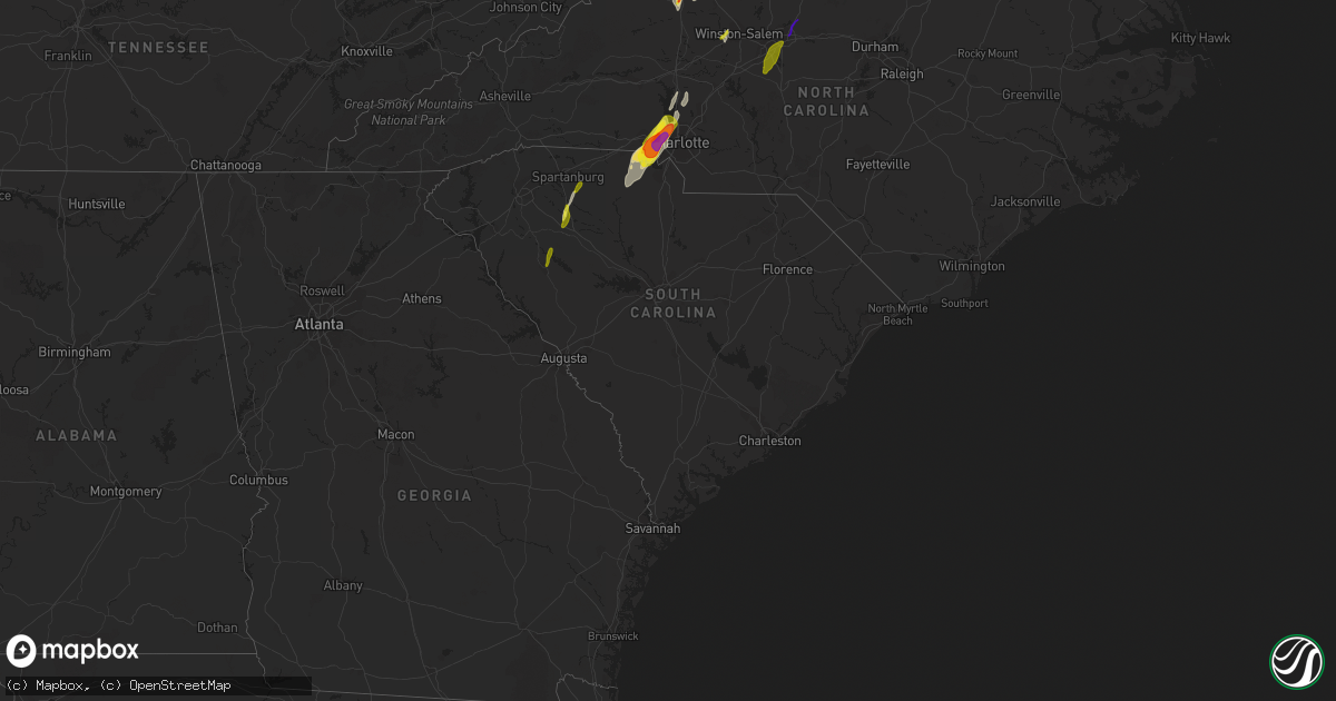
Hail Map in South Carolina on April 15, 2018
Get this storm
April 15 map
$229
one time, instant access
Download today. No call, no setup
Keep the $229
Bought the map and want the full workflow? Apply the entire $229 to a subscription within 7 days. None of it is wasted.
Every map, not just this one
This buys you this map. Subscription and you get every map we run, in the markets you choose from a few cities to whole states to nationwide. Plus real-time alerts the moment a storm fires.
Contact data
Name, contact info, occupancy, even credit band for addresses in the footprint. You go from where it hit to who to call.
Become the source they trust
Unlimited branding weather history reports on demand. You already have the documented answer ready for the property owner, and you are the one who showed up with it.
Property data and RoofTrace estimates
Pull up any address you have got, its value and the exact code rules for that jurisdiction, straight from One Click Code. Then RoofTrace estimates the squares, pitch, and roof value, priced the way you price.
Storm reports in South Carolina
South Carolina
| Date | Description |
|---|---|
| 04/15/20186:57 PM CDT | Tree down on browns ferry rd 1 mile west of browns ferry bridge |
| 04/15/20186:25 PM CDT | Tree down on us 521 between sc 377 and salters overpass |
| 04/15/20185:37 PM CDT | South carolina highway patrol reported a tree down on overrun street near bishop drive. |
| 04/15/20185:34 PM CDT | A large tree limb fell onto a home on clay lane in the carolina bay subdivision and damaged the roof on the front side of the house. |
| 04/15/20185:32 PM CDT | The street facing wall of a large warehouse was blown down. The building is located on the 600 block of bear swamp road. The event time was determined using radar data. |
| 04/15/20185:32 PM CDT | South carolina highway patrol reported a tree down in the 1600 block of cypress campground road. |
| 04/15/20185:28 PM CDT | Dorchester county dispatch reported a tree down on orangeburg road near pinewood preparatory school. |
| 04/15/20185:23 PM CDT | South carolina highway patrol reported a tree down on campbell thickett road near highway 78. |
| 04/15/20185:16 PM CDT | South carolina highway patrol reported a tree down on ridge road near haven road. |
| 04/15/20184:25 PM CDT | South carolina highway patrol reported a tree down on bridge point near west haven. |
| 04/15/20184:00 PM CDT | Tree down blocking road on hwy 917 near cattle farm rd |
| 04/15/20183:56 PM CDT | Tree down in roadway at sc 381 just west of driggers chapel rd |
| 04/15/20183:50 PM CDT | Tree down in roadway at screw pin rd and salem rd |
| 04/15/20183:48 PM CDT | Tree down in roadway at screw pin rd and nolan rd |
| 04/15/20183:30 PM CDT | Tree down in roadway at dunbar highway near allen ridge rd |
| 04/15/20183:28 PM CDT | Chesterfield county sheriff reported trees down in downtown chesterfield. |
| 04/15/20183:00 PM CDT | Corrects previous tstm wnd dmg report from 1 ne millwood. Public report with picture of awning over gas pumps heavily damaged at service station on alice drive. Time es |
| 04/15/20182:56 PM CDT | Chesterfield county sheriff reported trees down in pageland. |
| 04/15/20182:52 PM CDT | County dispatch and schp reports trees and powerlines down at multiple locations including wedgefield road and oakland ave... Alice drive and wesmark... Catchall road.. |
| 04/15/20182:40 PM CDT | County dispatch/em reported numerous trees down and power outages in kershaw county from camden up to hwy 346/timrod road. Time estimated by radar. |
| 04/15/20182:16 PM CDT | Lancaster sheriff reported trees and power lines down across the area. |
| 04/15/20182:13 PM CDT | Em reported several trees and powerlines down on cimmeron road. |
| 04/15/20182:13 PM CDT | Power lines down on sc-9 at potter road. Time estimated by radar. |
| 04/15/20182:11 PM CDT | Widespread straight line wind damage in the lancaster area from flat creek rd northward along baker place rd to south potter rd near pageland highway. Several hardwood |
| 04/15/20182:08 PM CDT | Em reported house with roof damage on doc holliday circle. |
| 04/15/20182:08 PM CDT | Several houses damaged on doc holliday circle. Trees twisted to the north across highway 9 to potter road. Public reported funnel cloud. |
| 04/15/20182:04 PM CDT | Numerous trees down... Multiple houses with tree and wind damage. Time estimated from radar. |
| 04/15/20182:04 PM CDT | Large limbs and branches down at mt gallant rd and india hook rd. Time estimated from radar. |
| 04/15/20182:00 PM CDT | Mostly marble sized hail with some as large as golf ball sized. Hail lasted about 2 minutes. |
| 04/15/20182:00 PM CDT | Public report with picture of awning over gas pumps heavily damaged at service station on alice drive. Time estimated by radar. |
| 04/15/20181:54 PM CDT | Numerous trees reported down from ridgeway to mitford. |
| 04/15/20181:50 PM CDT | Em reported numerous structures damaged. Trees down. Gunsite road and woodside near lake wateree. |
| 04/15/20181:46 PM CDT | Nws storm survey confirms an ef1 tornado in fairfield county. Straight line wind damage began in and near the town of ridgeway. Extensive tree damage... With many trees |
| 04/15/20181:45 PM CDT | *** 1 inj *** tree blown down onto a vehicle at intersection of allison creek road and highway 274. One injury. |
| 04/15/20181:45 PM CDT | Several trees down with a few falling on powerlines. |
| 04/15/20181:44 PM CDT | Tree in roadway columbia road at sims street. Time estimated by radar. |
| 04/15/20181:40 PM CDT | Oak tree on house. Trees twisted downtown ridgeway. |
| 04/15/20181:36 PM CDT | Power lines down reported on clamp road near 25-mile creek. Time estimated by radar. |
| 04/15/20181:36 PM CDT | Trained spotter reported multiple trees down along hwy 321 near fairfield/richland county line. Hwy 321 is passable. Time estimated by radar. |
| 04/15/20181:33 PM CDT | Sc highway patrol reported trees down on i-26. |
| 04/15/20181:26 PM CDT | Power lines down reported on fairfield road and on lincolnshire blvd. Time estimated by radar. |
| 04/15/20181:26 PM CDT | Sc highway patrol reported trees down on broad river road and mik...e stuck road. |
| 04/15/20181:25 PM CDT | Richland county mesonet site measured a 60 mph wind gust near broad river road and st. Andrews road. |
| 04/15/20181:24 PM CDT | Strong straight-line winds caused numerous downed trees along kennerly road from lum road to miles bowman road. The most significant damage was located along the 2200 b |
| 04/15/20181:21 PM CDT | A trained spotter reported a tree down on highway 301/321 blocking the northbound side just before the bamberg county line. |
| 04/15/20181:21 PM CDT | Sc highway patrol reported power lines down on koon street and monticello street. |
| 04/15/20181:20 PM CDT | Trees snapped in half. |
| 04/15/20181:20 PM CDT | The damage from the downburst was mainly confined to a cove along lake murray off of muskrat run. The maximum wind speeds associated with the event ranged from 90-100 m |
| 04/15/20181:19 PM CDT | Trees reported down 5119 sunset blvd and also at platt springs road. |
| 04/15/20181:18 PM CDT | Trees in roadway 2400 ashland road and marydale lane. |
| 04/15/20181:18 PM CDT | Trained spotter reported 72 mph wind gust on home weather station. Small to medium tree limbs and debris down. |
| 04/15/20181:18 PM CDT | Tree reported on house in the riverwalk community. Pictures of damage received via social media. Time estimated by radar. |
| 04/15/20181:17 PM CDT | Corrects previous tornado report from 2 w seven oaks. Nws storm survey confirmed an ef1 tornado. The tornado damage began just north of the saluda river near saluda sho |
| 04/15/20181:17 PM CDT | 74 mph wind gust recorded at columbia metro airport asos. |
| 04/15/20181:15 PM CDT | Trees and powerlines down reported on mineral srings rd at oak drive. |
| 04/15/20181:15 PM CDT | Corrects previous tornado report from 2 nne lexington. Nws storm survey confirmed an ef0 tornado. The tornado damage began near saddlebrooke road. The tornado continued |
| 04/15/20181:14 PM CDT | The damage occurred between maritime trail and lake murray terrace off of yachting road. The maximum winds speeds associated with the event ranged from 100-110 mph. The |
| 04/15/20181:13 PM CDT | Sc highway patrol reported trees down on us 278 and dakota drive. |
| 04/15/20181:09 PM CDT | Trained spotter reports large tree on house with damage to bedrooms. Tree not all the way through roof. Time estimated by radar. |
| 04/15/20181:06 PM CDT | Roof blown off large agricultural building near gilbert on semm sease rd between wire road and hayes crossing road. Debris lofted into tree. Pictures via twitter. Lexin |
| 04/15/20181:05 PM CDT | Tree in roadway mccartha road at platt springs drive. Time estimated by radar. |
| 04/15/20181:03 PM CDT | Tree down on house at 400 laurel drive in lexington. |
| 04/15/20181:03 PM CDT | Nws storm survey confirms a tornado in gilbert... South carolina. The tornado began near two notch road near hayes crossing road. The tornado continued on a north to no |
| 04/15/20181:00 PM CDT | A downburst occurred along a line producing severe thunderstorms winds. The winds were estimated to range from 80 to 105 mph. The strong winds damaged two single wide m |
| 04/15/201812:55 PM CDT | Spotter relayed report of multiple trees down and power outage on kirkland road in new holland. Resident estimated 50 mph winds or higher before taking cover. |
| 04/15/201812:43 PM CDT | Trees in roadway reported on highway 278 at orchard road. Time estmd by radar. |
| 04/15/201812:38 PM CDT | Trees in roadway fellowship road at moonlight road. Time estmd by radar. |
| 04/15/201812:29 PM CDT | Tree in roadway gregg hwy and university lane. Time estmd by radar. |
| 04/15/201812:20 PM CDT | 2 trees down in this general area. |
| 04/15/201812:14 PM CDT | Sc highway patrol reported trees down at crest road near downtown edgefield. |
| 04/15/201812:03 PM CDT | Sc highway patrol reported trees down at walker road and white road. |
| 04/15/201812:01 PM CDT | Sc highway patrol reported trees down at country club hills and gregory lake road. |
| 04/15/201812:00 PM CDT | Public reported large tree limbs down |
| 04/15/201811:44 AM CDT | Hail up to the size of a quarter. |
| 04/15/201811:30 AM CDT | Trees down on cokesbury rd. |
| 04/15/201811:30 AM CDT | Numerous trees down in roebuck. Time estimated from radar. |
| 04/15/201811:30 AM CDT | Tree fell and damaged a roof at university commons apartments on grace st. Time estimated from radar. |
| 04/15/201811:30 AM CDT | Numerous trees down in the pauline area. Time estimated from radar. |
| 04/15/201811:30 AM CDT | Tree down on house on highland dr. Time estimated from radar. |
| 04/15/201810:55 AM CDT | Trees down on harris bridge rd. Time estimated from radar. |
| 04/15/20187:47 AM CDT | At 1246 PM EDT, severe thunderstorms were located along a line extending from 10 miles northeast of Forest City to 6 miles southwest of Shelby, moving northeast at 55 mph. HAZARD...60 mph wind gusts and quarter size hail. SOURCE...Radar indicated. IMPACT...Minor hail damage to vehicles is expected. Expect wind damage to trees and power lines. Locations impacted include... Shelby, Morganton, Valdese, Boiling Springs NC, Drexel, Belwood, Lawndale, Fallston, Polkville and Ellenboro. |
| 04/15/20187:41 AM CDT | At 1240 PM EDT, severe thunderstorms were located along a line extending from near Evans to near Fort Gordon to near Hephzibah, moving northeast at 50 mph. HAZARD...60 mph wind gusts. SOURCE...Radar indicated. IMPACT...Expect damage to roofs, siding, and trees. Locations impacted include... Aiken, North Augusta, Grovetown, Evans, Augusta, Martinez, Clearwater, Fort Gordon, Belvedere, Edgefield, Johnston, New Ellenton, Gloverville, Burnettown, Trenton and Murphys Estates.This includes the following highways... Interstate 20 in Georgia between mile markers 189 and 201. Interstate 20 in South Carolina between mile markers 0 and 27. Interstate 520 in Georgia between mile markers 1 and 15. Interstate 520 in South Carolina between mile markers 16 and 23. |
| 04/15/20187:38 AM CDT | At 1238 PM EDT, a severe thunderstorm was located near Laurens, moving northeast at 55 mph. HAZARD...60 mph wind gusts and quarter size hail. SOURCE...Radar indicated. IMPACT...Minor hail damage to vehicles is expected. Expect wind damage to trees and power lines. Locations impacted include... Laurens, Clinton, Pacolet, Buffalo, Jonesville, Waterloo, Croft State Park, Mountville, Pauline and Enoree. |
| 04/15/20187:13 AM CDT | At 1212 PM EDT, a severe thunderstorm was located near Greenwood, moving northeast at 55 mph. HAZARD...60 mph wind gusts and half dollar size hail. SOURCE...Radar indicated. IMPACT...Minor hail damage to vehicles is expected. Expect wind damage to trees and power lines. Locations impacted include... Greenwood, Cross Hill, Cokesbury, Waterloo, Lake Greenwood, Promised Land, Bradley, Coronaca, Mountville and Callison. |
| 04/15/20186:50 AM CDT | At 1150 AM EDT, a severe thunderstorm was located 8 miles northwest of Laurens, or over Gray Court, moving northeast at 55 mph. HAZARD...60 mph wind gusts and quarter size hail. SOURCE...Radar indicated. IMPACT...Minor hail damage to vehicles is expected. Expect wind damage to trees and power lines. Locations impacted include... Spartanburg, Laurens, Simpsonville, Five Forks, Fountain Inn, Woodruff, Duncan, Lyman, Wellford and Inman. |
| 04/15/20183:31 AM CDT | At 830 PM EDT, severe thunderstorms were located along a line extending from near Sanford to near Prospect, moving northeast at 80 mph. HAZARD...60 mph wind gusts. SOURCE...Radar indicated. IMPACT...Expect damage to roofs, siding, and trees. Locations impacted include... Fayetteville, Cary, Sanford, Laurinburg, Raeford, Fort Bragg, Fuquay-Varina, Maxton, Pope AFB and Antioch. |
| 04/15/20182:52 AM CDT | At 751 PM EDT, severe thunderstorms were located along a line extending from Lake City to near Warsaw, moving north at 55 mph. HAZARD...60 mph wind gusts and penny size hail. SOURCE...Radar indicated. IMPACT...Expect damage trees and power lines. Locations impacted include... Marion, Dillon, Lake City, Mullins, Horry, Johnsonville, Latta, Pamplico, Lake View, Hemingway, Sellers, Rhems, Blue Brick, Hamer, Nesmith, Rains, Morrisville, Minturn, Galivants Ferry and Warsaw.This includes the following highways... Interstate 95 IN South Carolina between mile markers 177 and 198. SC Highway 22 between mile markers 1 and 6. |
| 04/14/201811:55 PM CDT | At 453 PM EDT, a line of severe thunderstorms were approaching from the south. These storms were located near Mccoll, or near Bennettsville, moving north at 45 mph. HAZARD...60 mph wind gusts and quarter size hail. SOURCE...Radar indicated. IMPACT...Hail damage to vehicles is expected. Expect wind damage to roofs, siding, and trees. Locations impacted include... Laurinburg, Southern Pines, Raeford, Carthage, Pinehurst, Aberdeen, Maxton, Antioch, Whispering Pines and Pinebluff. |
| 04/14/201811:47 PM CDT | At 446 PM EDT, a severe thunderstorm was located over Evergreen, or 9 miles southeast of Florence, moving northeast at 55 mph. HAZARD...60 mph wind gusts. SOURCE...Radar indicated. IMPACT...Expect damage trees and power lines. Locations impacted include... Florence, Bennettsville, Marion, Dillon, Mccoll, Latta, Pamplico, Quinby, Lake View, Clio, Sellers, Fork, Blue Brick, Zion, Hamer, Mars Bluff, Brownsville, South Of The Border, New Hope and Minturn.This includes Interstate 95 IN South Carolina between mile markers165 and 198. |
| 04/14/201811:38 PM CDT | At 437 PM EDT, a line of severe thunderstorms were moving or training northward through Anson and eastern Stanly Counties. These storm line will move east into Richmond and Montgomery Counties, while individual storms will move northward along the line. HAZARD...60 mph wind gusts and quarter size hail. SOURCE...Radar indicated. IMPACT...Hail damage to vehicles is expected. Expect wind damage to roofs, siding, and trees. Locations impacted include... Albemarle, Rockingham, Wadesboro, Troy, Badin Lake, Hamlet, Biscoe, Ansonville, Hoffman and Polkton. |
| 04/14/201811:10 PM CDT | At 409 PM EDT, a severe thunderstorm was located near Gourdin, or 10 miles southwest of Kingstree, moving northeast at 55 mph. HAZARD...60 mph wind gusts. SOURCE...Radar indicated. IMPACT...Expect damage trees and power lines. Locations impacted include... Lake City, Kingstree, Johnsonville, Pamplico, Trio, Salters, Hyman, Hannah, Cades, Poston, Gourdin, Indiantown, Gresham, Hebron, Friendfield, Kingsburg, Scranton, Coward, Olanta and Lane. |
| 04/14/201810:48 PM CDT | At 345 PM EDT, severe thunderstorms extended from Lancaster County southward into Kershaw County. Storm movement was northeast near 50 mph and toward Chesterfield County. HAZARD...60 mph wind gusts. SOURCE...Radar indicated. IMPACT...Expect damage to roofs, siding, and trees. Locations impacted include... Cheraw, Pageland, Chesterfield, Mcbee, Jefferson, Ruby, Patrick and Mount Croghan. |
| 04/14/201810:45 PM CDT | At 344 PM EDT, a severe thunderstorm was located near Midland, or 14 miles north of Monroe, moving northeast at 50 mph. HAZARD...70 mph wind gusts and quarter size hail. SOURCE...Radar indicated. IMPACT...Hail damage to vehicles is expected. Expect considerable tree damage. Wind damage is also likely to mobile homes, roofs, and outbuildings. Locations impacted include... Albemarle, Badin Lake, Ansonville, Plyler, Midland, Polkton, Locust, Norwood, Badin and Oakboro. |
| 04/14/201810:32 PM CDT | At 330 PM EDT, weather radar showed numerous thunderstorms extending from the area northeast of Orangeburg to near Bishopville. Movement was northeast near 40 mph. Some of these storms likely contained wind gusts of 40 to 60 mph. HAZARD...60 mph wind gusts. SOURCE...Radar indicated. IMPACT...Expect damage to roofs, siding, and trees. Locations impacted include... Sumter, Manning, Bishopville, South Sumter, Summerton, Eastover, Elloree, Oakland, Mulberry, Millwood, Santee, Turbeville, Mayesville, Pinewood, Cameron, Lynchburg, Paxville, Cane Savannah, Dalzell and Wedgewood.This includes the following highways... Interstate 20 in South Carolina between mile markers 104 and 125. Interstate 95 between mile markers 98 and 146. |
| 04/14/201810:25 PM CDT | At 324 PM EDT, a severe thunderstorm was located 4 miles southwest of Huntersville, moving northeast at 50 mph. HAZARD...60 mph wind gusts and quarter size hail. SOURCE...Radar indicated. IMPACT...Minor hail damage to vehicles is expected. Expect wind damage to trees and power lines. Locations impacted include... Gastonia, Uptown Charlotte, Huntersville, Kannapolis, Salisbury, Statesville, Central Charlotte, Northeast Charlotte, Southwest Charlotte and Northwest Charlotte. |
| 04/14/201810:15 PM CDT | At 315 PM EDT, a severe thunderstorm was located 9 miles north of Lancaster, or 4 miles south of Waxhaw, moving north at 65 mph. HAZARD...60 mph wind gusts and quarter size hail. SOURCE...Radar indicated. IMPACT...Minor hail damage to vehicles is expected. Expect wind damage to trees and power lines. Locations impacted include... Uptown Charlotte, Monroe, South Charlotte, East Charlotte, Matthews, Mint Hill, Indian Trail, Weddington, Stallings and Unionville. |
| 04/14/201810:01 PM CDT | At 259 PM EDT, severe thunderstorms were along the Kershaw and Fairfield County line and along the Lancaster and Fairfield County line. Movement was northeast at 50 mph. HAZARD...70 mph wind gusts. SOURCE...Radar indicated. IMPACT...Expect considerable tree damage. Damage is likely to mobile homes, roofs, and outbuildings. Locations impacted include... Lancaster, Kershaw, Elgin, Heath Springs, Bethune and Lancaster Mill.This includes Interstate 20 in South Carolina between mile markers100 and 105. |
| 04/14/20189:44 PM CDT | At 243 PM EDT, a severe thunderstorm was located 10 miles northwest of Chester, or 4 miles northwest of Lowrys, moving north at 65 mph. HAZARD...60 mph wind gusts and quarter size hail. SOURCE...Radar indicated. IMPACT...Minor hail damage to vehicles is expected. Expect wind damage to trees and power lines. Locations impacted include... Rock Hill, Uptown Charlotte, Chester, Central Charlotte, Southwest Charlotte, Northwest Charlotte, Mt Holly, Fort Mill, Belmont and Pineville. |
| 04/14/20189:40 PM CDT | At 239 PM EDT, severe thunderstorms extended from central Fairfield County southward into central Richland County. Movement was northeast near 50 mph. HAZARD...70 mph wind gusts. SOURCE...Radar indicated. IMPACT...Expect considerable tree damage. Damage is likely to mobile homes, roofs, and outbuildings. Locations impacted include... Lancaster, Camden, Lugoff, Irwin and Lancaster Mill. This includes the following highways... Interstate 20 in South Carolina between mile markers 82 and 99. Interstate 77 between mile markers 41 and 51. |
| 04/14/20189:18 PM CDT | At 217 PM EDT, severe thunderstorms extended along the Fairfield and Newberry County line southeastward and into the Columbia area. Movement was northeast near 50 mph. HAZARD...70 mph wind gusts. SOURCE...Radar indicated. IMPACT...Expect considerable tree damage. Damage is likely to mobile homes, roofs, and outbuildings. Locations impacted include... Columbia, Lexington, West Columbia, Cayce, Irmo, Forest Acres, Winnsboro, Springdale, St. Andrews, Dentsville, Oak Grove, Woodfields, South Congaree, Pine Ridge, Gaston, Arcadia Lakes, Woodfield, Fort Jackson, Five Points and Blythewood.This includes the following highways... Interstate 126 between mile markers 0 and 3. Interstate 20 in South Carolina between mile markers 57 and 81. Interstate 26 between mile markers 92 and 127. Interstate 77 between mile markers 0 and 39. |
| 04/14/20189:13 PM CDT | At 212 PM EDT, likely severe thunderstorms were in the Savannah River Site moving northeast near 50 mph. HAZARD...60 mph wind gusts. SOURCE...Radar indicated. IMPACT...Expect damage to roofs, siding, and trees. Locations impacted include... Orangeburg, Barnwell, Bamberg, Denmark, Savannah River Site, Brookdale, Williston, Blackville, Branchville, Swansea, North, Ehrhardt, Springfield, Hilda, Salley, Neeses, Norway, Rowesville, Snelling and Olar.This includes Interstate 26 between mile markers 123 and 127. |
| 04/14/20188:42 PM CDT | At 141 PM EDT, severe thunderstorms were located along a line extending from 6 miles northwest of Ridge Spring to 14 miles east of Aiken to near Williston, moving northeast at 55 mph. HAZARD...70 mph wind gusts. SOURCE...Law enforcement reported damaging wind gusts and downed trees with this line of storms. IMPACT...Expect considerable tree damage. Damage is likely to mobile homes, roofs, and outbuildings. Locations impacted include... Lexington, West Columbia, Cayce, Irmo, Newberry, Red Bank, St. Andrews, Batesburg-Leesville, Saluda, South Congaree, Pine Ridge, Gaston, Prosperity, Ridge Spring, Chapin and Swansea.This includes the following highways... Interstate 126 between mile markers 0 and 1. Interstate 20 in South Carolina between mile markers 22 and 64. Interstate 26 between mile markers 69 and 92, and between milemarkers 104 and 120. Interstate 77 between mile markers 0 and 1. |
| 04/14/20188:18 PM CDT | At 117 PM EDT, a severe thunderstorm was located over Statesboro, moving northeast at 50 mph. HAZARD...60 mph wind gusts. SOURCE...Radar indicated. IMPACT...Expect damage to trees and powerlines. Locations impacted include... Statesboro, Sylvania, Middleground, Brooklet, Portal, Newington, Oliver and Rocky Ford. |
| 04/14/20187:30 PM CDT | Tree down near sunny mart on sc 9 |
| 04/14/20187:03 PM CDT | Tree down on the florence side of willow grove rd |
| 04/14/20187:03 PM CDT | Tree down on sc highway 41 |
All States Impacted by Hail Map on April 15, 2018
Cities Impacted by Hail Map on April 15, 2018
- Max Meadows, VA
- Hillsville, VA
- Fancy Gap, VA
- Dugspur, VA
- Laurel Fork, VA
- Willis, VA
- Enoree, SC
- Mooresville, NC
- Cornelius, NC
- Galax, VA
- Ararat, VA
- Fort Pierce, FL
- McAdenville, NC
- Gastonia, NC
- Mount Holly, NC
- Belmont, NC
- Clover, SC
- Lowell, NC
- Stanley, NC
- Cramerton, NC
- York, SC
- Charlotte, NC
- Dobson, NC
- Lowgap, NC
- Cana, VA
- Elkin, NC
- State Road, NC
- Woodlawn, VA
- Lambsburg, VA
- Hiwassee, VA
- Thurmond, NC
- Mount Airy, NC
- Woodbine, GA
- Huntersville, NC
- Smyrna, SC
- Sharon, SC
- Austinville, VA
- Vero Beach, FL
- Fries, VA
- Clemmons, NC
- Winston Salem, NC
- Lewisville, NC
- Davidson, NC
- Mount Ulla, NC
- Kingsland, GA
- Woodruff, SC
- Pauline, SC
- Laurens, SC
- Spartanburg, SC
- Pacolet, SC
- Waterloo, SC
- Greenwood, SC
- Hodges, SC
- Woolwine, VA
- Meadows Of Dan, VA
- Floyd, VA
- Riner, VA
- Pilot, VA
- High Point, NC
- Trinity, NC
- Jamestown, NC
- Greensboro, NC
- Randleman, NC
- Sophia, NC
- Browns Summit, NC
- Tallahassee, FL
- Crawfordville, FL
- Greenville, FL
- O'Brien, FL


