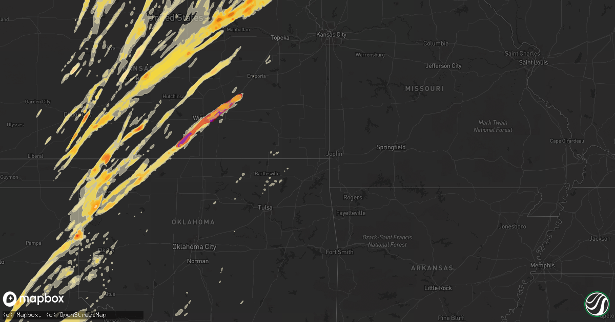
Hail Map in Kansas on April 14, 2012
Get this storm
April 14 map
$229
one time, instant access
Download today. No call, no setup
Keep the $229
Bought the map and want the full workflow? Apply the entire $229 to a subscription within 7 days. None of it is wasted.
Every map, not just this one
This buys you this map. Subscription and you get every map we run, in the markets you choose from a few cities to whole states to nationwide. Plus real-time alerts the moment a storm fires.
Contact data
Name, contact info, occupancy, even credit band for addresses in the footprint. You go from where it hit to who to call.
Become the source they trust
Unlimited branding weather history reports on demand. You already have the documented answer ready for the property owner, and you are the one who showed up with it.
Property data and RoofTrace estimates
Pull up any address you have got, its value and the exact code rules for that jurisdiction, straight from One Click Code. Then RoofTrace estimates the squares, pitch, and roof value, priced the way you price.
Storm reports in Kansas
Kansas
| Date | Description |
|---|---|
| 04/14/20126:55 PM CDT | Tornado on the ground at new cambria |
| 04/14/20126:55 PM CDT | Tornado touched down briefly west of varner. |
| 04/14/20126:44 PM CDT | A local report indicates 1.00 inch wind near 6 NE KINGMAN |
| 04/14/20126:38 PM CDT | Structure damage to farmhouse. |
| 04/14/20126:35 PM CDT | Hail lasted between 5 to 10 minutes long. |
| 04/14/20126:25 PM CDT | A tornado 1.5 miles northwest of falun and muir road. Large visible debri detected. |
| 04/14/20126:19 PM CDT | A local report indicates a tornado near 6 W ASSARIA |
| 04/14/20126:09 PM CDT | A large tornado about one quarter mile wide was near k4 and highway 141. Tornado was now entering into saline county. |
| 04/14/20126:09 PM CDT | A tornado on the ground just southwest of the town of falun. Also seeing debri. |
| 04/14/20126:01 PM CDT | Large wedge tornado on ground. |
| 04/14/20125:45 PM CDT | Wedge tornado still on ground. |
| 04/14/20125:37 PM CDT | Large wedge tornado. |
| 04/14/20125:35 PM CDT | Tornado on ground |
| 04/14/20125:03 PM CDT | Quarter size hail west of chase on highway 56. |
| 04/14/20125:02 PM CDT | Brief tornado touchdown |
| 04/14/20125:00 PM CDT | A local report indicates 1.75 inch wind near E ELLINWOOD |
| 04/14/20124:54 PM CDT | A local report indicates 1.25 inch wind near 3 E ELLINWOOD |
| 04/14/20124:51 PM CDT | Quarter to pea size hail. |
| 04/14/20124:50 PM CDT | A local report indicates a tornado near NW SAWYER |
| 04/14/20124:50 PM CDT | A local report indicates a tornado near 6 SSE ELLINWOOD |
| 04/14/20124:48 PM CDT | A local report indicates a tornado near 1 W SAWYER |
| 04/14/20124:40 PM CDT | A local report indicates 1.25 inch wind near WNW SAWYER |
| 04/14/20124:35 PM CDT | A local report indicates 2.50 inch wind near SAWYER |
| 04/14/20124:25 PM CDT | A local report indicates a tornado near 1 SE SEWARD |
| 04/14/20124:25 PM CDT | The hail smashed though the skylight of the spotters home. |
| 04/14/20124:25 PM CDT | A local report indicates a tornado near 5 W HUDSON |
| 04/14/20124:05 PM CDT | A local report indicates a tornado near 2 E TIMKEN |
| 04/14/20123:46 PM CDT | Brief tornado touchdown just south of the town of rush center. |
| 04/14/20123:43 PM CDT | A local report indicates 60 MPH wind near 3 N CUBA |
| 04/14/20123:43 PM CDT | A local report indicates a tornado near 5 W ASH VALLEY |
| 04/14/20123:35 PM CDT | A local report indicates 1.50 inch wind near SUMMERFIELD |
| 04/14/20123:34 PM CDT | A local report indicates a tornado near 10 N ROZEL |
| 04/14/20123:30 PM CDT | A local report indicates 1.00 inch wind near 7 N BEATTIE |
| 04/14/20123:30 PM CDT | Tornado tore up storage bins on his neighbors farm. |
| 04/14/20123:25 PM CDT | A local report indicates a tornado near 5 W ASH VALLEY |
| 04/14/20123:25 PM CDT | A tornado was observed. The tornado destroyed numerous farm implements including flipping 4 grain augers through a grain bin. Two complete pivot irrigation systems were |
| 04/14/20123:23 PM CDT | A local report indicates 1.00 inch wind near 1 ENE MARYSVILLE |
| 04/14/20123:21 PM CDT | A local report indicates 1.00 inch wind near 6 WSW BEATTIE |
| 04/14/20123:20 PM CDT | A local report indicates 2.00 inch wind near ENE MULLINVILLE |
| 04/14/20123:05 PM CDT | A local report indicates 1.00 inch wind near SSE BARNES |
| 04/14/20122:58 PM CDT | Sheriff reported tornado 2 to 3 miles west of burdette. |
| 04/14/20122:56 PM CDT | A local report indicates a tornado near 1 E BURDETT |
| 04/14/20122:55 PM CDT | A local report indicates a tornado near 1 SE BURDETT |
| 04/14/20122:54 PM CDT | A local report indicates a tornado near 2 W ROZEL |
| 04/14/20122:50 PM CDT | A local report indicates a tornado near 2 E GRAY |
| 04/14/20122:46 PM CDT | A local report indicates 1.00 inch wind near 3 WNW CLYDE |
| 04/14/20122:45 PM CDT | A local report indicates 60 MPH wind near BELOIT |
| 04/14/20122:30 PM CDT | Power lines reported down in the glen elder reservior area. |
| 04/14/20122:30 PM CDT | A local report indicates 1.75 inch wind near BUCKLIN |
| 04/14/20122:28 PM CDT | A wall cloud with a funnel appearing to reach to near the ground was observed from a distance of about 6 miles from the observation point northeast of the possible torn |
| 04/14/20122:23 PM CDT | The tornado was observed from a residence 3 miles southeast. |
| 04/14/20122:20 PM CDT | Power poles down and power lines down across highway 18 between lucas and luray. |
| 04/14/20122:14 PM CDT | Storm chaser reported a wrapped tornado 1.5 miles south of tipton. Emergency management had a report of some tin taken from a building in the same general area. A garag |
| 04/14/20122:09 PM CDT | Public reported a tornado crossing highway 283 on the hodgeman and ford county line. |
| 04/14/20121:54 PM CDT | Some outbuildings damaged or destroyed along with power pole lines down. |
| 04/14/20121:45 PM CDT | A local report indicates 2.00 inch wind near 9 NW ENGLEWOOD |
| 04/14/20121:45 PM CDT | A local report indicates 65 MPH wind near 4 N LUCAS |
| 04/14/20121:40 PM CDT | A local report indicates 1.00 inch wind near HOWELL |
| 04/14/20121:40 PM CDT | Public reported a tornado crossing highway 283 on the hodgeman and ford county line. |
| 04/14/20121:33 PM CDT | Electric lines down and power pole lines snapped. |
| 04/14/20121:33 PM CDT | Out building damaged with debri scattered 3/4 of mile northeast of impact. |
| 04/14/20121:33 PM CDT | Damage to an old school house was reported at this location. Damage to outbuildings were also reported along 232 rd. |
| 04/14/20121:32 PM CDT | A local report indicates 1.00 inch wind near 9 NW ENGLEWOOD |
| 04/14/20121:22 PM CDT | A local report indicates 74 MPH wind near RUSSELL AIRPORT |
| 04/14/20121:20 PM CDT | On highway 70 at mile marker 188 a few roads signs are blown over or snapped. Trash blown around at rest area east of russell. |
| 04/14/201212:30 PM CDT | This is post event verification from severe weather that occurred yesterday. |
| 04/14/201212:30 PM CDT | The observer noted a couple of brief touchdowns over a few minutes. |
| 04/14/201212:17 PM CDT | Tree limbs were blown across the road. A power pole was snapped off near the base. An entire irrigation pivot system was blown over. This could have been either straigh |
| 04/14/201212:17 PM CDT | Tree limbs were thrown across the road. A power pole was snapped off near the base. An entire irrigation system was blown over. This could have been straight line winds |
| 04/14/201212:16 PM CDT | Tree limbs were blown across the road. A pivot irrigation system was blown over and a power pole was snapped off near the base. This could have been a tornado or straig |
| 04/14/201212:08 PM CDT | A local report indicates 1.75 inch wind near 8 S ARNOLD |
| 04/14/201211:40 AM CDT | A local report indicates 1.00 inch wind near 3 N YOCEMENTO |
| 04/14/20124:58 AM CDT | Along highway 400. |
| 04/14/20123:46 AM CDT | A metal outbuilding had its roof ripped off. A hay barn made out of a pole shed was also destroyed. A narrow corridor of cottonwood trees were also heavily damaged. |
| 04/14/20123:20 AM CDT | 6 inch diameter tree limbs down. Delayed report. |
| 04/14/20122:30 AM CDT | Golf ball sized hail west of town. Nickel sized in olsburg. Time estimated by radar. |
| 04/14/20121:55 AM CDT | Time estimated by radar. Delayed report |
| 04/14/20121:53 AM CDT | A local report indicates 1.25 inch wind near VERMILLION |
| 04/14/20121:50 AM CDT | Minor crop damage also reported. Estimated 3 to 4 inches of rainfall also. |
| 04/14/20121:50 AM CDT | Delayed report |
| 04/14/20121:46 AM CDT | A local report indicates 1.00 inch wind near 5 S FRANKFORT |
| 04/14/20121:45 AM CDT | A local report indicates 2.50 inch wind near BLAINE |
| 04/14/20121:20 AM CDT | A local report indicates 1.75 inch wind near 1 W OLSBURG |
| 04/14/20121:17 AM CDT | A local report indicates 4.50 inch wind near RANDOLPH |
| 04/14/20121:15 AM CDT | A local report indicates 4.25 inch wind near RANDOLPH |
| 04/14/20121:05 AM CDT | Grapefruit size hail put holes in roofs of cars and broke all west facing house windows. Time estimated. |
| 04/14/201212:58 AM CDT | A local report indicates 2.00 inch wind near WAKEFIELD |
| 04/14/201212:06 AM CDT | Storm chasers reported a brief tornado in open field. |
| 04/13/201211:39 PM CDT | Large wedge tornado |
| 04/13/201211:38 PM CDT | 60 to 70 mph. |
| 04/13/201211:34 PM CDT | On the ground. |
| 04/13/201211:29 PM CDT | A local report indicates 1.50 inch wind near WSW MOONLIGHT |
| 04/13/201211:26 PM CDT | A local report indicates 1.75 inch wind near 4 S CASSODAY |
| 04/13/201211:25 PM CDT | Tornado illuminated by lightning. |
| 04/13/201211:22 PM CDT | A local report indicates a tornado near 1 ENE NEW CAMBRIA |
| 04/13/201211:22 PM CDT | Off duty ncar meteorologist. |
| 04/13/201211:18 PM CDT | Damage to a house near kanopolis...time estimated |
| 04/13/201211:18 PM CDT | Large wedge tornado roughly 9 miles nne of el dorado |
| 04/13/201211:14 PM CDT | Power flashes northeast of el dorado. |
| 04/13/201211:10 PM CDT | Spotter reported a cone to wedge tornado |
| 04/13/201211:06 PM CDT | Power outages on the west side of el dorado |
| 04/13/201211:06 PM CDT | Near the best western hotel |
| 04/13/201211:01 PM CDT | Rope tornado. |
| 04/13/201211:01 PM CDT | At the law enforcement center in salina. |
| 04/13/201210:59 PM CDT | Power flashes parsons road and i-135. |
| 04/13/201210:59 PM CDT | Just west on highway 254 |
| 04/13/201210:57 PM CDT | A local report indicates 1.00 inch wind near EL DORADO |
| 04/13/201210:57 PM CDT | A local report indicates 1.75 inch wind near SALINA |
| 04/13/201210:55 PM CDT | Illuminated by lightning. |
| 04/13/201210:49 PM CDT | Tornado crossed santa fe road. |
| 04/13/201210:44 PM CDT | Power flashes noted. |
| 04/13/201210:43 PM CDT | Damage reported near oliver and east 47th street as well as hangar damage to the west side of mcdonnell air force base. |
| 04/13/201210:39 PM CDT | Visible near mcconnell air force base. |
| 04/13/201210:37 PM CDT | On the ground. 71st street south and 134 east. |
| 04/13/201210:35 PM CDT | Damage at 63rd and hydralic. |
| 04/13/201210:32 PM CDT | A local report indicates 76 MPH wind near MCCONNELL AIR FORCE BAS |
| 04/13/201210:29 PM CDT | A local report indicates 84 MPH wind near WICHITA MID CONTINENT A |
| 04/13/201210:26 PM CDT | Damage to a mobile home park south of oaklawn near clifton. |
| 04/13/201210:26 PM CDT | Power lines down on cars. Damage to apartments. |
| 04/13/201210:21 PM CDT | Delayed report of power lines down near south brook and broadway |
| 04/13/201210:06 PM CDT | A local report indicates 70 MPH wind near CLEARWATER |
| 04/13/201210:02 PM CDT | A local report indicates a tornado near 3 W LYONS |
| 04/13/20129:55 PM CDT | A local report indicates 1.00 inch wind near LYONS |
| 04/13/20129:55 PM CDT | A local report indicates 58 MPH wind near JABARA AIRPORT |
| 04/13/20129:52 PM CDT | A local report indicates a tornado near 3 SE RAYMOND |
| 04/13/20129:48 PM CDT | 1/4 to 1/2 mile wide tornado. |
| 04/13/20129:47 PM CDT | A local report indicates 1.00 inch wind near RAYMOND |
| 04/13/20129:42 PM CDT | A local report indicates 1.00 inch wind near GREAT BEND |
| 04/13/20129:42 PM CDT | Stove pipe tornado. |
| 04/13/20129:39 PM CDT | Rain wrapped tornado. From mayfield fire. |
| 04/13/20129:38 PM CDT | Multi vortex tornado south of conway springs. |
| 04/13/20129:37 PM CDT | Unconfirmed report of a house destroyed at west 40th street. Emergency vehicles in route. |
| 04/13/20129:35 PM CDT | Storm chaser reported a large wedge tornado to the east of his position. |
| 04/13/20129:31 PM CDT | House destroyed west of conway springs. |
| 04/13/20129:30 PM CDT | A 1/2 mile wide wedge on the ground. |
| 04/13/20129:29 PM CDT | Trained spotters reported very large tornado |
| 04/13/20129:23 PM CDT | Wedge tornado on the ground with power flashes. |
| 04/13/20129:21 PM CDT | Spotter reported seeing power flashes |
| 04/13/20129:21 PM CDT | Sheriffs deputy reported a large tornado just north of st. John. |
| 04/13/20129:18 PM CDT | On the ground near highway 44 and argonia road. |
| 04/13/20129:17 PM CDT | A local report indicates 1.00 inch wind near 6 W PHILLIPSBURG |
| 04/13/20129:14 PM CDT | Stove pipe tornado on the ground. |
| 04/13/20129:13 PM CDT | Damage to a house and a barn destroyed. No injuries. |
| 04/13/20129:10 PM CDT | Wedge tornado. |
| 04/13/20129:00 PM CDT | Spotters were 3 miles south of antelope and viewed the tornado 5 to 8 miles to the north. |
| 04/13/20129:00 PM CDT | On the ground. Illuminated by lightning. |
| 04/13/20129:00 PM CDT | Also 50 mph winds |
| 04/13/20129:00 PM CDT | Brief ef0 tornado touched down. Minor tree damage reported. |
| 04/13/20129:00 PM CDT | Large wedge tornado. Approximately a 1/2 mile wide. |
| 04/13/20128:57 PM CDT | Nickels and quater sized hail reported |
| 04/13/20128:55 PM CDT | A local report indicates 1.00 inch wind near BURR OAK |
| 04/13/20128:52 PM CDT | Power lines down along highway 179 one mile north of the kansas oklahoma state line. |
| 04/13/20128:50 PM CDT | Damage along a tornado path was reported. The damage began at about 180th ave and persisted northeastward to near p and m roads leading to the stafford county line. Dam |
| 04/13/20128:49 PM CDT | A local report indicates 1.00 inch wind near 9 NE HUNTER |
| 04/13/20128:48 PM CDT | A local report indicates 1.00 inch wind near KENSINGTON |
| 04/13/20128:41 PM CDT | A local report indicates 1.00 inch wind near 5 E PHILLIPSBURG |
| 04/13/20128:41 PM CDT | A local report indicates 1.00 inch wind near 5 NE ALMENA |
| 04/13/20128:41 PM CDT | Large tornado on the ground. |
| 04/13/20128:40 PM CDT | A local report indicates 1.50 inch wind near ASH GROVE |
| 04/13/20128:35 PM CDT | Hail was golf ball to tennis ball sized. |
| 04/13/20128:35 PM CDT | A local report indicates a tornado near 2 WNW GREENSBURG |
| 04/13/20128:33 PM CDT | A local report indicates 1.00 inch wind near 7 S PHILLIPSBURG |
| 04/13/20128:33 PM CDT | A local report indicates 1.75 inch wind near ALMENA |
| 04/13/20128:26 PM CDT | A local report indicates 1.50 inch wind near 9 NNE MULLINVILLE |
| 04/13/20128:22 PM CDT | Large wedge tornado reported |
| 04/13/20128:21 PM CDT | A local report indicates 1.75 inch wind near BUNKER HILL |
| 04/13/20128:21 PM CDT | Damage to a garage 1 north and 1/4 mile northwest of 27th and arrowhead. |
| 04/13/20128:18 PM CDT | A local report indicates 1.00 inch wind near EDMOND |
| 04/13/20128:15 PM CDT | A local report indicates 1.50 inch wind near EDMOND |
| 04/13/20128:13 PM CDT | A local report indicates 1.75 inch wind near 6 N SUSANK |
| 04/13/20128:10 PM CDT | Half dollar to ping pong ball size hail. |
| 04/13/20128:08 PM CDT | A local report indicates 1.00 inch wind near 3 N LURAY |
| 04/13/20128:05 PM CDT | A local report indicates 1.75 inch wind near ALBERT |
| 04/13/20128:05 PM CDT | A local report indicates a tornado near 5 NNW HESSTON |
| 04/13/20128:04 PM CDT | Ground white with hail. |
| 04/13/20128:03 PM CDT | Off duty nws employee reported a cone shaped tornado. |
| 04/13/20127:58 PM CDT | Windows were knocked out by hail in kingsdown. |
| 04/13/20127:58 PM CDT | A local report indicates 1.50 inch wind near 8 SSE GRAY |
| 04/13/20127:47 PM CDT | A local report indicates 1.00 inch wind near 7 S SHAFFER |
| 04/13/20127:40 PM CDT | A local report indicates 2.00 inch wind near 6 SE DODGE CITY |
| 04/13/20127:36 PM CDT | Report relayed via wfo pleasant hill |
| 04/13/20127:35 PM CDT | A local report indicates 2.75 inch wind near 8 E DODGE CITY |
| 04/13/20127:31 PM CDT | Via ksn-tv salina |
| 04/13/20127:27 PM CDT | A local report indicates 1.00 inch wind near 9 NW ENGLEWOOD |
| 04/13/20127:19 PM CDT | Golfball-sized hail covered the ground. |
| 04/13/20127:15 PM CDT | Report relayed via wfo pleasant hill |
| 04/13/20127:15 PM CDT | A large metal outbuilding had its roof ripped off by straight line winds. |
| 04/13/20127:10 PM CDT | A local report indicates 1.00 inch wind near 8 SSE FOWLER |
| 04/13/20127:10 PM CDT | Brief tornado touchdown |
| 04/13/20127:08 PM CDT | Large bowl funnel with swirls on the ground reported by chaser. |
| 04/13/20127:07 PM CDT | Ef0 damage at this location. |
| 04/13/20127:05 PM CDT | Report of farm damaged at 280th and aspen roads |
| 04/13/20127:05 PM CDT | Ef1 damage to outbuildings. |
| 04/13/20127:05 PM CDT | Trained spotter reported road signs folded over and some blown 100 yards away and multiple trees down at i-70 and niles road. |
| 04/13/20127:05 PM CDT | Tornado moving east and is to the north of i70 mile marker 263 and approaching the rest area at the saline and dickinson coutny line |
| 04/13/20127:01 PM CDT | A local report indicates a tornado near 4 N NEW CAMBRIA |
All States Impacted by Hail Map on April 14, 2012
Cities Impacted by Hail Map on April 14, 2012
- Burwell, NE
- Bazine, KS
- Oskaloosa, IA
- University Park, IA
- Buffalo, OK
- Yarmouth, IA
- Milan, IL
- Joy, IL
- New London, IA
- Blue Grass, IA
- Davenport, IA
- Wapello, IA
- Andalusia, IL
- Morning Sun, IA
- Illinois City, IL
- Reynolds, IL
- Montpelier, IA
- Salem, IA
- Mount Union, IA
- Muscatine, IA
- Aledo, IL
- Mount Pleasant, IA
- Taylor Ridge, IL
- New Boston, IL
- Mediapolis, IA
- Buffalo, IA
- Mclean, TX
- Lelia Lake, TX
- Wellington, TX
- Hedley, TX
- Higgins, TX
- Shattuck, OK
- Arnett, OK
- Tipton, IA
- West Branch, IA
- Downs, KS
- Luray, KS
- Otis, KS
- Esbon, KS
- Victoria, KS
- Bunker Hill, KS
- Gaylord, KS
- Russell, KS
- Guide Rock, NE
- Superior, NE
- Mankato, KS
- Osborne, KS
- Nelson, NE
- Waldo, KS
- Burr Oak, KS
- Pfeifer, KS
- Lucas, KS
- Paradise, KS
- Gorham, KS
- Ohiowa, NE
- Lakeview, TX
- Quail, TX
- Shamrock, TX
- Memphis, TX
- Clay Center, KS
- Anselmo, NE
- Oakdale, NE
- Tilden, NE
- Newman Grove, NE
- Petersburg, NE
- Albion, NE
- Meadow Grove, NE
- Elgin, NE
- Durham, OK
- Gage, OK
- Protection, KS
- Hardtner, KS
- Mooreland, OK
- Coldwater, KS
- Plainview, TX
- Quitaque, TX
- Silverton, TX
- Medicine Lodge, KS
- Sharon, OK
- Fargo, OK
- Lake City, KS
- Woodward, OK
- Clarendon, TX
- Alva, OK
- Reydon, OK
- Canadian, TX
- Mobeetie, TX
- Wilmore, KS
- Laverne, OK
- Lockney, TX
- Briscoe, TX
- Fort Supply, OK
- May, OK
- Petersburg, TX
- Freedom, OK
- Crawford, OK
- Wheeler, TX
- Central City, NE
- Palmer, NE
- Archer, NE
- Oak, NE
- Seward, NE
- Pleasant Dale, NE
- Garland, NE
- Malcolm, NE
- Raymond, NE
- Ford, KS
- Dodge City, KS
- Spearville, KS
- Wright, KS
- Andover, KS
- Justiceburg, TX
- Idalou, TX
- Lubbock, TX
- Sun City, KS
- Wolfforth, TX
- Greensburg, KS
- Mason City, NE
- Burdett, KS
- Rush Center, KS
- Nekoma, KS
- Bison, KS
- La Crosse, KS
- Rozel, KS
- Hanston, KS
- Elk City, OK
- Brewster, NE
- Arnold, NE
- Taylor, NE
- Sargent, NE
- Dunning, NE
- Sergeant Bluff, IA
- Winnebago, NE
- Homer, NE
- Salix, IA
- Wakeeney, KS
- Ogallah, KS
- Ellis, KS
- Palco, KS
- Bogue, KS
- Damar, KS
- Hastings, IA
- Malvern, IA
- Imogene, IA
- Randolph, IA
- Cherokee, OK
- Stapleton, NE
- Bartlett, NE
- Chambers, NE
- Cedar, IA
- Bussey, IA
- Eddyville, IA
- Fremont, IA
- Ozona, TX
- Midkiff, TX
- Afton, IA
- New Virginia, IA
- Shannon City, IA
- Osceola, IA
- Grand River, IA
- Lorimor, IA
- Ellston, IA
- Creston, IA
- Truro, IA
- Tingley, IA
- Lenox, IA
- Diagonal, IA
- Murray, IA
- Thayer, IA
- Mullinville, KS
- Bucklin, KS
- Magnet, NE
- Osmond, NE
- Creighton, NE
- Randolph, NE
- Crofton, NE
- Bloomfield, NE
- Wausa, NE
- Hartington, NE
- Plainview, NE
- Mclean, NE
- Cunningham, KS
- Pratt, KS
- Nashville, KS
- Follett, TX
- Isabel, KS
- Coats, KS
- Haviland, KS
- Sawyer, KS
- Friend, NE
- Exeter, NE
- Fairmont, NE
- Ollie, IA
- Hedrick, IA
- Fairfield, NE
- Leonardville, KS
- Riley, KS
- Green, KS
- Maxwell, NE
- Gail, TX
- Crosbyton, TX
- Floydada, TX
- Richland, IA
- Silvis, IL
- East Moline, IL
- Sidney, IA
- Tabor, IA
- Percival, IA
- Thurman, IA
- Callaway, NE
- Broken Bow, NE
- Oconto, NE
- Wakefield, KS
- Glenvil, NE
- Juniata, NE
- Salina, KS
- Snyder, TX
- Vermillion, KS
- Frankfort, KS
- Brookville, KS
- Falun, KS
- Lindsborg, KS
- Carter, OK
- Great Bend, KS
- Albert, KS
- Dacoma, OK
- Burns, KS
- Derby, KS
- Wichita, KS
- Clearwater, KS
- Conway Springs, KS
- Milan, KS
- Amorita, OK
- Peck, KS
- Danville, KS
- Freeport, KS
- Benton, KS
- Rose Hill, KS
- Vici, OK
- Potwin, KS
- Burlington, OK
- Anthony, KS
- Bluff City, KS
- Viola, KS
- Caldwell, KS
- Waynoka, OK
- Waldron, KS
- Cassoday, KS
- Matfield Green, KS
- Aline, OK
- Augusta, KS
- Chester, OK
- Harper, KS
- Haysville, KS
- Mcconnell Afb, KS
- Mutual, OK
- Towanda, KS
- Carmen, OK
- Manchester, OK
- Argonia, KS
- El Dorado, KS
- Slaton, TX
- Hiawatha, KS
- White Cloud, KS
- Blackwell, TX
- Concordia, KS
- Beloit, KS
- Olmitz, KS
- Jamestown, KS
- Randall, KS
- Belleville, KS
- Hoisington, KS
- Dorrance, KS
- Jewell, KS
- Norway, KS
- Courtland, KS
- Barnard, KS
- Scandia, KS
- Larned, KS
- Sylvan Grove, KS
- Hunter, KS
- Pawnee Rock, KS
- Seagraves, TX
- Blair, NE
- Lewis, KS
- Kinsley, KS
- Ericson, NE
- Ayr, NE
- Hastings, NE
- Cedar Bluffs, NE
- Colon, NE
- Edison, NE
- McCool Junction, NE
- Cleveland, OK
- Beaver City, NE
- Bertrand, NE
- Hendley, NE
- Arapahoe, NE
- Oxford, NE
- Dixon, IL
- Lenora, KS
- Minneola, KS
- Fowler, KS
- Meade, KS
- Greenleaf, KS
- Corning, KS
- Wallace, NE
- Carroll, NE
- Norfolk, NE
- Hoskins, NE
- Ord, NE
- Winside, NE
- Pilger, NE
- Arcadia, NE
- Loup City, NE
- Stanton, NE
- Lindsay, NE
- Spalding, NE
- Madison, NE
- North Loup, NE
- Wisner, NE
- Belden, NE
- Battle Creek, NE
- Pierce, NE
- Greeley, NE
- Scotia, NE
- Pender, NE
- Paducah, TX
- Washington, IA
- Wayland, IA
- Crawfordsville, IA
- Ainsworth, IA
- Columbus Junction, IA
- Mound City, MO
- Paton, IA
- Dayton, IA
- Pilot Mound, IA
- Boxholm, IA
- Millbrook, IL
- Sheridan, IL
- Plano, IL
- Sandwich, IL
- Somonauk, IL
- Leland, IL
- Yorkville, IL
- Newark, IL
- Oxford, IA
- Watonga, OK
- Bedford, IA
- Big Lake, TX
- Matador, TX
- Marysville, KS
- Swan, IA
- Elk Creek, NE
- Humboldt, NE
- Burchard, NE
- Steinauer, NE
- Table Rock, NE
- Pawnee City, NE
- Johnson, NE
- Home, KS
- Summerfield, KS
- Liberty, NE
- Blue Rapids, KS
- Auburn, NE
- Brock, NE
- Beattie, KS
- Saronville, NE
- Wellfleet, NE
- North Platte, NE
- Pretty Prairie, KS
- Kingman, KS
- Fairbury, NE
- Alexandria, NE
- Olsburg, KS
- Randolph, KS
- Plainville, KS
- Winterset, IA
- Ensign, KS
- Cimarron, KS
- Centralia, KS
- Seneca, KS
- Kennard, NE
- Washington, NE
- Clarinda, IA
- New Market, IA
- Sharpsburg, IA
- Indianola, IA
- Gravity, IA
- Mount Ayr, IA
- Garden City, KS
- Sublette, KS
- Rule, TX
- Haskell, TX
- Crowell, TX
- Kearney, NE
- Gibbon, NE
- Milford, NE
- Alton, KS
- Agra, KS
- Kensington, KS
- Phillipsburg, KS
- Riverton, NE
- Franklin, NE
- Bloomington, NE
- Edgar, NE
- Crab Orchard, NE
- Newton, IA
- Lawton, IA
- Kingsley, IA
- Hinton, IA
- Naponee, NE
- Republican City, NE
- Marlow, OK
- Dickens, TX
- Osceola, NE
- Oakville, IA
- Smith Center, KS
- Packwood, IA
- Lovilia, IA
- Beacon, IA
- Hamilton, IA
- Ottumwa, IA
- Knoxville, IA
- Albia, IA
- Melrose, IA
- Melcher Dallas, IA
- Tracy, IA
- Chariton, IA
- Columbia, IA
- Kirkville, IA
- Lacona, IA
- Hardy, NE
- Republic, KS
- Deshler, NE
- Ackerly, TX
- Abilene, TX
- Lucas, IA
- Woodburn, IA
- Holdrege, NE
- Elwood, NE
- Atlanta, NE
- Loomis, NE
- Smithfield, NE
- Orleans, NE
- Norton, KS
- Wilsonville, NE
- Pleasantville, IA
- Milo, IA
- Butler, OK
- Hammon, OK
- Tahoka, TX
- Odonnell, TX
- Cedar Rapids, IA
- Robert Lee, TX
- Morrowville, KS
- Jansen, NE
- Endicott, NE
- Haddam, KS
- Mahaska, KS
- Diller, NE
- Oswego, IL
- Russell, IA
- Columbus, NE
- Lamesa, TX
- Hays, KS
- Lincoln, NE
- Lenorah, TX
- Knott, TX
- Williamson, IA
- Leighton, IA
- Minneapolis, KS
- Tescott, KS
- Utica, KS
- Beaver, OK
- Moundridge, KS
- Ralls, TX
- Wilcox, NE
- Erie, IL
- Prophetstown, IL
- Hopkins, MO
- Logan, KS
- Campbell, NE
- Goehner, NE
- Dorchester, NE
- Stockton, KS
- Prairie View, KS
- Inavale, NE
- Deweese, NE
- Roseland, NE
- Ashland, NE
- Henderson, NE
- Glade, KS
- Denton, NE
- Davey, NE
- Harvard, NE
- Beaver Crossing, NE
- Waco, NE
- Geneva, NE
- Holstein, NE
- Greenwood, NE
- York, NE
- Clay Center, NE
- Blue Hill, NE
- Grafton, NE
- Gretna, NE
- Ceresco, NE
- Sutton, NE
- Bladen, NE
- Lawrence, NE
- Waverly, NE
- Inland, NE
- Cordova, NE
- Shelton, NE
- Lincolnville, KS
- Tampa, KS
- Marion, KS
- Wood River, NE
- Caney, KS
- Havana, KS
- Independence, KS
- Almena, KS
- Miles, IA
- Preston, IA
- Mertzon, TX
- Lincoln, KS
- Beeler, KS
- Ness City, KS
- Colfax, IA
- Westmoreland, KS
- Elyria, NE
- Merna, NE
- Orchard, NE
- Gothenburg, NE
- Inman, NE
- Tryon, NE
- Maywood, NE
- Amelia, NE
- Page, NE
- Elsie, NE
- Ewing, NE
- Thedford, NE
- Hershey, NE
- Dickens, NE
- Royal, NE
- Comstock, NE
- Brady, NE
- Nodaway, IA
- Gibson, IA
- Grinnell, IA
- Searsboro, IA
- Otley, IA
- Deep River, IA
- Barnes City, IA
- Montezuma, IA
- Reasnor, IA
- Lynnville, IA
- Sully, IA
- New Sharon, IA
- Pella, IA
- Cawker City, KS
- Glen Elder, KS
- Hill City, KS
- Midland, TX
- Willow, OK
- Mangum, OK
- Vinson, OK
- Turon, KS
- Seiling, OK
- Shickley, NE
- Ruskin, NE
- Carleton, NE
- Davenport, NE
- Dighton, KS
- Bridgewater, IA
- Massena, IA
- Valentine, NE
- Westbrook, TX
- Colorado City, TX
- Seminole, TX
- Meadow, TX
- Wilson, TX
- Ransom Canyon, TX
- Post, TX
- Abernathy, TX
- Mcadoo, TX
- Spur, TX
- Lorenzo, TX
- Welch, TX
- Fluvanna, TX
- Brownfield, TX
- Girard, TX
- Humeston, IA
- Sheridan, MO
- Garden City, TX
- Phillips, NE
- Marquette, NE
- Chapman, NE
- Grand Island, NE
- Brighton, IA
- Batavia, IA
- Fremont, NE
- Arlington, NE
- Valley, NE
- Berwyn, IL
- Chicago, IL
- Summit Argo, IL
- Dannebrog, NE
- Lone Wolf, OK
- Sterling City, TX
- Trumbull, NE
- Alda, NE
- North English, IA
- Hamburg, IA
- Rock Port, MO
- Nebraska City, NE
- Peru, NE
- Seymour, TX
- Kenesaw, NE
- Heartwell, NE
- Eddyville, NE
- Nehawka, NE
- Murray, NE
- Grant, IA
- Pleasant Hill, IA
- Essex, IA
- Shenandoah, IA
- Des Moines, IA
- Villisca, IA
- Orient, IA
- Stanton, IA
- Farragut, IA
- Greenfield, IA
- West Des Moines, IA
- Cumming, IA
- Red Oak, IA
- Cumberland, IA
- Carbon, IA
- Norwalk, IA
- Earlham, IA
- Fontanelle, IA
- Elliott, IA
- Emerson, IA
- Corning, IA
- Prescott, IA
- Riverton, IA
- Prole, IA
- Dexter, IA
- Van Meter, IA
- Tecumseh, NE
- Cook, NE
- Long Island, KS
- Funk, NE
- Hinsdale, IL
- Western Springs, IL
- Narka, KS
- Morland, KS
- Cee Vee, TX
- Unadilla, NE
- Elmwood, NE
- Eagle, NE
- Palmyra, NE
- Ransom, KS
- Sheffield, TX
- Strang, NE
- Solomon, KS
- Litchfield, NE
- Sumner, NE
- Lexington, NE
- Ansley, NE
- Hillsboro, KS
- Lost Springs, KS
- Ramona, KS
- Manhattan, KS
- Blanchard, IA
- Martinsburg, IA
- Clearfield, IA
- Delta, IA
- Weldon, IA
- Derby, IA
- Coin, IA
- Fairfield, IA
- Chillicothe, IA
- Harvey, IA
- Braddyville, IA
- Sigourney, IA
- Northboro, IA
- Skiatook, OK
- Kiowa, KS
- Axtell, NE
- Clifton, KS
- Clyde, KS
- Agenda, KS
- Hildreth, NE
- Upland, NE
- Minden, NE
- Genoa, NE
- Saint Edward, NE
- Wahoo, NE
- Malmo, NE
- Clyde, TX
- Garfield, KS
- Oregon, MO
- Big Spring, TX
- Coahoma, TX
- Spivey, KS
- Menno, SD
- Freeman, SD
- Talmage, NE
- Assaria, KS
- Geneseo, KS
- Little River, KS
- Hudson, KS
- Raymond, KS
- Ellinwood, KS
- Lyons, KS
- Junction City, KS
- Chapman, KS
- Marquette, KS
- Abilene, KS
- Ellsworth, KS
- New Cambria, KS
- Chase, KS
- Stuart, NE
- Atkinson, NE
- Bassett, NE
- Belvidere, NE
- Hebron, NE
- Palmer, KS
- Linn, KS
- Morganville, KS
- Cheyenne, OK
- Burlingame, KS
- Reading, KS
- Osage City, KS
- Stanton, TX
- Balko, OK
- Ramona, OK
- Bartlesville, OK
- Louisville, NE
- Council Bluffs, IA
- Glenwood, IA
- Plainfield, IL
- Aurora, IL
- Millington, IL
- Earlville, IL
- Naperville, IL
- Montgomery, IL
- Saint Paul, NE
- Wolbach, NE
- Roaring Springs, TX
- Moline, IL
- Sayre, OK
- Sweetwater, OK
- Gilman, IA
- Quanah, TX
- Canton, KS
- Galva, KS
- Granite, OK
- Walthill, NE
- Burrton, KS
- Haven, KS
- Milledgeville, IL
- Onaga, KS
- Bevington, IA
- Saint Charles, IA
- Jetmore, KS
- Woodston, KS
- Reynolds, NE
- Englewood, KS
- Ochelata, OK
- Pawhuska, OK
- Burbank, OK
- Lorraine, KS
- Bushton, KS
- Macksville, KS
- Holliday, TX
- North Liberty, IA
- Solon, IA
- Swisher, IA
- Ely, IA
- Tarzan, TX
- Longford, KS
- Sabetha, KS
- Claflin, KS
- Lehigh, KS
- Buhler, KS
- Herington, KS
- Burdick, KS
- Fairfax, MO
- Havensville, KS
- Goff, KS
- San Angelo, TX
- Avoca, NE
- Syracuse, NE
- Otoe, NE
- Hubbell, NE
- Duncan, OK
- Clearwater, NE
- Coffeyville, KS
- Blue Springs, NE
- Craig, MO
- Forest City, MO
- Robinson, KS
- Ira, TX
- Bennington, NE
- Erick, OK
- Plains, KS
- Penokee, KS
- Fairfax, OK
- Hampton, IL
- Moville, IA
- Malcom, IA
- Loraine, TX
- Stratford, OK
- St John, KS
- Plattsmouth, NE
- Marseilles, IL
- Hennepin, IL
- Seneca, IL
- Ottawa, IL
- Mark, IL
- Oglesby, IL
- Peru, IL
- Cedar Point, IL
- Utica, IL
- Standard, IL
- Granville, IL
- Putnam, IL
- Norcatur, KS
- Bellevue, NE
- Pacific Junction, IA
- Ropesville, TX
- Pisgah, IA
- Glasco, KS
- Barnsdall, OK
- Minooka, IL
- Tipton, KS
- Barnes, KS
- Pleasant Valley, IA
- Port Byron, IL
- Hillsdale, IL
- Coal Valley, IL
- Rock Island, IL
- Colona, IL
- Bettendorf, IA
- Le Claire, IA
- Carbon Cliff, IL
- Rapids City, IL
- Wilson, KS
- Beverly, KS
- Decatur, IA
- Marengo, IA
- Ladora, IA
- Belle Plaine, IA
- Hanover, KS
- Bremen, KS
- Weston, NE
- Valparaiso, NE
- Kellogg, IA
- Omaha, NE
- Yutan, NE
- Waterloo, NE
- Elkhorn, NE
- Blairstown, IA
- Luzerne, IA
- Van Horne, IA
- Asher, OK
- Williamsburg, IA
- Stamford, TX
- Hamlin, TX
- Hesston, KS
- Hutchinson, KS
- Council Grove, KS
- Durham, KS
- Wilsey, KS
- Dwight, KS
- White City, KS
- Afton, TX
- Duke, OK
- Clearmont, MO
- Hayesville, IA
- Elmo, MO
- What Cheer, IA
- Columbus City, IA
- Keswick, IA
- Benton, IA
- Monroe, IA
- Rose Hill, IA
- Verdigre, NE
- Gypsum, KS
- Abbyville, KS
- Alta Vista, KS
- Plevna, KS
- Milton, KS
- Arlington, KS
- Wellington, KS
- Mayfield, KS
- Zenda, KS
- Byers, KS
- Mulvane, KS
- Canute, OK
- Wetmore, KS
- Milford, KS
- Oneida, KS
- Morrill, KS
- Fairview, KS
- Henderson, IA
- Natoma, KS
- Emporia, KS
- Montezuma, KS
- Delaware, OK
- Childress, TX
- Jayton, TX
- Westerville, NE
- Brownell, KS
- Nowata, OK
- Marion, SD
- Milligan, NE
- Tobias, NE
- Eldorado, OK
- Athol, KS
- Falls City, NE
- Kanopolis, KS
- Bennington, KS
- Dunbar, NE
- Hampton, NE
- Highland, KS
- Bradford, IL
- Silver Creek, NE
- Pickrell, NE
- Gould, OK
- Webber, KS
- Tupelo, OK
- Bruning, NE
- Waterville, KS
- Wymore, NE
- Macksburg, IA
- Tuscola, TX
- Iuka, KS
- Belpre, KS
- Hollenberg, KS
- Julian, NE
- Baileyville, KS
- Beatrice, NE
- Keota, IA
- Blockton, IA
- De Witt, NE
- Salem, NE
- Steele City, NE
- Winfield, IA
- Washington, KS
- College Springs, IA
- Offerle, KS
- Holyrood, KS
- Aurora, KS
- Soldier, KS
- Delphos, KS
- Sylvia, KS
- Axtell, KS
- Westboro, MO
- Plymouth, NE
- Sterling, NE
- Forgan, OK
- Burlington Junction, MO
- Miltonvale, KS
- Olds, IA
- Stuart, IA
- Gate, OK
- Oketo, KS
- Burr, NE
- Cuba, KS
- Blakesburg, IA
- Shambaugh, IA
- Rulo, NE
- Griswold, IA
- Prairie City, IA
- Runnells, IA
- Western, NE
- Altus, OK
- Talala, OK
- Hurdland, MO
- Sentinel, OK
- Paxton, NE
- Watson, MO
- Cedar, KS
- Cedar Rapids, NE
- McCracken, KS
- Roby, TX
- Portis, KS
- Elm Creek, NE
- Springfield, NE
- South Bend, NE
- Alexander, KS
- Aurora, NE
- Collyer, KS
- Murdock, NE
- Alvo, NE
- Walker, KS
- Clinton, OK
- Rutledge, MO
- Lewiston, NE
- Virginia, NE
- Comanche, OK
- Savanna, IL
- Giltner, NE
- Olustee, OK
- Stillwater, OK
- Morrison, OK
- Altoona, IA
- Webster, IA
- La Vista, NE
- Papillion, NE
- Tarkio, MO
- Skidmore, MO
- Waurika, OK
- Brooklyn, IA
- Clarks, NE
- Macomb, OK
- Fullerton, NE
- McCaulley, TX
- Sylvester, TX
- Stroud, OK
- Merkel, TX
- Downers Grove, IL
- Westmont, IL
- Elba, NE
- Firth, NE
- Hickman, NE
- Martell, NE
- Taloga, OK
- Dryden, TX
- Coleridge, NE
- Bee, NE
- Dwight, NE
- Sweetwater, TX
- Cairo, NE
- Iraan, TX
- Rankin, TX
- Galesburg, IL
- Monmouth, IL
- Cameron, IL
- Stromsburg, NE
- Chester, NE
- Toulon, IL
- La Fayette, IL
- Wataga, IL
- Galva, IL
- East Galesburg, IL
- Oneida, IL
- Victoria, IL
- Knoxville, IL
- Hazelton, KS
- Sharon, KS
- Hollis, OK
- Boys Town, NE
- Polk, NE
- Benedict, NE
- Bradshaw, NE
- Lisle, IL
- Sioux Center, IA
- Bennet, NE
- Cambridge, NE
- Doniphan, NE
- Danville, IA
- Loco, OK
- Adams, NE
- Shelby, NE
- Cedar Point, KS
- Harper, IA
- Dodson, TX
- Grant City, MO
- Redding, IA
- Parnell, MO
- Formoso, KS
- Alcester, SD
- Smithland, IA
- Corydon, IA
- Brunswick, NE
- Oneill, NE
- Mead, NE
- Rising City, NE
- Tiffin, IA
- Harcourt, IA
- Anson, TX
- Thurston, NE
- Wakefield, NE
- Emerson, NE
- Munden, KS
- Ackworth, IA
- Odell, NE
- Wilmington, IL


