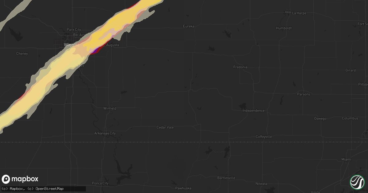
Hail Map in Des Moines, IA on April 14, 2012
Get this storm
April 14 map
$229
one time, instant access
Download today. No call, no setup
Keep the $229
Bought the map and want the full workflow? Apply the entire $229 to a subscription within 7 days. None of it is wasted.
Every map, not just this one
This buys you this map. Subscription and you get every map we run, in the markets you choose from a few cities to whole states to nationwide. Plus real-time alerts the moment a storm fires.
Contact data
Name, contact info, occupancy, even credit band for addresses in the footprint. You go from where it hit to who to call.
Become the source they trust
Unlimited branding weather history reports on demand. You already have the documented answer ready for the property owner, and you are the one who showed up with it.
Property data and RoofTrace estimates
Pull up any address you have got, its value and the exact code rules for that jurisdiction, straight from One Click Code. Then RoofTrace estimates the squares, pitch, and roof value, priced the way you price.
Storm reports in Des Moines, IA
Des Moines, IA
| Date | Description |
|---|---|
| 04/14/20125:27 PM CDT | Located at army post rd and se 5th st. |
| 04/14/20125:25 PM CDT | A local report indicates 1.00 inch wind near S DES MOINES |
| 04/14/20125:19 PM CDT | Report from des moines international airport. Hail fell from 519 pm until 537 pm. Largest hail was 1 inch. |
| 04/13/20128:02 PM CDT | Large trees down near 18th and woodlawn and near sherman hoyt area. Significant tree damage reported. Media report relayed by woi tv. |
| 04/13/20127:58 PM CDT | Tree limbs down. |
| 04/13/20127:53 PM CDT | 10 inch diameter limbs down along east 18th street. |
| 04/13/20127:51 PM CDT | South wind at 65 mph at blank park zoo in south des moines. |
| 04/13/20127:50 PM CDT | Power lines down...power outages...4-5 inches running water in streets due to heavy rainfall. |
All States Impacted by Hail Map on April 14, 2012
All Cities Impacted by Hail Map on April 14, 2012
- Burwell, NE
- Bazine, KS
- Oskaloosa, IA
- University Park, IA
- Buffalo, OK
- Yarmouth, IA
- Milan, IL
- Joy, IL
- New London, IA
- Blue Grass, IA
- Davenport, IA
- Wapello, IA
- Andalusia, IL
- Morning Sun, IA
- Illinois City, IL
- Reynolds, IL
- Montpelier, IA
- Salem, IA
- Mount Union, IA
- Muscatine, IA
- Aledo, IL
- Mount Pleasant, IA
- Taylor Ridge, IL
- New Boston, IL
- Mediapolis, IA
- Buffalo, IA
- Mclean, TX
- Lelia Lake, TX
- Wellington, TX
- Hedley, TX
- Higgins, TX
- Shattuck, OK
- Arnett, OK
- Tipton, IA
- West Branch, IA
- Downs, KS
- Luray, KS
- Otis, KS
- Esbon, KS
- Victoria, KS
- Bunker Hill, KS
- Gaylord, KS
- Russell, KS
- Guide Rock, NE
- Superior, NE
- Mankato, KS
- Osborne, KS
- Nelson, NE
- Waldo, KS
- Burr Oak, KS
- Pfeifer, KS
- Lucas, KS
- Paradise, KS
- Gorham, KS
- Ohiowa, NE
- Lakeview, TX
- Quail, TX
- Shamrock, TX
- Memphis, TX
- Clay Center, KS
- Anselmo, NE
- Oakdale, NE
- Tilden, NE
- Newman Grove, NE
- Petersburg, NE
- Albion, NE
- Meadow Grove, NE
- Elgin, NE
- Durham, OK
- Gage, OK
- Protection, KS
- Hardtner, KS
- Mooreland, OK
- Coldwater, KS
- Plainview, TX
- Quitaque, TX
- Silverton, TX
- Medicine Lodge, KS
- Sharon, OK
- Fargo, OK
- Lake City, KS
- Woodward, OK
- Clarendon, TX
- Alva, OK
- Reydon, OK
- Canadian, TX
- Mobeetie, TX
- Wilmore, KS
- Laverne, OK
- Lockney, TX
- Briscoe, TX
- Fort Supply, OK
- May, OK
- Petersburg, TX
- Freedom, OK
- Crawford, OK
- Wheeler, TX
- Central City, NE
- Palmer, NE
- Archer, NE
- Oak, NE
- Seward, NE
- Pleasant Dale, NE
- Garland, NE
- Malcolm, NE
- Raymond, NE
- Ford, KS
- Dodge City, KS
- Spearville, KS
- Wright, KS
- Andover, KS
- Justiceburg, TX
- Idalou, TX
- Lubbock, TX
- Sun City, KS
- Wolfforth, TX
- Greensburg, KS
- Mason City, NE
- Burdett, KS
- Rush Center, KS
- Nekoma, KS
- Bison, KS
- La Crosse, KS
- Rozel, KS
- Hanston, KS
- Elk City, OK
- Brewster, NE
- Arnold, NE
- Taylor, NE
- Sargent, NE
- Dunning, NE
- Sergeant Bluff, IA
- Winnebago, NE
- Homer, NE
- Salix, IA
- Wakeeney, KS
- Ogallah, KS
- Ellis, KS
- Palco, KS
- Bogue, KS
- Damar, KS
- Hastings, IA
- Malvern, IA
- Imogene, IA
- Randolph, IA
- Cherokee, OK
- Stapleton, NE
- Bartlett, NE
- Chambers, NE
- Cedar, IA
- Bussey, IA
- Eddyville, IA
- Fremont, IA
- Ozona, TX
- Midkiff, TX
- Afton, IA
- New Virginia, IA
- Shannon City, IA
- Osceola, IA
- Grand River, IA
- Lorimor, IA
- Ellston, IA
- Creston, IA
- Truro, IA
- Tingley, IA
- Lenox, IA
- Diagonal, IA
- Murray, IA
- Thayer, IA
- Mullinville, KS
- Bucklin, KS
- Magnet, NE
- Osmond, NE
- Creighton, NE
- Randolph, NE
- Crofton, NE
- Bloomfield, NE
- Wausa, NE
- Hartington, NE
- Plainview, NE
- Mclean, NE
- Cunningham, KS
- Pratt, KS
- Nashville, KS
- Follett, TX
- Isabel, KS
- Coats, KS
- Haviland, KS
- Sawyer, KS
- Friend, NE
- Exeter, NE
- Fairmont, NE
- Ollie, IA
- Hedrick, IA
- Fairfield, NE
- Leonardville, KS
- Riley, KS
- Green, KS
- Maxwell, NE
- Gail, TX
- Crosbyton, TX
- Floydada, TX
- Richland, IA
- Silvis, IL
- East Moline, IL
- Sidney, IA
- Tabor, IA
- Percival, IA
- Thurman, IA
- Callaway, NE
- Broken Bow, NE
- Oconto, NE
- Wakefield, KS
- Glenvil, NE
- Juniata, NE
- Salina, KS
- Snyder, TX
- Vermillion, KS
- Frankfort, KS
- Brookville, KS
- Falun, KS
- Lindsborg, KS
- Carter, OK
- Great Bend, KS
- Albert, KS
- Dacoma, OK
- Burns, KS
- Derby, KS
- Wichita, KS
- Clearwater, KS
- Conway Springs, KS
- Milan, KS
- Amorita, OK
- Peck, KS
- Danville, KS
- Freeport, KS
- Benton, KS
- Rose Hill, KS
- Vici, OK
- Potwin, KS
- Burlington, OK
- Anthony, KS
- Bluff City, KS
- Viola, KS
- Caldwell, KS
- Waynoka, OK
- Waldron, KS
- Cassoday, KS
- Matfield Green, KS
- Aline, OK
- Augusta, KS
- Chester, OK
- Harper, KS
- Haysville, KS
- Mcconnell Afb, KS
- Mutual, OK
- Towanda, KS
- Carmen, OK
- Manchester, OK
- Argonia, KS
- El Dorado, KS
- Slaton, TX
- Hiawatha, KS
- White Cloud, KS
- Blackwell, TX
- Concordia, KS
- Beloit, KS
- Olmitz, KS
- Jamestown, KS
- Randall, KS
- Belleville, KS
- Hoisington, KS
- Dorrance, KS
- Jewell, KS
- Norway, KS
- Courtland, KS
- Barnard, KS
- Scandia, KS
- Larned, KS
- Sylvan Grove, KS
- Hunter, KS
- Pawnee Rock, KS
- Seagraves, TX
- Blair, NE
- Lewis, KS
- Kinsley, KS
- Ericson, NE
- Ayr, NE
- Hastings, NE
- Cedar Bluffs, NE
- Colon, NE
- Edison, NE
- McCool Junction, NE
- Cleveland, OK
- Beaver City, NE
- Bertrand, NE
- Hendley, NE
- Arapahoe, NE
- Oxford, NE
- Dixon, IL
- Lenora, KS
- Minneola, KS
- Fowler, KS
- Meade, KS
- Greenleaf, KS
- Corning, KS
- Wallace, NE
- Carroll, NE
- Norfolk, NE
- Hoskins, NE
- Ord, NE
- Winside, NE
- Pilger, NE
- Arcadia, NE
- Loup City, NE
- Stanton, NE
- Lindsay, NE
- Spalding, NE
- Madison, NE
- North Loup, NE
- Wisner, NE
- Belden, NE
- Battle Creek, NE
- Pierce, NE
- Greeley, NE
- Scotia, NE
- Pender, NE
- Paducah, TX
- Washington, IA
- Wayland, IA
- Crawfordsville, IA
- Ainsworth, IA
- Columbus Junction, IA
- Mound City, MO
- Paton, IA
- Dayton, IA
- Pilot Mound, IA
- Boxholm, IA
- Millbrook, IL
- Sheridan, IL
- Plano, IL
- Sandwich, IL
- Somonauk, IL
- Leland, IL
- Yorkville, IL
- Newark, IL
- Oxford, IA
- Watonga, OK
- Bedford, IA
- Big Lake, TX
- Matador, TX
- Marysville, KS
- Swan, IA
- Elk Creek, NE
- Humboldt, NE
- Burchard, NE
- Steinauer, NE
- Table Rock, NE
- Pawnee City, NE
- Johnson, NE
- Home, KS
- Summerfield, KS
- Liberty, NE
- Blue Rapids, KS
- Auburn, NE
- Brock, NE
- Beattie, KS
- Saronville, NE
- Wellfleet, NE
- North Platte, NE
- Pretty Prairie, KS
- Kingman, KS
- Fairbury, NE
- Alexandria, NE
- Olsburg, KS
- Randolph, KS
- Plainville, KS
- Winterset, IA
- Ensign, KS
- Cimarron, KS
- Centralia, KS
- Seneca, KS
- Kennard, NE
- Washington, NE
- Clarinda, IA
- New Market, IA
- Sharpsburg, IA
- Indianola, IA
- Gravity, IA
- Mount Ayr, IA
- Garden City, KS
- Sublette, KS
- Rule, TX
- Haskell, TX
- Crowell, TX
- Kearney, NE
- Gibbon, NE
- Milford, NE
- Alton, KS
- Agra, KS
- Kensington, KS
- Phillipsburg, KS
- Riverton, NE
- Franklin, NE
- Bloomington, NE
- Edgar, NE
- Crab Orchard, NE
- Newton, IA
- Lawton, IA
- Kingsley, IA
- Hinton, IA
- Naponee, NE
- Republican City, NE
- Marlow, OK
- Dickens, TX
- Osceola, NE
- Oakville, IA
- Smith Center, KS
- Packwood, IA
- Lovilia, IA
- Beacon, IA
- Hamilton, IA
- Ottumwa, IA
- Knoxville, IA
- Albia, IA
- Melrose, IA
- Melcher Dallas, IA
- Tracy, IA
- Chariton, IA
- Columbia, IA
- Kirkville, IA
- Lacona, IA
- Hardy, NE
- Republic, KS
- Deshler, NE
- Ackerly, TX
- Abilene, TX
- Lucas, IA
- Woodburn, IA
- Holdrege, NE
- Elwood, NE
- Atlanta, NE
- Loomis, NE
- Smithfield, NE
- Orleans, NE
- Norton, KS
- Wilsonville, NE
- Pleasantville, IA
- Milo, IA
- Butler, OK
- Hammon, OK
- Tahoka, TX
- Odonnell, TX
- Cedar Rapids, IA
- Robert Lee, TX
- Morrowville, KS
- Jansen, NE
- Endicott, NE
- Haddam, KS
- Mahaska, KS
- Diller, NE
- Oswego, IL
- Russell, IA
- Columbus, NE
- Lamesa, TX
- Hays, KS
- Lincoln, NE
- Lenorah, TX
- Knott, TX
- Williamson, IA
- Leighton, IA
- Minneapolis, KS
- Tescott, KS
- Utica, KS
- Beaver, OK
- Moundridge, KS
- Ralls, TX
- Wilcox, NE
- Erie, IL
- Prophetstown, IL
- Hopkins, MO
- Logan, KS
- Campbell, NE
- Goehner, NE
- Dorchester, NE
- Stockton, KS
- Prairie View, KS
- Inavale, NE
- Deweese, NE
- Roseland, NE
- Ashland, NE
- Henderson, NE
- Glade, KS
- Denton, NE
- Davey, NE
- Harvard, NE
- Beaver Crossing, NE
- Waco, NE
- Geneva, NE
- Holstein, NE
- Greenwood, NE
- York, NE
- Clay Center, NE
- Blue Hill, NE
- Grafton, NE
- Gretna, NE
- Ceresco, NE
- Sutton, NE
- Bladen, NE
- Lawrence, NE
- Waverly, NE
- Inland, NE
- Cordova, NE
- Shelton, NE
- Lincolnville, KS
- Tampa, KS
- Marion, KS
- Wood River, NE
- Caney, KS
- Havana, KS
- Independence, KS
- Almena, KS
- Miles, IA
- Preston, IA
- Mertzon, TX
- Lincoln, KS
- Beeler, KS
- Ness City, KS
- Colfax, IA
- Westmoreland, KS
- Elyria, NE
- Merna, NE
- Orchard, NE
- Gothenburg, NE
- Inman, NE
- Tryon, NE
- Maywood, NE
- Amelia, NE
- Page, NE
- Elsie, NE
- Ewing, NE
- Thedford, NE
- Hershey, NE
- Dickens, NE
- Royal, NE
- Comstock, NE
- Brady, NE
- Nodaway, IA
- Gibson, IA
- Grinnell, IA
- Searsboro, IA
- Otley, IA
- Deep River, IA
- Barnes City, IA
- Montezuma, IA
- Reasnor, IA
- Lynnville, IA
- Sully, IA
- New Sharon, IA
- Pella, IA
- Cawker City, KS
- Glen Elder, KS
- Hill City, KS
- Midland, TX
- Willow, OK
- Mangum, OK
- Vinson, OK
- Turon, KS
- Seiling, OK
- Shickley, NE
- Ruskin, NE
- Carleton, NE
- Davenport, NE
- Dighton, KS
- Bridgewater, IA
- Massena, IA
- Valentine, NE
- Westbrook, TX
- Colorado City, TX
- Seminole, TX
- Meadow, TX
- Wilson, TX
- Ransom Canyon, TX
- Post, TX
- Abernathy, TX
- Mcadoo, TX
- Spur, TX
- Lorenzo, TX
- Welch, TX
- Fluvanna, TX
- Brownfield, TX
- Girard, TX
- Humeston, IA
- Sheridan, MO
- Garden City, TX
- Phillips, NE
- Marquette, NE
- Chapman, NE
- Grand Island, NE
- Brighton, IA
- Batavia, IA
- Fremont, NE
- Arlington, NE
- Valley, NE
- Berwyn, IL
- Chicago, IL
- Summit Argo, IL
- Dannebrog, NE
- Lone Wolf, OK
- Sterling City, TX
- Trumbull, NE
- Alda, NE
- North English, IA
- Hamburg, IA
- Rock Port, MO
- Nebraska City, NE
- Peru, NE
- Seymour, TX
- Kenesaw, NE
- Heartwell, NE
- Eddyville, NE
- Nehawka, NE
- Murray, NE
- Grant, IA
- Pleasant Hill, IA
- Essex, IA
- Shenandoah, IA
- Des Moines, IA
- Villisca, IA
- Orient, IA
- Stanton, IA
- Farragut, IA
- Greenfield, IA
- West Des Moines, IA
- Cumming, IA
- Red Oak, IA
- Cumberland, IA
- Carbon, IA
- Norwalk, IA
- Earlham, IA
- Fontanelle, IA
- Elliott, IA
- Emerson, IA
- Corning, IA
- Prescott, IA
- Riverton, IA
- Prole, IA
- Dexter, IA
- Van Meter, IA
- Tecumseh, NE
- Cook, NE
- Long Island, KS
- Funk, NE
- Hinsdale, IL
- Western Springs, IL
- Narka, KS
- Morland, KS
- Cee Vee, TX
- Unadilla, NE
- Elmwood, NE
- Eagle, NE
- Palmyra, NE
- Ransom, KS
- Sheffield, TX
- Strang, NE
- Solomon, KS
- Litchfield, NE
- Sumner, NE
- Lexington, NE
- Ansley, NE
- Hillsboro, KS
- Lost Springs, KS
- Ramona, KS
- Manhattan, KS
- Blanchard, IA
- Martinsburg, IA
- Clearfield, IA
- Delta, IA
- Weldon, IA
- Derby, IA
- Coin, IA
- Fairfield, IA
- Chillicothe, IA
- Harvey, IA
- Braddyville, IA
- Sigourney, IA
- Northboro, IA
- Skiatook, OK
- Kiowa, KS
- Axtell, NE
- Clifton, KS
- Clyde, KS
- Agenda, KS
- Hildreth, NE
- Upland, NE
- Minden, NE
- Genoa, NE
- Saint Edward, NE
- Wahoo, NE
- Malmo, NE
- Clyde, TX
- Garfield, KS
- Oregon, MO
- Big Spring, TX
- Coahoma, TX
- Spivey, KS
- Menno, SD
- Freeman, SD
- Talmage, NE
- Assaria, KS
- Geneseo, KS
- Little River, KS
- Hudson, KS
- Raymond, KS
- Ellinwood, KS
- Lyons, KS
- Junction City, KS
- Chapman, KS
- Marquette, KS
- Abilene, KS
- Ellsworth, KS
- New Cambria, KS
- Chase, KS
- Stuart, NE
- Atkinson, NE
- Bassett, NE
- Belvidere, NE
- Hebron, NE
- Palmer, KS
- Linn, KS
- Morganville, KS
- Cheyenne, OK
- Burlingame, KS
- Reading, KS
- Osage City, KS
- Stanton, TX
- Balko, OK
- Ramona, OK
- Bartlesville, OK
- Louisville, NE
- Council Bluffs, IA
- Glenwood, IA
- Plainfield, IL
- Aurora, IL
- Millington, IL
- Earlville, IL
- Naperville, IL
- Montgomery, IL
- Saint Paul, NE
- Wolbach, NE
- Roaring Springs, TX
- Moline, IL
- Sayre, OK
- Sweetwater, OK
- Gilman, IA
- Quanah, TX
- Canton, KS
- Galva, KS
- Granite, OK
- Walthill, NE
- Burrton, KS
- Haven, KS
- Milledgeville, IL
- Onaga, KS
- Bevington, IA
- Saint Charles, IA
- Jetmore, KS
- Woodston, KS
- Reynolds, NE
- Englewood, KS
- Ochelata, OK
- Pawhuska, OK
- Burbank, OK
- Lorraine, KS
- Bushton, KS
- Macksville, KS
- Holliday, TX
- North Liberty, IA
- Solon, IA
- Swisher, IA
- Ely, IA
- Tarzan, TX
- Longford, KS
- Sabetha, KS
- Claflin, KS
- Lehigh, KS
- Buhler, KS
- Herington, KS
- Burdick, KS
- Fairfax, MO
- Havensville, KS
- Goff, KS
- San Angelo, TX
- Avoca, NE
- Syracuse, NE
- Otoe, NE
- Hubbell, NE
- Duncan, OK
- Clearwater, NE
- Coffeyville, KS
- Blue Springs, NE
- Craig, MO
- Forest City, MO
- Robinson, KS
- Ira, TX
- Bennington, NE
- Erick, OK
- Plains, KS
- Penokee, KS
- Fairfax, OK
- Hampton, IL
- Moville, IA
- Malcom, IA
- Loraine, TX
- Stratford, OK
- St John, KS
- Plattsmouth, NE
- Marseilles, IL
- Hennepin, IL
- Seneca, IL
- Ottawa, IL
- Mark, IL
- Oglesby, IL
- Peru, IL
- Cedar Point, IL
- Utica, IL
- Standard, IL
- Granville, IL
- Putnam, IL
- Norcatur, KS
- Bellevue, NE
- Pacific Junction, IA
- Ropesville, TX
- Pisgah, IA
- Glasco, KS
- Barnsdall, OK
- Minooka, IL
- Tipton, KS
- Barnes, KS
- Pleasant Valley, IA
- Port Byron, IL
- Hillsdale, IL
- Coal Valley, IL
- Rock Island, IL
- Colona, IL
- Bettendorf, IA
- Le Claire, IA
- Carbon Cliff, IL
- Rapids City, IL
- Wilson, KS
- Beverly, KS
- Decatur, IA
- Marengo, IA
- Ladora, IA
- Belle Plaine, IA
- Hanover, KS
- Bremen, KS
- Weston, NE
- Valparaiso, NE
- Kellogg, IA
- Omaha, NE
- Yutan, NE
- Waterloo, NE
- Elkhorn, NE
- Blairstown, IA
- Luzerne, IA
- Van Horne, IA
- Asher, OK
- Williamsburg, IA
- Stamford, TX
- Hamlin, TX
- Hesston, KS
- Hutchinson, KS
- Council Grove, KS
- Durham, KS
- Wilsey, KS
- Dwight, KS
- White City, KS
- Afton, TX
- Duke, OK
- Clearmont, MO
- Hayesville, IA
- Elmo, MO
- What Cheer, IA
- Columbus City, IA
- Keswick, IA
- Benton, IA
- Monroe, IA
- Rose Hill, IA
- Verdigre, NE
- Gypsum, KS
- Abbyville, KS
- Alta Vista, KS
- Plevna, KS
- Milton, KS
- Arlington, KS
- Wellington, KS
- Mayfield, KS
- Zenda, KS
- Byers, KS
- Mulvane, KS
- Canute, OK
- Wetmore, KS
- Milford, KS
- Oneida, KS
- Morrill, KS
- Fairview, KS
- Henderson, IA
- Natoma, KS
- Emporia, KS
- Montezuma, KS
- Delaware, OK
- Childress, TX
- Jayton, TX
- Westerville, NE
- Brownell, KS
- Nowata, OK
- Marion, SD
- Milligan, NE
- Tobias, NE
- Eldorado, OK
- Athol, KS
- Falls City, NE
- Kanopolis, KS
- Bennington, KS
- Dunbar, NE
- Hampton, NE
- Highland, KS
- Bradford, IL
- Silver Creek, NE
- Pickrell, NE
- Gould, OK
- Webber, KS
- Tupelo, OK
- Bruning, NE
- Waterville, KS
- Wymore, NE
- Macksburg, IA
- Tuscola, TX
- Iuka, KS
- Belpre, KS
- Hollenberg, KS
- Julian, NE
- Baileyville, KS
- Beatrice, NE
- Keota, IA
- Blockton, IA
- De Witt, NE
- Salem, NE
- Steele City, NE
- Winfield, IA
- Washington, KS
- College Springs, IA
- Offerle, KS
- Holyrood, KS
- Aurora, KS
- Soldier, KS
- Delphos, KS
- Sylvia, KS
- Axtell, KS
- Westboro, MO
- Plymouth, NE
- Sterling, NE
- Forgan, OK
- Burlington Junction, MO
- Miltonvale, KS
- Olds, IA
- Stuart, IA
- Gate, OK
- Oketo, KS
- Burr, NE
- Cuba, KS
- Blakesburg, IA
- Shambaugh, IA
- Rulo, NE
- Griswold, IA
- Prairie City, IA
- Runnells, IA
- Western, NE
- Altus, OK
- Talala, OK
- Hurdland, MO
- Sentinel, OK
- Paxton, NE
- Watson, MO
- Cedar, KS
- Cedar Rapids, NE
- McCracken, KS
- Roby, TX
- Portis, KS
- Elm Creek, NE
- Springfield, NE
- South Bend, NE
- Alexander, KS
- Aurora, NE
- Collyer, KS
- Murdock, NE
- Alvo, NE
- Walker, KS
- Clinton, OK
- Rutledge, MO
- Lewiston, NE
- Virginia, NE
- Comanche, OK
- Savanna, IL
- Giltner, NE
- Olustee, OK
- Stillwater, OK
- Morrison, OK
- Altoona, IA
- Webster, IA
- La Vista, NE
- Papillion, NE
- Tarkio, MO
- Skidmore, MO
- Waurika, OK
- Brooklyn, IA
- Clarks, NE
- Macomb, OK
- Fullerton, NE
- McCaulley, TX
- Sylvester, TX
- Stroud, OK
- Merkel, TX
- Downers Grove, IL
- Westmont, IL
- Elba, NE
- Firth, NE
- Hickman, NE
- Martell, NE
- Taloga, OK
- Dryden, TX
- Coleridge, NE
- Bee, NE
- Dwight, NE
- Sweetwater, TX
- Cairo, NE
- Iraan, TX
- Rankin, TX
- Galesburg, IL
- Monmouth, IL
- Cameron, IL
- Stromsburg, NE
- Chester, NE
- Toulon, IL
- La Fayette, IL
- Wataga, IL
- Galva, IL
- East Galesburg, IL
- Oneida, IL
- Victoria, IL
- Knoxville, IL
- Hazelton, KS
- Sharon, KS
- Hollis, OK
- Boys Town, NE
- Polk, NE
- Benedict, NE
- Bradshaw, NE
- Lisle, IL
- Sioux Center, IA
- Bennet, NE
- Cambridge, NE
- Doniphan, NE
- Danville, IA
- Loco, OK
- Adams, NE
- Shelby, NE
- Cedar Point, KS
- Harper, IA
- Dodson, TX
- Grant City, MO
- Redding, IA
- Parnell, MO
- Formoso, KS
- Alcester, SD
- Smithland, IA
- Corydon, IA
- Brunswick, NE
- Oneill, NE
- Mead, NE
- Rising City, NE
- Tiffin, IA
- Harcourt, IA
- Anson, TX
- Thurston, NE
- Wakefield, NE
- Emerson, NE
- Munden, KS
- Ackworth, IA
- Odell, NE
- Wilmington, IL


