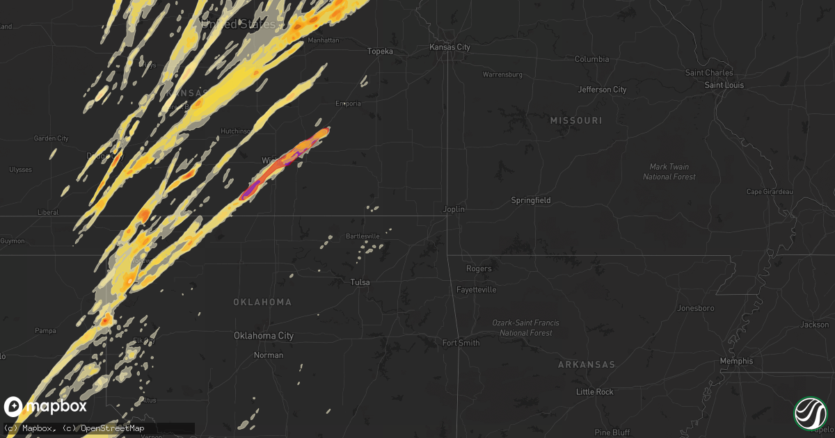
Hail Map in Iowa on April 14, 2012
Get this storm
April 14 map
$229
one time, instant access
Download today. No call, no setup
Keep the $229
Bought the map and want the full workflow? Apply the entire $229 to a subscription within 7 days. None of it is wasted.
Every map, not just this one
This buys you this map. Subscription and you get every map we run, in the markets you choose from a few cities to whole states to nationwide. Plus real-time alerts the moment a storm fires.
Contact data
Name, contact info, occupancy, even credit band for addresses in the footprint. You go from where it hit to who to call.
Become the source they trust
Unlimited branding weather history reports on demand. You already have the documented answer ready for the property owner, and you are the one who showed up with it.
Property data and RoofTrace estimates
Pull up any address you have got, its value and the exact code rules for that jurisdiction, straight from One Click Code. Then RoofTrace estimates the squares, pitch, and roof value, priced the way you price.
Storm reports in Iowa
Iowa
| Date | Description |
|---|---|
| 04/14/20126:57 PM CDT | A local report indicates 1.00 inch wind near 5 SW CRESTON |
| 04/14/20126:55 PM CDT | Large tree knocked down over the road near the intersection of highway 49 and highway 34. |
| 04/14/20126:55 PM CDT | Large tree knocked down over the road near the intersection of highway 49 and highway 34. |
| 04/14/20126:54 PM CDT | A local report indicates 1.25 inch wind near 1 W NEW VIRGINIA |
| 04/14/20126:50 PM CDT | A local report indicates 1.00 inch wind near 5 SW NEW VIRGINIA |
| 04/14/20126:47 PM CDT | Nickel to quarter size hail |
| 04/14/20126:47 PM CDT | A local report indicates 1.00 inch wind near 5 NW OSCEOLA |
| 04/14/20126:44 PM CDT | Shingles blown off home. Small branches broken off. |
| 04/14/20126:10 PM CDT | Gust measured by weather station at 4 ft height. Damage to trees and power poles and some structural damage. |
| 04/14/20125:58 PM CDT | 2 foot diameter trees blown down. |
| 04/14/20125:54 PM CDT | Measured on a home weather station. Tree snapped off just above grade and many limbs snapped and thrown. |
| 04/14/20125:40 PM CDT | 5 semi trucks blown off interstate 29 between mile marker 16 and 18. |
| 04/14/20125:35 PM CDT | 75 percent of the town of thurman was destroyed. The town has been evacuated with an emergency shelter in a nearby town. No power in the town. No major injuries. |
| 04/14/20125:27 PM CDT | Located at army post rd and se 5th st. |
| 04/14/20125:25 PM CDT | A local report indicates 1.00 inch wind near S DES MOINES |
| 04/14/20125:21 PM CDT | A local report indicates 1.00 inch wind near 3 SSW DES MOINES INT AI |
| 04/14/20125:19 PM CDT | Report from des moines international airport. Hail fell from 519 pm until 537 pm. Largest hail was 1 inch. |
| 04/14/20124:41 PM CDT | Wind blowing over road signs. |
| 04/14/20124:31 PM CDT | A local report indicates 1.00 inch wind near 3 W WINTERSET |
| 04/14/20124:30 PM CDT | A local report indicates 1.00 inch wind near 5 E STUART |
| 04/14/20124:30 PM CDT | A local report indicates 1.00 inch wind near 1 WSW WINTERSET |
| 04/14/20124:24 PM CDT | At highway 92 and pitzer road |
| 04/14/20124:15 PM CDT | Damaged to several large trees and roof damage to a building. Time estimated. |
| 04/14/20123:55 PM CDT | Large branches down |
| 04/14/20123:51 PM CDT | Rain-wrapped tornado. Retransmission of report from 352pm. |
| 04/14/20123:13 PM CDT | Storm chaser reports wind damage. Car damage...trees down...transformer blown. Funnel clouds also observed in the area. Delayed report. Time estimated from radar. |
| 04/14/20123:05 PM CDT | Trained spotter reports quarter sized hail has been falling for about five minutes. |
| 04/14/20123:00 PM CDT | Farm outbuilding destroyed by either wind or torando. The event was not observed. |
| 04/14/20122:59 PM CDT | An ef0 tornado briefly touched down about 6.25 miles northwest of castana. |
| 04/14/20122:50 PM CDT | A local report indicates 1.00 inch wind near 2 SW GRANT |
| 04/14/20122:32 PM CDT | A local report indicates 1.75 inch wind near COBURG |
| 04/14/20122:28 PM CDT | An ef0 tornado briefly touched down about 6.25 miles northwest of castana. |
| 04/14/20121:50 PM CDT | A local report indicates 1.00 inch wind near E RANDOLPH |
| 04/14/20121:05 AM CDT | Damage near the westfair amphitheatre...then east northeast for a mile or two. |
| 04/13/201210:20 PM CDT | Pea sized along with quarter sized hail. |
| 04/13/201210:04 PM CDT | Trees down. |
| 04/13/20129:56 PM CDT | Also 50 to 60 mph winds estimated. |
| 04/13/20129:56 PM CDT | Estimated 50 to 60 mph. Hail up to size of half dollars. |
| 04/13/20129:35 PM CDT | Approx 10 homes damaged in hedrick along with rural farmsteads. Deputy police car was turned around and fell into a ditch. Trees down. Delayed report. |
| 04/13/20129:30 PM CDT | From approximately 930 pm to 945 pm some power lines were blown down and some wind damage occurred from 4 miles west of hedrick eastward along highway 78 to ollie. The |
| 04/13/20129:23 PM CDT | The tornado was determined to be an ef1 tornado with a broad and intense rear flank downdraft south of the track. Thank you mahaska county emergency management for the |
| 04/13/20129:22 PM CDT | Measured by awos site at the airport. Time estimated from radar. |
| 04/13/20129:15 PM CDT | Est. Wind gust to 60 mph. Pea size hail also reported. |
| 04/13/20129:15 PM CDT | Delayed report from april 14. A tree fell on a house on 11th street near 2nd avenue in belle plaine. Relayed by a spotter. Time estimated. |
| 04/13/20129:07 PM CDT | Golfball size hail |
| 04/13/20129:07 PM CDT | Quarter size hail and est. 60 to 70 mph wind gusts. |
| 04/13/20129:05 PM CDT | A local report indicates 1.50 inch wind near EDDYVILLE |
| 04/13/20129:02 PM CDT | Quarter size hail |
| 04/13/20129:00 PM CDT | A local report indicates 2.50 inch wind near 4 SW EDDYVILLE |
| 04/13/20128:50 PM CDT | A local report indicates 60 MPH wind near 1 WSW SEARSBORO |
| 04/13/20128:49 PM CDT | Roof blown off house. Garage blown down. |
| 04/13/20128:45 PM CDT | Quarter size hail... Partially covering the ground |
| 04/13/20128:43 PM CDT | 3 to 8 inch tree limbs down at valley junction. |
| 04/13/20128:30 PM CDT | Garage attached to a house destroyed and partial roof loss to the house. Debris from the house strewn eastward downwind of the house for over 100 yards. Garage door...w |
| 04/13/20128:29 PM CDT | Quarter sized hail along with estimated 60 mph wind gusts. |
| 04/13/20128:29 PM CDT | Trees down and dime size hail reported. |
| 04/13/20128:28 PM CDT | Siding ripped off house. Small hail also reported |
| 04/13/20128:23 PM CDT | Steel shed blown away |
| 04/13/20128:21 PM CDT | A local report indicates 1.75 inch wind near 5 W CHARITON AIRPORT |
| 04/13/20128:02 PM CDT | Large trees down near 18th and woodlawn and near sherman hoyt area. Significant tree damage reported. Media report relayed by woi tv. |
| 04/13/20128:02 PM CDT | A local report indicates 60 MPH wind near 2 ENE URBANDALE |
| 04/13/20128:00 PM CDT | Most of roof torn away from a commercial building. Time estimated from radar. |
| 04/13/20127:59 PM CDT | Small branches broken off. Minor street flooding. |
| 04/13/20127:58 PM CDT | Tree limbs down. |
| 04/13/20127:55 PM CDT | Brief ef1 tornado confirmed by nws damage survey. The tornado touched down three miles east of new virginia and tracked one mile to the east before dissipating. The tor |
| 04/13/20127:55 PM CDT | 60 to 65 mph winds...no damage reports yet. Wind lasted about 10 mph. |
| 04/13/20127:55 PM CDT | Possible tornado damage east of new virgina. Campers and farm outbuildings damaged. Sheet metal lying around. Time estimated from radar. |
| 04/13/20127:53 PM CDT | 10 inch diameter limbs down along east 18th street. |
| 04/13/20127:51 PM CDT | South wind at 65 mph at blank park zoo in south des moines. |
| 04/13/20127:51 PM CDT | A local report indicates 60 MPH wind near 1 W OSCEOLA |
| 04/13/20127:50 PM CDT | Small tree blown over. Time estimated from radar. |
| 04/13/20127:50 PM CDT | Power lines down...power outages...4-5 inches running water in streets due to heavy rainfall. |
| 04/13/20127:46 PM CDT | And ... 50 to 60 mph from the southwest. |
| 04/13/20127:45 PM CDT | 12-13 tree snapped at base. |
| 04/13/20127:44 PM CDT | Reported north of the jordan creek mall. |
| 04/13/20127:39 PM CDT | A local report indicates 70 MPH wind near 4 S DALLAS CENTER |
| 04/13/20127:39 PM CDT | A local report indicates 60 MPH wind near 4 NNW OSCEOLA |
| 04/13/20127:37 PM CDT | Tornado on the ground. Looking northwest from lakeside casino near osceola. |
| 04/13/20127:30 PM CDT | Estimated 60 mph gust at intersection of highways 169 and 92 on west side of winterset. |
| 04/13/20127:30 PM CDT | Dime to quarter size hail. 1.67 inches of rain in an hour and twenty minutes also. |
| 04/13/20127:29 PM CDT | A local report indicates 2.75 inch wind near MURRAY |
| 04/13/20127:24 PM CDT | 20 inch trees down. Structural and roof damage to hospital. Large trees uprooted. |
| 04/13/20127:20 PM CDT | A local report indicates 1.75 inch wind near 5 SW LORIMOR |
| 04/13/20127:00 PM CDT | Measured 1.2 inches after melting for a few minutes. |
| 04/13/20127:00 PM CDT | Nws storm survey confirmed strong ef2 tornado. The tornado began about one and a half miles east of cromwell and tracked northeastward through the far northwest portion |
All States Impacted by Hail Map on April 14, 2012
Cities Impacted by Hail Map on April 14, 2012
- Burwell, NE
- Bazine, KS
- Oskaloosa, IA
- University Park, IA
- Buffalo, OK
- Yarmouth, IA
- Milan, IL
- Joy, IL
- New London, IA
- Blue Grass, IA
- Davenport, IA
- Wapello, IA
- Andalusia, IL
- Morning Sun, IA
- Illinois City, IL
- Reynolds, IL
- Montpelier, IA
- Salem, IA
- Mount Union, IA
- Muscatine, IA
- Aledo, IL
- Mount Pleasant, IA
- Taylor Ridge, IL
- New Boston, IL
- Mediapolis, IA
- Buffalo, IA
- Mclean, TX
- Lelia Lake, TX
- Wellington, TX
- Hedley, TX
- Higgins, TX
- Shattuck, OK
- Arnett, OK
- Tipton, IA
- West Branch, IA
- Downs, KS
- Luray, KS
- Otis, KS
- Esbon, KS
- Victoria, KS
- Bunker Hill, KS
- Gaylord, KS
- Russell, KS
- Guide Rock, NE
- Superior, NE
- Mankato, KS
- Osborne, KS
- Nelson, NE
- Waldo, KS
- Burr Oak, KS
- Pfeifer, KS
- Lucas, KS
- Paradise, KS
- Gorham, KS
- Ohiowa, NE
- Lakeview, TX
- Quail, TX
- Shamrock, TX
- Memphis, TX
- Clay Center, KS
- Anselmo, NE
- Oakdale, NE
- Tilden, NE
- Newman Grove, NE
- Petersburg, NE
- Albion, NE
- Meadow Grove, NE
- Elgin, NE
- Durham, OK
- Gage, OK
- Protection, KS
- Hardtner, KS
- Mooreland, OK
- Coldwater, KS
- Plainview, TX
- Quitaque, TX
- Silverton, TX
- Medicine Lodge, KS
- Sharon, OK
- Fargo, OK
- Lake City, KS
- Woodward, OK
- Clarendon, TX
- Alva, OK
- Reydon, OK
- Canadian, TX
- Mobeetie, TX
- Wilmore, KS
- Laverne, OK
- Lockney, TX
- Briscoe, TX
- Fort Supply, OK
- May, OK
- Petersburg, TX
- Freedom, OK
- Crawford, OK
- Wheeler, TX
- Central City, NE
- Palmer, NE
- Archer, NE
- Oak, NE
- Seward, NE
- Pleasant Dale, NE
- Garland, NE
- Malcolm, NE
- Raymond, NE
- Ford, KS
- Dodge City, KS
- Spearville, KS
- Wright, KS
- Andover, KS
- Justiceburg, TX
- Idalou, TX
- Lubbock, TX
- Sun City, KS
- Wolfforth, TX
- Greensburg, KS
- Mason City, NE
- Burdett, KS
- Rush Center, KS
- Nekoma, KS
- Bison, KS
- La Crosse, KS
- Rozel, KS
- Hanston, KS
- Elk City, OK
- Brewster, NE
- Arnold, NE
- Taylor, NE
- Sargent, NE
- Dunning, NE
- Sergeant Bluff, IA
- Winnebago, NE
- Homer, NE
- Salix, IA
- Wakeeney, KS
- Ogallah, KS
- Ellis, KS
- Palco, KS
- Bogue, KS
- Damar, KS
- Hastings, IA
- Malvern, IA
- Imogene, IA
- Randolph, IA
- Cherokee, OK
- Stapleton, NE
- Bartlett, NE
- Chambers, NE
- Cedar, IA
- Bussey, IA
- Eddyville, IA
- Fremont, IA
- Ozona, TX
- Midkiff, TX
- Afton, IA
- New Virginia, IA
- Shannon City, IA
- Osceola, IA
- Grand River, IA
- Lorimor, IA
- Ellston, IA
- Creston, IA
- Truro, IA
- Tingley, IA
- Lenox, IA
- Diagonal, IA
- Murray, IA
- Thayer, IA
- Mullinville, KS
- Bucklin, KS
- Magnet, NE
- Osmond, NE
- Creighton, NE
- Randolph, NE
- Crofton, NE
- Bloomfield, NE
- Wausa, NE
- Hartington, NE
- Plainview, NE
- Mclean, NE
- Cunningham, KS
- Pratt, KS
- Nashville, KS
- Follett, TX
- Isabel, KS
- Coats, KS
- Haviland, KS
- Sawyer, KS
- Friend, NE
- Exeter, NE
- Fairmont, NE
- Ollie, IA
- Hedrick, IA
- Fairfield, NE
- Leonardville, KS
- Riley, KS
- Green, KS
- Maxwell, NE
- Gail, TX
- Crosbyton, TX
- Floydada, TX
- Richland, IA
- Silvis, IL
- East Moline, IL
- Sidney, IA
- Tabor, IA
- Percival, IA
- Thurman, IA
- Callaway, NE
- Broken Bow, NE
- Oconto, NE
- Wakefield, KS
- Glenvil, NE
- Juniata, NE
- Salina, KS
- Snyder, TX
- Vermillion, KS
- Frankfort, KS
- Brookville, KS
- Falun, KS
- Lindsborg, KS
- Carter, OK
- Great Bend, KS
- Albert, KS
- Dacoma, OK
- Burns, KS
- Derby, KS
- Wichita, KS
- Clearwater, KS
- Conway Springs, KS
- Milan, KS
- Amorita, OK
- Peck, KS
- Danville, KS
- Freeport, KS
- Benton, KS
- Rose Hill, KS
- Vici, OK
- Potwin, KS
- Burlington, OK
- Anthony, KS
- Bluff City, KS
- Viola, KS
- Caldwell, KS
- Waynoka, OK
- Waldron, KS
- Cassoday, KS
- Matfield Green, KS
- Aline, OK
- Augusta, KS
- Chester, OK
- Harper, KS
- Haysville, KS
- Mcconnell Afb, KS
- Mutual, OK
- Towanda, KS
- Carmen, OK
- Manchester, OK
- Argonia, KS
- El Dorado, KS
- Slaton, TX
- Hiawatha, KS
- White Cloud, KS
- Blackwell, TX
- Concordia, KS
- Beloit, KS
- Olmitz, KS
- Jamestown, KS
- Randall, KS
- Belleville, KS
- Hoisington, KS
- Dorrance, KS
- Jewell, KS
- Norway, KS
- Courtland, KS
- Barnard, KS
- Scandia, KS
- Larned, KS
- Sylvan Grove, KS
- Hunter, KS
- Pawnee Rock, KS
- Seagraves, TX
- Blair, NE
- Lewis, KS
- Kinsley, KS
- Ericson, NE
- Ayr, NE
- Hastings, NE
- Cedar Bluffs, NE
- Colon, NE
- Edison, NE
- McCool Junction, NE
- Cleveland, OK
- Beaver City, NE
- Bertrand, NE
- Hendley, NE
- Arapahoe, NE
- Oxford, NE
- Dixon, IL
- Lenora, KS
- Minneola, KS
- Fowler, KS
- Meade, KS
- Greenleaf, KS
- Corning, KS
- Wallace, NE
- Carroll, NE
- Norfolk, NE
- Hoskins, NE
- Ord, NE
- Winside, NE
- Pilger, NE
- Arcadia, NE
- Loup City, NE
- Stanton, NE
- Lindsay, NE
- Spalding, NE
- Madison, NE
- North Loup, NE
- Wisner, NE
- Belden, NE
- Battle Creek, NE
- Pierce, NE
- Greeley, NE
- Scotia, NE
- Pender, NE
- Paducah, TX
- Washington, IA
- Wayland, IA
- Crawfordsville, IA
- Ainsworth, IA
- Columbus Junction, IA
- Mound City, MO
- Paton, IA
- Dayton, IA
- Pilot Mound, IA
- Boxholm, IA
- Millbrook, IL
- Sheridan, IL
- Plano, IL
- Sandwich, IL
- Somonauk, IL
- Leland, IL
- Yorkville, IL
- Newark, IL
- Oxford, IA
- Watonga, OK
- Bedford, IA
- Big Lake, TX
- Matador, TX
- Marysville, KS
- Swan, IA
- Elk Creek, NE
- Humboldt, NE
- Burchard, NE
- Steinauer, NE
- Table Rock, NE
- Pawnee City, NE
- Johnson, NE
- Home, KS
- Summerfield, KS
- Liberty, NE
- Blue Rapids, KS
- Auburn, NE
- Brock, NE
- Beattie, KS
- Saronville, NE
- Wellfleet, NE
- North Platte, NE
- Pretty Prairie, KS
- Kingman, KS
- Fairbury, NE
- Alexandria, NE
- Olsburg, KS
- Randolph, KS
- Plainville, KS
- Winterset, IA
- Ensign, KS
- Cimarron, KS
- Centralia, KS
- Seneca, KS
- Kennard, NE
- Washington, NE
- Clarinda, IA
- New Market, IA
- Sharpsburg, IA
- Indianola, IA
- Gravity, IA
- Mount Ayr, IA
- Garden City, KS
- Sublette, KS
- Rule, TX
- Haskell, TX
- Crowell, TX
- Kearney, NE
- Gibbon, NE
- Milford, NE
- Alton, KS
- Agra, KS
- Kensington, KS
- Phillipsburg, KS
- Riverton, NE
- Franklin, NE
- Bloomington, NE
- Edgar, NE
- Crab Orchard, NE
- Newton, IA
- Lawton, IA
- Kingsley, IA
- Hinton, IA
- Naponee, NE
- Republican City, NE
- Marlow, OK
- Dickens, TX
- Osceola, NE
- Oakville, IA
- Smith Center, KS
- Packwood, IA
- Lovilia, IA
- Beacon, IA
- Hamilton, IA
- Ottumwa, IA
- Knoxville, IA
- Albia, IA
- Melrose, IA
- Melcher Dallas, IA
- Tracy, IA
- Chariton, IA
- Columbia, IA
- Kirkville, IA
- Lacona, IA
- Hardy, NE
- Republic, KS
- Deshler, NE
- Ackerly, TX
- Abilene, TX
- Lucas, IA
- Woodburn, IA
- Holdrege, NE
- Elwood, NE
- Atlanta, NE
- Loomis, NE
- Smithfield, NE
- Orleans, NE
- Norton, KS
- Wilsonville, NE
- Pleasantville, IA
- Milo, IA
- Butler, OK
- Hammon, OK
- Tahoka, TX
- Odonnell, TX
- Cedar Rapids, IA
- Robert Lee, TX
- Morrowville, KS
- Jansen, NE
- Endicott, NE
- Haddam, KS
- Mahaska, KS
- Diller, NE
- Oswego, IL
- Russell, IA
- Columbus, NE
- Lamesa, TX
- Hays, KS
- Lincoln, NE
- Lenorah, TX
- Knott, TX
- Williamson, IA
- Leighton, IA
- Minneapolis, KS
- Tescott, KS
- Utica, KS
- Beaver, OK
- Moundridge, KS
- Ralls, TX
- Wilcox, NE
- Erie, IL
- Prophetstown, IL
- Hopkins, MO
- Logan, KS
- Campbell, NE
- Goehner, NE
- Dorchester, NE
- Stockton, KS
- Prairie View, KS
- Inavale, NE
- Deweese, NE
- Roseland, NE
- Ashland, NE
- Henderson, NE
- Glade, KS
- Denton, NE
- Davey, NE
- Harvard, NE
- Beaver Crossing, NE
- Waco, NE
- Geneva, NE
- Holstein, NE
- Greenwood, NE
- York, NE
- Clay Center, NE
- Blue Hill, NE
- Grafton, NE
- Gretna, NE
- Ceresco, NE
- Sutton, NE
- Bladen, NE
- Lawrence, NE
- Waverly, NE
- Inland, NE
- Cordova, NE
- Shelton, NE
- Lincolnville, KS
- Tampa, KS
- Marion, KS
- Wood River, NE
- Caney, KS
- Havana, KS
- Independence, KS
- Almena, KS
- Miles, IA
- Preston, IA
- Mertzon, TX
- Lincoln, KS
- Beeler, KS
- Ness City, KS
- Colfax, IA
- Westmoreland, KS
- Elyria, NE
- Merna, NE
- Orchard, NE
- Gothenburg, NE
- Inman, NE
- Tryon, NE
- Maywood, NE
- Amelia, NE
- Page, NE
- Elsie, NE
- Ewing, NE
- Thedford, NE
- Hershey, NE
- Dickens, NE
- Royal, NE
- Comstock, NE
- Brady, NE
- Nodaway, IA
- Gibson, IA
- Grinnell, IA
- Searsboro, IA
- Otley, IA
- Deep River, IA
- Barnes City, IA
- Montezuma, IA
- Reasnor, IA
- Lynnville, IA
- Sully, IA
- New Sharon, IA
- Pella, IA
- Cawker City, KS
- Glen Elder, KS
- Hill City, KS
- Midland, TX
- Willow, OK
- Mangum, OK
- Vinson, OK
- Turon, KS
- Seiling, OK
- Shickley, NE
- Ruskin, NE
- Carleton, NE
- Davenport, NE
- Dighton, KS
- Bridgewater, IA
- Massena, IA
- Valentine, NE
- Westbrook, TX
- Colorado City, TX
- Seminole, TX
- Meadow, TX
- Wilson, TX
- Ransom Canyon, TX
- Post, TX
- Abernathy, TX
- Mcadoo, TX
- Spur, TX
- Lorenzo, TX
- Welch, TX
- Fluvanna, TX
- Brownfield, TX
- Girard, TX
- Humeston, IA
- Sheridan, MO
- Garden City, TX
- Phillips, NE
- Marquette, NE
- Chapman, NE
- Grand Island, NE
- Brighton, IA
- Batavia, IA
- Fremont, NE
- Arlington, NE
- Valley, NE
- Berwyn, IL
- Chicago, IL
- Summit Argo, IL
- Dannebrog, NE
- Lone Wolf, OK
- Sterling City, TX
- Trumbull, NE
- Alda, NE
- North English, IA
- Hamburg, IA
- Rock Port, MO
- Nebraska City, NE
- Peru, NE
- Seymour, TX
- Kenesaw, NE
- Heartwell, NE
- Eddyville, NE
- Nehawka, NE
- Murray, NE
- Grant, IA
- Pleasant Hill, IA
- Essex, IA
- Shenandoah, IA
- Des Moines, IA
- Villisca, IA
- Orient, IA
- Stanton, IA
- Farragut, IA
- Greenfield, IA
- West Des Moines, IA
- Cumming, IA
- Red Oak, IA
- Cumberland, IA
- Carbon, IA
- Norwalk, IA
- Earlham, IA
- Fontanelle, IA
- Elliott, IA
- Emerson, IA
- Corning, IA
- Prescott, IA
- Riverton, IA
- Prole, IA
- Dexter, IA
- Van Meter, IA
- Tecumseh, NE
- Cook, NE
- Long Island, KS
- Funk, NE
- Hinsdale, IL
- Western Springs, IL
- Narka, KS
- Morland, KS
- Cee Vee, TX
- Unadilla, NE
- Elmwood, NE
- Eagle, NE
- Palmyra, NE
- Ransom, KS
- Sheffield, TX
- Strang, NE
- Solomon, KS
- Litchfield, NE
- Sumner, NE
- Lexington, NE
- Ansley, NE
- Hillsboro, KS
- Lost Springs, KS
- Ramona, KS
- Manhattan, KS
- Blanchard, IA
- Martinsburg, IA
- Clearfield, IA
- Delta, IA
- Weldon, IA
- Derby, IA
- Coin, IA
- Fairfield, IA
- Chillicothe, IA
- Harvey, IA
- Braddyville, IA
- Sigourney, IA
- Northboro, IA
- Skiatook, OK
- Kiowa, KS
- Axtell, NE
- Clifton, KS
- Clyde, KS
- Agenda, KS
- Hildreth, NE
- Upland, NE
- Minden, NE
- Genoa, NE
- Saint Edward, NE
- Wahoo, NE
- Malmo, NE
- Clyde, TX
- Garfield, KS
- Oregon, MO
- Big Spring, TX
- Coahoma, TX
- Spivey, KS
- Menno, SD
- Freeman, SD
- Talmage, NE
- Assaria, KS
- Geneseo, KS
- Little River, KS
- Hudson, KS
- Raymond, KS
- Ellinwood, KS
- Lyons, KS
- Junction City, KS
- Chapman, KS
- Marquette, KS
- Abilene, KS
- Ellsworth, KS
- New Cambria, KS
- Chase, KS
- Stuart, NE
- Atkinson, NE
- Bassett, NE
- Belvidere, NE
- Hebron, NE
- Palmer, KS
- Linn, KS
- Morganville, KS
- Cheyenne, OK
- Burlingame, KS
- Reading, KS
- Osage City, KS
- Stanton, TX
- Balko, OK
- Ramona, OK
- Bartlesville, OK
- Louisville, NE
- Council Bluffs, IA
- Glenwood, IA
- Plainfield, IL
- Aurora, IL
- Millington, IL
- Earlville, IL
- Naperville, IL
- Montgomery, IL
- Saint Paul, NE
- Wolbach, NE
- Roaring Springs, TX
- Moline, IL
- Sayre, OK
- Sweetwater, OK
- Gilman, IA
- Quanah, TX
- Canton, KS
- Galva, KS
- Granite, OK
- Walthill, NE
- Burrton, KS
- Haven, KS
- Milledgeville, IL
- Onaga, KS
- Bevington, IA
- Saint Charles, IA
- Jetmore, KS
- Woodston, KS
- Reynolds, NE
- Englewood, KS
- Ochelata, OK
- Pawhuska, OK
- Burbank, OK
- Lorraine, KS
- Bushton, KS
- Macksville, KS
- Holliday, TX
- North Liberty, IA
- Solon, IA
- Swisher, IA
- Ely, IA
- Tarzan, TX
- Longford, KS
- Sabetha, KS
- Claflin, KS
- Lehigh, KS
- Buhler, KS
- Herington, KS
- Burdick, KS
- Fairfax, MO
- Havensville, KS
- Goff, KS
- San Angelo, TX
- Avoca, NE
- Syracuse, NE
- Otoe, NE
- Hubbell, NE
- Duncan, OK
- Clearwater, NE
- Coffeyville, KS
- Blue Springs, NE
- Craig, MO
- Forest City, MO
- Robinson, KS
- Ira, TX
- Bennington, NE
- Erick, OK
- Plains, KS
- Penokee, KS
- Fairfax, OK
- Hampton, IL
- Moville, IA
- Malcom, IA
- Loraine, TX
- Stratford, OK
- St John, KS
- Plattsmouth, NE
- Marseilles, IL
- Hennepin, IL
- Seneca, IL
- Ottawa, IL
- Mark, IL
- Oglesby, IL
- Peru, IL
- Cedar Point, IL
- Utica, IL
- Standard, IL
- Granville, IL
- Putnam, IL
- Norcatur, KS
- Bellevue, NE
- Pacific Junction, IA
- Ropesville, TX
- Pisgah, IA
- Glasco, KS
- Barnsdall, OK
- Minooka, IL
- Tipton, KS
- Barnes, KS
- Pleasant Valley, IA
- Port Byron, IL
- Hillsdale, IL
- Coal Valley, IL
- Rock Island, IL
- Colona, IL
- Bettendorf, IA
- Le Claire, IA
- Carbon Cliff, IL
- Rapids City, IL
- Wilson, KS
- Beverly, KS
- Decatur, IA
- Marengo, IA
- Ladora, IA
- Belle Plaine, IA
- Hanover, KS
- Bremen, KS
- Weston, NE
- Valparaiso, NE
- Kellogg, IA
- Omaha, NE
- Yutan, NE
- Waterloo, NE
- Elkhorn, NE
- Blairstown, IA
- Luzerne, IA
- Van Horne, IA
- Asher, OK
- Williamsburg, IA
- Stamford, TX
- Hamlin, TX
- Hesston, KS
- Hutchinson, KS
- Council Grove, KS
- Durham, KS
- Wilsey, KS
- Dwight, KS
- White City, KS
- Afton, TX
- Duke, OK
- Clearmont, MO
- Hayesville, IA
- Elmo, MO
- What Cheer, IA
- Columbus City, IA
- Keswick, IA
- Benton, IA
- Monroe, IA
- Rose Hill, IA
- Verdigre, NE
- Gypsum, KS
- Abbyville, KS
- Alta Vista, KS
- Plevna, KS
- Milton, KS
- Arlington, KS
- Wellington, KS
- Mayfield, KS
- Zenda, KS
- Byers, KS
- Mulvane, KS
- Canute, OK
- Wetmore, KS
- Milford, KS
- Oneida, KS
- Morrill, KS
- Fairview, KS
- Henderson, IA
- Natoma, KS
- Emporia, KS
- Montezuma, KS
- Delaware, OK
- Childress, TX
- Jayton, TX
- Westerville, NE
- Brownell, KS
- Nowata, OK
- Marion, SD
- Milligan, NE
- Tobias, NE
- Eldorado, OK
- Athol, KS
- Falls City, NE
- Kanopolis, KS
- Bennington, KS
- Dunbar, NE
- Hampton, NE
- Highland, KS
- Bradford, IL
- Silver Creek, NE
- Pickrell, NE
- Gould, OK
- Webber, KS
- Tupelo, OK
- Bruning, NE
- Waterville, KS
- Wymore, NE
- Macksburg, IA
- Tuscola, TX
- Iuka, KS
- Belpre, KS
- Hollenberg, KS
- Julian, NE
- Baileyville, KS
- Beatrice, NE
- Keota, IA
- Blockton, IA
- De Witt, NE
- Salem, NE
- Steele City, NE
- Winfield, IA
- Washington, KS
- College Springs, IA
- Offerle, KS
- Holyrood, KS
- Aurora, KS
- Soldier, KS
- Delphos, KS
- Sylvia, KS
- Axtell, KS
- Westboro, MO
- Plymouth, NE
- Sterling, NE
- Forgan, OK
- Burlington Junction, MO
- Miltonvale, KS
- Olds, IA
- Stuart, IA
- Gate, OK
- Oketo, KS
- Burr, NE
- Cuba, KS
- Blakesburg, IA
- Shambaugh, IA
- Rulo, NE
- Griswold, IA
- Prairie City, IA
- Runnells, IA
- Western, NE
- Altus, OK
- Talala, OK
- Hurdland, MO
- Sentinel, OK
- Paxton, NE
- Watson, MO
- Cedar, KS
- Cedar Rapids, NE
- McCracken, KS
- Roby, TX
- Portis, KS
- Elm Creek, NE
- Springfield, NE
- South Bend, NE
- Alexander, KS
- Aurora, NE
- Collyer, KS
- Murdock, NE
- Alvo, NE
- Walker, KS
- Clinton, OK
- Rutledge, MO
- Lewiston, NE
- Virginia, NE
- Comanche, OK
- Savanna, IL
- Giltner, NE
- Olustee, OK
- Stillwater, OK
- Morrison, OK
- Altoona, IA
- Webster, IA
- La Vista, NE
- Papillion, NE
- Tarkio, MO
- Skidmore, MO
- Waurika, OK
- Brooklyn, IA
- Clarks, NE
- Macomb, OK
- Fullerton, NE
- McCaulley, TX
- Sylvester, TX
- Stroud, OK
- Merkel, TX
- Downers Grove, IL
- Westmont, IL
- Elba, NE
- Firth, NE
- Hickman, NE
- Martell, NE
- Taloga, OK
- Dryden, TX
- Coleridge, NE
- Bee, NE
- Dwight, NE
- Sweetwater, TX
- Cairo, NE
- Iraan, TX
- Rankin, TX
- Galesburg, IL
- Monmouth, IL
- Cameron, IL
- Stromsburg, NE
- Chester, NE
- Toulon, IL
- La Fayette, IL
- Wataga, IL
- Galva, IL
- East Galesburg, IL
- Oneida, IL
- Victoria, IL
- Knoxville, IL
- Hazelton, KS
- Sharon, KS
- Hollis, OK
- Boys Town, NE
- Polk, NE
- Benedict, NE
- Bradshaw, NE
- Lisle, IL
- Sioux Center, IA
- Bennet, NE
- Cambridge, NE
- Doniphan, NE
- Danville, IA
- Loco, OK
- Adams, NE
- Shelby, NE
- Cedar Point, KS
- Harper, IA
- Dodson, TX
- Grant City, MO
- Redding, IA
- Parnell, MO
- Formoso, KS
- Alcester, SD
- Smithland, IA
- Corydon, IA
- Brunswick, NE
- Oneill, NE
- Mead, NE
- Rising City, NE
- Tiffin, IA
- Harcourt, IA
- Anson, TX
- Thurston, NE
- Wakefield, NE
- Emerson, NE
- Munden, KS
- Ackworth, IA
- Odell, NE
- Wilmington, IL


