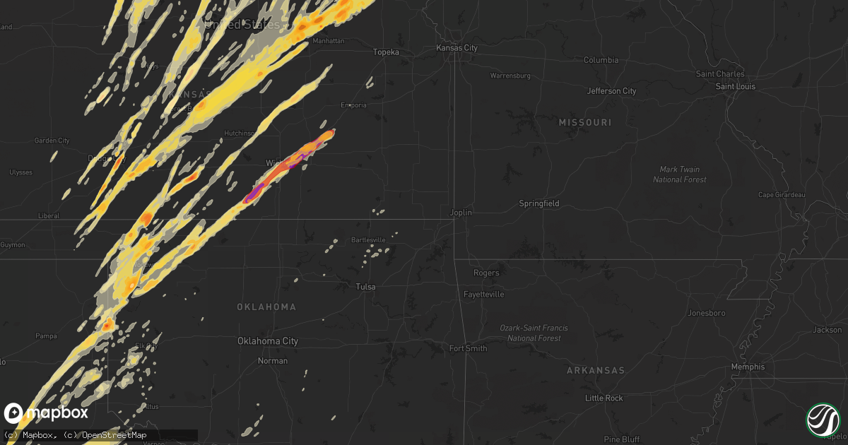
Hail Map in Nebraska on April 14, 2012
Get this storm
April 14 map
$229
one time, instant access
Download today. No call, no setup
Keep the $229
Bought the map and want the full workflow? Apply the entire $229 to a subscription within 7 days. None of it is wasted.
Every map, not just this one
This buys you this map. Subscription and you get every map we run, in the markets you choose from a few cities to whole states to nationwide. Plus real-time alerts the moment a storm fires.
Contact data
Name, contact info, occupancy, even credit band for addresses in the footprint. You go from where it hit to who to call.
Become the source they trust
Unlimited branding weather history reports on demand. You already have the documented answer ready for the property owner, and you are the one who showed up with it.
Property data and RoofTrace estimates
Pull up any address you have got, its value and the exact code rules for that jurisdiction, straight from One Click Code. Then RoofTrace estimates the squares, pitch, and roof value, priced the way you price.
Storm reports in Nebraska
Nebraska
| Date | Description |
|---|---|
| 04/14/20126:55 PM CDT | Time is estimated based off radar. |
| 04/14/20126:53 PM CDT | Most of the hail was pea to quarter size but the largest measured was 1.5 inches. |
| 04/14/20126:50 PM CDT | Ping pong ball sized hail at the lbf weather office. |
| 04/14/20126:43 PM CDT | A local report indicates 1.00 inch wind near NORTH PLATTE |
| 04/14/20126:41 PM CDT | A local report indicates 1.00 inch wind near 7 W ARNOLD |
| 04/14/20126:40 PM CDT | A local report indicates 1.75 inch wind near 1 SW NORTH PLATTE |
| 04/14/20126:37 PM CDT | Law enforcement reported tornado near junction of hwy 23 and hwy 83 6 miles north of wellfleet. |
| 04/14/20126:21 PM CDT | A local report indicates 1.00 inch wind near 8 SW ANSELMO |
| 04/14/20126:16 PM CDT | Confirmed ef-0 tornado on ground from 616-618pm. Estimated winds 65 mph. Path length 3/4 mile. Width 40 yards. Grain bin destroyed near highway 6. |
| 04/14/20126:14 PM CDT | A local report indicates 2.50 inch wind near NORTH PLATTE |
| 04/14/20126:11 PM CDT | Large trees down in the beaver lake area |
| 04/14/20126:10 PM CDT | Brief touchdown. |
| 04/14/20125:50 PM CDT | A local report indicates 1.25 inch wind near 6 NNW OXFORD |
| 04/14/20125:47 PM CDT | Spotter reports tornado just south of flying j truck stop in north platte |
| 04/14/20125:46 PM CDT | A local report indicates 1.00 inch wind near 9 SSW NORTH PLATTE |
| 04/14/20125:39 PM CDT | At hwy 83 and dodge hill road. |
| 04/14/20125:32 PM CDT | Trooper watching tornado approximately 1 mile ssw of north platte. Tornado was approaching state farm road. |
| 04/14/20125:32 PM CDT | Trooper watching tornado approximately 3 miles ssw of north platte. Tornado approaching state farm road. |
| 04/14/20125:30 PM CDT | 6 homes damaged...2 of which may not be livable. 50 to 100 trees in an orchard layed flat a little bit south. Time estimated. |
| 04/14/20125:28 PM CDT | A local report indicates 61 MPH wind near NEBRASKA CITY |
| 04/14/20125:27 PM CDT | Golf ball sized hail in north platte on south chestnut st. |
| 04/14/20125:25 PM CDT | Thin rope tornado on the ground. |
| 04/14/20125:21 PM CDT | Nws storm survey confirmed a tornado touching down 3 miles nw of nebraska city...and continuing to 2.25 miles nnw of nebraska city...lifting at 525 pm. |
| 04/14/20125:13 PM CDT | A local report indicates a tornado near 3 SE COOK |
| 04/14/20125:10 PM CDT | Irrigation pivot destroyed. Trees twisted. Machine shed destroyed. Near intersection of 736 and 629 road. |
| 04/14/20125:10 PM CDT | Significant damage to a home. |
| 04/14/20125:09 PM CDT | A local report indicates 1.00 inch wind near 7 N NORTH PLATTE |
| 04/14/20125:07 PM CDT | Nws storm survey confirmed an ef0 tornado beginning 3.18 miles sw of talmage and continuing to 1.7 mi sse of talmage...lifting at 516 pm. |
| 04/14/20125:00 PM CDT | 6 to 10 inch tree limbs down in town everywhere |
| 04/14/20124:56 PM CDT | Nws storm survey confirmed an ef2 tornado beginning 5 miles wsw of cook and continuing to 1 mile ene of cook...lifting at 505 pm. |
| 04/14/20124:55 PM CDT | 2 to 3 inches of hail covering the ground. |
| 04/14/20124:52 PM CDT | 4 inch diameter tree limb blown down. 4 by 8 foot sheet of aluminum roofing torn off shed. |
| 04/14/20124:50 PM CDT | Nws storm survey confirmed an ef0 tornado starting on the east side of sterling...and lifting at 455 pm 2.75 miles east of sterling. |
| 04/14/20124:46 PM CDT | A local report indicates 1.00 inch wind near STAPLETON |
| 04/14/20124:45 PM CDT | A local report indicates 1.00 inch wind near STAPLETON |
| 04/14/20124:40 PM CDT | A local report indicates 1.75 inch wind near 7 W STAPLETON |
| 04/14/20124:30 PM CDT | A local report indicates 1.00 inch wind near 8 SW STAPLETON |
| 04/14/20124:30 PM CDT | A local report indicates 1.00 inch wind near 7 NW NORTH PLATTE |
| 04/14/20124:23 PM CDT | Hail covering the ground with the largestthe size of quarters. |
| 04/14/20124:17 PM CDT | A local report indicates 1.00 inch wind near 5 N NORTH PLATTE |
| 04/14/20124:15 PM CDT | A local report indicates 1.00 inch wind near 7 NE ELK CREEK |
| 04/14/20124:12 PM CDT | A local report indicates 1.00 inch wind near 8 SW RINGGOLD |
| 04/14/20124:00 PM CDT | Tree branches down. Barn damaged. Windows blown in. Time estimated. |
| 04/14/20123:35 PM CDT | Along highway 99 on the nebraska and kansas state line. |
| 04/14/20123:34 PM CDT | Damage reported at farmstead north of alexandria. Grain bin lost...tin from a shed blown off...some siding and window damage to the home at the farmstead. In the same a |
| 04/14/20123:21 PM CDT | 24 inch diameter trees blown down...some onto homes. |
| 04/14/20123:10 PM CDT | Several irrigation pivots overturned and one foot trees downed. |
| 04/14/20122:59 PM CDT | An ef1 tornado produced mainly shed and tree damage to a couple of farms northwest of pleasant dale. |
| 04/14/20122:15 PM CDT | Brief tornado reported on ground 5 miles west of byron. |
| 04/14/20122:14 PM CDT | Lasted about one minute. |
| 04/14/20121:25 PM CDT | A local report indicates 1.50 inch wind near 2 ESE NORFOLK |
| 04/14/20121:17 PM CDT | A local report indicates 1.75 inch wind near 7 SW NORFOLK |
| 04/14/20121:03 PM CDT | A local report indicates 1.00 inch wind near BATTLE CREEK |
| 04/14/201212:54 PM CDT | Hail covers the ground. |
| 04/14/201212:50 PM CDT | Quarter sized hail. Broke a windshield wiper. |
| 04/14/201212:36 PM CDT | A local report indicates 3.00 inch wind near 9 E PETERSBURG |
| 04/14/201212:23 PM CDT | A local report indicates 2.50 inch wind near 13 ENE PETERSBURG |
| 04/14/201212:16 PM CDT | 16 inch diameter tree blown down on nw edge of albion. |
| 04/14/201212:14 PM CDT | A local report indicates 2.50 inch wind near 3 E PETERSBURG |
| 04/14/201212:13 PM CDT | A local report indicates 2.75 inch wind near 3 W PETERSBURG |
| 04/14/201211:54 AM CDT | Delayed report of hen egg size hail. Damaged law enforcement vehicle. |
| 04/14/201211:54 AM CDT | Delayed report of hen egg size hail. Damaged law enforcement vehicle. Corrected location from original lsr issuance. |
| 04/14/201211:52 AM CDT | Hailed for 7 minutes with wind gusts estimated at 50mph. |
| 04/14/201211:52 AM CDT | A local report indicates 2.75 inch wind near 9 ESE ERICSON |
| 04/14/201211:51 AM CDT | A local report indicates 1.75 inch wind near 3 N SPALDING |
| 04/14/201211:30 AM CDT | Damage to outbuildings at 3 farmsteads. Relayed through local newspaper in seward. |
| 04/14/201210:38 AM CDT | Delayed report of golf ball size hail. Time of event estimated from radar data. |
| 04/14/201210:04 AM CDT | A local report indicates 1.00 inch wind near 4 ESE CALLAWAY |
| 04/14/201212:25 AM CDT | A local report indicates 70 MPH wind near S SOUTH BEND |
| 04/14/201212:18 AM CDT | Nws storm survey confirmed an ef1 tornado starting 1 mile northeast of south bend...and lifting at 1212 am 2 miles north-northwest of south bend in cass county across t |
| 04/14/201212:18 AM CDT | Nws storm survey confirmed an ef1 tornado starting 1 mile northeast of south bend...and lifting at 1212 am 2 miles north-northeast of south bend in cass county across t |
| 04/13/201211:30 PM CDT | Damage to outbuildings at 3 farmsteads. Relayed through local newspaper in seward. |
| 04/13/201211:26 PM CDT | An ef1 tornado produced mainly shed and tree damage to a couple of farms northwest of pleasant dale. |
| 04/13/201211:18 PM CDT | Nws storm survey confirmed an ef1 tornado starting 1 mile northeast of south bend...and lifting at 1121 pm 2 miles north-northwest of south bend in cass county across t |
| 04/13/201211:16 PM CDT | A local report indicates 1.00 inch wind near 3 W HOLDREGE |
| 04/13/201211:01 PM CDT | A local report indicates 1.75 inch wind near 5 E EDISON |
| 04/13/201210:54 PM CDT | A local report indicates 1.75 inch wind near 2 W MCCOOL JUNCTION |
| 04/13/201210:45 PM CDT | Quarter size hail in town with penny size hail covering the ground. |
| 04/13/201210:37 PM CDT | 40 mph winds also |
| 04/13/201210:24 PM CDT | Trees down in edgar. Also power outage in fairfield. |
| 04/13/201210:07 PM CDT | Em reported the hail |
| 04/13/201210:03 PM CDT | Nickel hail also |
| 04/13/201210:02 PM CDT | A local report indicates 1.00 inch wind near 5 E AYR |
| 04/13/20129:37 PM CDT | Pivot rolled over. |
| 04/13/20129:32 PM CDT | A local report indicates 1.00 inch wind near 6 SE OCONTO |
| 04/13/20129:23 PM CDT | A local report indicates 1.75 inch wind near 6 W KENESAW |
| 04/13/20129:10 PM CDT | A local report indicates 1.75 inch wind near 1 W HEARTWELL |
| 04/13/20129:07 PM CDT | A local report indicates 1.00 inch wind near HEARTWELL |
| 04/13/20128:48 PM CDT | A local report indicates 1.00 inch wind near 4 N PAXTON |
| 04/13/20128:32 PM CDT | A local report indicates 1.50 inch wind near 19 SW CHAMBERS |
| 04/13/20128:28 PM CDT | A local report indicates 1.00 inch wind near 3 NW CALLAWAY |
| 04/13/20128:28 PM CDT | A local report indicates 1.00 inch wind near 4 S GATES |
| 04/13/20128:15 PM CDT | A local report indicates 1.50 inch wind near 8 SW CALLAWAY |
| 04/13/20127:45 PM CDT | Baseball sized hail caused extensive damage to windows and siding. |
| 04/13/20127:41 PM CDT | A local report indicates 1.00 inch wind near 10 SW ARNOLD |
| 04/13/20127:38 PM CDT | Hail almost covering the ground. |
| 04/13/20127:38 PM CDT | A local report indicates a tornado near 3 NE ANSELMO |
| 04/13/20127:22 PM CDT | Hail was covering the ground. |
| 04/13/20127:22 PM CDT | Hail covered the ground. |
| 04/13/20127:15 PM CDT | A local report indicates 1.50 inch wind near 2 S MAXWELL |
All States Impacted by Hail Map on April 14, 2012
Cities Impacted by Hail Map on April 14, 2012
- Burwell, NE
- Bazine, KS
- Oskaloosa, IA
- University Park, IA
- Buffalo, OK
- Yarmouth, IA
- Milan, IL
- Joy, IL
- New London, IA
- Blue Grass, IA
- Davenport, IA
- Wapello, IA
- Andalusia, IL
- Morning Sun, IA
- Illinois City, IL
- Reynolds, IL
- Montpelier, IA
- Salem, IA
- Mount Union, IA
- Muscatine, IA
- Aledo, IL
- Mount Pleasant, IA
- Taylor Ridge, IL
- New Boston, IL
- Mediapolis, IA
- Buffalo, IA
- Mclean, TX
- Lelia Lake, TX
- Wellington, TX
- Hedley, TX
- Higgins, TX
- Shattuck, OK
- Arnett, OK
- Tipton, IA
- West Branch, IA
- Downs, KS
- Luray, KS
- Otis, KS
- Esbon, KS
- Victoria, KS
- Bunker Hill, KS
- Gaylord, KS
- Russell, KS
- Guide Rock, NE
- Superior, NE
- Mankato, KS
- Osborne, KS
- Nelson, NE
- Waldo, KS
- Burr Oak, KS
- Pfeifer, KS
- Lucas, KS
- Paradise, KS
- Gorham, KS
- Ohiowa, NE
- Lakeview, TX
- Quail, TX
- Shamrock, TX
- Memphis, TX
- Clay Center, KS
- Anselmo, NE
- Oakdale, NE
- Tilden, NE
- Newman Grove, NE
- Petersburg, NE
- Albion, NE
- Meadow Grove, NE
- Elgin, NE
- Durham, OK
- Gage, OK
- Protection, KS
- Hardtner, KS
- Mooreland, OK
- Coldwater, KS
- Plainview, TX
- Quitaque, TX
- Silverton, TX
- Medicine Lodge, KS
- Sharon, OK
- Fargo, OK
- Lake City, KS
- Woodward, OK
- Clarendon, TX
- Alva, OK
- Reydon, OK
- Canadian, TX
- Mobeetie, TX
- Wilmore, KS
- Laverne, OK
- Lockney, TX
- Briscoe, TX
- Fort Supply, OK
- May, OK
- Petersburg, TX
- Freedom, OK
- Crawford, OK
- Wheeler, TX
- Central City, NE
- Palmer, NE
- Archer, NE
- Oak, NE
- Seward, NE
- Pleasant Dale, NE
- Garland, NE
- Malcolm, NE
- Raymond, NE
- Ford, KS
- Dodge City, KS
- Spearville, KS
- Wright, KS
- Andover, KS
- Justiceburg, TX
- Idalou, TX
- Lubbock, TX
- Sun City, KS
- Wolfforth, TX
- Greensburg, KS
- Mason City, NE
- Burdett, KS
- Rush Center, KS
- Nekoma, KS
- Bison, KS
- La Crosse, KS
- Rozel, KS
- Hanston, KS
- Elk City, OK
- Brewster, NE
- Arnold, NE
- Taylor, NE
- Sargent, NE
- Dunning, NE
- Sergeant Bluff, IA
- Winnebago, NE
- Homer, NE
- Salix, IA
- Wakeeney, KS
- Ogallah, KS
- Ellis, KS
- Palco, KS
- Bogue, KS
- Damar, KS
- Hastings, IA
- Malvern, IA
- Imogene, IA
- Randolph, IA
- Cherokee, OK
- Stapleton, NE
- Bartlett, NE
- Chambers, NE
- Cedar, IA
- Bussey, IA
- Eddyville, IA
- Fremont, IA
- Ozona, TX
- Midkiff, TX
- Afton, IA
- New Virginia, IA
- Shannon City, IA
- Osceola, IA
- Grand River, IA
- Lorimor, IA
- Ellston, IA
- Creston, IA
- Truro, IA
- Tingley, IA
- Lenox, IA
- Diagonal, IA
- Murray, IA
- Thayer, IA
- Mullinville, KS
- Bucklin, KS
- Magnet, NE
- Osmond, NE
- Creighton, NE
- Randolph, NE
- Crofton, NE
- Bloomfield, NE
- Wausa, NE
- Hartington, NE
- Plainview, NE
- Mclean, NE
- Cunningham, KS
- Pratt, KS
- Nashville, KS
- Follett, TX
- Isabel, KS
- Coats, KS
- Haviland, KS
- Sawyer, KS
- Friend, NE
- Exeter, NE
- Fairmont, NE
- Ollie, IA
- Hedrick, IA
- Fairfield, NE
- Leonardville, KS
- Riley, KS
- Green, KS
- Maxwell, NE
- Gail, TX
- Crosbyton, TX
- Floydada, TX
- Richland, IA
- Silvis, IL
- East Moline, IL
- Sidney, IA
- Tabor, IA
- Percival, IA
- Thurman, IA
- Callaway, NE
- Broken Bow, NE
- Oconto, NE
- Wakefield, KS
- Glenvil, NE
- Juniata, NE
- Salina, KS
- Snyder, TX
- Vermillion, KS
- Frankfort, KS
- Brookville, KS
- Falun, KS
- Lindsborg, KS
- Carter, OK
- Great Bend, KS
- Albert, KS
- Dacoma, OK
- Burns, KS
- Derby, KS
- Wichita, KS
- Clearwater, KS
- Conway Springs, KS
- Milan, KS
- Amorita, OK
- Peck, KS
- Danville, KS
- Freeport, KS
- Benton, KS
- Rose Hill, KS
- Vici, OK
- Potwin, KS
- Burlington, OK
- Anthony, KS
- Bluff City, KS
- Viola, KS
- Caldwell, KS
- Waynoka, OK
- Waldron, KS
- Cassoday, KS
- Matfield Green, KS
- Aline, OK
- Augusta, KS
- Chester, OK
- Harper, KS
- Haysville, KS
- Mcconnell Afb, KS
- Mutual, OK
- Towanda, KS
- Carmen, OK
- Manchester, OK
- Argonia, KS
- El Dorado, KS
- Slaton, TX
- Hiawatha, KS
- White Cloud, KS
- Blackwell, TX
- Concordia, KS
- Beloit, KS
- Olmitz, KS
- Jamestown, KS
- Randall, KS
- Belleville, KS
- Hoisington, KS
- Dorrance, KS
- Jewell, KS
- Norway, KS
- Courtland, KS
- Barnard, KS
- Scandia, KS
- Larned, KS
- Sylvan Grove, KS
- Hunter, KS
- Pawnee Rock, KS
- Seagraves, TX
- Blair, NE
- Lewis, KS
- Kinsley, KS
- Ericson, NE
- Ayr, NE
- Hastings, NE
- Cedar Bluffs, NE
- Colon, NE
- Edison, NE
- McCool Junction, NE
- Cleveland, OK
- Beaver City, NE
- Bertrand, NE
- Hendley, NE
- Arapahoe, NE
- Oxford, NE
- Dixon, IL
- Lenora, KS
- Minneola, KS
- Fowler, KS
- Meade, KS
- Greenleaf, KS
- Corning, KS
- Wallace, NE
- Carroll, NE
- Norfolk, NE
- Hoskins, NE
- Ord, NE
- Winside, NE
- Pilger, NE
- Arcadia, NE
- Loup City, NE
- Stanton, NE
- Lindsay, NE
- Spalding, NE
- Madison, NE
- North Loup, NE
- Wisner, NE
- Belden, NE
- Battle Creek, NE
- Pierce, NE
- Greeley, NE
- Scotia, NE
- Pender, NE
- Paducah, TX
- Washington, IA
- Wayland, IA
- Crawfordsville, IA
- Ainsworth, IA
- Columbus Junction, IA
- Mound City, MO
- Paton, IA
- Dayton, IA
- Pilot Mound, IA
- Boxholm, IA
- Millbrook, IL
- Sheridan, IL
- Plano, IL
- Sandwich, IL
- Somonauk, IL
- Leland, IL
- Yorkville, IL
- Newark, IL
- Oxford, IA
- Watonga, OK
- Bedford, IA
- Big Lake, TX
- Matador, TX
- Marysville, KS
- Swan, IA
- Elk Creek, NE
- Humboldt, NE
- Burchard, NE
- Steinauer, NE
- Table Rock, NE
- Pawnee City, NE
- Johnson, NE
- Home, KS
- Summerfield, KS
- Liberty, NE
- Blue Rapids, KS
- Auburn, NE
- Brock, NE
- Beattie, KS
- Saronville, NE
- Wellfleet, NE
- North Platte, NE
- Pretty Prairie, KS
- Kingman, KS
- Fairbury, NE
- Alexandria, NE
- Olsburg, KS
- Randolph, KS
- Plainville, KS
- Winterset, IA
- Ensign, KS
- Cimarron, KS
- Centralia, KS
- Seneca, KS
- Kennard, NE
- Washington, NE
- Clarinda, IA
- New Market, IA
- Sharpsburg, IA
- Indianola, IA
- Gravity, IA
- Mount Ayr, IA
- Garden City, KS
- Sublette, KS
- Rule, TX
- Haskell, TX
- Crowell, TX
- Kearney, NE
- Gibbon, NE
- Milford, NE
- Alton, KS
- Agra, KS
- Kensington, KS
- Phillipsburg, KS
- Riverton, NE
- Franklin, NE
- Bloomington, NE
- Edgar, NE
- Crab Orchard, NE
- Newton, IA
- Lawton, IA
- Kingsley, IA
- Hinton, IA
- Naponee, NE
- Republican City, NE
- Marlow, OK
- Dickens, TX
- Osceola, NE
- Oakville, IA
- Smith Center, KS
- Packwood, IA
- Lovilia, IA
- Beacon, IA
- Hamilton, IA
- Ottumwa, IA
- Knoxville, IA
- Albia, IA
- Melrose, IA
- Melcher Dallas, IA
- Tracy, IA
- Chariton, IA
- Columbia, IA
- Kirkville, IA
- Lacona, IA
- Hardy, NE
- Republic, KS
- Deshler, NE
- Ackerly, TX
- Abilene, TX
- Lucas, IA
- Woodburn, IA
- Holdrege, NE
- Elwood, NE
- Atlanta, NE
- Loomis, NE
- Smithfield, NE
- Orleans, NE
- Norton, KS
- Wilsonville, NE
- Pleasantville, IA
- Milo, IA
- Butler, OK
- Hammon, OK
- Tahoka, TX
- Odonnell, TX
- Cedar Rapids, IA
- Robert Lee, TX
- Morrowville, KS
- Jansen, NE
- Endicott, NE
- Haddam, KS
- Mahaska, KS
- Diller, NE
- Oswego, IL
- Russell, IA
- Columbus, NE
- Lamesa, TX
- Hays, KS
- Lincoln, NE
- Lenorah, TX
- Knott, TX
- Williamson, IA
- Leighton, IA
- Minneapolis, KS
- Tescott, KS
- Utica, KS
- Beaver, OK
- Moundridge, KS
- Ralls, TX
- Wilcox, NE
- Erie, IL
- Prophetstown, IL
- Hopkins, MO
- Logan, KS
- Campbell, NE
- Goehner, NE
- Dorchester, NE
- Stockton, KS
- Prairie View, KS
- Inavale, NE
- Deweese, NE
- Roseland, NE
- Ashland, NE
- Henderson, NE
- Glade, KS
- Denton, NE
- Davey, NE
- Harvard, NE
- Beaver Crossing, NE
- Waco, NE
- Geneva, NE
- Holstein, NE
- Greenwood, NE
- York, NE
- Clay Center, NE
- Blue Hill, NE
- Grafton, NE
- Gretna, NE
- Ceresco, NE
- Sutton, NE
- Bladen, NE
- Lawrence, NE
- Waverly, NE
- Inland, NE
- Cordova, NE
- Shelton, NE
- Lincolnville, KS
- Tampa, KS
- Marion, KS
- Wood River, NE
- Caney, KS
- Havana, KS
- Independence, KS
- Almena, KS
- Miles, IA
- Preston, IA
- Mertzon, TX
- Lincoln, KS
- Beeler, KS
- Ness City, KS
- Colfax, IA
- Westmoreland, KS
- Elyria, NE
- Merna, NE
- Orchard, NE
- Gothenburg, NE
- Inman, NE
- Tryon, NE
- Maywood, NE
- Amelia, NE
- Page, NE
- Elsie, NE
- Ewing, NE
- Thedford, NE
- Hershey, NE
- Dickens, NE
- Royal, NE
- Comstock, NE
- Brady, NE
- Nodaway, IA
- Gibson, IA
- Grinnell, IA
- Searsboro, IA
- Otley, IA
- Deep River, IA
- Barnes City, IA
- Montezuma, IA
- Reasnor, IA
- Lynnville, IA
- Sully, IA
- New Sharon, IA
- Pella, IA
- Cawker City, KS
- Glen Elder, KS
- Hill City, KS
- Midland, TX
- Willow, OK
- Mangum, OK
- Vinson, OK
- Turon, KS
- Seiling, OK
- Shickley, NE
- Ruskin, NE
- Carleton, NE
- Davenport, NE
- Dighton, KS
- Bridgewater, IA
- Massena, IA
- Valentine, NE
- Westbrook, TX
- Colorado City, TX
- Seminole, TX
- Meadow, TX
- Wilson, TX
- Ransom Canyon, TX
- Post, TX
- Abernathy, TX
- Mcadoo, TX
- Spur, TX
- Lorenzo, TX
- Welch, TX
- Fluvanna, TX
- Brownfield, TX
- Girard, TX
- Humeston, IA
- Sheridan, MO
- Garden City, TX
- Phillips, NE
- Marquette, NE
- Chapman, NE
- Grand Island, NE
- Brighton, IA
- Batavia, IA
- Fremont, NE
- Arlington, NE
- Valley, NE
- Berwyn, IL
- Chicago, IL
- Summit Argo, IL
- Dannebrog, NE
- Lone Wolf, OK
- Sterling City, TX
- Trumbull, NE
- Alda, NE
- North English, IA
- Hamburg, IA
- Rock Port, MO
- Nebraska City, NE
- Peru, NE
- Seymour, TX
- Kenesaw, NE
- Heartwell, NE
- Eddyville, NE
- Nehawka, NE
- Murray, NE
- Grant, IA
- Pleasant Hill, IA
- Essex, IA
- Shenandoah, IA
- Des Moines, IA
- Villisca, IA
- Orient, IA
- Stanton, IA
- Farragut, IA
- Greenfield, IA
- West Des Moines, IA
- Cumming, IA
- Red Oak, IA
- Cumberland, IA
- Carbon, IA
- Norwalk, IA
- Earlham, IA
- Fontanelle, IA
- Elliott, IA
- Emerson, IA
- Corning, IA
- Prescott, IA
- Riverton, IA
- Prole, IA
- Dexter, IA
- Van Meter, IA
- Tecumseh, NE
- Cook, NE
- Long Island, KS
- Funk, NE
- Hinsdale, IL
- Western Springs, IL
- Narka, KS
- Morland, KS
- Cee Vee, TX
- Unadilla, NE
- Elmwood, NE
- Eagle, NE
- Palmyra, NE
- Ransom, KS
- Sheffield, TX
- Strang, NE
- Solomon, KS
- Litchfield, NE
- Sumner, NE
- Lexington, NE
- Ansley, NE
- Hillsboro, KS
- Lost Springs, KS
- Ramona, KS
- Manhattan, KS
- Blanchard, IA
- Martinsburg, IA
- Clearfield, IA
- Delta, IA
- Weldon, IA
- Derby, IA
- Coin, IA
- Fairfield, IA
- Chillicothe, IA
- Harvey, IA
- Braddyville, IA
- Sigourney, IA
- Northboro, IA
- Skiatook, OK
- Kiowa, KS
- Axtell, NE
- Clifton, KS
- Clyde, KS
- Agenda, KS
- Hildreth, NE
- Upland, NE
- Minden, NE
- Genoa, NE
- Saint Edward, NE
- Wahoo, NE
- Malmo, NE
- Clyde, TX
- Garfield, KS
- Oregon, MO
- Big Spring, TX
- Coahoma, TX
- Spivey, KS
- Menno, SD
- Freeman, SD
- Talmage, NE
- Assaria, KS
- Geneseo, KS
- Little River, KS
- Hudson, KS
- Raymond, KS
- Ellinwood, KS
- Lyons, KS
- Junction City, KS
- Chapman, KS
- Marquette, KS
- Abilene, KS
- Ellsworth, KS
- New Cambria, KS
- Chase, KS
- Stuart, NE
- Atkinson, NE
- Bassett, NE
- Belvidere, NE
- Hebron, NE
- Palmer, KS
- Linn, KS
- Morganville, KS
- Cheyenne, OK
- Burlingame, KS
- Reading, KS
- Osage City, KS
- Stanton, TX
- Balko, OK
- Ramona, OK
- Bartlesville, OK
- Louisville, NE
- Council Bluffs, IA
- Glenwood, IA
- Plainfield, IL
- Aurora, IL
- Millington, IL
- Earlville, IL
- Naperville, IL
- Montgomery, IL
- Saint Paul, NE
- Wolbach, NE
- Roaring Springs, TX
- Moline, IL
- Sayre, OK
- Sweetwater, OK
- Gilman, IA
- Quanah, TX
- Canton, KS
- Galva, KS
- Granite, OK
- Walthill, NE
- Burrton, KS
- Haven, KS
- Milledgeville, IL
- Onaga, KS
- Bevington, IA
- Saint Charles, IA
- Jetmore, KS
- Woodston, KS
- Reynolds, NE
- Englewood, KS
- Ochelata, OK
- Pawhuska, OK
- Burbank, OK
- Lorraine, KS
- Bushton, KS
- Macksville, KS
- Holliday, TX
- North Liberty, IA
- Solon, IA
- Swisher, IA
- Ely, IA
- Tarzan, TX
- Longford, KS
- Sabetha, KS
- Claflin, KS
- Lehigh, KS
- Buhler, KS
- Herington, KS
- Burdick, KS
- Fairfax, MO
- Havensville, KS
- Goff, KS
- San Angelo, TX
- Avoca, NE
- Syracuse, NE
- Otoe, NE
- Hubbell, NE
- Duncan, OK
- Clearwater, NE
- Coffeyville, KS
- Blue Springs, NE
- Craig, MO
- Forest City, MO
- Robinson, KS
- Ira, TX
- Bennington, NE
- Erick, OK
- Plains, KS
- Penokee, KS
- Fairfax, OK
- Hampton, IL
- Moville, IA
- Malcom, IA
- Loraine, TX
- Stratford, OK
- St John, KS
- Plattsmouth, NE
- Marseilles, IL
- Hennepin, IL
- Seneca, IL
- Ottawa, IL
- Mark, IL
- Oglesby, IL
- Peru, IL
- Cedar Point, IL
- Utica, IL
- Standard, IL
- Granville, IL
- Putnam, IL
- Norcatur, KS
- Bellevue, NE
- Pacific Junction, IA
- Ropesville, TX
- Pisgah, IA
- Glasco, KS
- Barnsdall, OK
- Minooka, IL
- Tipton, KS
- Barnes, KS
- Pleasant Valley, IA
- Port Byron, IL
- Hillsdale, IL
- Coal Valley, IL
- Rock Island, IL
- Colona, IL
- Bettendorf, IA
- Le Claire, IA
- Carbon Cliff, IL
- Rapids City, IL
- Wilson, KS
- Beverly, KS
- Decatur, IA
- Marengo, IA
- Ladora, IA
- Belle Plaine, IA
- Hanover, KS
- Bremen, KS
- Weston, NE
- Valparaiso, NE
- Kellogg, IA
- Omaha, NE
- Yutan, NE
- Waterloo, NE
- Elkhorn, NE
- Blairstown, IA
- Luzerne, IA
- Van Horne, IA
- Asher, OK
- Williamsburg, IA
- Stamford, TX
- Hamlin, TX
- Hesston, KS
- Hutchinson, KS
- Council Grove, KS
- Durham, KS
- Wilsey, KS
- Dwight, KS
- White City, KS
- Afton, TX
- Duke, OK
- Clearmont, MO
- Hayesville, IA
- Elmo, MO
- What Cheer, IA
- Columbus City, IA
- Keswick, IA
- Benton, IA
- Monroe, IA
- Rose Hill, IA
- Verdigre, NE
- Gypsum, KS
- Abbyville, KS
- Alta Vista, KS
- Plevna, KS
- Milton, KS
- Arlington, KS
- Wellington, KS
- Mayfield, KS
- Zenda, KS
- Byers, KS
- Mulvane, KS
- Canute, OK
- Wetmore, KS
- Milford, KS
- Oneida, KS
- Morrill, KS
- Fairview, KS
- Henderson, IA
- Natoma, KS
- Emporia, KS
- Montezuma, KS
- Delaware, OK
- Childress, TX
- Jayton, TX
- Westerville, NE
- Brownell, KS
- Nowata, OK
- Marion, SD
- Milligan, NE
- Tobias, NE
- Eldorado, OK
- Athol, KS
- Falls City, NE
- Kanopolis, KS
- Bennington, KS
- Dunbar, NE
- Hampton, NE
- Highland, KS
- Bradford, IL
- Silver Creek, NE
- Pickrell, NE
- Gould, OK
- Webber, KS
- Tupelo, OK
- Bruning, NE
- Waterville, KS
- Wymore, NE
- Macksburg, IA
- Tuscola, TX
- Iuka, KS
- Belpre, KS
- Hollenberg, KS
- Julian, NE
- Baileyville, KS
- Beatrice, NE
- Keota, IA
- Blockton, IA
- De Witt, NE
- Salem, NE
- Steele City, NE
- Winfield, IA
- Washington, KS
- College Springs, IA
- Offerle, KS
- Holyrood, KS
- Aurora, KS
- Soldier, KS
- Delphos, KS
- Sylvia, KS
- Axtell, KS
- Westboro, MO
- Plymouth, NE
- Sterling, NE
- Forgan, OK
- Burlington Junction, MO
- Miltonvale, KS
- Olds, IA
- Stuart, IA
- Gate, OK
- Oketo, KS
- Burr, NE
- Cuba, KS
- Blakesburg, IA
- Shambaugh, IA
- Rulo, NE
- Griswold, IA
- Prairie City, IA
- Runnells, IA
- Western, NE
- Altus, OK
- Talala, OK
- Hurdland, MO
- Sentinel, OK
- Paxton, NE
- Watson, MO
- Cedar, KS
- Cedar Rapids, NE
- McCracken, KS
- Roby, TX
- Portis, KS
- Elm Creek, NE
- Springfield, NE
- South Bend, NE
- Alexander, KS
- Aurora, NE
- Collyer, KS
- Murdock, NE
- Alvo, NE
- Walker, KS
- Clinton, OK
- Rutledge, MO
- Lewiston, NE
- Virginia, NE
- Comanche, OK
- Savanna, IL
- Giltner, NE
- Olustee, OK
- Stillwater, OK
- Morrison, OK
- Altoona, IA
- Webster, IA
- La Vista, NE
- Papillion, NE
- Tarkio, MO
- Skidmore, MO
- Waurika, OK
- Brooklyn, IA
- Clarks, NE
- Macomb, OK
- Fullerton, NE
- McCaulley, TX
- Sylvester, TX
- Stroud, OK
- Merkel, TX
- Downers Grove, IL
- Westmont, IL
- Elba, NE
- Firth, NE
- Hickman, NE
- Martell, NE
- Taloga, OK
- Dryden, TX
- Coleridge, NE
- Bee, NE
- Dwight, NE
- Sweetwater, TX
- Cairo, NE
- Iraan, TX
- Rankin, TX
- Galesburg, IL
- Monmouth, IL
- Cameron, IL
- Stromsburg, NE
- Chester, NE
- Toulon, IL
- La Fayette, IL
- Wataga, IL
- Galva, IL
- East Galesburg, IL
- Oneida, IL
- Victoria, IL
- Knoxville, IL
- Hazelton, KS
- Sharon, KS
- Hollis, OK
- Boys Town, NE
- Polk, NE
- Benedict, NE
- Bradshaw, NE
- Lisle, IL
- Sioux Center, IA
- Bennet, NE
- Cambridge, NE
- Doniphan, NE
- Danville, IA
- Loco, OK
- Adams, NE
- Shelby, NE
- Cedar Point, KS
- Harper, IA
- Dodson, TX
- Grant City, MO
- Redding, IA
- Parnell, MO
- Formoso, KS
- Alcester, SD
- Smithland, IA
- Corydon, IA
- Brunswick, NE
- Oneill, NE
- Mead, NE
- Rising City, NE
- Tiffin, IA
- Harcourt, IA
- Anson, TX
- Thurston, NE
- Wakefield, NE
- Emerson, NE
- Munden, KS
- Ackworth, IA
- Odell, NE
- Wilmington, IL


