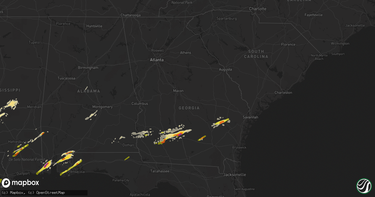
Hail Map in Georgia on January 21, 2017
Get this storm
January 21 map
$229
one time, instant access
Download today. No call, no setup
Keep the $229
Bought the map and want the full workflow? Apply the entire $229 to a subscription within 7 days. None of it is wasted.
Every map, not just this one
This buys you this map. Subscription and you get every map we run, in the markets you choose from a few cities to whole states to nationwide. Plus real-time alerts the moment a storm fires.
Contact data
Name, contact info, occupancy, even credit band for addresses in the footprint. You go from where it hit to who to call.
Become the source they trust
Unlimited branding weather history reports on demand. You already have the documented answer ready for the property owner, and you are the one who showed up with it.
Property data and RoofTrace estimates
Pull up any address you have got, its value and the exact code rules for that jurisdiction, straight from One Click Code. Then RoofTrace estimates the squares, pitch, and roof value, priced the way you price.
Storm reports in Georgia
Georgia
| Date | Description |
|---|---|
| 01/21/20172:51 PM CST | Mobile home damaged on moores chapel rd/sa attaway rd |
| 01/21/20172:34 PM CST | Warning point reported a portion of a commercial structure roof caved in near the intersection of weeping willow dr and veterans parkway. Time estimated based on radar. |
| 01/21/20172:30 PM CST | Clinch county emergency management reports that a shelter was blown down on 2 vehicles along leland smith road. |
| 01/21/20172:05 PM CST | Trees and powerlines down near jones street and tollison street. |
| 01/21/20171:58 PM CST | A nws survey team confirmed an ef-1 tornado in screven county. The tornado continued a northeast path along friendship road...damaging a firehouse...uprooting several l |
| 01/21/20171:55 PM CST | Social media videos show multiple non-residential structures destroyed and large hail...estimated at golf ball size in the community of cowford. Survey team is assessin |
| 01/21/20171:55 PM CST | Social media videos show multiple non-residential structures destroyed and large hail...estimated at golf ball size in the community of cowford. Survey team is assessin |
| 01/21/20171:53 PM CST | Twtter report shows a car flipped on its side...a roof blown off a house...metal siding removed from a fire station...and various other damage near the intersection of |
| 01/21/20171:52 PM CST | A nws survey team confirmed an ef-1 tornado in screven county. The tornado touched down in friendship memorial park and followed a northeast path. The tornado rolled a |
| 01/21/20171:50 PM CST | A national weather service survey team confirmed an ef-0 tornado in southern tattnall county. The tornado touched down just north of state route 178 near the rushing bo |
| 01/21/20171:48 PM CST | Trained spotter reported multiple trees... Road signs... And powerlines down with damage to chicken coops including metal roofs removed with portions left in trees near |
| 01/21/20171:44 PM CST | Screven county warning point reports multiple trees down and damage to a shed in the 5300 block of buttermilk rd. Possible tornado |
| 01/21/20171:44 PM CST | Powerline reported down on n zetterower ave at northside drive east. Time estimated based on radar. |
| 01/21/20171:42 PM CST | A nws survey team confirmed an ef-0 tornado in screven county. The tornado touched down along bay branch road and travelled north-northeast along a path about 3 minutes |
| 01/21/20171:40 PM CST | Two trees uprooted and two sheds destroyed on scrub oak rd. |
| 01/21/20171:40 PM CST | Trees and powerlines reported down on morris landing road. Possible tornado touchdown. |
| 01/21/20171:40 PM CST | Trees and powerlines reported down in northeast part of county near highway 144 and hendricks road. Possible tornado touchdown. |
| 01/21/20171:40 PM CST | Two trees uprooted and two sheds destroyed on scrub oak rd. |
| 01/21/20171:29 PM CST | A tree was blown down on highway 1 near todds fish farm. |
| 01/21/20171:26 PM CST | Warning point reported a tree down on highway 121 north near the land fill. Time estimated based on radar. |
| 01/21/20171:23 PM CST | An ef0 tornado touched near reeves road. The storm tracked northeast 1.5 miles with a width of 100 yards before dissipating near rosier road. The tornado damaged a meta |
| 01/21/20171:15 PM CST | Clear path of trees fallen near ga hwy 78 and immediately east of ga 17 |
| 01/21/20171:15 PM CST | Tree down on st. Paul church rd. |
| 01/21/20171:13 PM CST | Public reported trees and power lines down across highway 17 nw of midville ga. Wind damage extends north of highway 17 as well. Irrigation system flipped and destroyed |
| 01/21/20171:10 PM CST | Numerous trees down along canoochee bypass near lane rountree road. Also reports of small metal building destroyed in this area. Time estimated from radar. Possible tor |
| 01/21/20171:09 PM CST | An ef0 tornado touched down near old wadley road and highway 17. The storm tracked north-northeast 1.3 miles with width of 250 yards before dissipating near bark camp c |
| 01/21/20171:01 PM CST | Numerous trees and powerlines down between downtown swainsboro and industrial way... Where a large tree fell on powerlines near a substation and knocked power out. |
| 01/21/20171:00 PM CST | Mobile home damaged on moores chapel rd/sa attaway rd |
| 01/21/201712:49 PM CST | Numerous trees snapped and powerlines down. One tree fell and destroyed a home on the west side of sparta. Possible tornado |
| 01/21/201712:44 PM CST | Emergency manager reported at least 3 trees downed with no damages to structures. |
| 01/21/201712:43 PM CST | Possible tornadic damage. Multiple trees fallen on homes and powerlines. One mobile home split in two by an uprooted tree. No injuries. Just south of tennille at the in |
| 01/21/201712:42 PM CST | Ema reported damage to barn along triutt poole road and a cabin damaged along sa attaway road. Time estimated from radar. Tds signature from radar at this location. |
| 01/21/201712:42 PM CST | Mobile home damaged on moores chapel rd/sa attaway rd |
| 01/21/201712:40 PM CST | Mobile home damaged on moores chapel rd/sa attaway rd |
| 01/21/201712:40 PM CST | Reports of tress and power lines down along hwy 15 between mm 8-10 |
| 01/21/201712:40 PM CST | Ema reported damage to barn along triutt poole road and a cabin damaged along sa attaway road. Time estimated from radar. Tds signature from radar at this location. |
| 01/21/201712:30 PM CST | Numerous trees and powerlines down along deepstep road... Close to the hancock county line. |
| 01/21/201712:30 PM CST | Multiple trees and powerlines down along deep step rd. |
| 01/21/201712:30 PM CST | Multiple trees down and an irrigation system toppled |
| 01/21/201712:19 PM CST | Numerous trees were blown down in southern wilkinson county...primarily in the toomsboro area. |
| 01/21/201712:19 PM CST | Member of the public reported high winds to 60 mph. The winds were high enough to rock the mobile home they were in. There were no injuries. |
| 01/21/201712:18 PM CST | One tree down along owensboro road... Southwest of abbeville. |
| 01/21/201712:17 PM CST | One tree down along wilson road. Time estimated from radar. |
| 01/21/201712:15 PM CST | Tree down on hwy 112 at the worth county line. |
| 01/21/201712:09 PM CST | 2 trees down in the rochelle community. Time estimated from radar. |
| 01/21/201712:08 PM CST | Multiple trees down and a small tramboline tangled in power lines in ashburn ga. |
| 01/21/201712:08 PM CST | Trees were blown down onto highway 96. |
| 01/21/201712:02 PM CST | Tree down on hwy 33 south of hwy 32. |
| 01/21/201712:02 PM CST | Tree down near gaines ave |
| 01/21/201712:01 PM CST | Numerous trees downed across the county. Concentrated areas just west of dudley north and south of interstate 16. Damage correlates with radar signatures. |
| 01/21/201712:00 PM CST | Tree down on hwy 112 at the worth county line. |
| 01/21/201712:00 PM CST | Several trees down near porters corner rd. |
| 01/21/201711:57 AM CST | Multiple trees were reported down across the area as well as many powerlines. 911 center went down at the time. At the location of this lsr there was minor structural d |
| 01/21/201711:55 AM CST | A building on eastman highway received roof damage. |
| 01/21/201711:54 AM CST | A large tree was blown down on rawls street. |
| 01/21/201711:50 AM CST | Several trees down near porters corner rd. |
| 01/21/201711:50 AM CST | Power lines down around baconton |
| 01/21/201711:50 AM CST | Numerous trees down just south and west of danville |
| 01/21/201711:48 AM CST | Numerous reports of trees down from marion northeast toward jeffersonville |
| 01/21/201711:47 AM CST | Traffic lights and power lines down near venona. 46 mph winds. |
| 01/21/201711:40 AM CST | Stop sign blown over and tree fell on top of 2 cars on gleneagles dr |
| 01/21/201711:35 AM CST | Tree down at 3rd ave and dawson rd. |
| 01/21/201711:35 AM CST | Trees down blocking spring flats rd west of county line rd. |
| 01/21/201711:35 AM CST | Trees down blocking 400 block of mud creek rd. |
| 01/21/201711:32 AM CST | 3 homes sustained major damage...4 homes with minor damage in the hidden creek estates off of booth road. Numerous other trees and powerlines downed in the area. |
| 01/21/201711:31 AM CST | Rain wrapped tornado visually seen by amatuer radio moving north at 35 to 40 mph. |
| 01/21/201711:28 AM CST | Tree on a house near lake joy and sandefur road. Walmart at booth road in warner robins has roof damage. Spotter reports possible minor damage at kroger across the stre |
| 01/21/201711:25 AM CST | Fallen trees or limbs resulted in power outages |
| 01/21/201711:25 AM CST | Fallen trees and limbs resulted in power outages |
| 01/21/201711:22 AM CST | Rain wrapped tornado cross hwy 96 1/4 mile west of moody and hwy 96 intersection. Spotters vechicle hit by 8 inch tree limb as the tornado crossed the hwy. |
| 01/21/201711:22 AM CST | Tornadic damage appears to end southwest of juliette. Many trees down in the area and power lines down along the track ending near ga87. |
| 01/21/201711:15 AM CST | Fallen or leaning trees and limbs resulted in power outages |
| 01/21/201711:15 AM CST | Fallen or leaning trees and limbs resulted in power outages |
| 01/21/201711:07 AM CST | Multpile trees reported down in this part of the macon. |
| 01/21/201711:05 AM CST | Roof damage near salters veterinary hospital via twitter. |
| 01/21/201711:05 AM CST | Tornadic damage was located in smarr. Multpile trees down and also snapped. |
| 01/21/201711:00 AM CST | Residence on lake sinclair with 8 large pines uprooted and 4 other trees snapped. |
| 01/21/201710:44 AM CST | Damage reported southwest of the upson county airport. Many trees down and snapped... Trees on homes... Powerlines down. |
| 01/21/201710:30 AM CST | Residents report heavy roof damage to 2 homes with trees also down. Expected tornadic damage. |
| 01/21/201710:25 AM CST | Report indicates severe roof damage . |
| 01/21/201710:23 AM CST | In the western portion of the county there are many trees down near sunnsyside and pickard roads. Some of the trees were large. |
| 01/21/201710:21 AM CST | Damage reported at the riverbend restaurant on the flint river. Dozens of trees down... Snapped... And powerlines down. |
| 01/21/201710:17 AM CST | Multiple trees down near ll revell rd... Cove rd... And shirey rd. |
| 01/21/201710:17 AM CST | Numerous trees and powerlines down. Significant damage to a home. Residents home and no injuries. |
| 01/21/201710:15 AM CST | Residents report heavy roof damage to 2 homes with trees also down. Possible tornadic damage. |
| 01/21/20179:57 AM CST | Debris on road and power lines down on 27 northbound at chambliss road. And at hwy 315 intersection to holland road. Roads closed due to debris and powerlines down. |
| 01/21/20179:41 AM CST | 9 trees down in the town of cataula. One tree was hit by a car and another was on a house. |
| 01/21/20179:41 AM CST | 9 trees down in the town of cataula. One tree was hit by a car and another was on a house. Numerous trees downed in the area off chambliss road. No major damage to home |
| 01/21/20179:20 AM CST | Numerous trees down in laurel hills towards cgs airport |
| 01/21/20178:20 AM CST | Trees reported down in the northbound lane of i85 just south of exit 13. |
| 01/21/20177:45 AM CST | Emergency manager reports limbs and trees down southwest of lagrange. |
| 01/21/20175:58 AM CST | Chatham county em reports a tree down across the roadway near the intersection of bloomingdale rd and pine barron rd. Another large pine tree reported down on brampton |
| 01/21/20175:44 AM CST | The asos site klhw on wright army airfield at fort stewart measured a 56 knot wind gust with a passing line of thunderstorms. |
| 01/21/20175:15 AM CST | Power lines down |
| 01/21/20175:00 AM CST | Minor structural damage at appling county eoc. Time estimated with radar. |
| 01/21/20175:00 AM CST | Several downed trees near intersection of zoar rd and don hall rd. Time of event estimated with radar. Received via social media. |
| 01/21/20175:00 AM CST | Minor structural damage along golden isles parkway. Time of event estimated with radar. Rcvd via social media. |
| 01/21/20174:55 AM CST | Preliminary report- appling county em reported several buildings with signifcant damage north of baxley including the appling county eoc... An ems facility... Numerous |
| 01/21/20174:50 AM CST | Report received via social media of powerlines downed on us hwy 1 in baxley. |
| 01/21/20174:36 AM CST | Em reported one home with roof damage... And trees and powerlines downed in denton. Timing estimated by radar. |
| 01/21/20173:35 AM CST | Powerlines downed off of hickory lane in nicholls georgia. |
| 01/21/20173:28 AM CST | Trees down north henderson street in sylvester |
| 01/21/20173:25 AM CST | A national weather service survey team confirmed an ef-1 tornado in northern liberty county. The tornado crossed state route 119 north of willie...produced significant |
| 01/21/20172:58 AM CST | *** 2 fatal *** continuation of northeast brooks and cook county tornado into berrien county. This is the end point. Berrien county portion of the track rated ef3 due t |
| 01/21/20172:50 AM CST | *** 2 fatal *** damage along old lois road. Likely continuation of tornado from cook county. Fatalities confirmed by sherrif. Reported by walb-tv. |
| 01/21/20172:45 AM CST | Damage reported on caulie harris road with dual pol tds signature |
| 01/21/20172:45 AM CST | *** 7 fatal *** continuation of tornado from northeast brooks county. The cook county portion of the track is rated ef3 due to destruction in a mobile home park. |
| 01/21/20172:32 AM CST | *** 2 fatal *** damage reported in brooks county with dual-pol tds. Fatalities occurred when a house was displaced onto highway 122. |
| 01/21/20172:29 AM CST | *** 2 fatal *** second tornado touched down in northeast brooks county west of barney and moved through cook county and into berrien county. The northeast brooks county |
| 01/21/20172:18 AM CST | Continuation of thomas county tornado into northwest brooks county. This is the end point. The brooks county portion of this track is rated ef1 due to roof damage to a |
| 01/21/20171:58 AM CST | *** 3 inj *** damage reported in thomas county with dual-pol tds. 3 injuries reported |
| 01/21/20171:56 AM CST | Tornado touched down north of thomasville. Rated ef2 with a double wide mobile home destroyed. This tornado continued into northwest brooks county before lifting. |
| 01/21/20171:35 AM CST | Reports of trees down on houses in sylvester |
| 01/21/20171:17 AM CST | Reports of trees and power lines down |
| 01/21/201712:40 AM CST | Tree reported down in arlington |
| 01/21/201712:07 AM CST | A local report indicates 1.00 inch wind near ASHBURN |
| 01/20/201711:45 PM CST | 1 inch hail reported in albany |
| 01/20/201711:20 PM CST | Tree reported down in leary |
| 01/20/201711:00 PM CST | Picture of hail around quarter size from edison |
| 01/20/201711:00 PM CST | Tree reported down in edison |
| 01/20/201710:55 PM CST | Golf ball sized hail reported in waterloo |
| 01/20/201710:31 PM CST | Report of ping pong sized hail in poulan |
| 01/20/201710:15 PM CST | Quarter size hail on south county line road |
All States Impacted by Hail Map on January 21, 2017
Cities Impacted by Hail Map on January 21, 2017
- Magnolia, AR
- Omega, GA
- Forest, MS
- Lena, MS
- Marion, LA
- Haughton, LA
- Cotton Valley, LA
- Minden, LA
- Haynesville, LA
- Sarepta, LA
- Shongaloo, LA
- Theodore, AL
- Grand Bay, AL
- Mobile, AL
- Union, MS
- Walnut Grove, MS
- Monterey, LA
- Hayneville, AL
- Edison, GA
- Bluffton, GA
- Jena, LA
- Hattiesburg, MS
- Vicksburg, MS
- Century, FL
- Bay Minette, AL
- McDavid, FL
- Princeton, LA
- Marshall, TX
- Waskom, TX
- Ferriday, LA
- Jonesville, LA
- Sicily Island, LA
- Pearcy, AR
- Royal, AR
- Hot Springs National Park, AR
- Reidsville, GA
- Surrency, GA
- Glennville, GA
- Baxley, GA
- Natchitoches, LA
- Brandon, MS
- Wesson, MS
- Lucedale, MS
- El Dorado, AR
- Florence, MS
- Stapleton, AL
- Elberta, AL
- Seminole, AL
- Cantonment, FL
- Milton, FL
- Pensacola, FL
- Vivian, LA
- Daphne, AL
- Rebecca, GA
- Albany, GA
- Doerun, GA
- Poulan, GA
- Tifton, GA
- Baconton, GA
- Sumner, GA
- Ashburn, GA
- Sycamore, GA
- Fitzgerald, GA
- Chula, GA
- Ty Ty, GA
- Sylvester, GA
- Ocilla, GA
- Vaughan, MS
- Bastrop, LA
- Natchez, MS
- Zachary, LA
- Fayette, MS
- Union Church, MS
- Lockesburg, AR
- Dierks, AR
- De Queen, AR
- Morgan, GA
- Ludowici, GA
- Leary, GA
- Bivins, TX
- Jefferson, TX
- Trout, LA
- Simms, TX
- De Kalb, TX
- New Boston, TX
- Fort Rucker, AL
- Ozark, AL
- Midland City, AL
- New Brockton, AL
- Enterprise, AL
- Farmerville, LA
- Letohatchee, AL
- Robertsdale, AL
- Mer Rouge, LA
- Benton, LA
- Plain Dealing, LA
- Mooringsport, LA
- Hazlehurst, MS
- Mendenhall, MS
- Magee, MS
- Charleston, MS
- Tutwiler, MS
- Foley, AL
- Brooklyn, MS
- Wiggins, MS
- Lumberton, MS
- Canton, MS
- Stamps, AR
- Harrisonburg, LA
- New Augusta, MS
- Beaumont, MS
- Pearson, GA
- Millry, AL
- Conehatta, MS
- Morton, MS
- Braxton, MS
- Strong, AR
- Huttig, AR
- Emerson, AR
- Maplesville, AL
- Lyons, GA
- Pollock, LA
- Georgetown, LA
- Karnack, TX
- Semmes, AL
- State Line, MS
- Buckatunna, MS
- Richton, MS
- Abbeville, AL
- Shorterville, AL
- Pinola, MS
- Springhill, LA
- Taylor, AR
- Dubach, LA
- Starks, LA
- Ridgeland, MS
- Loxley, AL
- Hope Hull, AL
- Atmore, AL
- Irvington, AL
- Bernice, LA
- Clayton, LA
- Roxie, MS
- Georgetown, MS
- Homer, LA
- Summerfield, LA
- Lisbon, LA
- Spearsville, LA
- Lillie, LA
- Flowood, MS
- Pelahatchie, MS
- Newton, GA
- Lake, MS
- Waynesboro, MS
- Gilliam, LA
- Belcher, LA
- Ida, LA
- Hosston, LA
- Oil City, LA
- Utica, MS
- Raleigh, MS
- Daleville, AL
- Moss Point, MS
- Jackson, MS
- Edwards, MS
- Randolph, AL
- Jemison, AL
- Eight Mile, AL
- Lewisville, AR
- Coleman, GA
- Cuthbert, GA
- Arcadia, LA
- Dry Prong, LA
- Colfax, LA
- Newville, AL
- Rodessa, LA
- Lorman, MS
- Glenwood, AR
- Montgomery, LA
- Atlanta, LA
- Madison, MS
- Douglas, GA
- Nicholls, GA
- Foreman, AR
- Shellman, GA
- Dawson, GA
- Bronwood, GA
- Leesburg, GA
- Minter, AL
- Pine Apple, AL
- Bradley, AR
- Cloutierville, LA
- Poplarville, MS
- Fort Deposit, AL
- Molino, FL
- Flomaton, AL
- Perdido, AL
- Petal, MS
- Purvis, MS
- Athens, LA
- Oakfield, GA
- Warwick, GA
- Junction City, AR
- Camilla, GA
- Arlington, GA
- Fort Gaines, GA
- Blakely, GA
- Harrisville, MS
- Rochelle, GA
- Columbia, AL
- Pattison, MS
- Odum, GA
- Port Gibson, MS
- Willacoochee, GA
- Winnfield, LA
- Lena, LA
- Pineville, LA
- Deville, LA
- Vidalia, LA
- Hampton, AR
- New Orleans, LA
- Slaughter, LA
- Bon Secour, AL
- Pascagoula, MS
- Graceville, FL
- Marianna, FL
- Campbellton, FL
- Cottondale, FL
- Chipley, FL
- Amity, AR


