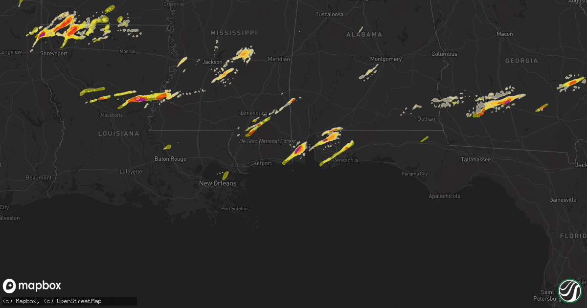
Hail Map on January 21, 2017
Get this storm
January 21 map
$229
one time, instant access
Download today. No call, no setup
Keep the $229
Bought the map and want the full workflow? Apply the entire $229 to a subscription within 7 days. None of it is wasted.
Every map, not just this one
This buys you this map. Subscription and you get every map we run, in the markets you choose from a few cities to whole states to nationwide. Plus real-time alerts the moment a storm fires.
Contact data
Name, contact info, occupancy, even credit band for addresses in the footprint. You go from where it hit to who to call.
Become the source they trust
Unlimited branding weather history reports on demand. You already have the documented answer ready for the property owner, and you are the one who showed up with it.
Property data and RoofTrace estimates
Pull up any address you have got, its value and the exact code rules for that jurisdiction, straight from One Click Code. Then RoofTrace estimates the squares, pitch, and roof value, priced the way you price.
States Impacted by Hail Map on January 21, 2017
Storm reports
Georgia
| Date | Description |
|---|---|
| 01/21/20172:51 PM CST | Mobile home damaged on moores chapel rd/sa attaway rd |
| 01/21/20172:34 PM CST | Warning point reported a portion of a commercial structure roof caved in near the intersection of weeping willow dr and veterans parkway. Time estimated based on radar. |
| 01/21/20172:30 PM CST | Clinch county emergency management reports that a shelter was blown down on 2 vehicles along leland smith road. |
| 01/21/20172:05 PM CST | Trees and powerlines down near jones street and tollison street. |
| 01/21/20171:58 PM CST | A nws survey team confirmed an ef-1 tornado in screven county. The tornado continued a northeast path along friendship road...damaging a firehouse...uprooting several l |
| 01/21/20171:55 PM CST | Social media videos show multiple non-residential structures destroyed and large hail...estimated at golf ball size in the community of cowford. Survey team is assessin |
| 01/21/20171:55 PM CST | Social media videos show multiple non-residential structures destroyed and large hail...estimated at golf ball size in the community of cowford. Survey team is assessin |
| 01/21/20171:53 PM CST | Twtter report shows a car flipped on its side...a roof blown off a house...metal siding removed from a fire station...and various other damage near the intersection of |
| 01/21/20171:52 PM CST | A nws survey team confirmed an ef-1 tornado in screven county. The tornado touched down in friendship memorial park and followed a northeast path. The tornado rolled a |
| 01/21/20171:50 PM CST | A national weather service survey team confirmed an ef-0 tornado in southern tattnall county. The tornado touched down just north of state route 178 near the rushing bo |
| 01/21/20171:48 PM CST | Trained spotter reported multiple trees... Road signs... And powerlines down with damage to chicken coops including metal roofs removed with portions left in trees near |
| 01/21/20171:44 PM CST | Screven county warning point reports multiple trees down and damage to a shed in the 5300 block of buttermilk rd. Possible tornado |
| 01/21/20171:44 PM CST | Powerline reported down on n zetterower ave at northside drive east. Time estimated based on radar. |
| 01/21/20171:42 PM CST | A nws survey team confirmed an ef-0 tornado in screven county. The tornado touched down along bay branch road and travelled north-northeast along a path about 3 minutes |
| 01/21/20171:40 PM CST | Two trees uprooted and two sheds destroyed on scrub oak rd. |
| 01/21/20171:40 PM CST | Trees and powerlines reported down on morris landing road. Possible tornado touchdown. |
| 01/21/20171:40 PM CST | Trees and powerlines reported down in northeast part of county near highway 144 and hendricks road. Possible tornado touchdown. |
| 01/21/20171:40 PM CST | Two trees uprooted and two sheds destroyed on scrub oak rd. |
| 01/21/20171:29 PM CST | A tree was blown down on highway 1 near todds fish farm. |
| 01/21/20171:26 PM CST | Warning point reported a tree down on highway 121 north near the land fill. Time estimated based on radar. |
| 01/21/20171:23 PM CST | An ef0 tornado touched near reeves road. The storm tracked northeast 1.5 miles with a width of 100 yards before dissipating near rosier road. The tornado damaged a meta |
| 01/21/20171:15 PM CST | Tree down on st. Paul church rd. |
| 01/21/20171:15 PM CST | Clear path of trees fallen near ga hwy 78 and immediately east of ga 17 |
| 01/21/20171:13 PM CST | Public reported trees and power lines down across highway 17 nw of midville ga. Wind damage extends north of highway 17 as well. Irrigation system flipped and destroyed |
| 01/21/20171:10 PM CST | Numerous trees down along canoochee bypass near lane rountree road. Also reports of small metal building destroyed in this area. Time estimated from radar. Possible tor |
| 01/21/20171:09 PM CST | An ef0 tornado touched down near old wadley road and highway 17. The storm tracked north-northeast 1.3 miles with width of 250 yards before dissipating near bark camp c |
| 01/21/20171:01 PM CST | Numerous trees and powerlines down between downtown swainsboro and industrial way... Where a large tree fell on powerlines near a substation and knocked power out. |
| 01/21/20171:00 PM CST | Mobile home damaged on moores chapel rd/sa attaway rd |
| 01/21/201712:49 PM CST | Numerous trees snapped and powerlines down. One tree fell and destroyed a home on the west side of sparta. Possible tornado |
| 01/21/201712:44 PM CST | Emergency manager reported at least 3 trees downed with no damages to structures. |
| 01/21/201712:43 PM CST | Possible tornadic damage. Multiple trees fallen on homes and powerlines. One mobile home split in two by an uprooted tree. No injuries. Just south of tennille at the in |
| 01/21/201712:42 PM CST | Mobile home damaged on moores chapel rd/sa attaway rd |
| 01/21/201712:42 PM CST | Ema reported damage to barn along triutt poole road and a cabin damaged along sa attaway road. Time estimated from radar. Tds signature from radar at this location. |
| 01/21/201712:40 PM CST | Ema reported damage to barn along triutt poole road and a cabin damaged along sa attaway road. Time estimated from radar. Tds signature from radar at this location. |
| 01/21/201712:40 PM CST | Mobile home damaged on moores chapel rd/sa attaway rd |
| 01/21/201712:40 PM CST | Reports of tress and power lines down along hwy 15 between mm 8-10 |
| 01/21/201712:30 PM CST | Numerous trees and powerlines down along deepstep road... Close to the hancock county line. |
| 01/21/201712:30 PM CST | Multiple trees and powerlines down along deep step rd. |
| 01/21/201712:30 PM CST | Multiple trees down and an irrigation system toppled |
| 01/21/201712:19 PM CST | Member of the public reported high winds to 60 mph. The winds were high enough to rock the mobile home they were in. There were no injuries. |
| 01/21/201712:19 PM CST | Numerous trees were blown down in southern wilkinson county...primarily in the toomsboro area. |
| 01/21/201712:18 PM CST | One tree down along owensboro road... Southwest of abbeville. |
| 01/21/201712:17 PM CST | One tree down along wilson road. Time estimated from radar. |
| 01/21/201712:15 PM CST | Tree down on hwy 112 at the worth county line. |
| 01/21/201712:09 PM CST | 2 trees down in the rochelle community. Time estimated from radar. |
| 01/21/201712:08 PM CST | Multiple trees down and a small tramboline tangled in power lines in ashburn ga. |
| 01/21/201712:08 PM CST | Trees were blown down onto highway 96. |
| 01/21/201712:02 PM CST | Tree down on hwy 33 south of hwy 32. |
| 01/21/201712:02 PM CST | Tree down near gaines ave |
| 01/21/201712:01 PM CST | Numerous trees downed across the county. Concentrated areas just west of dudley north and south of interstate 16. Damage correlates with radar signatures. |
| 01/21/201712:00 PM CST | Several trees down near porters corner rd. |
| 01/21/201712:00 PM CST | Tree down on hwy 112 at the worth county line. |
| 01/21/201711:57 AM CST | Multiple trees were reported down across the area as well as many powerlines. 911 center went down at the time. At the location of this lsr there was minor structural d |
| 01/21/201711:55 AM CST | A building on eastman highway received roof damage. |
| 01/21/201711:54 AM CST | A large tree was blown down on rawls street. |
| 01/21/201711:50 AM CST | Power lines down around baconton |
| 01/21/201711:50 AM CST | Several trees down near porters corner rd. |
| 01/21/201711:50 AM CST | Numerous trees down just south and west of danville |
| 01/21/201711:48 AM CST | Numerous reports of trees down from marion northeast toward jeffersonville |
| 01/21/201711:47 AM CST | Traffic lights and power lines down near venona. 46 mph winds. |
| 01/21/201711:40 AM CST | Stop sign blown over and tree fell on top of 2 cars on gleneagles dr |
| 01/21/201711:35 AM CST | Tree down at 3rd ave and dawson rd. |
| 01/21/201711:35 AM CST | Trees down blocking spring flats rd west of county line rd. |
| 01/21/201711:35 AM CST | Trees down blocking 400 block of mud creek rd. |
| 01/21/201711:32 AM CST | 3 homes sustained major damage...4 homes with minor damage in the hidden creek estates off of booth road. Numerous other trees and powerlines downed in the area. |
| 01/21/201711:31 AM CST | Rain wrapped tornado visually seen by amatuer radio moving north at 35 to 40 mph. |
| 01/21/201711:28 AM CST | Tree on a house near lake joy and sandefur road. Walmart at booth road in warner robins has roof damage. Spotter reports possible minor damage at kroger across the stre |
| 01/21/201711:25 AM CST | Fallen trees and limbs resulted in power outages |
| 01/21/201711:25 AM CST | Fallen trees or limbs resulted in power outages |
| 01/21/201711:22 AM CST | Rain wrapped tornado cross hwy 96 1/4 mile west of moody and hwy 96 intersection. Spotters vechicle hit by 8 inch tree limb as the tornado crossed the hwy. |
| 01/21/201711:22 AM CST | Tornadic damage appears to end southwest of juliette. Many trees down in the area and power lines down along the track ending near ga87. |
| 01/21/201711:15 AM CST | Fallen or leaning trees and limbs resulted in power outages |
| 01/21/201711:15 AM CST | Fallen or leaning trees and limbs resulted in power outages |
| 01/21/201711:07 AM CST | Multpile trees reported down in this part of the macon. |
| 01/21/201711:05 AM CST | Roof damage near salters veterinary hospital via twitter. |
| 01/21/201711:05 AM CST | Tornadic damage was located in smarr. Multpile trees down and also snapped. |
| 01/21/201711:00 AM CST | Residence on lake sinclair with 8 large pines uprooted and 4 other trees snapped. |
| 01/21/201710:44 AM CST | Damage reported southwest of the upson county airport. Many trees down and snapped... Trees on homes... Powerlines down. |
| 01/21/201710:30 AM CST | Residents report heavy roof damage to 2 homes with trees also down. Expected tornadic damage. |
| 01/21/201710:25 AM CST | Report indicates severe roof damage . |
| 01/21/201710:23 AM CST | In the western portion of the county there are many trees down near sunnsyside and pickard roads. Some of the trees were large. |
| 01/21/201710:21 AM CST | Damage reported at the riverbend restaurant on the flint river. Dozens of trees down... Snapped... And powerlines down. |
| 01/21/201710:17 AM CST | Multiple trees down near ll revell rd... Cove rd... And shirey rd. |
| 01/21/201710:17 AM CST | Numerous trees and powerlines down. Significant damage to a home. Residents home and no injuries. |
| 01/21/201710:15 AM CST | Residents report heavy roof damage to 2 homes with trees also down. Possible tornadic damage. |
| 01/21/20179:57 AM CST | Debris on road and power lines down on 27 northbound at chambliss road. And at hwy 315 intersection to holland road. Roads closed due to debris and powerlines down. |
| 01/21/20179:41 AM CST | 9 trees down in the town of cataula. One tree was hit by a car and another was on a house. Numerous trees downed in the area off chambliss road. No major damage to home |
| 01/21/20179:41 AM CST | 9 trees down in the town of cataula. One tree was hit by a car and another was on a house. |
| 01/21/20179:20 AM CST | Numerous trees down in laurel hills towards cgs airport |
| 01/21/20178:20 AM CST | Trees reported down in the northbound lane of i85 just south of exit 13. |
| 01/21/20177:45 AM CST | Emergency manager reports limbs and trees down southwest of lagrange. |
| 01/21/20175:58 AM CST | Chatham county em reports a tree down across the roadway near the intersection of bloomingdale rd and pine barron rd. Another large pine tree reported down on brampton |
| 01/21/20175:44 AM CST | The asos site klhw on wright army airfield at fort stewart measured a 56 knot wind gust with a passing line of thunderstorms. |
| 01/21/20175:15 AM CST | Power lines down |
| 01/21/20175:00 AM CST | Minor structural damage at appling county eoc. Time estimated with radar. |
| 01/21/20175:00 AM CST | Several downed trees near intersection of zoar rd and don hall rd. Time of event estimated with radar. Received via social media. |
| 01/21/20175:00 AM CST | Minor structural damage along golden isles parkway. Time of event estimated with radar. Rcvd via social media. |
| 01/21/20174:55 AM CST | Preliminary report- appling county em reported several buildings with signifcant damage north of baxley including the appling county eoc... An ems facility... Numerous |
| 01/21/20174:50 AM CST | Report received via social media of powerlines downed on us hwy 1 in baxley. |
| 01/21/20174:36 AM CST | Em reported one home with roof damage... And trees and powerlines downed in denton. Timing estimated by radar. |
| 01/21/20173:35 AM CST | Powerlines downed off of hickory lane in nicholls georgia. |
| 01/21/20173:28 AM CST | Trees down north henderson street in sylvester |
| 01/21/20173:25 AM CST | A national weather service survey team confirmed an ef-1 tornado in northern liberty county. The tornado crossed state route 119 north of willie...produced significant |
| 01/21/20172:58 AM CST | *** 2 fatal *** continuation of northeast brooks and cook county tornado into berrien county. This is the end point. Berrien county portion of the track rated ef3 due t |
| 01/21/20172:50 AM CST | *** 2 fatal *** damage along old lois road. Likely continuation of tornado from cook county. Fatalities confirmed by sherrif. Reported by walb-tv. |
| 01/21/20172:45 AM CST | *** 7 fatal *** continuation of tornado from northeast brooks county. The cook county portion of the track is rated ef3 due to destruction in a mobile home park. |
| 01/21/20172:45 AM CST | Damage reported on caulie harris road with dual pol tds signature |
| 01/21/20172:32 AM CST | *** 2 fatal *** damage reported in brooks county with dual-pol tds. Fatalities occurred when a house was displaced onto highway 122. |
| 01/21/20172:29 AM CST | *** 2 fatal *** second tornado touched down in northeast brooks county west of barney and moved through cook county and into berrien county. The northeast brooks county |
| 01/21/20172:18 AM CST | Continuation of thomas county tornado into northwest brooks county. This is the end point. The brooks county portion of this track is rated ef1 due to roof damage to a |
| 01/21/20171:58 AM CST | *** 3 inj *** damage reported in thomas county with dual-pol tds. 3 injuries reported |
| 01/21/20171:56 AM CST | Tornado touched down north of thomasville. Rated ef2 with a double wide mobile home destroyed. This tornado continued into northwest brooks county before lifting. |
| 01/21/20171:35 AM CST | Reports of trees down on houses in sylvester |
| 01/21/20171:17 AM CST | Reports of trees and power lines down |
| 01/21/201712:40 AM CST | Tree reported down in arlington |
| 01/21/201712:07 AM CST | A local report indicates 1.00 inch wind near ASHBURN |
| 01/20/201711:45 PM CST | 1 inch hail reported in albany |
| 01/20/201711:20 PM CST | Tree reported down in leary |
| 01/20/201711:00 PM CST | Tree reported down in edison |
| 01/20/201711:00 PM CST | Picture of hail around quarter size from edison |
| 01/20/201710:55 PM CST | Golf ball sized hail reported in waterloo |
| 01/20/201710:31 PM CST | Report of ping pong sized hail in poulan |
| 01/20/201710:15 PM CST | Quarter size hail on south county line road |
Alabama
| Date | Description |
|---|---|
| 01/21/201710:44 AM CST | Trees down throughout randolph county. |
| 01/21/201710:40 AM CST | Downed power pole near the corner of hwy 55 and hwy 68 in loxley |
| 01/21/201710:05 AM CST | Widespread reports of trees and powerlines down across lee county. . |
| 01/21/201710:00 AM CST | Tree down on county rd 68. |
| 01/21/20179:52 AM CST | Tree fell on car on matthews ave. |
| 01/21/20179:42 AM CST | Large tree and tin roofing blocking county rd 278 at 4220. . |
| 01/21/20179:32 AM CST | Reports of trees down in louisville along county road 17. Possible tornado. Time estimated from radar. |
| 01/21/20179:30 AM CST | A tornado occurred in pike county and the damage continued into barbour county. The tornado moved eastward and ended just east of louisville. |
| 01/21/20179:23 AM CST | 4 trees down in the northern part of coffee county. |
| 01/21/20179:20 AM CST | A tornado affected areas just southwest of smith station. The tornado was rated an ef1 with winds estimated around 90 mph. The most significant damage occurred at the h |
| 01/21/20179:20 AM CST | A weak tornado damage path was found by emergency management starting just west of the banks feed mill on alabama hwy 93 and going east to county road 4405. Debris sign |
| 01/21/20179:18 AM CST | Damage to roof and athletic field at smiths station high school. Possible tornado. Time estimated by radar. |
| 01/21/20179:10 AM CST | Trees down across george wallace drive in troy. Possible tornado. Time estimated by radar. |
| 01/21/20179:08 AM CST | Ef0 tornado with winds of 80mph briefly touched down north of crawford in the haley woods subdivision causing minor damage to several roofs and wooden fences. Path leng |
| 01/21/20179:05 AM CST | Sheet metal scattered in yard and tree damage north of crawford. Possible tornado. Time estimated by radar. |
| 01/21/20179:00 AM CST | Ef0 tornado with 65 mph winds downed trees and caused shingle damage near state highway 169 in southern opelika. |
| 01/21/20178:56 AM CST | An ef-0 tornado touched down along lee road 413... Causing some shingle damage and uprooting several trees along its brief path toward the northeast... Ending along cr- |
| 01/21/20178:55 AM CST | Tree down on garage near the community of gantt |
| 01/21/20178:55 AM CST | An ef1 touched down in western pike county and traveled eastward. The damage went across pike county and may have been one than one tornado. Further assessment is neede |
| 01/21/20178:50 AM CST | Numerous trees and power lines down. 1 business experienced minor wind damage. |
| 01/21/20178:49 AM CST | Ef0 tornado with 70 mph winds downed trees near sand hill road. |
| 01/21/20178:48 AM CST | Numerous trees down on cr 43... Just on the macon side of the lee/macon county line. Possible tornado. |
| 01/21/20178:48 AM CST | A tornado produced tree and minor roof damage near the lee and macon county line. |
| 01/21/20178:45 AM CST | Widespread reports of trees and powerlines down across lee county. . |
| 01/21/20178:45 AM CST | Multiple trees down across tallapoosa county. Roads were blocked... But have been cleared. . |
| 01/21/20178:29 AM CST | Trees and powerlines down across willow springs rd. Possible tornado. . |
| 01/21/20178:25 AM CST | Trees down along evergreen avenue |
| 01/21/20178:22 AM CST | Trees down on a home on elizabeth street. Another home had slight damage from a fallen tree on garland road. |
| 01/21/20178:20 AM CST | Trees and powerlines down on washington st. In tuskegee. Time estimated by radar. |
| 01/21/20178:18 AM CST | Sheet metal shed blown down... Trees uprooted... And fence blown down in lyeffion... Al on hwy 83. |
| 01/21/20178:18 AM CST | Several trees fallen on homes and trees down between hwy 31 and sowell rd. |
| 01/21/20178:10 AM CST | Barn destroyed along with shingle damage to a home near the intersection of highway 83 and county road 22. Several trees downed. |
| 01/21/20178:05 AM CST | Sheet metal and tree damage north of crawford. This is a correction from previous lsr. Correct location is in lee county. Possible tornado. Time estimated by radar. |
| 01/21/20178:00 AM CST | Several cars shifted and moved into each other due to thunderstorm wind. |
| 01/21/20177:57 AM CST | Powerlines down in redland. Possible tornado. Time estimated by radar. |
| 01/21/20177:57 AM CST | Reported at 502 main street wetumpka... Al tree down on house. Time estimated by radar. Possible tornado. |
| 01/21/20177:57 AM CST | Ef0 briefly touched down near emerald mountain christian school with winds of 75mph... Causing minor damage to fencing and metal siding. Path length 0.59 mile. Path wid |
| 01/21/20177:55 AM CST | A tornado moved through wetumpka and produced tree and structure damage. |
| 01/21/20177:55 AM CST | An ef1 tornado with winds of 90 mph touched down briefly just south of willow springs rd and moved north northeast causing tree damage. Path length 0.68 mi. Path width |
| 01/21/20177:45 AM CST | Trees and powerlines down along hwy 14 in elmore. Possible tornado. Time estimated by radar. |
| 01/21/20177:20 AM CST | Tree snapped in safford... Al. Possible tornado. |
| 01/21/20177:15 AM CST | Large tree on a home on darling lane |
| 01/21/20176:45 AM CST | Large pine tree uprooted... Tree limbs snapped...and fence blown down near a public residence. |
| 01/21/20176:45 AM CST | Tree down across car in sardis... Al. Time estimated by radar. |
| 01/21/20176:04 AM CST | 18-wheeler blown over near benton on u.s. Highway 80. . |
| 01/21/20172:05 AM CST | Tree down in ashford |
| 01/21/20171:42 AM CST | Tree on home in susan moore. |
| 01/21/20171:38 AM CST | Trees down in oneonta. |
| 01/21/20171:38 AM CST | Winds of 70-80 mph caused a damage swath 1.4 miles long and 1000 yds wide in oneonta... Downing 200 trees and damaging or destroying over 60 structures. |
| 01/21/20171:30 AM CST | Tree down on home on 3rd street in hayden. |
| 01/21/20171:29 AM CST | Tree down on home in locust fork. |
| 01/21/20171:18 AM CST | Tree down on i-65 at mm 289. |
| 01/21/20171:14 AM CST | 65 kts gust at kbhm airport. |
| 01/21/20171:09 AM CST | Trees down near mcdonald st in tarrant. |
| 01/21/20171:08 AM CST | Trees down near rocky ridge. |
| 01/21/20171:08 AM CST | Trees down in vestavia hills... Including at us highway 31 and kentucky ave. |
| 01/21/20171:07 AM CST | Trees down in homewood. |
| 01/21/20171:07 AM CST | Tree down on queensview rd. |
| 01/21/20171:01 AM CST | Power lines down near 67th st and pineview rd. |
| 01/21/201712:57 AM CST | Trees and power lines down on 8th place in pleasant grove. |
| 01/21/201712:57 AM CST | Numerous trees down in bessemer. |
| 01/21/201712:50 AM CST | Trees down on buddy vines camp rd. |
| 01/21/201712:47 AM CST | Tree down on hwy 25... Northeast of centreville... At entrance to church drive. Additional trees were knocked down across the county. |
| 01/21/201712:36 AM CST | Brief ef0 with winds of 80mph touched down along hagler coaling rd... Downing a dozen trees. One tree damaged a home. Path length 0.3 mile. Max width 200yds. The durati |
| 01/21/201712:10 AM CST | Tree down along hwy 10 east |
| 01/20/201711:11 PM CST | A few trees down across northeastern portions of the county as well. |
| 01/20/201710:25 PM CST | Hail to the size of quarters was reported in jemison. Time estimated from radar. |
| 01/20/201710:24 PM CST | Quarter size hail reported on county road 57 |
| 01/20/201710:14 PM CST | Quarter sized hail reported in ozark |
| 01/20/20179:15 PM CST | Quarter size hail reported in copeland via social media |
| 01/20/20178:30 PM CST | Tree fell on commercial building in downtown brewton. Time estimated via radar |
| 01/20/20177:18 PM CST | Off duty nws employee reports one inch hail in elberta |
| 01/20/20176:55 PM CST | Off duty nws employee reports 2 inch hail off dawes rd |
Louisiana
| Date | Description |
|---|---|
| 01/21/20175:58 PM CST | Picture of a tornado with debris taken by public... Along cedar bend road. |
| 01/21/20175:58 PM CST | Second round of hail on conley road... Quarter size |
| 01/21/20175:56 PM CST | *** 1 inj *** an ef2 tornado touched down northeast of natchez uprooting and/or snapping numerous trees and downing powerlines. 5 homes suffered significant damage. Sev |
| 01/21/20175:55 PM CST | An ef-1 tornado with winds estimated between 100-105 mph touched down south of shongaloo along elmer moore road and continued northeast across rodney martin...wortham.. |
| 01/21/20175:55 PM CST | Roof is off of a home along patrick road. |
| 01/21/20175:55 PM CST | *** 1 inj *** two homes destroyed along patrick road and hwy 494. A man has a broken arm. |
| 01/21/20175:50 PM CST | 2 hail reported in serepta |
| 01/21/20175:50 PM CST | Photo of large hail via ksla facebook. |
| 01/21/20175:50 PM CST | Golf ball size hail reported in springhill. |
| 01/21/20175:50 PM CST | A local report indicates 1.00 inch wind near NATCHITOCHES |
| 01/21/20175:50 PM CST | . |
| 01/21/20175:38 PM CST | Multiple trees down on mott road... And structural damage to home. |
| 01/21/20175:35 PM CST | Trees down across hwy 2. . |
| 01/21/20175:30 PM CST | Hail conley road |
| 01/21/20175:15 PM CST | Heavy storm damage to several homes n the vicinity of mott rd...pleasant hill rd...and the shiloh area. Multiple reports of down power lines and trees down. No reports |
| 01/21/20175:15 PM CST | Power lines down. Mobile homes damaged... With people trapped east of plain dealing. |
| 01/21/20175:12 PM CST | *** 1 inj *** an ef2 tornado touched down east southeast of plain dealing louisiana. Structural damage consisted of mobile homes rolled and destroyed and severe damage |
| 01/21/20175:11 PM CST | A local report indicates 1.00 inch wind near 15 ENE NEW ORLEANS |
| 01/21/20175:10 PM CST | Quarter size hail in hosston at i49 and hwy 2. |
| 01/21/20175:09 PM CST | Bossier sheriffs are reporting golf ball size hail in plain dealing. |
| 01/21/20175:05 PM CST | Bossier sheriffs reporting damage in and around plain dealing... Including trees down as well as damage to homes and vehicles. |
| 01/21/20174:55 PM CST | Picture of 2 inch tweeted to the office. |
| 01/21/20174:55 PM CST | 2 inch hail tweeted from the public. |
| 01/21/20176:15 AM CST | Several homes with shingles blown off and fences down on furman drive. |
| 01/20/20179:55 PM CST | 5 utility poles blown over along hwy 165 between mer rouge and bonita |
| 01/20/20179:04 PM CST | This tornado began just west of us 165 north of mer rouge and tracked 9.25 miles northeastward to just southeast of bonita... Ending just east of horace hill rd. Three |
| 01/20/20178:49 PM CST | Power lines down in mer rouge. |
| 01/20/20178:48 PM CST | An ef0 tornado snapped a few small trees at the initial point of touchdown. The tornado moved east northeast and caused considerable damage to a metal shed and before l |
| 01/20/20178:30 PM CST | 2 businesses... Several homes... And 2 vehicles damaged along highway 8... Ending just before 3107. |
| 01/20/20178:29 PM CST | An ef1 tornado touched down snapping trees west of hwy 1304 near hwy 8. A wooden barn was damaged and a uprooted tree fell on a church. A gas station canopy was blown 5 |
| 01/20/20178:15 PM CST | Windshield busted in ambulance due to hail |
| 01/20/20177:51 PM CST | An ef1 tornado touched down south of georgetown downing and/or snapping numerous trees and powerlines. The tornado first touched down on hwy. 165 and moved east northea |
| 01/20/20177:50 PM CST | . |
| 01/20/20177:50 PM CST | Trees snapped and uprooted. |
| 01/20/20177:46 PM CST | Golf ball to baseball size hail reported in jonesville |
| 01/20/20177:45 PM CST | 3.5 inch hail estimated southwest of jonesville just off of hwy 84 |
| 01/20/20177:30 PM CST | 1 inch hail in spearsville. |
| 01/20/20177:28 PM CST | A local report indicates 1.25 inch wind near ARCHIE |
| 01/20/20177:25 PM CST | 1 inch hail in dry prong. |
| 01/20/20177:00 PM CST | Quarter size hail in white hall along hwy 8. |
| 01/20/20177:00 PM CST | *** 1 inj *** en ef1 tornado snapped and/or uprooted numerous trees and downed powerlines northwest of colfax. A single wide mobile home flipped over injuring a woman i |
| 01/20/20176:55 PM CST | A local report indicates 2.50 inch wind near SHONGALOO |
| 01/20/20176:52 PM CST | A local report indicates 1.75 inch wind near SHONGALOO |
| 01/20/20176:30 PM CST | Picture of large hail via ksla facebook. |
| 01/20/20176:20 PM CST | Picture of large hail via ktbs facebook. |
| 01/20/20176:15 PM CST | Public photo of hail at lake claiborne via ksla facebook. |
| 01/20/20176:07 PM CST | A local report indicates 1.00 inch wind near HOSSTON |
Arkansas
| Date | Description |
|---|---|
| 01/21/20175:55 PM CST | Golf ball size hail along hwy 160 east of taylor. |
| 01/21/20175:33 PM CST | Estimated hail size of 1 inch reported by public near highway 70 northeast of glenwood. |
| 01/20/20179:33 PM CST | Tree across hwy 159. |
| 01/20/20179:17 PM CST | Tree across hwy 159. |
| 01/20/20179:14 PM CST | Several trees down across town... One across the railroad track and some power lines down. |
| 01/20/20179:04 PM CST | Social media report of multiple powerlines blown down along highway 293. |
| 01/20/20178:55 PM CST | A few trees were blown down on florence road. |
| 01/20/20178:47 PM CST | Trees were blown down along highway 425. |
| 01/20/20178:45 PM CST | A few trees were blown down on old highway 13. |
| 01/20/20178:45 PM CST | Brief touchdown in a field just northwest of hamburg. Picture evidence from public/storm chaser. No damage noted during nws survey. Tracked about half a mile... 50 yard |
| 01/20/20178:40 PM CST | A few trees were blown down on old warren road. |
| 01/20/20178:35 PM CST | Trees down along highways 133 and 189. |
| 01/20/20178:25 PM CST | A local report indicates 1.00 inch wind near 4 ENE PEARCY |
| 01/20/20178:20 PM CST | Quarter size hail in huttig. It fell for several minutes. |
| 01/20/20178:10 PM CST | Trees were blown down in rural portions of the county...primarily west of warren. |
| 01/20/20177:38 PM CST | An ef0 tornado touched down east of el dorado arkansas...snapping a few small trees near the lawson community. The tornado hit a single wide mobile home...peeling back |
| 01/20/20177:35 PM CST | A house in lawson lost the roof and the side of the home caved in. |
| 01/20/20177:25 PM CST | Dime to quarter size hail in el dorado. |
| 01/20/20177:10 PM CST | A local report indicates 1.00 inch wind near 5 N DIERKS |
| 01/20/20177:04 PM CST | An ef1 tornado touched down southwest of el dordo... Arkansas. Damage consisted of several small snapped pines at initial touchdown but as the storm moved north northea |
| 01/20/20176:30 PM CST | Photo of large hail in the walker creek community. |
| 01/20/20176:05 PM CST | Photo of large hail near taylor arkansas via ktal todd warren facebook. |
Mississippi
| Date | Description |
|---|---|
| 01/20/201711:29 PM CST | Trees down along koa road |
| 01/20/201711:27 PM CST | Trees and power lines down along greenhill loop road |
| 01/20/201711:14 PM CST | Trees down along i-59 and county road 333 just west of enterprise |
| 01/20/201710:44 PM CST | *** 1 inj *** this ef-2 tornado touched down near russell topton rd and tracked 7.3 mi with a maximum width of 550 yds and maximum winds of 120 mph...and it lifted just |
| 01/20/201710:44 PM CST | Trees down along rabbit road |
| 01/20/201710:41 PM CST | Church was damaged on fred clayton rd. |
| 01/20/201710:41 PM CST | *** 1 inj *** 1 injury sustained in a mobile home due to damaging winds |
| 01/20/201710:38 PM CST | Trees down along sunshine road |
| 01/20/201710:17 PM CST | Multiple trees down along hwy 18 between raleigh and white oak |
| 01/20/20179:40 PM CST | Quarter size hail reported in beaumont with thunderstorm passage. Time estimated via radar |
| 01/20/20179:38 PM CST | Quarter size hail in wesson and beauregard |
| 01/20/20179:35 PM CST | Golf ball hail in the braxton area. |
| 01/20/20179:30 PM CST | Power lines down along hwy 21 north |
| 01/20/20179:20 PM CST | Golf ball hail near hwy 35 and old jackson road in the hillsboro community |
| 01/20/20179:15 PM CST | Quarter size hail in the morton area |
| 01/20/20179:15 PM CST | Quarter size hail in the mclaurin area |
| 01/20/20179:10 PM CST | Tree down across springfield road near the intersection of hwy 13s |
| 01/20/20178:55 PM CST | Nickel to quarter size hail between pelahatchie and the county line |
| 01/20/20178:53 PM CST | Hail to the size of quarters was falling south of lake caroline. |
| 01/20/20178:52 PM CST | Golf ball size hail estimated in the church hill area |
| 01/20/20178:51 PM CST | Tree reported down across kingston rd. |
| 01/20/20178:43 PM CST | A local report indicates 1.00 inch wind near 5 NNW BRANDON |
| 01/20/20178:29 PM CST | One inch hail reported near beaumont |
| 01/20/20178:24 PM CST | Hail to the size of quarters was falling near vicksburg. |
| 01/20/20178:23 PM CST | Hail up to the size of quarters was falling in the robinhood community. |
| 01/20/20178:20 PM CST | Near the vicksburg mall |
| 01/20/20177:54 PM CST | Quarter size hail on pistol ridge road...reported by hattiesburg eoc |
| 01/20/20176:40 PM CST | A local report indicates 1.00 inch wind near MOSS POINT |
Texas
| Date | Description |
|---|---|
| 01/21/20175:48 PM CST | Quarter size hail in new boston. |
| 01/21/20175:20 PM CST | Quarter size hail in the mcleod community. |
| 01/21/20174:50 PM CST | Video of large hail in the gray community via ksla facebook. |
| 01/21/20174:50 PM CST | An ef2 tornado touched down near smithville... Texas uprooting numerous trees and downing powerlines. Several vehicles were moved and a party barge was dumped 200 yards |
| 01/21/20174:22 PM CST | Video on twitter shows severe damage to a home along fm 1988 in scottsville. |
| 01/21/20174:20 PM CST | A local report indicates 1.00 inch wind near SCOTTSVILLE |
| 01/21/20174:19 PM CST | An ef1 tornado uprooted and/or snapped several trees along its path. Most of its damage was found on kellyville cutoff road where one home was damaged and the roof remo |
| 01/21/20174:18 PM CST | An ef2 tornado touched down near scottsville texas uprooting numerous trees and downing powerlines along its track. The tornado did its most destructive damage on trame |
Florida
| Date | Description |
|---|---|
| 01/21/201710:31 AM CST | Tree down on powerline on spring lake rd. |
| 01/21/20175:15 AM CST | Power lines down on fairbanks ferry road |
| 01/21/20175:13 AM CST | Multiple trees down on salem road |
| 01/21/20175:05 AM CST | Tree down on mcnair rd. |
| 01/21/20175:05 AM CST | Tree down on mcbride ct |
| 01/20/20178:06 PM CST | Reports of measured 2 inch hail near walnut hill. |
| 01/20/20177:49 PM CST | One to two inch hail reported near pace. Time estimated via radar |
South Carolina
| Date | Description |
|---|---|
| 01/21/20173:20 PM CST | Trees down at the intersection of us highway 301 and binnicker bridge rd. . |
| 01/21/20173:20 PM CST | Trees down at the intersection of us highway 301 and binnicker bridge rd. . |
| 01/21/20173:10 PM CST | Trees down at hwy 70 and hwy 332. Photos relayed via social media. |
| 01/21/20173:10 PM CST | Trees down at hwy 70 and hwy 332. Photos relayed via social media. |
| 01/21/20173:05 PM CST | Public report of trees down on us hwy 321 near orangeburg-bamberg co line. Photos relayed via social media. |
| 01/21/20173:05 PM CST | Public report of trees down on us hwy 321 near orangeburg-bamberg co line. Photos relayed via social media. |
| 01/21/20173:05 PM CST | Trees down on hwy 70 at orangeburg-bamberg co line. Photo relayed via social media. |
| 01/21/20173:05 PM CST | Trees down on hwy 70 at orangeburg-bamberg co line. Photo relayed via social media. |
| 01/21/20173:04 PM CST | Tree reported down at the intersection of paul street and wichman street. Time estimated based on radar. |
| 01/21/20173:02 PM CST | Numerous trees down on us hwy 78 west of denmark. Road impassable and traffic being detoured. |
| 01/21/20173:02 PM CST | Numerous trees down on us hwy 78 west of denmark. Road impassable and traffic being detoured. |
| 01/21/20173:00 PM CST | Public reported trees down and power poles snapped on gardenia rd near dally rd. Photos relayed via social media. . |
| 01/21/20173:00 PM CST | Public reported trees down and power poles snapped on gardenia rd near dally rd. Photos relayed via social media. . |
| 01/21/20172:52 PM CST | *** 1 inj *** mobile home destroyed at pleasant home rd and hwy 3. A female inside the mobile home was trapped... Rescued and transported to the hospital. Extent of inj |
| 01/21/20172:52 PM CST | *** 1 inj *** mobile home destroyed at pleasant home rd and hwy 3. A female inside the mobile home was trapped... Rescued and transported to the hospital. Extent of inj |
| 01/21/20172:52 PM CST | Numerous trees down in barnwell state park. 20-30 people are still trapped inside the park as of 6pm. |
| 01/21/20172:52 PM CST | Numerous trees down in barnwell state park. 20-30 people are still trapped inside the park as of 6pm. |
| 01/21/20172:49 PM CST | Tree reported down at the intersection of enoch road and hudson mill road. Time estimated based on radar. |
| 01/21/20172:31 PM CST | Tree reported down on grays hwy. Time estimated based on radar. |
| 01/21/20172:27 PM CST | Hampton county emergency management reported several trees down on john penn road near cypress creek road. There was also damage to an old home in this area. Possible t |
| 01/21/20172:20 PM CST | Hampton county emergency management reported several trees down along mckenzie trail near furman. |
| 01/21/20172:16 PM CST | Tree reported down on us-321 just south of scotia. Time is estimated based on radar. |
Cities Impacted by Hail Map on January 21, 2017
- Magnolia, AR
- Omega, GA
- Forest, MS
- Lena, MS
- Marion, LA
- Haughton, LA
- Cotton Valley, LA
- Minden, LA
- Haynesville, LA
- Sarepta, LA
- Shongaloo, LA
- Theodore, AL
- Grand Bay, AL
- Mobile, AL
- Union, MS
- Walnut Grove, MS
- Monterey, LA
- Hayneville, AL
- Edison, GA
- Bluffton, GA
- Jena, LA
- Hattiesburg, MS
- Vicksburg, MS
- Century, FL
- Bay Minette, AL
- McDavid, FL
- Princeton, LA
- Marshall, TX
- Waskom, TX
- Ferriday, LA
- Jonesville, LA
- Sicily Island, LA
- Pearcy, AR
- Royal, AR
- Hot Springs National Park, AR
- Reidsville, GA
- Surrency, GA
- Glennville, GA
- Baxley, GA
- Natchitoches, LA
- Brandon, MS
- Wesson, MS
- Lucedale, MS
- El Dorado, AR
- Florence, MS
- Stapleton, AL
- Elberta, AL
- Seminole, AL
- Cantonment, FL
- Milton, FL
- Pensacola, FL
- Vivian, LA
- Daphne, AL
- Rebecca, GA
- Albany, GA
- Doerun, GA
- Poulan, GA
- Tifton, GA
- Baconton, GA
- Sumner, GA
- Ashburn, GA
- Sycamore, GA
- Fitzgerald, GA
- Chula, GA
- Ty Ty, GA
- Sylvester, GA
- Ocilla, GA
- Vaughan, MS
- Bastrop, LA
- Natchez, MS
- Zachary, LA
- Fayette, MS
- Union Church, MS
- Lockesburg, AR
- Dierks, AR
- De Queen, AR
- Morgan, GA
- Ludowici, GA
- Leary, GA
- Bivins, TX
- Jefferson, TX
- Trout, LA
- Simms, TX
- De Kalb, TX
- New Boston, TX
- Fort Rucker, AL
- Ozark, AL
- Midland City, AL
- New Brockton, AL
- Enterprise, AL
- Farmerville, LA
- Letohatchee, AL
- Robertsdale, AL
- Mer Rouge, LA
- Benton, LA
- Plain Dealing, LA
- Mooringsport, LA
- Hazlehurst, MS
- Mendenhall, MS
- Magee, MS
- Charleston, MS
- Tutwiler, MS
- Foley, AL
- Brooklyn, MS
- Wiggins, MS
- Lumberton, MS
- Canton, MS
- Stamps, AR
- Harrisonburg, LA
- New Augusta, MS
- Beaumont, MS
- Pearson, GA
- Millry, AL
- Conehatta, MS
- Morton, MS
- Braxton, MS
- Strong, AR
- Huttig, AR
- Emerson, AR
- Maplesville, AL
- Lyons, GA
- Pollock, LA
- Georgetown, LA
- Karnack, TX
- Semmes, AL
- State Line, MS
- Buckatunna, MS
- Richton, MS
- Abbeville, AL
- Shorterville, AL
- Pinola, MS
- Springhill, LA
- Taylor, AR
- Dubach, LA
- Starks, LA
- Ridgeland, MS
- Loxley, AL
- Hope Hull, AL
- Atmore, AL
- Irvington, AL
- Bernice, LA
- Clayton, LA
- Roxie, MS
- Georgetown, MS
- Homer, LA
- Summerfield, LA
- Lisbon, LA
- Spearsville, LA
- Lillie, LA
- Flowood, MS
- Pelahatchie, MS
- Newton, GA
- Lake, MS
- Waynesboro, MS
- Gilliam, LA
- Belcher, LA
- Ida, LA
- Hosston, LA
- Oil City, LA
- Utica, MS
- Raleigh, MS
- Daleville, AL
- Moss Point, MS
- Jackson, MS
- Edwards, MS
- Randolph, AL
- Jemison, AL
- Eight Mile, AL
- Lewisville, AR
- Coleman, GA
- Cuthbert, GA
- Arcadia, LA
- Dry Prong, LA
- Colfax, LA
- Newville, AL
- Rodessa, LA
- Lorman, MS
- Glenwood, AR
- Montgomery, LA
- Atlanta, LA
- Madison, MS
- Douglas, GA
- Nicholls, GA
- Foreman, AR
- Shellman, GA
- Dawson, GA
- Bronwood, GA
- Leesburg, GA
- Minter, AL
- Pine Apple, AL
- Bradley, AR
- Cloutierville, LA
- Poplarville, MS
- Fort Deposit, AL
- Molino, FL
- Flomaton, AL
- Perdido, AL
- Petal, MS
- Purvis, MS
- Athens, LA
- Oakfield, GA
- Warwick, GA
- Junction City, AR
- Camilla, GA
- Arlington, GA
- Fort Gaines, GA
- Blakely, GA
- Harrisville, MS
- Rochelle, GA
- Columbia, AL
- Pattison, MS
- Odum, GA
- Port Gibson, MS
- Willacoochee, GA
- Winnfield, LA
- Lena, LA
- Pineville, LA
- Deville, LA
- Vidalia, LA
- Hampton, AR
- New Orleans, LA
- Slaughter, LA
- Bon Secour, AL
- Pascagoula, MS
- Graceville, FL
- Marianna, FL
- Campbellton, FL
- Cottondale, FL
- Chipley, FL
- Amity, AR