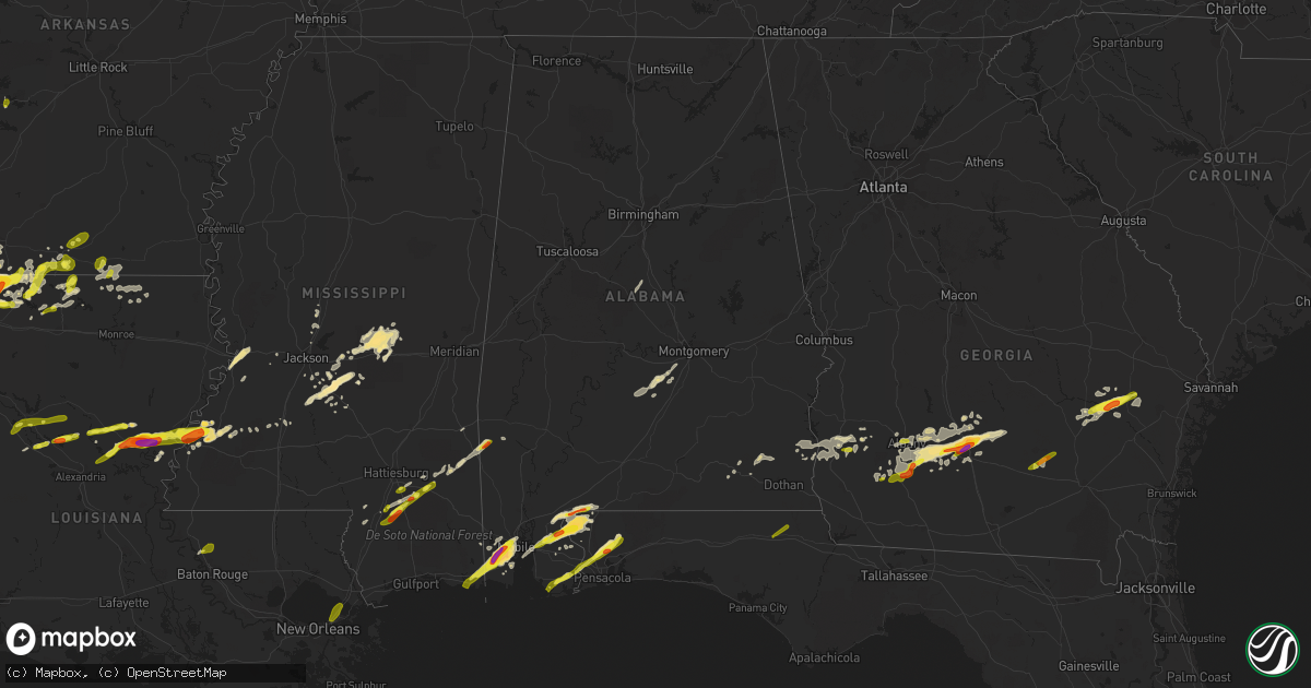
Hail Map in Alabama on January 21, 2017
Get this storm
January 21 map
$229
one time, instant access
Download today. No call, no setup
Keep the $229
Bought the map and want the full workflow? Apply the entire $229 to a subscription within 7 days. None of it is wasted.
Every map, not just this one
This buys you this map. Subscription and you get every map we run, in the markets you choose from a few cities to whole states to nationwide. Plus real-time alerts the moment a storm fires.
Contact data
Name, contact info, occupancy, even credit band for addresses in the footprint. You go from where it hit to who to call.
Become the source they trust
Unlimited branding weather history reports on demand. You already have the documented answer ready for the property owner, and you are the one who showed up with it.
Property data and RoofTrace estimates
Pull up any address you have got, its value and the exact code rules for that jurisdiction, straight from One Click Code. Then RoofTrace estimates the squares, pitch, and roof value, priced the way you price.
Storm reports in Alabama
Alabama
| Date | Description |
|---|---|
| 01/21/201710:44 AM CST | Trees down throughout randolph county. |
| 01/21/201710:40 AM CST | Downed power pole near the corner of hwy 55 and hwy 68 in loxley |
| 01/21/201710:05 AM CST | Widespread reports of trees and powerlines down across lee county. . |
| 01/21/201710:00 AM CST | Tree down on county rd 68. |
| 01/21/20179:52 AM CST | Tree fell on car on matthews ave. |
| 01/21/20179:42 AM CST | Large tree and tin roofing blocking county rd 278 at 4220. . |
| 01/21/20179:32 AM CST | Reports of trees down in louisville along county road 17. Possible tornado. Time estimated from radar. |
| 01/21/20179:30 AM CST | A tornado occurred in pike county and the damage continued into barbour county. The tornado moved eastward and ended just east of louisville. |
| 01/21/20179:23 AM CST | 4 trees down in the northern part of coffee county. |
| 01/21/20179:20 AM CST | A tornado affected areas just southwest of smith station. The tornado was rated an ef1 with winds estimated around 90 mph. The most significant damage occurred at the h |
| 01/21/20179:20 AM CST | A weak tornado damage path was found by emergency management starting just west of the banks feed mill on alabama hwy 93 and going east to county road 4405. Debris sign |
| 01/21/20179:18 AM CST | Damage to roof and athletic field at smiths station high school. Possible tornado. Time estimated by radar. |
| 01/21/20179:10 AM CST | Trees down across george wallace drive in troy. Possible tornado. Time estimated by radar. |
| 01/21/20179:08 AM CST | Ef0 tornado with winds of 80mph briefly touched down north of crawford in the haley woods subdivision causing minor damage to several roofs and wooden fences. Path leng |
| 01/21/20179:05 AM CST | Sheet metal scattered in yard and tree damage north of crawford. Possible tornado. Time estimated by radar. |
| 01/21/20179:00 AM CST | Ef0 tornado with 65 mph winds downed trees and caused shingle damage near state highway 169 in southern opelika. |
| 01/21/20178:56 AM CST | An ef-0 tornado touched down along lee road 413... Causing some shingle damage and uprooting several trees along its brief path toward the northeast... Ending along cr- |
| 01/21/20178:55 AM CST | An ef1 touched down in western pike county and traveled eastward. The damage went across pike county and may have been one than one tornado. Further assessment is neede |
| 01/21/20178:55 AM CST | Tree down on garage near the community of gantt |
| 01/21/20178:50 AM CST | Numerous trees and power lines down. 1 business experienced minor wind damage. |
| 01/21/20178:49 AM CST | Ef0 tornado with 70 mph winds downed trees near sand hill road. |
| 01/21/20178:48 AM CST | Numerous trees down on cr 43... Just on the macon side of the lee/macon county line. Possible tornado. |
| 01/21/20178:48 AM CST | A tornado produced tree and minor roof damage near the lee and macon county line. |
| 01/21/20178:45 AM CST | Widespread reports of trees and powerlines down across lee county. . |
| 01/21/20178:45 AM CST | Multiple trees down across tallapoosa county. Roads were blocked... But have been cleared. . |
| 01/21/20178:29 AM CST | Trees and powerlines down across willow springs rd. Possible tornado. . |
| 01/21/20178:25 AM CST | Trees down along evergreen avenue |
| 01/21/20178:22 AM CST | Trees down on a home on elizabeth street. Another home had slight damage from a fallen tree on garland road. |
| 01/21/20178:20 AM CST | Trees and powerlines down on washington st. In tuskegee. Time estimated by radar. |
| 01/21/20178:18 AM CST | Sheet metal shed blown down... Trees uprooted... And fence blown down in lyeffion... Al on hwy 83. |
| 01/21/20178:18 AM CST | Several trees fallen on homes and trees down between hwy 31 and sowell rd. |
| 01/21/20178:10 AM CST | Barn destroyed along with shingle damage to a home near the intersection of highway 83 and county road 22. Several trees downed. |
| 01/21/20178:05 AM CST | Sheet metal and tree damage north of crawford. This is a correction from previous lsr. Correct location is in lee county. Possible tornado. Time estimated by radar. |
| 01/21/20178:00 AM CST | Several cars shifted and moved into each other due to thunderstorm wind. |
| 01/21/20177:57 AM CST | Reported at 502 main street wetumpka... Al tree down on house. Time estimated by radar. Possible tornado. |
| 01/21/20177:57 AM CST | Powerlines down in redland. Possible tornado. Time estimated by radar. |
| 01/21/20177:57 AM CST | Ef0 briefly touched down near emerald mountain christian school with winds of 75mph... Causing minor damage to fencing and metal siding. Path length 0.59 mile. Path wid |
| 01/21/20177:55 AM CST | An ef1 tornado with winds of 90 mph touched down briefly just south of willow springs rd and moved north northeast causing tree damage. Path length 0.68 mi. Path width |
| 01/21/20177:55 AM CST | A tornado moved through wetumpka and produced tree and structure damage. |
| 01/21/20177:45 AM CST | Trees and powerlines down along hwy 14 in elmore. Possible tornado. Time estimated by radar. |
| 01/21/20177:20 AM CST | Tree snapped in safford... Al. Possible tornado. |
| 01/21/20177:15 AM CST | Large tree on a home on darling lane |
| 01/21/20176:45 AM CST | Tree down across car in sardis... Al. Time estimated by radar. |
| 01/21/20176:45 AM CST | Large pine tree uprooted... Tree limbs snapped...and fence blown down near a public residence. |
| 01/21/20176:04 AM CST | 18-wheeler blown over near benton on u.s. Highway 80. . |
| 01/21/20172:05 AM CST | Tree down in ashford |
| 01/21/20171:42 AM CST | Tree on home in susan moore. |
| 01/21/20171:38 AM CST | Trees down in oneonta. |
| 01/21/20171:38 AM CST | Winds of 70-80 mph caused a damage swath 1.4 miles long and 1000 yds wide in oneonta... Downing 200 trees and damaging or destroying over 60 structures. |
| 01/21/20171:30 AM CST | Tree down on home on 3rd street in hayden. |
| 01/21/20171:29 AM CST | Tree down on home in locust fork. |
| 01/21/20171:18 AM CST | Tree down on i-65 at mm 289. |
| 01/21/20171:14 AM CST | 65 kts gust at kbhm airport. |
| 01/21/20171:09 AM CST | Trees down near mcdonald st in tarrant. |
| 01/21/20171:08 AM CST | Trees down in vestavia hills... Including at us highway 31 and kentucky ave. |
| 01/21/20171:08 AM CST | Trees down near rocky ridge. |
| 01/21/20171:07 AM CST | Trees down in homewood. |
| 01/21/20171:07 AM CST | Tree down on queensview rd. |
| 01/21/20171:01 AM CST | Power lines down near 67th st and pineview rd. |
| 01/21/201712:57 AM CST | Trees and power lines down on 8th place in pleasant grove. |
| 01/21/201712:57 AM CST | Numerous trees down in bessemer. |
| 01/21/201712:50 AM CST | Trees down on buddy vines camp rd. |
| 01/21/201712:47 AM CST | Tree down on hwy 25... Northeast of centreville... At entrance to church drive. Additional trees were knocked down across the county. |
| 01/21/201712:36 AM CST | Brief ef0 with winds of 80mph touched down along hagler coaling rd... Downing a dozen trees. One tree damaged a home. Path length 0.3 mile. Max width 200yds. The durati |
| 01/21/201712:10 AM CST | Tree down along hwy 10 east |
| 01/20/201711:11 PM CST | A few trees down across northeastern portions of the county as well. |
| 01/20/201710:25 PM CST | Hail to the size of quarters was reported in jemison. Time estimated from radar. |
| 01/20/201710:24 PM CST | Quarter size hail reported on county road 57 |
| 01/20/201710:14 PM CST | Quarter sized hail reported in ozark |
| 01/20/20179:15 PM CST | Quarter size hail reported in copeland via social media |
| 01/20/20178:30 PM CST | Tree fell on commercial building in downtown brewton. Time estimated via radar |
| 01/20/20177:18 PM CST | Off duty nws employee reports one inch hail in elberta |
| 01/20/20176:55 PM CST | Off duty nws employee reports 2 inch hail off dawes rd |
All States Impacted by Hail Map on January 21, 2017
Cities Impacted by Hail Map on January 21, 2017
- Magnolia, AR
- Omega, GA
- Forest, MS
- Lena, MS
- Marion, LA
- Haughton, LA
- Cotton Valley, LA
- Minden, LA
- Haynesville, LA
- Sarepta, LA
- Shongaloo, LA
- Theodore, AL
- Grand Bay, AL
- Mobile, AL
- Union, MS
- Walnut Grove, MS
- Monterey, LA
- Hayneville, AL
- Edison, GA
- Bluffton, GA
- Jena, LA
- Hattiesburg, MS
- Vicksburg, MS
- Century, FL
- Bay Minette, AL
- McDavid, FL
- Princeton, LA
- Marshall, TX
- Waskom, TX
- Ferriday, LA
- Jonesville, LA
- Sicily Island, LA
- Pearcy, AR
- Royal, AR
- Hot Springs National Park, AR
- Reidsville, GA
- Surrency, GA
- Glennville, GA
- Baxley, GA
- Natchitoches, LA
- Brandon, MS
- Wesson, MS
- Lucedale, MS
- El Dorado, AR
- Florence, MS
- Stapleton, AL
- Elberta, AL
- Seminole, AL
- Cantonment, FL
- Milton, FL
- Pensacola, FL
- Vivian, LA
- Daphne, AL
- Rebecca, GA
- Albany, GA
- Doerun, GA
- Poulan, GA
- Tifton, GA
- Baconton, GA
- Sumner, GA
- Ashburn, GA
- Sycamore, GA
- Fitzgerald, GA
- Chula, GA
- Ty Ty, GA
- Sylvester, GA
- Ocilla, GA
- Vaughan, MS
- Bastrop, LA
- Natchez, MS
- Zachary, LA
- Fayette, MS
- Union Church, MS
- Lockesburg, AR
- Dierks, AR
- De Queen, AR
- Morgan, GA
- Ludowici, GA
- Leary, GA
- Bivins, TX
- Jefferson, TX
- Trout, LA
- Simms, TX
- De Kalb, TX
- New Boston, TX
- Fort Rucker, AL
- Ozark, AL
- Midland City, AL
- New Brockton, AL
- Enterprise, AL
- Farmerville, LA
- Letohatchee, AL
- Robertsdale, AL
- Mer Rouge, LA
- Benton, LA
- Plain Dealing, LA
- Mooringsport, LA
- Hazlehurst, MS
- Mendenhall, MS
- Magee, MS
- Charleston, MS
- Tutwiler, MS
- Foley, AL
- Brooklyn, MS
- Wiggins, MS
- Lumberton, MS
- Canton, MS
- Stamps, AR
- Harrisonburg, LA
- New Augusta, MS
- Beaumont, MS
- Pearson, GA
- Millry, AL
- Conehatta, MS
- Morton, MS
- Braxton, MS
- Strong, AR
- Huttig, AR
- Emerson, AR
- Maplesville, AL
- Lyons, GA
- Pollock, LA
- Georgetown, LA
- Karnack, TX
- Semmes, AL
- State Line, MS
- Buckatunna, MS
- Richton, MS
- Abbeville, AL
- Shorterville, AL
- Pinola, MS
- Springhill, LA
- Taylor, AR
- Dubach, LA
- Starks, LA
- Ridgeland, MS
- Loxley, AL
- Hope Hull, AL
- Atmore, AL
- Irvington, AL
- Bernice, LA
- Clayton, LA
- Roxie, MS
- Georgetown, MS
- Homer, LA
- Summerfield, LA
- Lisbon, LA
- Spearsville, LA
- Lillie, LA
- Flowood, MS
- Pelahatchie, MS
- Newton, GA
- Lake, MS
- Waynesboro, MS
- Gilliam, LA
- Belcher, LA
- Ida, LA
- Hosston, LA
- Oil City, LA
- Utica, MS
- Raleigh, MS
- Daleville, AL
- Moss Point, MS
- Jackson, MS
- Edwards, MS
- Randolph, AL
- Jemison, AL
- Eight Mile, AL
- Lewisville, AR
- Coleman, GA
- Cuthbert, GA
- Arcadia, LA
- Dry Prong, LA
- Colfax, LA
- Newville, AL
- Rodessa, LA
- Lorman, MS
- Glenwood, AR
- Montgomery, LA
- Atlanta, LA
- Madison, MS
- Douglas, GA
- Nicholls, GA
- Foreman, AR
- Shellman, GA
- Dawson, GA
- Bronwood, GA
- Leesburg, GA
- Minter, AL
- Pine Apple, AL
- Bradley, AR
- Cloutierville, LA
- Poplarville, MS
- Fort Deposit, AL
- Molino, FL
- Flomaton, AL
- Perdido, AL
- Petal, MS
- Purvis, MS
- Athens, LA
- Oakfield, GA
- Warwick, GA
- Junction City, AR
- Camilla, GA
- Arlington, GA
- Fort Gaines, GA
- Blakely, GA
- Harrisville, MS
- Rochelle, GA
- Columbia, AL
- Pattison, MS
- Odum, GA
- Port Gibson, MS
- Willacoochee, GA
- Winnfield, LA
- Lena, LA
- Pineville, LA
- Deville, LA
- Vidalia, LA
- Hampton, AR
- New Orleans, LA
- Slaughter, LA
- Bon Secour, AL
- Pascagoula, MS
- Graceville, FL
- Marianna, FL
- Campbellton, FL
- Cottondale, FL
- Chipley, FL
- Amity, AR


