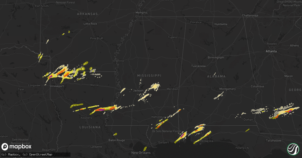
Hail Map in Mississippi on January 21, 2017
Get this storm
January 21 map
$229
one time, instant access
Download today. No call, no setup
Keep the $229
Bought the map and want the full workflow? Apply the entire $229 to a subscription within 7 days. None of it is wasted.
Every map, not just this one
This buys you this map. Subscription and you get every map we run, in the markets you choose from a few cities to whole states to nationwide. Plus real-time alerts the moment a storm fires.
Contact data
Name, contact info, occupancy, even credit band for addresses in the footprint. You go from where it hit to who to call.
Become the source they trust
Unlimited branding weather history reports on demand. You already have the documented answer ready for the property owner, and you are the one who showed up with it.
Property data and RoofTrace estimates
Pull up any address you have got, its value and the exact code rules for that jurisdiction, straight from One Click Code. Then RoofTrace estimates the squares, pitch, and roof value, priced the way you price.
Storm reports in Mississippi
Mississippi
| Date | Description |
|---|---|
| 01/20/201711:29 PM CST | Trees down along koa road |
| 01/20/201711:27 PM CST | Trees and power lines down along greenhill loop road |
| 01/20/201711:14 PM CST | Trees down along i-59 and county road 333 just west of enterprise |
| 01/20/201710:44 PM CST | *** 1 inj *** this ef-2 tornado touched down near russell topton rd and tracked 7.3 mi with a maximum width of 550 yds and maximum winds of 120 mph...and it lifted just |
| 01/20/201710:44 PM CST | Trees down along rabbit road |
| 01/20/201710:41 PM CST | *** 1 inj *** 1 injury sustained in a mobile home due to damaging winds |
| 01/20/201710:41 PM CST | Church was damaged on fred clayton rd. |
| 01/20/201710:38 PM CST | Trees down along sunshine road |
| 01/20/201710:17 PM CST | Multiple trees down along hwy 18 between raleigh and white oak |
| 01/20/20179:40 PM CST | Quarter size hail reported in beaumont with thunderstorm passage. Time estimated via radar |
| 01/20/20179:38 PM CST | Quarter size hail in wesson and beauregard |
| 01/20/20179:35 PM CST | Golf ball hail in the braxton area. |
| 01/20/20179:30 PM CST | Power lines down along hwy 21 north |
| 01/20/20179:20 PM CST | Golf ball hail near hwy 35 and old jackson road in the hillsboro community |
| 01/20/20179:15 PM CST | Quarter size hail in the mclaurin area |
| 01/20/20179:15 PM CST | Quarter size hail in the morton area |
| 01/20/20179:10 PM CST | Tree down across springfield road near the intersection of hwy 13s |
| 01/20/20178:55 PM CST | Nickel to quarter size hail between pelahatchie and the county line |
| 01/20/20178:53 PM CST | Hail to the size of quarters was falling south of lake caroline. |
| 01/20/20178:52 PM CST | Golf ball size hail estimated in the church hill area |
| 01/20/20178:51 PM CST | Tree reported down across kingston rd. |
| 01/20/20178:43 PM CST | A local report indicates 1.00 inch wind near 5 NNW BRANDON |
| 01/20/20178:29 PM CST | One inch hail reported near beaumont |
| 01/20/20178:24 PM CST | Hail to the size of quarters was falling near vicksburg. |
| 01/20/20178:23 PM CST | Hail up to the size of quarters was falling in the robinhood community. |
| 01/20/20178:20 PM CST | Near the vicksburg mall |
| 01/20/20177:54 PM CST | Quarter size hail on pistol ridge road...reported by hattiesburg eoc |
| 01/20/20176:40 PM CST | A local report indicates 1.00 inch wind near MOSS POINT |
All States Impacted by Hail Map on January 21, 2017
Cities Impacted by Hail Map on January 21, 2017
- Magnolia, AR
- Omega, GA
- Forest, MS
- Lena, MS
- Marion, LA
- Haughton, LA
- Cotton Valley, LA
- Minden, LA
- Haynesville, LA
- Sarepta, LA
- Shongaloo, LA
- Theodore, AL
- Grand Bay, AL
- Mobile, AL
- Union, MS
- Walnut Grove, MS
- Monterey, LA
- Hayneville, AL
- Edison, GA
- Bluffton, GA
- Jena, LA
- Hattiesburg, MS
- Vicksburg, MS
- Century, FL
- Bay Minette, AL
- McDavid, FL
- Princeton, LA
- Marshall, TX
- Waskom, TX
- Ferriday, LA
- Jonesville, LA
- Sicily Island, LA
- Pearcy, AR
- Royal, AR
- Hot Springs National Park, AR
- Reidsville, GA
- Surrency, GA
- Glennville, GA
- Baxley, GA
- Natchitoches, LA
- Brandon, MS
- Wesson, MS
- Lucedale, MS
- El Dorado, AR
- Florence, MS
- Stapleton, AL
- Elberta, AL
- Seminole, AL
- Cantonment, FL
- Milton, FL
- Pensacola, FL
- Vivian, LA
- Daphne, AL
- Rebecca, GA
- Albany, GA
- Doerun, GA
- Poulan, GA
- Tifton, GA
- Baconton, GA
- Sumner, GA
- Ashburn, GA
- Sycamore, GA
- Fitzgerald, GA
- Chula, GA
- Ty Ty, GA
- Sylvester, GA
- Ocilla, GA
- Vaughan, MS
- Bastrop, LA
- Natchez, MS
- Zachary, LA
- Fayette, MS
- Union Church, MS
- Lockesburg, AR
- Dierks, AR
- De Queen, AR
- Morgan, GA
- Ludowici, GA
- Leary, GA
- Bivins, TX
- Jefferson, TX
- Trout, LA
- Simms, TX
- De Kalb, TX
- New Boston, TX
- Fort Rucker, AL
- Ozark, AL
- Midland City, AL
- New Brockton, AL
- Enterprise, AL
- Farmerville, LA
- Letohatchee, AL
- Robertsdale, AL
- Mer Rouge, LA
- Benton, LA
- Plain Dealing, LA
- Mooringsport, LA
- Hazlehurst, MS
- Mendenhall, MS
- Magee, MS
- Charleston, MS
- Tutwiler, MS
- Foley, AL
- Brooklyn, MS
- Wiggins, MS
- Lumberton, MS
- Canton, MS
- Stamps, AR
- Harrisonburg, LA
- New Augusta, MS
- Beaumont, MS
- Pearson, GA
- Millry, AL
- Conehatta, MS
- Morton, MS
- Braxton, MS
- Strong, AR
- Huttig, AR
- Emerson, AR
- Maplesville, AL
- Lyons, GA
- Pollock, LA
- Georgetown, LA
- Karnack, TX
- Semmes, AL
- State Line, MS
- Buckatunna, MS
- Richton, MS
- Abbeville, AL
- Shorterville, AL
- Pinola, MS
- Springhill, LA
- Taylor, AR
- Dubach, LA
- Starks, LA
- Ridgeland, MS
- Loxley, AL
- Hope Hull, AL
- Atmore, AL
- Irvington, AL
- Bernice, LA
- Clayton, LA
- Roxie, MS
- Georgetown, MS
- Homer, LA
- Summerfield, LA
- Lisbon, LA
- Spearsville, LA
- Lillie, LA
- Flowood, MS
- Pelahatchie, MS
- Newton, GA
- Lake, MS
- Waynesboro, MS
- Gilliam, LA
- Belcher, LA
- Ida, LA
- Hosston, LA
- Oil City, LA
- Utica, MS
- Raleigh, MS
- Daleville, AL
- Moss Point, MS
- Jackson, MS
- Edwards, MS
- Randolph, AL
- Jemison, AL
- Eight Mile, AL
- Lewisville, AR
- Coleman, GA
- Cuthbert, GA
- Arcadia, LA
- Dry Prong, LA
- Colfax, LA
- Newville, AL
- Rodessa, LA
- Lorman, MS
- Glenwood, AR
- Montgomery, LA
- Atlanta, LA
- Madison, MS
- Douglas, GA
- Nicholls, GA
- Foreman, AR
- Shellman, GA
- Dawson, GA
- Bronwood, GA
- Leesburg, GA
- Minter, AL
- Pine Apple, AL
- Bradley, AR
- Cloutierville, LA
- Poplarville, MS
- Fort Deposit, AL
- Molino, FL
- Flomaton, AL
- Perdido, AL
- Petal, MS
- Purvis, MS
- Athens, LA
- Oakfield, GA
- Warwick, GA
- Junction City, AR
- Camilla, GA
- Arlington, GA
- Fort Gaines, GA
- Blakely, GA
- Harrisville, MS
- Rochelle, GA
- Columbia, AL
- Pattison, MS
- Odum, GA
- Port Gibson, MS
- Willacoochee, GA
- Winnfield, LA
- Lena, LA
- Pineville, LA
- Deville, LA
- Vidalia, LA
- Hampton, AR
- New Orleans, LA
- Slaughter, LA
- Bon Secour, AL
- Pascagoula, MS
- Graceville, FL
- Marianna, FL
- Campbellton, FL
- Cottondale, FL
- Chipley, FL
- Amity, AR


