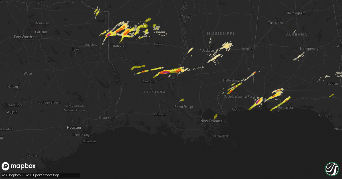
Hail Map in Louisiana on January 21, 2017
Get this storm
January 21 map
$229
one time, instant access
Download today. No call, no setup
Keep the $229
Bought the map and want the full workflow? Apply the entire $229 to a subscription within 7 days. None of it is wasted.
Every map, not just this one
This buys you this map. Subscription and you get every map we run, in the markets you choose from a few cities to whole states to nationwide. Plus real-time alerts the moment a storm fires.
Contact data
Name, contact info, occupancy, even credit band for addresses in the footprint. You go from where it hit to who to call.
Become the source they trust
Unlimited branding weather history reports on demand. You already have the documented answer ready for the property owner, and you are the one who showed up with it.
Property data and RoofTrace estimates
Pull up any address you have got, its value and the exact code rules for that jurisdiction, straight from One Click Code. Then RoofTrace estimates the squares, pitch, and roof value, priced the way you price.
Storm reports in Louisiana
Louisiana
| Date | Description |
|---|---|
| 01/21/20175:58 PM CST | Picture of a tornado with debris taken by public... Along cedar bend road. |
| 01/21/20175:58 PM CST | Second round of hail on conley road... Quarter size |
| 01/21/20175:56 PM CST | *** 1 inj *** an ef2 tornado touched down northeast of natchez uprooting and/or snapping numerous trees and downing powerlines. 5 homes suffered significant damage. Sev |
| 01/21/20175:55 PM CST | Roof is off of a home along patrick road. |
| 01/21/20175:55 PM CST | *** 1 inj *** two homes destroyed along patrick road and hwy 494. A man has a broken arm. |
| 01/21/20175:55 PM CST | An ef-1 tornado with winds estimated between 100-105 mph touched down south of shongaloo along elmer moore road and continued northeast across rodney martin...wortham.. |
| 01/21/20175:50 PM CST | . |
| 01/21/20175:50 PM CST | 2 hail reported in serepta |
| 01/21/20175:50 PM CST | Photo of large hail via ksla facebook. |
| 01/21/20175:50 PM CST | Golf ball size hail reported in springhill. |
| 01/21/20175:50 PM CST | A local report indicates 1.00 inch wind near NATCHITOCHES |
| 01/21/20175:38 PM CST | Multiple trees down on mott road... And structural damage to home. |
| 01/21/20175:35 PM CST | Trees down across hwy 2. . |
| 01/21/20175:30 PM CST | Hail conley road |
| 01/21/20175:15 PM CST | Power lines down. Mobile homes damaged... With people trapped east of plain dealing. |
| 01/21/20175:15 PM CST | Heavy storm damage to several homes n the vicinity of mott rd...pleasant hill rd...and the shiloh area. Multiple reports of down power lines and trees down. No reports |
| 01/21/20175:12 PM CST | *** 1 inj *** an ef2 tornado touched down east southeast of plain dealing louisiana. Structural damage consisted of mobile homes rolled and destroyed and severe damage |
| 01/21/20175:11 PM CST | A local report indicates 1.00 inch wind near 15 ENE NEW ORLEANS |
| 01/21/20175:10 PM CST | Quarter size hail in hosston at i49 and hwy 2. |
| 01/21/20175:09 PM CST | Bossier sheriffs are reporting golf ball size hail in plain dealing. |
| 01/21/20175:05 PM CST | Bossier sheriffs reporting damage in and around plain dealing... Including trees down as well as damage to homes and vehicles. |
| 01/21/20174:55 PM CST | 2 inch hail tweeted from the public. |
| 01/21/20174:55 PM CST | Picture of 2 inch tweeted to the office. |
| 01/21/20176:15 AM CST | Several homes with shingles blown off and fences down on furman drive. |
| 01/20/20179:55 PM CST | 5 utility poles blown over along hwy 165 between mer rouge and bonita |
| 01/20/20179:04 PM CST | This tornado began just west of us 165 north of mer rouge and tracked 9.25 miles northeastward to just southeast of bonita... Ending just east of horace hill rd. Three |
| 01/20/20178:49 PM CST | Power lines down in mer rouge. |
| 01/20/20178:48 PM CST | An ef0 tornado snapped a few small trees at the initial point of touchdown. The tornado moved east northeast and caused considerable damage to a metal shed and before l |
| 01/20/20178:30 PM CST | 2 businesses... Several homes... And 2 vehicles damaged along highway 8... Ending just before 3107. |
| 01/20/20178:29 PM CST | An ef1 tornado touched down snapping trees west of hwy 1304 near hwy 8. A wooden barn was damaged and a uprooted tree fell on a church. A gas station canopy was blown 5 |
| 01/20/20178:15 PM CST | Windshield busted in ambulance due to hail |
| 01/20/20177:51 PM CST | An ef1 tornado touched down south of georgetown downing and/or snapping numerous trees and powerlines. The tornado first touched down on hwy. 165 and moved east northea |
| 01/20/20177:50 PM CST | Trees snapped and uprooted. |
| 01/20/20177:50 PM CST | . |
| 01/20/20177:46 PM CST | Golf ball to baseball size hail reported in jonesville |
| 01/20/20177:45 PM CST | 3.5 inch hail estimated southwest of jonesville just off of hwy 84 |
| 01/20/20177:30 PM CST | 1 inch hail in spearsville. |
| 01/20/20177:28 PM CST | A local report indicates 1.25 inch wind near ARCHIE |
| 01/20/20177:25 PM CST | 1 inch hail in dry prong. |
| 01/20/20177:00 PM CST | Quarter size hail in white hall along hwy 8. |
| 01/20/20177:00 PM CST | *** 1 inj *** en ef1 tornado snapped and/or uprooted numerous trees and downed powerlines northwest of colfax. A single wide mobile home flipped over injuring a woman i |
| 01/20/20176:55 PM CST | A local report indicates 2.50 inch wind near SHONGALOO |
| 01/20/20176:52 PM CST | A local report indicates 1.75 inch wind near SHONGALOO |
| 01/20/20176:30 PM CST | Picture of large hail via ksla facebook. |
| 01/20/20176:20 PM CST | Picture of large hail via ktbs facebook. |
| 01/20/20176:15 PM CST | Public photo of hail at lake claiborne via ksla facebook. |
| 01/20/20176:07 PM CST | A local report indicates 1.00 inch wind near HOSSTON |
All States Impacted by Hail Map on January 21, 2017
Cities Impacted by Hail Map on January 21, 2017
- Magnolia, AR
- Omega, GA
- Forest, MS
- Lena, MS
- Marion, LA
- Haughton, LA
- Cotton Valley, LA
- Minden, LA
- Haynesville, LA
- Sarepta, LA
- Shongaloo, LA
- Theodore, AL
- Grand Bay, AL
- Mobile, AL
- Union, MS
- Walnut Grove, MS
- Monterey, LA
- Hayneville, AL
- Edison, GA
- Bluffton, GA
- Jena, LA
- Hattiesburg, MS
- Vicksburg, MS
- Century, FL
- Bay Minette, AL
- McDavid, FL
- Princeton, LA
- Marshall, TX
- Waskom, TX
- Ferriday, LA
- Jonesville, LA
- Sicily Island, LA
- Pearcy, AR
- Royal, AR
- Hot Springs National Park, AR
- Reidsville, GA
- Surrency, GA
- Glennville, GA
- Baxley, GA
- Natchitoches, LA
- Brandon, MS
- Wesson, MS
- Lucedale, MS
- El Dorado, AR
- Florence, MS
- Stapleton, AL
- Elberta, AL
- Seminole, AL
- Cantonment, FL
- Milton, FL
- Pensacola, FL
- Vivian, LA
- Daphne, AL
- Rebecca, GA
- Albany, GA
- Doerun, GA
- Poulan, GA
- Tifton, GA
- Baconton, GA
- Sumner, GA
- Ashburn, GA
- Sycamore, GA
- Fitzgerald, GA
- Chula, GA
- Ty Ty, GA
- Sylvester, GA
- Ocilla, GA
- Vaughan, MS
- Bastrop, LA
- Natchez, MS
- Zachary, LA
- Fayette, MS
- Union Church, MS
- Lockesburg, AR
- Dierks, AR
- De Queen, AR
- Morgan, GA
- Ludowici, GA
- Leary, GA
- Bivins, TX
- Jefferson, TX
- Trout, LA
- Simms, TX
- De Kalb, TX
- New Boston, TX
- Fort Rucker, AL
- Ozark, AL
- Midland City, AL
- New Brockton, AL
- Enterprise, AL
- Farmerville, LA
- Letohatchee, AL
- Robertsdale, AL
- Mer Rouge, LA
- Benton, LA
- Plain Dealing, LA
- Mooringsport, LA
- Hazlehurst, MS
- Mendenhall, MS
- Magee, MS
- Charleston, MS
- Tutwiler, MS
- Foley, AL
- Brooklyn, MS
- Wiggins, MS
- Lumberton, MS
- Canton, MS
- Stamps, AR
- Harrisonburg, LA
- New Augusta, MS
- Beaumont, MS
- Pearson, GA
- Millry, AL
- Conehatta, MS
- Morton, MS
- Braxton, MS
- Strong, AR
- Huttig, AR
- Emerson, AR
- Maplesville, AL
- Lyons, GA
- Pollock, LA
- Georgetown, LA
- Karnack, TX
- Semmes, AL
- State Line, MS
- Buckatunna, MS
- Richton, MS
- Abbeville, AL
- Shorterville, AL
- Pinola, MS
- Springhill, LA
- Taylor, AR
- Dubach, LA
- Starks, LA
- Ridgeland, MS
- Loxley, AL
- Hope Hull, AL
- Atmore, AL
- Irvington, AL
- Bernice, LA
- Clayton, LA
- Roxie, MS
- Georgetown, MS
- Homer, LA
- Summerfield, LA
- Lisbon, LA
- Spearsville, LA
- Lillie, LA
- Flowood, MS
- Pelahatchie, MS
- Newton, GA
- Lake, MS
- Waynesboro, MS
- Gilliam, LA
- Belcher, LA
- Ida, LA
- Hosston, LA
- Oil City, LA
- Utica, MS
- Raleigh, MS
- Daleville, AL
- Moss Point, MS
- Jackson, MS
- Edwards, MS
- Randolph, AL
- Jemison, AL
- Eight Mile, AL
- Lewisville, AR
- Coleman, GA
- Cuthbert, GA
- Arcadia, LA
- Dry Prong, LA
- Colfax, LA
- Newville, AL
- Rodessa, LA
- Lorman, MS
- Glenwood, AR
- Montgomery, LA
- Atlanta, LA
- Madison, MS
- Douglas, GA
- Nicholls, GA
- Foreman, AR
- Shellman, GA
- Dawson, GA
- Bronwood, GA
- Leesburg, GA
- Minter, AL
- Pine Apple, AL
- Bradley, AR
- Cloutierville, LA
- Poplarville, MS
- Fort Deposit, AL
- Molino, FL
- Flomaton, AL
- Perdido, AL
- Petal, MS
- Purvis, MS
- Athens, LA
- Oakfield, GA
- Warwick, GA
- Junction City, AR
- Camilla, GA
- Arlington, GA
- Fort Gaines, GA
- Blakely, GA
- Harrisville, MS
- Rochelle, GA
- Columbia, AL
- Pattison, MS
- Odum, GA
- Port Gibson, MS
- Willacoochee, GA
- Winnfield, LA
- Lena, LA
- Pineville, LA
- Deville, LA
- Vidalia, LA
- Hampton, AR
- New Orleans, LA
- Slaughter, LA
- Bon Secour, AL
- Pascagoula, MS
- Graceville, FL
- Marianna, FL
- Campbellton, FL
- Cottondale, FL
- Chipley, FL
- Amity, AR


