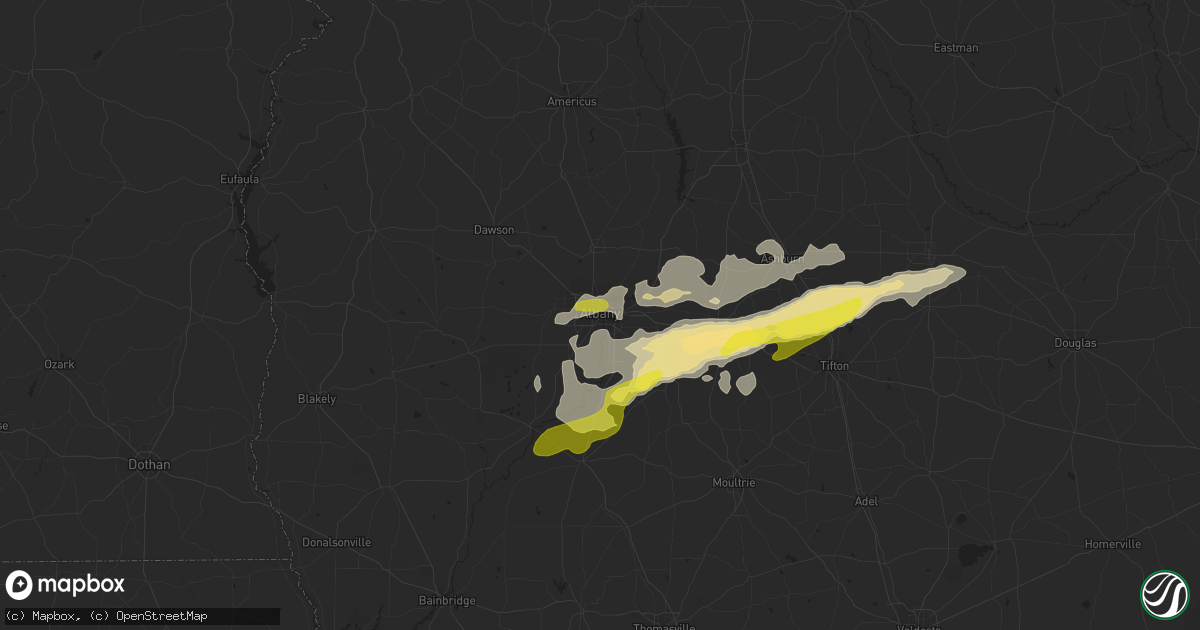
Hail Map in Albany, GA on January 21, 2017
Get this storm
January 21 map
$229
one time, instant access
Download today. No call, no setup
Keep the $229
Bought the map and want the full workflow? Apply the entire $229 to a subscription within 7 days. None of it is wasted.
Every map, not just this one
This buys you this map. Subscription and you get every map we run, in the markets you choose from a few cities to whole states to nationwide. Plus real-time alerts the moment a storm fires.
Contact data
Name, contact info, occupancy, even credit band for addresses in the footprint. You go from where it hit to who to call.
Become the source they trust
Unlimited branding weather history reports on demand. You already have the documented answer ready for the property owner, and you are the one who showed up with it.
Property data and RoofTrace estimates
Pull up any address you have got, its value and the exact code rules for that jurisdiction, straight from One Click Code. Then RoofTrace estimates the squares, pitch, and roof value, priced the way you price.
Storm reports in Albany, GA
Albany, GA
| Date | Description |
|---|---|
| 01/21/201712:02 PM CST | Tree down near gaines ave |
| 01/21/201711:40 AM CST | Stop sign blown over and tree fell on top of 2 cars on gleneagles dr |
| 01/21/201711:35 AM CST | Tree down at 3rd ave and dawson rd. |
| 01/21/201711:35 AM CST | Trees down blocking spring flats rd west of county line rd. |
| 01/21/201711:35 AM CST | Trees down blocking 400 block of mud creek rd. |
| 01/21/20171:17 AM CST | Reports of trees and power lines down |
| 01/20/201711:45 PM CST | 1 inch hail reported in albany |
| 01/20/201710:15 PM CST | Quarter size hail on south county line road |
All States Impacted by Hail Map on January 21, 2017
All Cities Impacted by Hail Map on January 21, 2017
- Magnolia, AR
- Omega, GA
- Forest, MS
- Lena, MS
- Marion, LA
- Haughton, LA
- Cotton Valley, LA
- Minden, LA
- Haynesville, LA
- Sarepta, LA
- Shongaloo, LA
- Theodore, AL
- Grand Bay, AL
- Mobile, AL
- Union, MS
- Walnut Grove, MS
- Monterey, LA
- Hayneville, AL
- Edison, GA
- Bluffton, GA
- Jena, LA
- Hattiesburg, MS
- Vicksburg, MS
- Century, FL
- Bay Minette, AL
- McDavid, FL
- Princeton, LA
- Marshall, TX
- Waskom, TX
- Ferriday, LA
- Jonesville, LA
- Sicily Island, LA
- Pearcy, AR
- Royal, AR
- Hot Springs National Park, AR
- Reidsville, GA
- Surrency, GA
- Glennville, GA
- Baxley, GA
- Natchitoches, LA
- Brandon, MS
- Wesson, MS
- Lucedale, MS
- El Dorado, AR
- Florence, MS
- Stapleton, AL
- Elberta, AL
- Seminole, AL
- Cantonment, FL
- Milton, FL
- Pensacola, FL
- Vivian, LA
- Daphne, AL
- Rebecca, GA
- Albany, GA
- Doerun, GA
- Poulan, GA
- Tifton, GA
- Baconton, GA
- Sumner, GA
- Ashburn, GA
- Sycamore, GA
- Fitzgerald, GA
- Chula, GA
- Ty Ty, GA
- Sylvester, GA
- Ocilla, GA
- Vaughan, MS
- Bastrop, LA
- Natchez, MS
- Zachary, LA
- Fayette, MS
- Union Church, MS
- Lockesburg, AR
- Dierks, AR
- De Queen, AR
- Morgan, GA
- Ludowici, GA
- Leary, GA
- Bivins, TX
- Jefferson, TX
- Trout, LA
- Simms, TX
- De Kalb, TX
- New Boston, TX
- Fort Rucker, AL
- Ozark, AL
- Midland City, AL
- New Brockton, AL
- Enterprise, AL
- Farmerville, LA
- Letohatchee, AL
- Robertsdale, AL
- Mer Rouge, LA
- Benton, LA
- Plain Dealing, LA
- Mooringsport, LA
- Hazlehurst, MS
- Mendenhall, MS
- Magee, MS
- Charleston, MS
- Tutwiler, MS
- Foley, AL
- Brooklyn, MS
- Wiggins, MS
- Lumberton, MS
- Canton, MS
- Stamps, AR
- Harrisonburg, LA
- New Augusta, MS
- Beaumont, MS
- Pearson, GA
- Millry, AL
- Conehatta, MS
- Morton, MS
- Braxton, MS
- Strong, AR
- Huttig, AR
- Emerson, AR
- Maplesville, AL
- Lyons, GA
- Pollock, LA
- Georgetown, LA
- Karnack, TX
- Semmes, AL
- State Line, MS
- Buckatunna, MS
- Richton, MS
- Abbeville, AL
- Shorterville, AL
- Pinola, MS
- Springhill, LA
- Taylor, AR
- Dubach, LA
- Starks, LA
- Ridgeland, MS
- Loxley, AL
- Hope Hull, AL
- Atmore, AL
- Irvington, AL
- Bernice, LA
- Clayton, LA
- Roxie, MS
- Georgetown, MS
- Homer, LA
- Summerfield, LA
- Lisbon, LA
- Spearsville, LA
- Lillie, LA
- Flowood, MS
- Pelahatchie, MS
- Newton, GA
- Lake, MS
- Waynesboro, MS
- Gilliam, LA
- Belcher, LA
- Ida, LA
- Hosston, LA
- Oil City, LA
- Utica, MS
- Raleigh, MS
- Daleville, AL
- Moss Point, MS
- Jackson, MS
- Edwards, MS
- Randolph, AL
- Jemison, AL
- Eight Mile, AL
- Lewisville, AR
- Coleman, GA
- Cuthbert, GA
- Arcadia, LA
- Dry Prong, LA
- Colfax, LA
- Newville, AL
- Rodessa, LA
- Lorman, MS
- Glenwood, AR
- Montgomery, LA
- Atlanta, LA
- Madison, MS
- Douglas, GA
- Nicholls, GA
- Foreman, AR
- Shellman, GA
- Dawson, GA
- Bronwood, GA
- Leesburg, GA
- Minter, AL
- Pine Apple, AL
- Bradley, AR
- Cloutierville, LA
- Poplarville, MS
- Fort Deposit, AL
- Molino, FL
- Flomaton, AL
- Perdido, AL
- Petal, MS
- Purvis, MS
- Athens, LA
- Oakfield, GA
- Warwick, GA
- Junction City, AR
- Camilla, GA
- Arlington, GA
- Fort Gaines, GA
- Blakely, GA
- Harrisville, MS
- Rochelle, GA
- Columbia, AL
- Pattison, MS
- Odum, GA
- Port Gibson, MS
- Willacoochee, GA
- Winnfield, LA
- Lena, LA
- Pineville, LA
- Deville, LA
- Vidalia, LA
- Hampton, AR
- New Orleans, LA
- Slaughter, LA
- Bon Secour, AL
- Pascagoula, MS
- Graceville, FL
- Marianna, FL
- Campbellton, FL
- Cottondale, FL
- Chipley, FL
- Amity, AR


