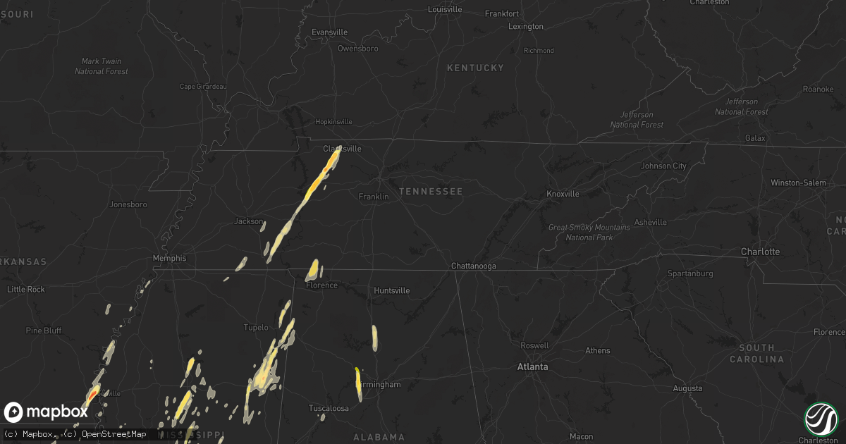
Hail Map in Tennessee on October 13, 2014
Get this storm
October 13 map
$229
one time, instant access
Download today. No call, no setup
Keep the $229
Bought the map and want the full workflow? Apply the entire $229 to a subscription within 7 days. None of it is wasted.
Every map, not just this one
This buys you this map. Subscription and you get every map we run, in the markets you choose from a few cities to whole states to nationwide. Plus real-time alerts the moment a storm fires.
Contact data
Name, contact info, occupancy, even credit band for addresses in the footprint. You go from where it hit to who to call.
Become the source they trust
Unlimited branding weather history reports on demand. You already have the documented answer ready for the property owner, and you are the one who showed up with it.
Property data and RoofTrace estimates
Pull up any address you have got, its value and the exact code rules for that jurisdiction, straight from One Click Code. Then RoofTrace estimates the squares, pitch, and roof value, priced the way you price.
Storm reports in Tennessee
Tennessee
| Date | Description |
|---|---|
| 10/13/20146:35 PM CDT | Large tree limbs down on tyree springs road between white house and hendersonville |
| 10/13/20146:25 PM CDT | Tree down on irvin rd with power outages |
| 10/13/20146:25 PM CDT | Tree and power line down at highway 100 and old locus reek road |
| 10/13/20146:22 PM CDT | Report via facebook shows a tree snapped on jefferson street. |
| 10/13/20146:10 PM CDT | Trees down across indian hills court at meadow circle. Possible tornado. |
| 10/13/20146:10 PM CDT | Tree and power line down on trenton road. Power out to over 1000 people. |
| 10/13/20146:10 PM CDT | Tree down on mobile home in prewitts mobile home park |
| 10/13/20146:10 PM CDT | Tree fell and damaged roof of home in new providence area |
| 10/13/20146:10 PM CDT | Numerous trees down and stop sign blown over with power outages around intersection of richview road at sentinel drive. Possible tornado. |
| 10/13/20146:09 PM CDT | An nws storm survey team found ef-1 tornado damage a few miles southeast of clarksville. The tornado touched down around 609 pm monday evening just north of highway 76 |
| 10/13/20146:08 PM CDT | Trees and power lines down on chesterfield drive with one tree into a home. Possible tornado. |
| 10/13/20146:05 PM CDT | Report of 60 mph winds at boston theta road at robinson road |
| 10/13/20146:00 PM CDT | Trees reported down across the county including neely hollow...campbellsville pike...santa fe...mt pleasant...and columbia.c |
| 10/13/20145:55 PM CDT | Large tree down that crushed iron fence on columbia academy campus at w 7th st and academy ln |
| 10/13/20145:55 PM CDT | Dispatch reported trees down at lower crooked creek rd and roane creek rd. |
| 10/13/20145:52 PM CDT | A local report indicates 1.75 inch wind near PALMYRA |
| 10/13/20145:50 PM CDT | Trees down on bucks smith road |
| 10/13/20145:50 PM CDT | Several large trees down in glenstone subdivision on campbellsville pike south of columbia |
| 10/13/20145:45 PM CDT | Tree down on highway 13 by marlowe road |
| 10/13/20145:40 PM CDT | Golf ball size hail with damage to vehicles |
| 10/13/20145:38 PM CDT | Golf ball size hail broke windows in vehicles in the northeast part of the county. Time based on radar. |
| 10/13/20145:36 PM CDT | An nws storm survey found straight line wind damage across eastern houston county in the area of bailey hollow road...iemay road...old highway 49...and proctor road. A |
| 10/13/20145:35 PM CDT | Tree down in downtown lynnville |
| 10/13/20145:35 PM CDT | Trees down in lawrenceburg on guard drive and revelo road. |
| 10/13/20145:35 PM CDT | Dispatch reported trees down near salmon branch rd and highway 49. |
| 10/13/20145:33 PM CDT | Power lines down west of loretto |
| 10/13/20145:28 PM CDT | Tree snapped. |
| 10/13/20145:20 PM CDT | Trees on power lines between st joe and iron city. Also trees fell on a house in iron city. |
| 10/13/20145:18 PM CDT | Quarter size hail reported between waverly and lobelville on highway 13 |
| 10/13/20145:15 PM CDT | Tree fell on home in waverly causing major damage to roof and broken windows |
| 10/13/20145:15 PM CDT | Golf ball size hail reported in waverly |
| 10/13/20145:05 PM CDT | Public reported quarter size hail on highway 13 between lobelville and waverly. |
| 10/13/20144:18 PM CDT | Multiple trees and power lines down in sardis tennessee area. |
| 10/13/20144:15 PM CDT | A few trees down just inside the county line on hwy 100. |
| 10/13/20143:56 PM CDT | Half dollar size hail hwy 22 one mile north of milledgeville. |
| 10/13/20143:29 PM CDT | Trees and power lines down on why 87. Several homes with damage on joe barfield road. From social media. |
| 10/13/20143:20 PM CDT | Ems radio traffic reports tornado in ramer. |
| 10/13/20142:40 PM CDT | Damage to structures on b johnson rd. No injuries reported. Initial reports were tornado. Survey by ema showed straight line winds so this report was amended. |
| 10/13/20142:40 PM CDT | Damage to structures on b johnson rd. No injuries reported. |
| 10/13/20142:15 PM CDT | Damage to roof at kroger on lake road. Trees down and roads blocked at owen drive and pennell lane. |
| 10/13/20142:00 AM CDT | One tree down near etowah. |
| 10/13/201412:00 AM CDT | Several trees down along hwy 27. |
| 10/12/201411:50 PM CDT | Tree down in roadway. |
| 10/12/20149:45 PM CDT | Lebanon police relayed a report from the public of power lines down at 314 hobbs ave. |
| 10/12/20149:00 PM CDT | 5th and church street closed due to large tree branches down in roadway and tree on powerlines |
| 10/12/20148:57 PM CDT | Tree down in eastbound lane of henpeck lane about 1/4 mile from columbia ave |
| 10/12/20148:55 PM CDT | Tree across roadway at goose creek bypass and mclemore road |
| 10/12/20148:35 PM CDT | A transformer was on fire on owens dr. A tree fell on a home on crestview dr. And a tree was in the road on elk ridge rd. |
| 10/12/20148:27 PM CDT | A tree was down on campbellsville rd at the giles county line. |
| 10/12/20148:21 PM CDT | A tree was blocking the road at highway 166 and pisgah rd. |
| 10/12/20147:02 PM CDT | Dispatch reported downed power lines trees and traffic light in the lyles community. |
All States Impacted by Hail Map on October 13, 2014
Cities Impacted by Hail Map on October 13, 2014
- Bastrop, LA
- Mer Rouge, LA
- Starkville, MS
- Tremont, MS
- Smithville, MS
- Columbus, MS
- Canton, MS
- Roxie, MS
- Calhoun, LA
- Downsville, LA
- Rosedale, MS
- Watson, AR
- Rohwer, AR
- Duncan, MS
- Snow Lake, AR
- Gunnison, MS
- Middleton, TN
- Gore Springs, MS
- Grenada, MS
- Duck Hill, MS
- West Point, MS
- McCarley, MS
- Amory, MS
- Vaiden, MS
- West, MS
- Sumrall, MS
- Navarre, FL
- Jackson, MS
- Raymond, MS
- Terry, MS
- Byram, MS
- Lexington, MS
- Sidon, MS
- Cruger, MS
- Coila, MS
- Eudora, AR
- Gonzales, LA
- Oak Grove, LA
- Pioneer, LA
- Durant, MS
- Winona, MS
- Greenville, MS
- Portland, AR
- Lake Village, AR
- Iron City, TN
- Florence, AL
- Cypress Inn, TN
- Waterloo, AL
- Hamilton, MS
- Aberdeen, MS
- Fulton, MS
- Dennis, MS
- Belmont, MS
- Golden, MS
- Holladay, TN
- Decaturville, TN
- Lobelville, TN
- Stantonville, TN
- Reagan, TN
- McEwen, TN
- Parsons, TN
- Vanleer, TN
- Selmer, TN
- Palmyra, TN
- Morris Chapel, TN
- Woodlawn, TN
- Clarksville, TN
- Scotts Hill, TN
- Sugar Tree, TN
- Erin, TN
- Enville, TN
- Hurricane Mills, TN
- Waverly, TN
- Sardis, TN
- Cumberland Furnace, TN
- Milledgeville, TN
- Cumberland City, TN
- Adamsville, TN
- Saltillo, TN
- Cunningham, TN
- Eastpoint, FL
- Prairie, MS
- Camden, MS
- Sallis, MS
- Adger, AL
- Quinton, AL
- McCalla, AL
- Cordova, AL
- Mulga, AL
- Bessemer, AL
- Jonesville, LA
- Monterey, LA
- Bay Saint Louis, MS
- Waveland, MS
- Lorman, MS
- West Monroe, LA
- Farmerville, LA
- Weir, MS
- McCool, MS
- Carrollton, MS
- Call, TX
- Louisville, MS
- Coffeeville, MS
- Cullman, AL
- Hanceville, AL
- Vicksburg, MS
- Crosby, MS
- Hamilton, AL
- Vina, AL
- Greenwood Springs, MS
- Philadelphia, MS
- Vinemont, AL
- Collinston, LA
- Edwards, MS
- Utica, MS
- Emerson, AR
- Petal, MS
- Pine Hill, AL
- Arlington, AL
- Thomasville, AL
- Hayden, AL
- Florence, MS
- Marvell, AR
- Holly Grove, AR
- Yazoo City, MS
- Finger, TN
- Bethel Springs, TN
- Tunica, MS
- Marianna, AR
- Decatur, MS
- Jones, LA
- Fosters, AL
- Kosciusko, MS
- Ethel, MS
- Grapeland, TX
- Rayville, LA
- Oak Ridge, LA
- Benton, MS
- Hollandale, MS
- Carthage, MS
- Hermanville, MS
- Pinola, MS
- Vaughan, MS
- Monroe, LA
- Goodman, MS
- Loranger, LA
- Folsom, LA
- Guys, TN
- Ramer, TN
- Steens, MS
- Mississippi State, MS
- Caledonia, MS
- Red Bay, AL
- Crawford, MS
- Macon, MS
- Morton, MS
- Detroit, AL
- Sulligent, AL
- Wisner, LA
- Luray, TN
- Beech Bluff, TN
- Henderson, TN
- Rolling Fork, MS
- Deridder, LA
- Franklinton, LA
- Bonita, LA
- Dora, AL
- Minter City, MS
- Lutts, TN
- Pelahatchie, MS
- Lena, MS
- Thomaston, AL
- Anguilla, MS
- Amite, LA
- Estherwood, LA
- Crowley, LA
- Morse, LA
- Boyce, LA
- Kilmichael, MS
- Magnolia, AR
- Sterlington, LA
- Stewart, MS
- Ellisville, MS
- Seminary, MS
- Ashland, MS
- Robinsonville, MS
- Pickens, MS
- Ralph, AL
- Flatwoods, LA
- Mora, LA
- French Camp, MS
- Eupora, MS
- Woodville, TX
- Hillister, TX
- Helena, AR
- Deatsville, AL
- Prattville, AL
- Walnut Grove, MS
- Houston, TX
- Taylor, AR
- Ackerman, MS
- Dermott, AR
- Benoit, MS
- Parkdale, AR
- Kirbyville, TX
- Opelousas, LA
- Braxton, MS
- Charleston, MS
- Fred, TX
- Spurger, TX
- Walnut, MS
- Galena Park, TX
- Meadville, MS
- Newton, MS
- Clarksdale, MS
- Port Gibson, MS
- Tallulah, LA


