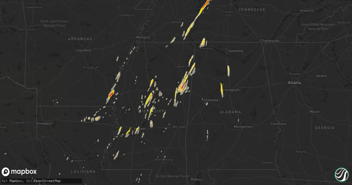
Hail Map on October 13, 2014
Get this storm
October 13 map
$229
one time, instant access
Download today. No call, no setup
Keep the $229
Bought the map and want the full workflow? Apply the entire $229 to a subscription within 7 days. None of it is wasted.
Every map, not just this one
This buys you this map. Subscription and you get every map we run, in the markets you choose from a few cities to whole states to nationwide. Plus real-time alerts the moment a storm fires.
Contact data
Name, contact info, occupancy, even credit band for addresses in the footprint. You go from where it hit to who to call.
Become the source they trust
Unlimited branding weather history reports on demand. You already have the documented answer ready for the property owner, and you are the one who showed up with it.
Property data and RoofTrace estimates
Pull up any address you have got, its value and the exact code rules for that jurisdiction, straight from One Click Code. Then RoofTrace estimates the squares, pitch, and roof value, priced the way you price.
States Impacted by Hail Map on October 13, 2014
Storm reports
Mississippi
| Date | Description |
|---|---|
| 10/13/20146:44 PM CDT | Tree down through a house |
| 10/13/20145:56 PM CDT | Tree down across s bound lane of hwy 49. |
| 10/13/20145:30 PM CDT | Some trees fell on powerlines on yellowjacket road on the campus of starkville high school. |
| 10/13/20145:28 PM CDT | Tree down on pine rd |
| 10/13/20145:15 PM CDT | Tree down |
| 10/13/20145:15 PM CDT | Tree down on airport rd |
| 10/13/20145:10 PM CDT | Trees down along hwy 10 and 47. |
| 10/13/20145:09 PM CDT | Multiple trees down east of mccomb. |
| 10/13/20145:05 PM CDT | Tree down blocking 1 lane of hwy 15 |
| 10/13/20145:04 PM CDT | Reported by msu meteorology |
| 10/13/20145:02 PM CDT | Numerous trees snapped north side of starkville...likely due to microburst. Some trees on cars and powerlines. Msu meteorologist on scene estimates 75 to 80 mph winds o |
| 10/13/20144:50 PM CDT | A few trees down on robinwood rd |
| 10/13/20144:45 PM CDT | Approx 25 trees down with 3 on homes. Three hanging street lights were blown away. Damage was on the north side along hwy 45. |
| 10/13/20144:44 PM CDT | On kincaid rd |
| 10/13/20144:42 PM CDT | Several trees snapped along hwy 45 north of columbus |
| 10/13/20144:42 PM CDT | A local report indicates 1.25 inch wind near 2 SE TREMONT |
| 10/13/20144:42 PM CDT | Tree down at a residence in columbus. Report relayed from social media. |
| 10/13/20144:40 PM CDT | Several trees down |
| 10/13/20144:30 PM CDT | Power line down along hwy 12 |
| 10/13/20144:25 PM CDT | Numerous trees and powerlines down in southern end of monroe county. |
| 10/13/20144:23 PM CDT | Several trees down and minor roof damage on hwy 25. |
| 10/13/20144:15 PM CDT | Trees and power lines down |
| 10/13/20144:15 PM CDT | At least 10 utility poles were snapped in noxubee county |
| 10/13/20144:15 PM CDT | A couple trees down |
| 10/13/20144:15 PM CDT | Trees and power lines down |
| 10/13/20144:11 PM CDT | A local report indicates 1.25 inch wind near HATLEY |
| 10/13/20144:06 PM CDT | Trees and power lines down |
| 10/13/20144:02 PM CDT | Tree down |
| 10/13/20144:00 PM CDT | A few trees down |
| 10/13/20143:58 PM CDT | Tree down |
| 10/13/20143:58 PM CDT | A few trees down |
| 10/13/20143:57 PM CDT | A few trees down |
| 10/13/20143:56 PM CDT | A local report indicates 1.00 inch wind near 3 W FORKVILLE |
| 10/13/20143:54 PM CDT | Trees down and power outages |
| 10/13/20143:33 PM CDT | A local report indicates 2.00 inch wind near 4 ESE WEST POINT |
| 10/13/20143:32 PM CDT | Nickel to quarter size on greenway dr. |
| 10/13/20143:25 PM CDT | A few trees down |
| 10/13/20143:22 PM CDT | A few trees down on dentville rd |
| 10/13/20143:15 PM CDT | 3 to 4 trees were blown down |
| 10/13/20143:12 PM CDT | A few trees down on martinsville rd |
| 10/13/20143:10 PM CDT | Tree down in town |
| 10/13/20143:10 PM CDT | Tree down |
| 10/13/20143:07 PM CDT | A local report indicates 1.50 inch wind near 4 E GRENADA |
| 10/13/20143:05 PM CDT | A few trees down along hwy 35 |
| 10/13/20143:05 PM CDT | A local report indicates 1.00 inch wind near 2 N VAIDEN |
| 10/13/20143:00 PM CDT | A few trees down and many large limbs and tree debris. |
| 10/13/20143:00 PM CDT | A local report indicates 1.00 inch wind near 4 E MCNAIR |
| 10/13/20143:00 PM CDT | Occurred at rest stop along i-55...relayed by nws employee... |
| 10/13/20142:52 PM CDT | A local report indicates 1.00 inch wind near 8 W RAYMOND |
| 10/13/20142:40 PM CDT | At intersection of bill strong and port gibson roads |
| 10/13/20142:27 PM CDT | Trees down across old port gibson rd |
| 10/13/20142:10 PM CDT | Trees down across barland rd |
| 10/13/20142:09 PM CDT | I-20 and halls ferry road |
| 10/13/20141:37 PM CDT | Tree down on sullivan dr. In waynesboro. |
| 10/13/20141:26 PM CDT | Tree down hwy 63 at perry dr. |
| 10/13/20141:00 PM CDT | Major roof damage to a warehouse storage facility along mississippi river |
| 10/13/201412:42 PM CDT | Power line down |
| 10/12/20147:30 PM CDT | A couple of trees were down. |
| 10/12/20147:18 PM CDT | Report of a tree down blocking a roadway on north frontage road in meridian. |
| 10/12/20147:00 PM CDT | A few trees down across roads in hattiesburg and petal. |
| 10/12/20147:00 PM CDT | Power lines downed in the sandersville rd area |
Georgia
| Date | Description |
|---|---|
| 10/13/20146:55 AM CDT | Scattered trees down around the city of toccoa. |
| 10/13/20146:55 AM CDT | Multiple trees down around eastanolee with trees down on power lines at freeman creek road. |
| 10/13/20146:10 AM CDT | Em reports multiple trees and powerlines down in the vicinity of chandler road. Barn damage was also noted and several homes had shingle damage. |
| 10/13/20145:47 AM CDT | 911 call center recieved reports of several trees down located on county line road...county line trail...pitts chapel road...and post road. |
| 10/13/20145:40 AM CDT | Multiple trees were reported down...some on power lines. The roads affected were sr53 and sr136. |
| 10/13/20145:10 AM CDT | 911 call center reports one tree down near the intersection of highway 247 south and kovac road. |
| 10/13/20145:05 AM CDT | Ema received report of one tree down at the intersection of south old peachtree road and south berkley lake road. |
| 10/13/20145:05 AM CDT | Ema received report of one tree down at the intersection of hamilton mill road and thrasher road. Another tree was reported down near the intersection of hamilton mill |
| 10/13/20145:00 AM CDT | 911 call center reports one tree down on white oak lane. |
| 10/13/20145:00 AM CDT | 911 call center reports one tree down near the intersection of highway 247 south and kovac road. |
| 10/13/20144:56 AM CDT | Over a dozen trees reported down in the alpharetta area. Street locations include mayfield road...bethany road...bethany bend road...and crabapple road. Power lines wer |
| 10/13/20144:55 AM CDT | An nws survey team determined an ef1 tornado with maximum winds of 105 mph touched down 2 miles west of alpharetta and traveled 7.5 miles through milton before lifting |
| 10/13/20144:55 AM CDT | Several trees were reported down on two houses. The streets affected were harris and rucker roads. |
| 10/13/20144:43 AM CDT | An nws survey team determined an ef1 tornado with maximum winds of 95 mph touched down 8 miles nw of sandy springs and traveled 1.25 miles affecting portions of cobb an |
| 10/13/20144:38 AM CDT | News media reported a gust of 60 mph measured by weather equipment at the lovett school. |
| 10/13/20144:33 AM CDT | An nws survey team determined an ef0 tornado with maximum winds of 75 mph touched down 2 miles sse of the vinings and traveled 1 mile before lifting 1 mile sse of the v |
| 10/13/20144:23 AM CDT | There were multiple trees down on ben hill road and stone road. Wires were reported down on fairburn road. |
| 10/13/20144:20 AM CDT | An nws survey team determined an ef0 tornado with maximum winds of 80 mph touched down 1 mile west of east point an traveled 3 miles before lifting 2.5 miles nnw of eas |
| 10/13/20144:15 AM CDT | An nws survey team determined an ef0 tornado with maximum winds of 75 mph touched down 5 miles west of college park and traveled 2.5 miles before lifting 4 miles wnw of |
| 10/13/20143:40 AM CDT | An nws survey team determined an ef1 tornado with maximum winds of 100 mph touched down 1 mile southwest of shiloh and traveled northeast 5.9 miles into northwest talbo |
| 10/13/20143:00 AM CDT | Multiple trees were reported down south east of blue ridge. Dozens of trees were down county wide as well. |
Tennessee
| Date | Description |
|---|---|
| 10/13/20146:35 PM CDT | Large tree limbs down on tyree springs road between white house and hendersonville |
| 10/13/20146:25 PM CDT | Tree and power line down at highway 100 and old locus reek road |
| 10/13/20146:25 PM CDT | Tree down on irvin rd with power outages |
| 10/13/20146:22 PM CDT | Report via facebook shows a tree snapped on jefferson street. |
| 10/13/20146:10 PM CDT | Tree and power line down on trenton road. Power out to over 1000 people. |
| 10/13/20146:10 PM CDT | Tree down on mobile home in prewitts mobile home park |
| 10/13/20146:10 PM CDT | Tree fell and damaged roof of home in new providence area |
| 10/13/20146:10 PM CDT | Numerous trees down and stop sign blown over with power outages around intersection of richview road at sentinel drive. Possible tornado. |
| 10/13/20146:10 PM CDT | Trees down across indian hills court at meadow circle. Possible tornado. |
| 10/13/20146:09 PM CDT | An nws storm survey team found ef-1 tornado damage a few miles southeast of clarksville. The tornado touched down around 609 pm monday evening just north of highway 76 |
| 10/13/20146:08 PM CDT | Trees and power lines down on chesterfield drive with one tree into a home. Possible tornado. |
| 10/13/20146:05 PM CDT | Report of 60 mph winds at boston theta road at robinson road |
| 10/13/20146:00 PM CDT | Trees reported down across the county including neely hollow...campbellsville pike...santa fe...mt pleasant...and columbia.c |
| 10/13/20145:55 PM CDT | Dispatch reported trees down at lower crooked creek rd and roane creek rd. |
| 10/13/20145:55 PM CDT | Large tree down that crushed iron fence on columbia academy campus at w 7th st and academy ln |
| 10/13/20145:52 PM CDT | A local report indicates 1.75 inch wind near PALMYRA |
| 10/13/20145:50 PM CDT | Trees down on bucks smith road |
| 10/13/20145:50 PM CDT | Several large trees down in glenstone subdivision on campbellsville pike south of columbia |
| 10/13/20145:45 PM CDT | Tree down on highway 13 by marlowe road |
| 10/13/20145:40 PM CDT | Golf ball size hail with damage to vehicles |
| 10/13/20145:38 PM CDT | Golf ball size hail broke windows in vehicles in the northeast part of the county. Time based on radar. |
| 10/13/20145:36 PM CDT | An nws storm survey found straight line wind damage across eastern houston county in the area of bailey hollow road...iemay road...old highway 49...and proctor road. A |
| 10/13/20145:35 PM CDT | Trees down in lawrenceburg on guard drive and revelo road. |
| 10/13/20145:35 PM CDT | Tree down in downtown lynnville |
| 10/13/20145:35 PM CDT | Dispatch reported trees down near salmon branch rd and highway 49. |
| 10/13/20145:33 PM CDT | Power lines down west of loretto |
| 10/13/20145:28 PM CDT | Tree snapped. |
| 10/13/20145:20 PM CDT | Trees on power lines between st joe and iron city. Also trees fell on a house in iron city. |
| 10/13/20145:18 PM CDT | Quarter size hail reported between waverly and lobelville on highway 13 |
| 10/13/20145:15 PM CDT | Tree fell on home in waverly causing major damage to roof and broken windows |
| 10/13/20145:15 PM CDT | Golf ball size hail reported in waverly |
| 10/13/20145:05 PM CDT | Public reported quarter size hail on highway 13 between lobelville and waverly. |
| 10/13/20144:18 PM CDT | Multiple trees and power lines down in sardis tennessee area. |
| 10/13/20144:15 PM CDT | A few trees down just inside the county line on hwy 100. |
| 10/13/20143:56 PM CDT | Half dollar size hail hwy 22 one mile north of milledgeville. |
| 10/13/20143:29 PM CDT | Trees and power lines down on why 87. Several homes with damage on joe barfield road. From social media. |
| 10/13/20143:20 PM CDT | Ems radio traffic reports tornado in ramer. |
| 10/13/20142:40 PM CDT | Damage to structures on b johnson rd. No injuries reported. |
| 10/13/20142:40 PM CDT | Damage to structures on b johnson rd. No injuries reported. Initial reports were tornado. Survey by ema showed straight line winds so this report was amended. |
| 10/13/20142:15 PM CDT | Damage to roof at kroger on lake road. Trees down and roads blocked at owen drive and pennell lane. |
| 10/13/20142:00 AM CDT | One tree down near etowah. |
| 10/13/201412:00 AM CDT | Several trees down along hwy 27. |
| 10/12/201411:50 PM CDT | Tree down in roadway. |
| 10/12/20149:45 PM CDT | Lebanon police relayed a report from the public of power lines down at 314 hobbs ave. |
| 10/12/20149:00 PM CDT | 5th and church street closed due to large tree branches down in roadway and tree on powerlines |
| 10/12/20148:57 PM CDT | Tree down in eastbound lane of henpeck lane about 1/4 mile from columbia ave |
| 10/12/20148:55 PM CDT | Tree across roadway at goose creek bypass and mclemore road |
| 10/12/20148:35 PM CDT | A transformer was on fire on owens dr. A tree fell on a home on crestview dr. And a tree was in the road on elk ridge rd. |
| 10/12/20148:27 PM CDT | A tree was down on campbellsville rd at the giles county line. |
| 10/12/20148:21 PM CDT | A tree was blocking the road at highway 166 and pisgah rd. |
| 10/12/20147:02 PM CDT | Dispatch reported downed power lines trees and traffic light in the lyles community. |
Kentucky
| Date | Description |
|---|---|
| 10/13/20145:46 PM CDT | A local report indicates 60 MPH wind near 2 WSW EVANSVILLE |
| 10/13/20145:40 PM CDT | Henderson high school received metal roof damage to a large maintenance building. About 20 feet of metal roofing on the south side of the building pealed back. One util |
| 10/13/20145:02 PM CDT | Power lines and trees down. |
| 10/13/20143:40 PM CDT | Report of roof damage at intersection of 12th street and madison. Semi-tractor damaged at exit 4. Downed power lines and outages reported along lovelaceville road. |
| 10/13/20143:32 PM CDT | Downed power lines along woodville road in western mccracken county. |
| 10/13/20143:25 PM CDT | Downed trees and power lines reported in the community. |
| 10/12/20148:05 PM CDT | Tree down on mary adams road. |
| 10/12/20147:55 PM CDT | Trees down along ky 69 |
| 10/12/20147:50 PM CDT | Tree down at intersection of ky 69 and 878 |
| 10/12/20147:34 PM CDT | Trees down. |
| 10/12/20147:20 PM CDT | Trees down along cook cemetery road near ky 403. |
Missouri
| Date | Description |
|---|---|
| 10/13/20142:20 PM CDT | Late report...trees down along hwy 34 east of marble hill. |
| 10/13/20142:05 PM CDT | Law enforcement recevied reports of widespread tree damage and power lines down across the southern portion of the county near the communities of greenbrier and zalma.s |
| 10/13/20142:02 PM CDT | Tornado was rated ef-1 with peak winds to 93 mph. Path length of 2 miles and path width of about 50 yards. The tornado damaged a few barns... Throwing debris across a yar (pa |
| 10/13/20141:45 PM CDT | Tornado was rated ef-1 with peak winds to 107 mph. Path length of 7 miles and path width of about 100 yards. For more information on the damage... See the public informat (pa |
| 10/13/20141:30 PM CDT | Tornado was rated ef 1 with peak winds of 107 mph. Path length of 9.5 miles and path width of about 75 yards. The tornado mainly snapped and uprooted trees along the pa |
| 10/13/20147:20 AM CDT | A brief ef-0 tornado occured 3 miles north northwest of ash grove with estimated winds near 70 mph. The path width was 100 yards. Several trees were damaged or uprooted |
| 10/13/20147:00 AM CDT | Trees and limbs down. Shingle and siding damage to a few houses. |
Illinois
| Date | Description |
|---|---|
| 10/13/20145:50 PM CDT | Large tree branch blown onto a car on the eastern illinois university campus |
| 10/13/20145:46 PM CDT | A local report indicates 60 MPH wind near 2 WSW EVANSVILLE |
| 10/13/20145:40 PM CDT | Large tree was blown down across lafayette street |
| 10/13/20145:10 PM CDT | Power lines were knocked down and a few trees were blown onto houses |
| 10/13/20144:57 PM CDT | Estimated 60+ mph wind gust. |
| 10/13/20144:30 PM CDT | Power lines down near oregon farms |
| 10/13/20144:29 PM CDT | On the ground approximately 3 miles. Caused no damage. |
| 10/13/20144:19 PM CDT | A local report indicates 63 MPH wind near DECATUR AIRPORT |
| 10/13/20144:15 PM CDT | Tornado on the ground with visible debris just west of long creek near us-36. |
| 10/13/20144:15 PM CDT | Stop lights down by the mt. Zion rural king. Power lines down and a lot of debris in the area. |
| 10/13/20144:12 PM CDT | Peak wind speed 100 mph... Brief touchdown. Stop lights down by the mt. Zion rural king. Power lines down and two trees snapped off at the base. |
| 10/13/20144:11 PM CDT | Barn roof partially blown off. Carport damaged. Time estimated from radar. |
| 10/13/20144:07 PM CDT | The tornado was rated ef-1 with a peak wind of 105 mph. Path length of a half mile and path width of about 50 yards. This brief tornado touchdown brought down power lin |
| 10/13/20144:06 PM CDT | An ef-1 tornado produced peak wind of 100 to 105 miles per hour...path length of 3.5 miles and path width of 100 yards. The tornado formed on north calendar road snappi |
| 10/13/20144:06 PM CDT | Barn roof partially blown off. Carport damaged. Time estimated from radar. |
| 10/13/20143:54 PM CDT | House destroyed and several 15-inch diameter trees were blown down near the shelby-macon county line. |
| 10/13/20143:05 PM CDT | Downed trees and 4 snapped power lines at ground level and are across hootowl lane. |
| 10/13/20141:51 PM CDT | Damage to several roofs and trees near the bend in sr13-15 near jefferson road. Possibly maple hills and lake hills subdivisions |
| 10/13/20141:45 PM CDT | Barn collapse. Another barn with roof blown off. Also sheet metal stuck into trees. Damage possibly from tornado. |
| 10/13/20141:23 PM CDT | Damage to several roofs and trees near the bend in sr13-15 near jefferson road. Possibly maple hills and lake hills subdivisions |
| 10/13/201412:57 PM CDT | Large portions of roofs blown hundreds of yards away...numerous large trees down and a barn damaged in town. Time estimated from radar. |
Florida
| Date | Description |
|---|---|
| 10/13/20144:21 PM CDT | Tornadic debris signature seen on dual pol radar from both evx and tlh at this location. Tornado rated ef0 based on pictures of tree damage. No structural damage report |
| 10/13/20146:55 AM CDT | Tree down on js jones rd. |
| 10/13/20146:55 AM CDT | Tree down at olie and ambus roads. |
| 10/13/20146:47 AM CDT | Tree down at pine ridge and rolling pines roads. |
| 10/13/20145:43 AM CDT | Couple of trees down around santa rosa beach |
| 10/13/20143:45 AM CDT | Power lines were blown down along highway 71. Time is estimated. |
| 10/13/20143:00 AM CDT | Damage mainly to trees. However one house had a garage door blown in and some of the roof structure removed. Rated ef0 with winds of 75 to 80 mph. |
| 10/13/20142:25 AM CDT | Several reports of power lines down from around the panama city beach area and panama city. Wind was also driving rainwater into some condo units through the balcony do |
| 10/13/20142:05 AM CDT | Delayed report. A sign and tree limbs blown down. |
| 10/13/20142:00 AM CDT | Lightning also struck a tree near the home. Wind recorded by anemometer. |
| 10/13/20141:07 AM CDT | 55 knots measured at crestview asos |
| 10/12/20149:01 PM CDT | Tornadic debris signature seen on the tlh dual pol data at this location. Emergency manager forwarded a report of trees down as well. A shed was also damaged. Rated ef0 |
| 10/12/20148:59 PM CDT | Trees down and a roof blown off a shed in the vicinity of sumatra. Exact location unknown. Relayed by wmbb-tv meteorologist. |
| 10/12/20147:50 PM CDT | Another tornadic debris signature seen on tlh dual pol data at this location. Likely a separate tornado. Rated ef0 with tree damage. |
| 10/12/20147:29 PM CDT | Tornadic debris signature seen on dual pol radar from tlh at this location. This tornado touched down in the forest with no structural damage reported. Rated ef0. |
| 10/12/20147:16 PM CDT | Damage to 3 residences and 2 barns. Power lines and fences down. |
Texas
| Date | Description |
|---|---|
| 10/13/201412:18 PM CDT | Trees reported down around the county |
| 10/13/201412:13 PM CDT | Sheriffs dept reports numerous trees down county wide. |
| 10/13/201412:01 PM CDT | Photos of trees down in buna posted by emergency mngr on facebook...911 also reported trees on power lines in buna and trees down through parts of jasper county. Time e |
Arkansas
| Date | Description |
|---|---|
| 10/13/20141:20 PM CDT | Mayor reports that two city buildings were destroyed. |
| 10/13/20141:14 PM CDT | 2 trees down and shingles ripped off a roof and another bldg damaged. |
| 10/13/20141:00 PM CDT | Several trees down in mcdougal. |
| 10/13/201412:59 PM CDT | Four houses badly damaged north of highway 62. Also trees down on houses. |
| 10/13/201412:35 PM CDT | An eighteen wheeler was blown over along ar highway 8 near eudora |
| 10/13/201412:17 PM CDT | The roof of a two-story apartment building along us highway 82 was damaged |
| 10/13/201412:17 PM CDT | Trees and power lines downed in the city |
| 10/13/201412:17 PM CDT | Based on pictures relayed via social media... |
| 10/13/201412:16 PM CDT | 6 poles were downed along us highway 82 near lake village |
| 10/13/201412:10 PM CDT | A roof was blown off a classroom building and landed on a nearby roof. |
| 10/13/20149:27 AM CDT | Nws storm survey revealed an ef1 tornado with peak winds of 85-90 mph and max width of 150 yds. Large trees were blown down...part of a metal roof was ripped off a shed |
| 10/13/20148:05 AM CDT | Part of a fence was blown down. |
| 10/13/20147:45 AM CDT | Limbs were blown down. |
| 10/13/20147:40 AM CDT | Nws storm survey revealed an ef1 tornado with peak winds of 95-105 mph and max width of 250 yds. Hundreds of trees were snapped off or blown down. Several trees landed |
| 10/13/20147:26 AM CDT | Large limbs were blown down. |
| 10/13/20147:20 AM CDT | A local report indicates 62 MPH wind near PETIT JEAN MTN |
| 10/13/20147:20 AM CDT | Trees and powerlines down near the intersection of highway 128 and highway 7. |
| 10/13/20147:10 AM CDT | Tree down near intersection of highway 67 and highway 51. |
Louisiana
| Date | Description |
|---|---|
| 10/13/20146:40 PM CDT | Tree down across highway 190 at jackson ave. Power out in mandeville. |
| 10/13/20146:05 PM CDT | Trees uprooted on tartan drive in bissonet subdivision. Time estimated by radar. |
| 10/13/20145:53 PM CDT | More trees reported down near albert and hwy 190 and some structural damage to a home in quail creek. |
| 10/13/20145:50 PM CDT | Tree and power lines down near soult and highway 1088 in mandeville. |
| 10/13/20145:45 PM CDT | Tree down across highway 190 at jackson ave. Power out in mandeville. |
| 10/13/20145:35 PM CDT | Scattered reports of downed trees across the parish. |
| 10/13/20145:01 PM CDT | 4 to 5 trees and patio cover down. |
| 10/13/20144:44 PM CDT | A few trees down around the st amant and acy communities. |
| 10/13/20144:30 PM CDT | Tree down across road. Location at 13605 brown rd. Central... La 70714. |
| 10/13/20144:18 PM CDT | 4 to 5 trees and patio cover down. |
| 10/13/20144:10 PM CDT | A tree was downed by strong thunderstorm winds near the intersection of woodside drive and country club drive. |
| 10/13/20143:24 PM CDT | Trees down on hwy 190 |
| 10/13/20142:58 PM CDT | A tree is down across us 90 west of crowley |
| 10/13/20142:46 PM CDT | Strong thunderstorm winds downed a tree on louisiana state highway 1 which knocked out power to residents. |
| 10/13/20142:35 PM CDT | Power line down |
| 10/13/20142:08 PM CDT | 911 center relayed report of a tree down |
| 10/13/20142:05 PM CDT | A local report indicates 1.00 inch wind near 2 NE ST. JOSEPH |
| 10/13/20142:00 PM CDT | 911 relayed report of trees down on hwy 363 |
| 10/13/20141:53 PM CDT | Tree reported down |
| 10/13/20141:20 PM CDT | A few trees and power lines down. |
| 10/13/20141:15 PM CDT | 911 relayed report of a tree down |
| 10/13/20141:05 PM CDT | Several trees and some power lines down. |
| 10/13/201412:55 PM CDT | 911 relayed report of snapped power lines in pitkin |
| 10/13/201412:55 PM CDT | 911 relayed report of trees down |
| 10/13/201412:42 PM CDT | A few trees down around hwy 134 |
| 10/13/201412:40 PM CDT | A couple trees down |
| 10/13/201412:35 PM CDT | Vernon parish sheriff reports trees down on hwy 10... Baily rd...providence...lewis and henry bass. |
| 10/13/201412:35 PM CDT | Beauregard sheriff reports trees down about 1 mile south of deridder on franklin rd. Additional trees leaning against powerlines at hwy 27 and mall. |
| 10/13/201412:33 PM CDT | Power line down |
| 10/13/201412:30 PM CDT | A power line... Several limbs and a few trees were snapped along hwy 2. |
| 10/13/201412:30 PM CDT | A tree snapped and many large limbs down on the w side town. |
| 10/13/201412:18 PM CDT | Power line down |
| 10/13/201412:15 PM CDT | Power pole snapped along hwy 2. |
| 10/13/201412:13 PM CDT | Several large trees uprooted along trails end rd near fluker rd. Damage was from straight line winds est at 70 mph. |
| 10/13/201412:10 PM CDT | Several trees snapped along i-20 |
| 10/13/201412:10 PM CDT | Damage to st. Francis clinic and centurylink building |
| 10/13/201412:04 PM CDT | Trees and power lines down across the parish. |
| 10/13/201412:00 PM CDT | A few trees blown down...one damaged a peir. |
| 10/13/201411:58 AM CDT | Trees down near bawcomville |
| 10/13/201411:55 AM CDT | Numerous trees down in several locations south of bastrop. |
| 10/13/201411:35 AM CDT | Damage on thomas road exit... Exit closed due to damage... Signs down... Sign on vehicle... Bldg roof damage |
| 10/13/201411:32 AM CDT | Damage at univ of la at monroe... Large trees in half... Power poles in half... Streetlight turned sideways... Streets impassible at ulm |
| 10/13/201411:29 AM CDT | Trees down... Tops of trees off... Power out... Damage to concrete plant |
| 10/13/201411:20 AM CDT | Trees down near bawcomville |
| 10/13/201411:20 AM CDT | Tree down near montgomery |
| 10/13/201411:16 AM CDT | An ef2 tornado touched down 3.5 miles west of the city limits of west monroe near the 4000 block of new natchitoches road. Numerous trees were uprooted or snapped. The |
| 10/13/201411:13 AM CDT | Several large trees uprooted along trails end rd near fluker rd. |
| 10/13/201411:11 AM CDT | An ef2 tornado touched down 3.5 miles west of the city limits of west monroe near the 4000 block of new natchitoches road. Numerous trees were uprooted or snapped. The |
| 10/13/201411:11 AM CDT | An ef2 tornado touched down 3.5 miles west of the city limits of west monroe near the 4000 block of new natchitoches road. Numerous trees were uprooted or snapped. The |
| 10/13/201411:11 AM CDT | An ef-1 tornado touched down along caples road near the intersection of western murray circle...snapping numerous trees as it continued northeast across eastern murray |
| 10/13/201410:48 AM CDT | Trees down all over northern part of parish... 167 north... 37 at 1236... 1233 at hwy 156 |
| 10/13/201410:45 AM CDT | Tree on home on maple street in ruston |
| 10/13/201410:43 AM CDT | Power lines down and on fire |
| 10/13/201410:30 AM CDT | Trees down in northern part of parish |
| 10/13/201410:14 AM CDT | Tree down in castor |
| 10/13/201410:09 AM CDT | Power out 3 north of bienville |
| 10/13/20149:32 AM CDT | Trees down county wide... La 512 and 481... Fire tower road... And 177 nearby mansfield area |
| 10/13/20149:22 AM CDT | Trees down county wide... La 512 and 481... Fire tower road... And 177 nearby mansfield area |
| 10/13/20149:00 AM CDT | An ef1 tornado touched down 4.5 miles south of mansfield just east of highway 171. The tornado moved east along a 0.9-mile track and lifted at the intersection of la 51 |
Alabama
| Date | Description |
|---|---|
| 10/13/20146:48 PM CDT | A brief weak tornado touched down in extreme ne lamar county and crossed henson springs rd. Approximately 20-30 trees were either snapped or uprooted along the short pa |
| 10/13/20146:25 PM CDT | Trees down near county lake road and aberdeen road west of vernon. |
| 10/13/20145:37 PM CDT | Tree down and powerline down at kengington place |
| 10/13/20145:13 PM CDT | Minor damage to an outbuilding on sunnyview drive. |
| 10/13/20145:12 PM CDT | One tree was reported blown down. |
| 10/13/20145:09 PM CDT | Large trees were reported uprooted and large tree limbs snapped. Wind gusts were estimated at more than 70 mph. |
| 10/13/20145:08 PM CDT | A 60 mph gust was measured at this location. |
| 10/13/20145:07 PM CDT | A tree fell on a house along rube robinson road causing roof damage. |
| 10/13/20145:00 PM CDT | Several trees reported down. |
| 10/13/20145:00 PM CDT | A large tree limb was reported down and a mobile home underpinning was ripped off at this location. Winds estimated at 65 mph. |
| 10/13/20144:59 PM CDT | Tree down on a carport and house near the corner of lindsay ln and nick davis rd east of athens. Relayed via twitter. |
| 10/13/20144:58 PM CDT | Several power poles were reported snapped near their base in front of the harley davidson store on highway 20. Power poles were reported snapped futher to the east for |
| 10/13/20144:57 PM CDT | Estimated 55-60 mph winds. Shutters ripped off nearby house. |
| 10/13/20144:57 PM CDT | Estimated 55-60 mph winds. Shutters ripped off nearby house. |
| 10/13/20144:55 PM CDT | Trees were reported down on chaney thompson road and moutain gap road. |
| 10/13/20144:48 PM CDT | Trees down along county highway 11 south of shottsville. |
| 10/13/20144:48 PM CDT | Mutiple trees and powerlines down in the trinity area. |
| 10/13/20144:48 PM CDT | Power outages reported at bibb garret road and highway 20. |
| 10/13/20144:48 PM CDT | Trees down on county road 242 near al 157 |
| 10/13/20144:47 PM CDT | Roof damage was reported to businessess in the vinemont area. |
| 10/13/20144:43 PM CDT | A weak tornado touched down in western marion county north of interstate 22/us highway 78 mainly uprooting trees along its path and causing minor structure damage. Tota |
| 10/13/20144:42 PM CDT | Mutiple trees and powerlines were reported down. |
| 10/13/20144:42 PM CDT | Trees and powerlines were reported completely blocking the road. |
| 10/13/20144:40 PM CDT | Tree down on power lines along us 31 near the decatur city limits |
| 10/13/20144:38 PM CDT | Mulitple trees and powerlines were reported down. |
| 10/13/20144:37 PM CDT | Multiple trees and powerlines were reported down. |
| 10/13/20144:35 PM CDT | Numerous trees down from morgan city to arab in western marshall county. |
| 10/13/20144:30 PM CDT | Trees and powerlines down in haleyville. |
| 10/13/20144:30 PM CDT | Multiple trees were reported near highway 91 around hanceville. |
| 10/13/20144:27 PM CDT | Several trees were reported down and a porch was heavily damaged at this location. |
| 10/13/20144:23 PM CDT | A few trees down around double springs. Social media |
| 10/13/20144:22 PM CDT | A 70 mph wind gust was reported. |
| 10/13/20144:20 PM CDT | Tree down on house on hwy 47 south of arley. |
| 10/13/20144:20 PM CDT | Tree reported down on home. |
| 10/13/20144:15 PM CDT | Multiple trees and powerlines down in lynn |
| 10/13/20144:06 PM CDT | A report of winds gusts between 50 and 60 mph was reported. |
| 10/13/20144:00 PM CDT | Tree on power line in hayden. |
| 10/13/20143:59 PM CDT | Multiple trees down across the county more details to follow. |
| 10/13/20143:56 PM CDT | Tree down on occupied vehicle. |
| 10/13/20143:51 PM CDT | Multiple trees down. Time estimated from radar. |
| 10/13/20143:48 PM CDT | *** 1 fatal *** elderly woman killed from tree falling on mobile home on creel street near dora. Time estimated from radar. |
| 10/13/20143:40 PM CDT | Tree down in pinson. |
| 10/13/20143:40 PM CDT | Tree down on unoccupied vehicle near little river trail and birmingport road. |
| 10/13/20143:35 PM CDT | Tree down near bass lane and meadows lane in moody. |
| 10/13/20143:35 PM CDT | Trees and power lines down at 12000 block of northside road. Time estimated via radar. |
| 10/13/20143:35 PM CDT | Tree down in thorsby. |
| 10/13/20143:35 PM CDT | Powerpoles snapped at 22nd st and 2nd ave n. |
| 10/13/20143:25 PM CDT | Large tree limbs/branches down across dickey springs road. Time estimated from radar. |
| 10/13/20143:20 PM CDT | Updated...trees were blown down on bama rock garden road and a barn roof was damaged on will walker road...near coaling and vance. |
| 10/13/20143:20 PM CDT | Tree down on tom mongtomery road. |
| 10/13/20143:20 PM CDT | A power pole was snapped off on highway 78 in pratt city. |
| 10/13/20143:14 PM CDT | Tree down in russet woods neighborhood in hoover. Time estimated from radar. Reported via social media. |
| 10/13/20143:14 PM CDT | Trees blown down in woodstock including along highway 11 and along pike road |
| 10/13/20143:12 PM CDT | A few trees were blown down near mccalla. |
| 10/13/20143:05 PM CDT | Four trees approximately 8 inches in diameter broken off at four feet above the ground. |
| 10/13/20143:05 PM CDT | Updated...a greenhouse was destroyed and several trees were blown down near west blocton including along maple st and pecan st. |
| 10/13/20142:50 PM CDT | Multiple trees were blown down near centreville including at highway 82 and highway 219...and along orchard lane. |
| 10/13/20142:28 PM CDT | Trees and powerlines down in the clanton area along county road 28 and 471. |
| 10/13/20142:18 PM CDT | Roof blown off a laundromat just east of demopolis on us 80. Also several trees down across the county as the storm moved through. |
| 10/13/20141:40 PM CDT | Thomasville police reported tree down across hwy 5...5 n of thomasville. |
| 10/13/20146:15 AM CDT | Tree down in enterprise |
| 10/13/201412:41 AM CDT | Old chicken house collapsed along cr 2263. Small outbuilding also destroyed. Winds estimated at 50-55 mph. Time estimated from radar. |
| 10/12/201410:15 PM CDT | Tree down blocking county road 39 at sunday drive in chelsea. |
| 10/12/20149:41 PM CDT | Trees across cr10 south of newbern. |
| 10/12/20149:15 PM CDT | A tree was blown down on to a house along 44th ave ne |
| 10/12/20149:14 PM CDT | Several trees in the road on county road 16 in cedarville. |
| 10/12/20149:09 PM CDT | Several trees across johnson road in sawyerville. |
| 10/12/20148:17 PM CDT | Power lines down on road near sipsey valley road and cornelius church road. Time estimated from radar. |
| 10/12/20147:47 PM CDT | Trees down and possible structure damage near intersection of county road 49 and highway 18. Time estimated from radar. |
| 10/12/20147:38 PM CDT | The public reported damage to a shed and trees knocked down in killen. |
| 10/12/20147:30 PM CDT | Numerous trees down within the tuscumbia area. |
| 10/12/20147:30 PM CDT | Trees down on powerlines on billy bowling blvd. |
| 10/12/20147:29 PM CDT | *** 1 inj *** ef-1 tornado with peak wind of 105 mph... Path length of 3.5 miles... And maximum path width of 200 yards. |
| 10/12/20147:29 PM CDT | Tree down on vehicle on east 4th steet. |
| 10/12/20147:28 PM CDT | Powerline down on vehicle at 2nd st. |
| 10/12/20147:28 PM CDT | Trees down on moss ave. Size of trees unknown. |
| 10/12/20147:25 PM CDT | Tree down on a house at east 4th street and high street. |
Indiana
| Date | Description |
|---|---|
| 10/13/20146:45 PM CDT | Tree down across sr 61 in verne area. |
| 10/13/20146:38 PM CDT | Tree down on bicknell rd near intersection with hall rd. |
| 10/13/20145:59 PM CDT | Angel mounds spotter. Extremely heavy rain also reported. |
| 10/13/20145:25 PM CDT | Ef-1 with peak winds near 100 mph. Path length about 4 miles through farmland with patches of woods. Path width about 150 yards. Numerous large trees snapped in a heavi |
| 10/12/20147:50 PM CDT | Numerous power lines down in bedford. Time estimated via radar. |
| 10/12/20147:37 PM CDT | Time estimated from radar. Report received via social media. |
Cities Impacted by Hail Map on October 13, 2014
- Bastrop, LA
- Mer Rouge, LA
- Starkville, MS
- Tremont, MS
- Smithville, MS
- Columbus, MS
- Canton, MS
- Roxie, MS
- Calhoun, LA
- Downsville, LA
- Rosedale, MS
- Watson, AR
- Rohwer, AR
- Duncan, MS
- Snow Lake, AR
- Gunnison, MS
- Middleton, TN
- Gore Springs, MS
- Grenada, MS
- Duck Hill, MS
- West Point, MS
- McCarley, MS
- Amory, MS
- Vaiden, MS
- West, MS
- Sumrall, MS
- Navarre, FL
- Jackson, MS
- Raymond, MS
- Terry, MS
- Byram, MS
- Lexington, MS
- Sidon, MS
- Cruger, MS
- Coila, MS
- Eudora, AR
- Gonzales, LA
- Oak Grove, LA
- Pioneer, LA
- Durant, MS
- Winona, MS
- Greenville, MS
- Portland, AR
- Lake Village, AR
- Iron City, TN
- Florence, AL
- Cypress Inn, TN
- Waterloo, AL
- Hamilton, MS
- Aberdeen, MS
- Fulton, MS
- Dennis, MS
- Belmont, MS
- Golden, MS
- Holladay, TN
- Decaturville, TN
- Lobelville, TN
- Stantonville, TN
- Reagan, TN
- McEwen, TN
- Parsons, TN
- Vanleer, TN
- Selmer, TN
- Palmyra, TN
- Morris Chapel, TN
- Woodlawn, TN
- Clarksville, TN
- Scotts Hill, TN
- Sugar Tree, TN
- Erin, TN
- Enville, TN
- Hurricane Mills, TN
- Waverly, TN
- Sardis, TN
- Cumberland Furnace, TN
- Milledgeville, TN
- Cumberland City, TN
- Adamsville, TN
- Saltillo, TN
- Cunningham, TN
- Eastpoint, FL
- Prairie, MS
- Camden, MS
- Sallis, MS
- Adger, AL
- Quinton, AL
- McCalla, AL
- Cordova, AL
- Mulga, AL
- Bessemer, AL
- Jonesville, LA
- Monterey, LA
- Bay Saint Louis, MS
- Waveland, MS
- Lorman, MS
- West Monroe, LA
- Farmerville, LA
- Weir, MS
- McCool, MS
- Carrollton, MS
- Call, TX
- Louisville, MS
- Coffeeville, MS
- Cullman, AL
- Hanceville, AL
- Vicksburg, MS
- Crosby, MS
- Hamilton, AL
- Vina, AL
- Greenwood Springs, MS
- Philadelphia, MS
- Vinemont, AL
- Collinston, LA
- Edwards, MS
- Utica, MS
- Emerson, AR
- Petal, MS
- Pine Hill, AL
- Arlington, AL
- Thomasville, AL
- Hayden, AL
- Florence, MS
- Marvell, AR
- Holly Grove, AR
- Yazoo City, MS
- Finger, TN
- Bethel Springs, TN
- Tunica, MS
- Marianna, AR
- Decatur, MS
- Jones, LA
- Fosters, AL
- Kosciusko, MS
- Ethel, MS
- Grapeland, TX
- Rayville, LA
- Oak Ridge, LA
- Benton, MS
- Hollandale, MS
- Carthage, MS
- Hermanville, MS
- Pinola, MS
- Vaughan, MS
- Monroe, LA
- Goodman, MS
- Loranger, LA
- Folsom, LA
- Guys, TN
- Ramer, TN
- Steens, MS
- Mississippi State, MS
- Caledonia, MS
- Red Bay, AL
- Crawford, MS
- Macon, MS
- Morton, MS
- Detroit, AL
- Sulligent, AL
- Wisner, LA
- Luray, TN
- Beech Bluff, TN
- Henderson, TN
- Rolling Fork, MS
- Deridder, LA
- Franklinton, LA
- Bonita, LA
- Dora, AL
- Minter City, MS
- Lutts, TN
- Pelahatchie, MS
- Lena, MS
- Thomaston, AL
- Anguilla, MS
- Amite, LA
- Estherwood, LA
- Crowley, LA
- Morse, LA
- Boyce, LA
- Kilmichael, MS
- Magnolia, AR
- Sterlington, LA
- Stewart, MS
- Ellisville, MS
- Seminary, MS
- Ashland, MS
- Robinsonville, MS
- Pickens, MS
- Ralph, AL
- Flatwoods, LA
- Mora, LA
- French Camp, MS
- Eupora, MS
- Woodville, TX
- Hillister, TX
- Helena, AR
- Deatsville, AL
- Prattville, AL
- Walnut Grove, MS
- Houston, TX
- Taylor, AR
- Ackerman, MS
- Dermott, AR
- Benoit, MS
- Parkdale, AR
- Kirbyville, TX
- Opelousas, LA
- Braxton, MS
- Charleston, MS
- Fred, TX
- Spurger, TX
- Walnut, MS
- Galena Park, TX
- Meadville, MS
- Newton, MS
- Clarksdale, MS
- Port Gibson, MS
- Tallulah, LA