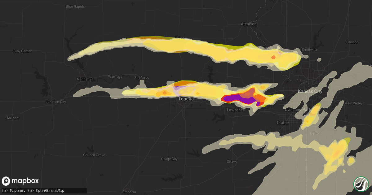
Hail Map in Topeka, KS on October 1, 2014
Get this storm
October 1 map
$229
one time, instant access
Download today. No call, no setup
Keep the $229
Bought the map and want the full workflow? Apply the entire $229 to a subscription within 7 days. None of it is wasted.
Every map, not just this one
This buys you this map. Subscription and you get every map we run, in the markets you choose from a few cities to whole states to nationwide. Plus real-time alerts the moment a storm fires.
Contact data
Name, contact info, occupancy, even credit band for addresses in the footprint. You go from where it hit to who to call.
Become the source they trust
Unlimited branding weather history reports on demand. You already have the documented answer ready for the property owner, and you are the one who showed up with it.
Property data and RoofTrace estimates
Pull up any address you have got, its value and the exact code rules for that jurisdiction, straight from One Click Code. Then RoofTrace estimates the squares, pitch, and roof value, priced the way you price.
Storm reports in Topeka, KS
Topeka, KS
| Date | Description |
|---|---|
| 09/30/201410:15 PM CDT | A local report indicates 1.25 inch wind near 5 NE TOPEKA |
| 09/30/201410:06 PM CDT | Storm spotter estimated hail size |
| 09/30/20148:41 PM CDT | Measured wind gust by asos. |
| 09/30/20148:41 PM CDT | Quarter size hail observed by forecasters on station at topeka nws |
| 09/30/20148:40 PM CDT | 3.5 inch limbs down in sw topeka |
| 09/30/20148:25 PM CDT | A local report indicates 60 MPH wind near 2 SW TOPEKA |
All States Impacted by Hail Map on October 1, 2014
All Cities Impacted by Hail Map on October 1, 2014
- Correctionville, IA
- Anthon, IA
- Clinton, MO
- Butler, MO
- Harvard, NE
- Cairo, NE
- Cedar Rapids, NE
- Saint Paul, NE
- Dannebrog, NE
- Wood River, NE
- Ravenna, NE
- Greeley, NE
- Wolbach, NE
- Shelton, NE
- Elba, NE
- Boelus, NE
- Primrose, NE
- Rockville, NE
- Spalding, NE
- Cole Camp, MO
- Lincoln, MO
- Ionia, MO
- Chandler, OK
- Gothenburg, NE
- Hume, MO
- Foster, MO
- Eldon, MO
- Olean, MO
- Stover, MO
- Versailles, MO
- Gravois Mills, MO
- Barnett, MO
- Maud, OK
- Wewoka, OK
- Hardin, MO
- Warrensburg, MO
- Knob Noster, MO
- Concordia, MO
- Inland, NE
- Hastings, NE
- Juniata, NE
- Holstein, NE
- Roseland, NE
- Kenesaw, NE
- Pleasanton, NE
- Milligan, NE
- Ohiowa, NE
- Coffeyville, KS
- Wann, OK
- S Coffeyville, OK
- Elmer, OK
- Altoona, KS
- Fredonia, KS
- Elk City, KS
- Neodesha, KS
- Byron, NE
- Superior, NE
- Hardy, NE
- Guide Rock, NE
- Deshler, NE
- Ruskin, NE
- Nelson, NE
- Bartlett, KS
- Edna, KS
- Rogers, NE
- Schuyler, NE
- Beloit, KS
- Hunter, KS
- Jamestown, KS
- Concordia, KS
- Osborne, KS
- Tipton, KS
- Lucas, KS
- Simpson, KS
- Arnold, NE
- Stapleton, NE
- Columbia, MO
- Tebbetts, MO
- Jamestown, MO
- Bonnots Mill, MO
- Tipton, MO
- Hartsburg, MO
- Chamois, MO
- Ashland, MO
- Prairie Home, MO
- Holts Summit, MO
- Clarksburg, MO
- California, MO
- Syracuse, MO
- Bunceton, MO
- New Bloomfield, MO
- Centertown, MO
- Jefferson City, MO
- Marshall, MO
- Lawrence, KS
- Perry, KS
- Boley, OK
- Seminole, OK
- Okemah, OK
- Paden, OK
- Davidson, OK
- Electra, TX
- Kansas City, MO
- Atchison, KS
- Platte City, MO
- Fort Leavenworth, KS
- Winchester, KS
- Easton, KS
- Leavenworth, KS
- Blue Mound, KS
- Garnett, KS
- Centerville, KS
- Madison, KS
- Eureka, KS
- El Dorado, KS
- Virgil, KS
- Hamilton, KS
- Yates Center, KS
- Gridley, KS
- Ozawkie, KS
- Linwood, KS
- Bonner Springs, KS
- Rossville, KS
- Tecumseh, KS
- Meriden, KS
- Tonganoxie, KS
- Lecompton, KS
- Oskaloosa, KS
- Topeka, KS
- Silver Lake, KS
- Grantville, KS
- Eustis, NE
- Otterville, MO
- Hughesville, MO
- Boonville, MO
- La Monte, MO
- Pilot Grove, MO
- Sedalia, MO
- Smithton, MO
- Calhoun, MO
- Windsor, MO
- Warsaw, MO
- Manhattan, KS
- Westmoreland, KS
- Skiatook, OK
- Harrisonville, MO
- Pleasant Hill, MO
- Paola, KS
- Konawa, OK
- Dodge, NE
- Wellston, OK
- Thayer, KS
- Cherryvale, KS
- Grandview, MO
- Overland Park, KS
- Leawood, KS
- Iola, KS
- Edgerton, KS
- Bronson, KS
- Eudora, KS
- Osawatomie, KS
- Fulton, KS
- Amsterdam, MO
- Overbrook, KS
- Kincaid, KS
- Westphalia, KS
- Uniontown, KS
- Freeman, MO
- Parker, KS
- Adrian, MO
- Neosho Falls, KS
- Mound City, KS
- Colony, KS
- Amoret, MO
- Pleasanton, KS
- Lane, KS
- Buffalo, KS
- Moran, KS
- Greeley, KS
- Peculiar, MO
- Mapleton, KS
- Gardner, KS
- Belton, MO
- Louisburg, KS
- Stilwell, KS
- Ottawa, KS
- La Cygne, KS
- Le Roy, KS
- Baldwin City, KS
- Olathe, KS
- Redfield, KS
- Piqua, KS
- Garden City, MO
- Bucyrus, KS
- Welda, KS
- Prescott, KS
- Drexel, MO
- Wellsville, KS
- Spring Hill, KS
- Archie, MO
- Cleveland, MO
- Holton, KS
- Vernon, TX
- Chillicothe, TX
- Clay Center, KS
- Wakefield, KS
- Pomona, KS
- Quenemo, KS
- Mayetta, KS
- Havensville, KS
- Soldier, KS
- Miami, MO
- Galena, KS
- Riverton, KS
- Baxter Springs, KS
- Columbus, KS
- Lexington, NE
- Bristow, OK
- Sapulpa, OK
- Kellyville, OK
- Whiteman Air Force Base, MO
- Leeton, MO
- Holden, MO
- Blairstown, MO
- Creighton, MO
- Chilhowee, MO
- Atlanta, NE
- Bertrand, NE
- Elwood, NE
- Oxford, NE
- Grandfield, OK
- Green Ridge, MO
- Nowata, OK
- Ramona, OK
- Delaware, OK
- Ochelata, OK
- Bartlesville, OK
- Blackburn, MO
- Oklahoma City, OK
- Mustang, OK
- Tuttle, OK
- Mora, MO
- Pauls Valley, OK
- Elmore City, OK
- Maysville, OK
- Foster, OK
- Colony, OK
- Corn, OK
- Denison, KS
- Valley Falls, KS
- Nortonville, KS
- Red Cloud, NE
- Montrose, MO
- Tecumseh, NE
- Crab Orchard, NE
- Cushing, OK
- Yale, OK
- Morrison, MO
- Linn, MO
- Mokane, MO
- Chickasha, OK
- Gypsum, KS
- Walnut, KS
- Copan, OK
- Pawhuska, OK
- Greensburg, KS
- Bucklin, KS
- Mullinville, KS
- Daykin, NE
- Pawnee, OK
- Bluejacket, OK
- Maple Hill, KS
- Kansas City, KS
- Shawnee, KS
- Basehor, KS
- Paxico, KS
- Humboldt, NE
- Brownville, NE
- Filley, NE
- Auburn, NE
- De Witt, NE
- Pickrell, NE
- Sterling, NE
- Elk Creek, NE
- Cook, NE
- Adams, NE
- Steinauer, NE
- Beatrice, NE
- Johnson, NE
- Depew, OK
- Amherst, NE
- Lamont, OK
- Tonkawa, OK
- Sutherland, NE
- Tryon, NE
- Hoyt, KS
- Vinita, OK
- Harrold, TX
- Swanton, NE
- Western, NE
- Wilber, NE
- Bloomington, NE
- Eddyville, NE
- Sumner, NE
- Miami, OK
- Beaver City, NE
- Hebron, NE
- Republican City, NE
- Bladen, NE
- Naponee, NE
- Blue Hill, NE
- Franklin, NE
- Riverton, NE
- Inavale, NE
- Luther, OK
- Jones, OK
- Dewey, OK
- Minden, NE
- Mcloud, OK
- Harrah, OK
- Meeker, OK
- Blanchard, OK
- Galesburg, KS
- Chanute, KS
- Erie, KS
- Holdenville, OK
- Grenola, KS
- Howard, KS
- Olsburg, KS
- Onaga, KS
- Fairfax, OK
- Cleveland, OK
- Hominy, OK
- Higginsville, MO
- Quapaw, OK
- Carnegie, OK
- Hydro, OK
- Carrollton, MO
- Greenfield, IL
- Miller, NE
- Riverdale, NE
- Braman, OK
- Blackwell, OK
- Sylvester, TX
- Lyndon, KS
- Lebo, KS
- Parsons, KS
- Armstrong, IA
- Farley, MO
- Welch, OK
- Frederick, OK
- Alma, KS
- Wamego, KS
- Anselmo, NE
- Luray, KS
- Glen Elder, KS
- Glasco, KS
- Waldo, KS
- Sutton, NE
- Shawnee, OK
- Henderson, NE
- Independence, KS
- Mullen, NE
- Stratford, OK
- Choctaw, OK
- Sullivan, MO
- Chetopa, KS
- Oswego, KS
- Tecumseh, OK
- Macomb, OK
- Newcastle, OK
- Norman, OK
- Sibley, MO
- Buckner, MO
- Medora, IL
- Carlinville, IL
- Chesterfield, IL
- Rockbridge, IL
- Hettick, IL
- Rush Springs, OK
- Richmond, MO
- Orrick, MO
- Camden, MO
- Stroud, OK
- Carney, OK
- Saronville, NE
- Clay Center, NE
- Glenvil, NE
- Heartwell, NE
- Joplin, MO
- Oak, NE
- Amber, OK
- Pocasset, OK
- Morgan, MN
- Ringling, OK
- York, NE
- Wanette, OK
- Lexington, OK
- Faxon, OK
- Walters, OK
- Waverly, KS
- Headrick, OK
- Prague, OK
- Sweet Springs, MO
- Cozad, NE
- Saint Paul, KS
- Byars, OK
- Asher, OK
- Huntsville, MO
- Higbee, MO
- Jennings, OK
- Maramec, OK
- Davis, OK
- Wynnewood, OK
- Phillipsburg, KS
- Agra, KS
- Lawrence, NE
- Moberly, MO
- Weston, MO
- Norborne, MO
- Abilene, KS
- Netawaka, KS
- Wetmore, KS
- Whiting, KS
- Perry, MO
- Binger, OK
- Lookeba, OK
- Earlsboro, OK
- Hennepin, OK
- Liberty, IL
- Plainville, IL
- Aurora, NE
- Lockwood, MO
- McLouth, KS
- Lenapah, OK
- Fontana, KS
- Hunter, OK
- Redwood Falls, MN
- Orleans, NE
- Arapahoe, NE
- Plymouth, NE
- Brady, NE
- Havana, KS
- Mound Valley, KS
- Longton, KS
- Sedan, KS
- Dennis, KS
- Beggs, OK
- Madison, MO
- Holdrege, NE
- Liberty, KS
- Scammon, KS
- Riley, KS
- Saint George, KS
- Longford, KS
- Ada, OK
- Doniphan, NE
- Verden, OK
- De Witt, MO
- Newkirk, OK
- Burlington, KS
- Henrietta, TX
- Valentine, NE
- Thedford, NE
- Cache, OK
- De Soto, KS
- Saint Marys, KS
- McFarland, KS
- Drumright, OK
- Arcadia, OK
- Carthage, MO
- Sand Springs, OK
- Delia, KS
- Lansing, KS
- Smithville, MO
- Waldron, MO
- Weir, KS
- Jasper, MO
- Oronogo, MO
- Webb City, MO
- Carl Junction, MO
- Asbury, MO
- Altamont, KS
- Pittsburg, KS
- Rich Hill, MO
- Okmulgee, OK
- Greenfield, MO
- Williamsburg, KS
- Newalla, OK
- Santa Fe, MO
- Stoutsville, MO
- Cody, NE
- Rosalia, KS
- Agra, OK
- Tryon, OK
- Fort Stockton, TX
- Barnsdall, OK
- Independence, MO
- Mason City, NE
- Malta Bend, MO
- Richmond, KS
- Rantoul, KS
- North Bend, NE
- Phillips, NE
- Melvern, KS
- Gerald, MO
- Rosebud, MO
- Davenport, OK
- Anson, TX
- Eldred, IL
- Carrollton, IL
- Slater, MO
- Loveland, OK
- Anadarko, OK
- Mission, KS
- Urich, MO
- Alma, MO
- Hazard, NE
- Emmett, KS
- Excelsior Springs, MO
- Lees Summit, MO
- Kingsville, MO
- Raymore, MO
- Florence, MO
- Rocky Mount, MO
- Henrietta, MO
- Eugene, MO
- Greenwood, MO
- East Lynne, MO
- Leon, KS
- Latham, MO
- Centerview, MO
- Liberty, MO
- Lohman, MO
- La Harpe, KS
- Lone Jack, MO
- Blue Springs, MO
- Prairie Village, KS
- Strasburg, MO
- New Century, KS
- Deepwater, MO
- Houstonia, MO
- Lenexa, KS
- Russellville, MO
- Crowell, TX
- Fort Cobb, OK
- Apache, OK
- Fenton, MO
- Princeton, KS
- Cassoday, KS
- Lawton, OK
- Horton, KS
- Wynona, OK
- Sedgwick, CO
- Caney, KS
- Tyro, KS
- Sparks, OK
- Brunswick, MO
- Springer, OK
- Shickley, NE
- Ong, NE
- Eldorado, OK
- Gibbon, NE


