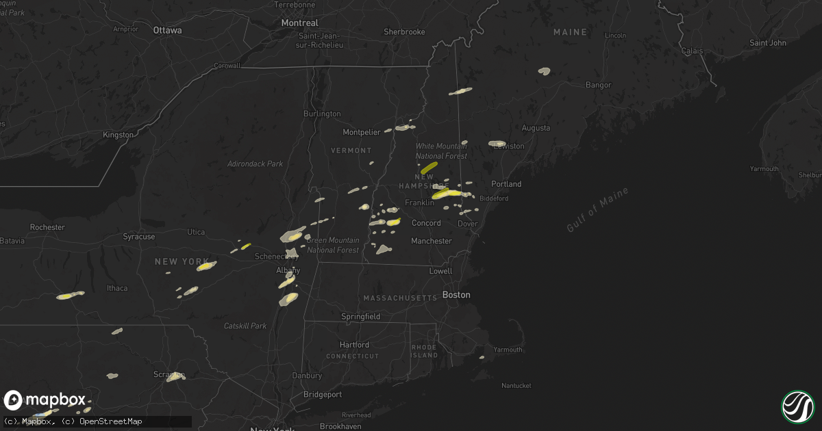
Hail Map in Vermont on September 15, 2021
Get this storm
September 15 map
$229
one time, instant access
Download today. No call, no setup
Keep the $229
Bought the map and want the full workflow? Apply the entire $229 to a subscription within 7 days. None of it is wasted.
Every map, not just this one
This buys you this map. Subscription and you get every map we run, in the markets you choose from a few cities to whole states to nationwide. Plus real-time alerts the moment a storm fires.
Contact data
Name, contact info, occupancy, even credit band for addresses in the footprint. You go from where it hit to who to call.
Become the source they trust
Unlimited branding weather history reports on demand. You already have the documented answer ready for the property owner, and you are the one who showed up with it.
Property data and RoofTrace estimates
Pull up any address you have got, its value and the exact code rules for that jurisdiction, straight from One Click Code. Then RoofTrace estimates the squares, pitch, and roof value, priced the way you price.
Storm reports in Vermont
Vermont
| Date | Description |
|---|---|
| 09/15/20212:12 PM CDT | Law enforcement reports tree down on north rd in peru. Time estimated from radar. |
| 09/15/20212:10 PM CDT | Law enforcement reports tree down near the intersection of main st and south rd in peru. Time estimated from radar |
| 09/15/20212:03 PM CDT | Tree down on powerlines along plains road. |
| 09/15/20212:02 PM CDT | Law enforcement reports tree down near timber trail rd and rt 7a. Time estimated from radar |
| 09/15/20212:02 PM CDT | Law enforcement reports tree down near old west rd and rt 7a. Time estimated from radar. |
| 09/15/20211:41 PM CDT | Trees and powerlines down along us 5. |
| 09/15/20211:39 PM CDT | Trees and powerlines down along us 5. |
| 09/15/20211:22 PM CDT | Trees and powerlines down. |
| 09/15/20211:20 PM CDT | Trees and powerlines down in woodstock. |
| 09/15/20211:09 PM CDT | Trees and powerlines down in bridgewater. |
| 09/15/202112:26 PM CDT | Several trees down in middleton springs. |
| 09/14/202111:07 PM CDT | At 407 PM EDT, a severe thunderstorm was located 7 miles north of Marlow, or 11 miles southeast of Claremont, moving east at 40 mph. HAZARD...60 mph wind gusts and quarter size hail. SOURCE...Radar indicated. IMPACT...Hail damage to vehicles is expected. Expect wind damage to roofs, siding, and trees. Locations impacted include... Concord, Claremont, Franklin, Henniker, New London, Hopkinton, New Boston, Antrim, Canterbury, Greenfield, Hancock, Bradford, Francestown, Bennington, Danbury, Nelson, Walpole, Alstead, Marlow and Sullivan. |
| 09/14/20219:31 PM CDT | At 231 PM EDT, severe thunderstorms were located along a line extending from 8 miles west of Littleton to near Lebanon, moving east at 30 mph. HAZARD...60 mph wind gusts and nickel size hail. SOURCE...Radar indicated. IMPACT...Expect damage to roofs, siding, and trees. Locations impacted include... Laconia, Lebanon, Bethlehem, Lincoln, Plymouth, Meredith, Moultonborough, Grafton, Hanover, Haverhill, Enfield, Canaan, Holderness, Ashland, Danbury, Franconia, Groton, Woodstock, Sandwich and Piermont. |
| 09/14/20219:28 PM CDT | At 226 PM EDT, a severe thunderstorm was located over Greenwich, or 11 miles southwest of Salem, moving east at 25 mph. HAZARD...60 mph wind gusts and quarter size hail. SOURCE...Radar indicated. IMPACT...Hail damage to vehicles is expected. Expect wind damage to roofs, siding, and trees. Locations impacted include... Mechanicville, Hoosick Falls, Arlington, Salem, Manchester, Shaftsbury, Cambridge, Greenwich, Manchester Center, Halfmoon, Lee, White Creek, Easton, Stillwater, North Bennington, Schuylerville, Sunderland, Victory, Schaghticoke and Valley Falls. |
| 09/14/20219:18 PM CDT | At 218 PM EDT, a severe thunderstorm was located 11 miles west of Littleton, moving east at 45 mph. HAZARD...60 mph wind gusts and quarter size hail. SOURCE...Radar indicated. IMPACT...Hail damage to vehicles is expected. Expect wind damage to roofs, siding, and trees. Locations impacted include... Berlin, Littleton, Lancaster, Bethlehem, Franconia, Pinkham Notch, Mount Washington, Carroll, Gorham, Lisbon, Jefferson, Bath, Dalton, Jackson, Dummer, Whitefield, Randolph, Monroe, Lyman and Sugar Hill. |
| 09/14/20219:15 PM CDT | At 215 PM EDT, a severe thunderstorm was located over Dorset, or near Manchester, moving northeast at 45 mph. HAZARD...60 mph wind gusts and half dollar size hail. SOURCE...Radar indicated. IMPACT...Hail damage to vehicles is expected. Expect wind damage to roofs, siding, and trees. Locations impacted include... Salem, Manchester, Dorset, Manchester Center, Porter, Rupert, Sandgate, Peru, Cossayuna, Beartown, Braymer School, Goose Island, Peru Town Center, Adamsville, East Hebron, South Granville, Rexleigh, Tiplady, Barnumville and Eagleville. |
| 09/14/20218:18 PM CDT | At 118 PM EDT, a severe thunderstorm was located near Saratoga Springs, moving northeast at 35 mph. HAZARD...60 mph wind gusts and quarter size hail. SOURCE...Radar indicated. IMPACT...Hail damage to vehicles is expected. Expect wind damage to roofs, siding, and trees. This severe thunderstorm will be near... Greenwich around 130 PM EDT. Salem around 150 PM EDT. Dorset around 210 PM EDT.Other locations impacted by this severe thunderstorm include DeansCorners, Cossayuna, Beartown, Dunham Basin, Center Falls, GooseIsland, Adamsville, Grangerville, North Granville and Northumberland. |
All States Impacted by Hail Map on September 15, 2021
Cities Impacted by Hail Map on September 15, 2021
- Cloudcroft, NM
- White Sands Missile Range, NM
- Kinderhook, NY
- Ghent, NY
- Stottville, NY
- Hudson, NY
- Fort Hancock, TX
- El Paso, TX
- Chester, VT
- Cavendish, VT
- Perkinsville, VT
- Edinburg, ND
- Adams, ND
- Guilford, NY
- Oxford, NY
- Climax, MN
- Buxton, ND
- Washington, NH
- Bradford, NH
- Mentor, MN
- Red Lake Falls, MN
- Julian, PA
- Port Matilda, PA
- Pine Grove, PA
- Jonestown, PA
- Smithsburg, MD
- Hagerstown, MD
- Sabillasville, MD
- Fairplay, MD
- Williamsport, MD
- Falling Waters, WV
- Fosston, MN
- Lengby, MN
- Newport, NH
- Sunapee, NH
- Newry, ME
- Andover, ME
- Salem, NY
- West Rupert, VT
- Dorset, VT
- Arlington, VT
- Bridgewater Corners, VT
- Bridgewater, VT
- Woodstock, VT
- Schuylerville, NY
- Stillwater, NY
- Bellefonte, PA
- Otego, NY
- Unadilla, NY
- Mechanic Falls, ME
- Auburn, ME
- Poland, ME
- Minot, ME
- Monroe, NH
- Littleton, NH
- Lisbon, NH
- Valatie, NY
- Duncannon, PA
- Halifax, PA
- Tower City, PA
- Annville, PA
- State College, PA
- Fertile, MN
- Erskine, MN
- Lewisburg, PA
- Mifflinburg, PA
- Mechanicville, NY
- Troy, NY
- Melrose, NY
- Waterford, NY
- Hillsborough, NH
- Lempster, NH
- Shapleigh, ME
- Park River, ND
- Grafton, ND
- Schodack Landing, NY
- Castleton On Hudson, NY
- Sanbornville, NH
- Wolfeboro, NH
- New Durham, NH
- Edmeston, NY
- West Burlington, NY
- Burlington Flats, NY
- Garrattsville, NY
- New Berlin, NY
- Fly Creek, NY
- Cooperstown, NY
- Hartwick, NY
- Mount Vision, NY
- Charlestown, NH
- Alamogordo, NM
- Selkirk, NY
- Coeymans Hollow, NY
- Coeymans, NY
- Hannacroix, NY
- Nassau, NY
- West Coxsackie, NY
- Ravena, NY
- Gilford, NH
- Moultonborough, NH
- Mirror Lake, NH
- Meredith, NH
- Newbury, NH
- Spofford, NH
- Keene, NH
- Bradford, NY
- Watkins Glen, NY
- Beaver Dams, NY
- Saratoga Springs, NY
- Greenwich, NY
- Loganton, PA
- Cossayuna, NY
- East Grand Forks, MN
- Manvel, ND
- Thornton, NH
- Bagley, MN
- East Dorset, VT
- Sharpsburg, MD
- Funkstown, MD
- Cascade, MD
- Waynesboro, PA
- Martinsburg, WV
- Shepherdstown, WV
- Keedysville, MD
- Boonsboro, MD
- Fort Plain, NY
- Bath, NY
- Savona, NY
- Center Barnstead, NH
- Alton, NH
- Centre Hall, PA
- Howard, PA
- Winger, MN
- Crookston, MN
- Spring Mills, PA
- Madisonburg, PA
- Muncy Valley, PA
- Warren, MN
- Alton Bay, NH
- Mahnomen, MN
- Shevlin, MN
- Alfred, ME
- Marlow, NH
- Alstead, NH
- Palatine Bridge, NY
- Fultonville, NY
- Fonda, NY
- Sprakers, NY
- Canisteo, NY
- Hammondsport, NY
- Milan, NH
- South Plymouth, NY
- Norwich, NY
- New Columbia, PA
- Acton, ME
- Union, NH
- Milton Mills, NH
- Gilmanton Iron Works, NH
- Belmont, NH
- Gilmanton, NH
- Goshen, NH
- Strafford, VT
- Tunbridge, VT
- Lykens, PA
- Hegins, PA
- Spring Glen, PA
- Abingdon, MD
- East Ryegate, VT
- Groton, VT
- Barnet, VT
- Chatham, NY
- Stuyvesant Falls, NY
- Athens, NY
- Stuyvesant, NY
- Lake Ariel, PA
- Moosic, PA
- Pittston, PA
- Scranton, PA
- Sterling, PA
- Moscow, PA
- Lebanon, ME
- Rochester, NH
- Berwick, ME
- Bethlehem, NH
- Troy, NH
- Marlborough, NH
- Dublin, NH
- Swanzey, NH
- Fryeburg, ME
- Lovell, ME
- Eagles Mere, PA
- Westmoreland, NH
- Springfield, VT
- Proctorsville, VT
- Albany, NY
- Rensselaer, NY
- Glenmont, NY
- East Schodack, NY
- East Greenbush, NY
- Stoddard, NH
- South Acworth, NH
- Buskirk, NY
- Valley Falls, NY
- Johnsonville, NY
- Milan, PA
- Ulster, PA
- Sayre, PA
- Athens, PA
- Falmouth, MA
- East Falmouth, MA
- North Falmouth, MA
- Oxford, ME
- Canajoharie, NY
- Beltrami, MN
- Cambridge, NY
- Argyle, NY
- Ballston Spa, NY
- Acworth, NH
- Plymouth, VT
- Wells, ME
- North Berwick, ME
- Sanford, ME
- Mount Upton, NY
- Klingerstown, PA
- Dornsife, PA
- Sacramento, PA
- Bainbridge, NY
- Wynantskill, NY
- Center Tuftonboro, NH
- Ossipee, NH
- East Wakefield, NH
- South New Berlin, NY
- Walpole, NH
- Wells, VT
- Middletown Springs, VT
- North Granville, NY
- Poultney, VT
- Granville, NY
- Middle Granville, NY
- Hampton, NY
- Claremont, NH
- Catskill, NY
- Leeds, NY
- Coxsackie, NY
- Schaghticoke, NY
- Cohoes, NY
- Clifton Park, NY
- Rexford, NY
- Latham, NY
- Farmington, NH
- Milton, NH
- Lemont, PA
- University Park, PA
- Boalsburg, PA
- Rebersburg, PA
- Malden Bridge, NY
- Forest Hill, MD
- Bel Air, MD
- Parsonsfield, ME
- Limerick, ME
- West Newfield, ME
- Solway, MN
- Gilby, ND
- Athens, ME
- Solon, ME
- Harmony, ME
- Skowhegan, ME
- Errol, NH
- Williamstown, PA
- Aberdeen, MD
- Aberdeen Proving Ground, MD
- Perryman, MD
- Tulsa, OK
- Jenks, OK
- Nielsville, MN
- Center Sandwich, NH
- Holderness, NH
- Campton, NH
- North Sandwich, NH


