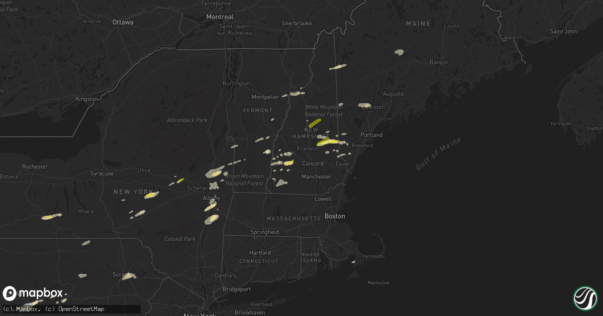
Hail Map in New Hampshire on September 15, 2021
Get this storm
September 15 map
$229
one time, instant access
Download today. No call, no setup
Keep the $229
Bought the map and want the full workflow? Apply the entire $229 to a subscription within 7 days. None of it is wasted.
Every map, not just this one
This buys you this map. Subscription and you get every map we run, in the markets you choose from a few cities to whole states to nationwide. Plus real-time alerts the moment a storm fires.
Contact data
Name, contact info, occupancy, even credit band for addresses in the footprint. You go from where it hit to who to call.
Become the source they trust
Unlimited branding weather history reports on demand. You already have the documented answer ready for the property owner, and you are the one who showed up with it.
Property data and RoofTrace estimates
Pull up any address you have got, its value and the exact code rules for that jurisdiction, straight from One Click Code. Then RoofTrace estimates the squares, pitch, and roof value, priced the way you price.
Storm reports in New Hampshire
New Hampshire
| Date | Description |
|---|---|
| 09/15/20215:04 PM CDT | 1 tree down near town green. Time estimated by radar. |
| 09/15/20214:40 PM CDT | Trees down in the town of sharon. One tree blocking nh hwy 123. Time estimated by radar. |
| 09/15/20214:25 PM CDT | A local report indicates 1.25 inch wind near WAKEFIELD |
| 09/15/20214:22 PM CDT | Trees down south of peterborough along us hwy 202. Small hail also fell. Time estimated by radar. |
| 09/15/20214:12 PM CDT | Trees down on mcveagh rd. Diameter of trees up to 7 inches. Time estimated based on radar. |
| 09/15/20214:12 PM CDT | Leaves shredded from hail. |
| 09/15/20214:09 PM CDT | Time estimated based on radar. |
| 09/15/20213:30 PM CDT | A local report indicates 1.00 inch wind near 2 SSW BRADFORD |
| 09/15/20213:20 PM CDT | A local report indicates 1.25 inch wind near WASHINGTON |
| 09/15/20213:18 PM CDT | A local report indicates 1.00 inch wind near 1 N NORTH SANDWICH |
| 09/15/20213:15 PM CDT | Trees and wires down on nh 10. Delayed report. Time estimated from radar. |
| 09/15/20213:10 PM CDT | Trees down across claremont. Time estimated based on radar. |
| 09/15/20213:10 PM CDT | Numerous trees down north of walpole. Penny size hail also reported. |
| 09/15/20213:08 PM CDT | Trees down across unity. Time estimated based on radar. |
| 09/15/20212:45 PM CDT | One tree and power line down on upper mad river rd. |
| 09/15/20212:20 PM CDT | Trees down near koa campground off highway 175 south of woodstock. |
| 09/15/20212:20 PM CDT | Corrects previous tstm wnd dmg report from claremont. Trees down across claremont. Time estimated based on radar. |
| 09/15/20212:15 PM CDT | Numerous trees down across berlin. Time estimated based on radar. |
| 09/15/20211:43 PM CDT | Numerous trees down across lancaster. Time estimated based on radar. |
| 09/15/20211:41 PM CDT | Numerous trees down across littleton. Time estimated based on radar. |
| 09/15/20211:40 PM CDT | A local report indicates 1.25 inch wind near 7 SE ERROL |
| 09/14/202110:02 PM CDT | At 302 PM EDT, a severe thunderstorm was located over Weathersfield, moving east at 40 mph. HAZARD...Ping pong ball size hail and 60 mph wind gusts. SOURCE...Radar indicated. IMPACT...People and animals outdoors will be injured. Expect hail damage to roofs, siding, windows, and vehicles. Expect wind damage to trees and powerlines. Locations impacted include... Chester, Windsor, Cavendish, Baltimore, Perkinsville Village, Weathersfield, Ascutney, West Windsor, Springfield, Perkinsville, Whitesville, Cavendish Center, Weathersfield Bow, Amsden, Brownsville, Ascutney State Park, North Springfield Lake Recreation Area, North Springfield, Downers and Wilgus State Park. |
| 09/14/20219:33 PM CDT | At 232 PM EDT, a severe thunderstorm was located near Errol, or 15 miles north of Berlin, moving northeast at 50 mph. HAZARD...Ping pong ball size hail and 60 mph wind gusts. SOURCE...Radar indicated. IMPACT...People and animals outdoors will be injured. Expect hail damage to roofs, siding, windows, and vehicles. Expect wind damage to roofs, siding, and trees. Locations impacted include... Rangeley, Errol, Weld, Dallas Plantation, Dummer, Magalloway Plantation, Lang, Adamstown, Richardsontown, South Arm, Sandy River Plantation, Upton, Rangeley Plantation, Wentworth Location, Lincoln Plantation, Madrid, Redington, Coplin Plantation, Lower Cupsuptic and Davis. |
| 09/14/20219:32 PM CDT | At 230 PM EDT, a severe thunderstorm was located over West Fairlee, moving east at 30 mph. HAZARD...60 mph wind gusts and quarter size hail. SOURCE...Radar indicated. IMPACT...Minor hail damage to vehicles is possible. Expect wind damage to trees and powerlines. Locations impacted include... West Fairlee, Newbury Village, Bradford, Vershire, Fairlee, Strafford, Thetford, Newbury, Corinth, South Vershire, Bradford Center, West Fairlee Center, Ely, Post Mills and South Newbury. |
| 09/14/20219:07 PM CDT | At 207 PM EDT, a severe thunderstorm was located over Bridgewater Corners, moving east at 25 mph. HAZARD...60 mph wind gusts and quarter size hail. SOURCE...Radar indicated. IMPACT...Minor hail damage to vehicles is possible. Expect wind damage to trees and powerlines. Locations impacted include... White River Junction, Woodstock, Hartland Four Corners, Woodstock Village, Quechee, Plymouth, Hartland, Bridgewater, Hartford, Pomfret, Norwich, Reading, Killington, West Windsor, Plymouth Union, Queechee State Park, South Sherburne, North Hartland Dam Recreation Area, West Woodstock and South Woodstock. |
All States Impacted by Hail Map on September 15, 2021
Cities Impacted by Hail Map on September 15, 2021
- Cloudcroft, NM
- White Sands Missile Range, NM
- Kinderhook, NY
- Ghent, NY
- Stottville, NY
- Hudson, NY
- Fort Hancock, TX
- El Paso, TX
- Chester, VT
- Cavendish, VT
- Perkinsville, VT
- Edinburg, ND
- Adams, ND
- Guilford, NY
- Oxford, NY
- Climax, MN
- Buxton, ND
- Washington, NH
- Bradford, NH
- Mentor, MN
- Red Lake Falls, MN
- Julian, PA
- Port Matilda, PA
- Pine Grove, PA
- Jonestown, PA
- Smithsburg, MD
- Hagerstown, MD
- Sabillasville, MD
- Fairplay, MD
- Williamsport, MD
- Falling Waters, WV
- Fosston, MN
- Lengby, MN
- Newport, NH
- Sunapee, NH
- Newry, ME
- Andover, ME
- Salem, NY
- West Rupert, VT
- Dorset, VT
- Arlington, VT
- Bridgewater Corners, VT
- Bridgewater, VT
- Woodstock, VT
- Schuylerville, NY
- Stillwater, NY
- Bellefonte, PA
- Otego, NY
- Unadilla, NY
- Mechanic Falls, ME
- Auburn, ME
- Poland, ME
- Minot, ME
- Monroe, NH
- Littleton, NH
- Lisbon, NH
- Valatie, NY
- Duncannon, PA
- Halifax, PA
- Tower City, PA
- Annville, PA
- State College, PA
- Fertile, MN
- Erskine, MN
- Lewisburg, PA
- Mifflinburg, PA
- Mechanicville, NY
- Troy, NY
- Melrose, NY
- Waterford, NY
- Hillsborough, NH
- Lempster, NH
- Shapleigh, ME
- Park River, ND
- Grafton, ND
- Schodack Landing, NY
- Castleton On Hudson, NY
- Sanbornville, NH
- Wolfeboro, NH
- New Durham, NH
- Edmeston, NY
- West Burlington, NY
- Burlington Flats, NY
- Garrattsville, NY
- New Berlin, NY
- Fly Creek, NY
- Cooperstown, NY
- Hartwick, NY
- Mount Vision, NY
- Charlestown, NH
- Alamogordo, NM
- Selkirk, NY
- Coeymans Hollow, NY
- Coeymans, NY
- Hannacroix, NY
- Nassau, NY
- West Coxsackie, NY
- Ravena, NY
- Gilford, NH
- Moultonborough, NH
- Mirror Lake, NH
- Meredith, NH
- Newbury, NH
- Spofford, NH
- Keene, NH
- Bradford, NY
- Watkins Glen, NY
- Beaver Dams, NY
- Saratoga Springs, NY
- Greenwich, NY
- Loganton, PA
- Cossayuna, NY
- East Grand Forks, MN
- Manvel, ND
- Thornton, NH
- Bagley, MN
- East Dorset, VT
- Sharpsburg, MD
- Funkstown, MD
- Cascade, MD
- Waynesboro, PA
- Martinsburg, WV
- Shepherdstown, WV
- Keedysville, MD
- Boonsboro, MD
- Fort Plain, NY
- Bath, NY
- Savona, NY
- Center Barnstead, NH
- Alton, NH
- Centre Hall, PA
- Howard, PA
- Winger, MN
- Crookston, MN
- Spring Mills, PA
- Madisonburg, PA
- Muncy Valley, PA
- Warren, MN
- Alton Bay, NH
- Mahnomen, MN
- Shevlin, MN
- Alfred, ME
- Marlow, NH
- Alstead, NH
- Palatine Bridge, NY
- Fultonville, NY
- Fonda, NY
- Sprakers, NY
- Canisteo, NY
- Hammondsport, NY
- Milan, NH
- South Plymouth, NY
- Norwich, NY
- New Columbia, PA
- Acton, ME
- Union, NH
- Milton Mills, NH
- Gilmanton Iron Works, NH
- Belmont, NH
- Gilmanton, NH
- Goshen, NH
- Strafford, VT
- Tunbridge, VT
- Lykens, PA
- Hegins, PA
- Spring Glen, PA
- Abingdon, MD
- East Ryegate, VT
- Groton, VT
- Barnet, VT
- Chatham, NY
- Stuyvesant Falls, NY
- Athens, NY
- Stuyvesant, NY
- Lake Ariel, PA
- Moosic, PA
- Pittston, PA
- Scranton, PA
- Sterling, PA
- Moscow, PA
- Lebanon, ME
- Rochester, NH
- Berwick, ME
- Bethlehem, NH
- Troy, NH
- Marlborough, NH
- Dublin, NH
- Swanzey, NH
- Fryeburg, ME
- Lovell, ME
- Eagles Mere, PA
- Westmoreland, NH
- Springfield, VT
- Proctorsville, VT
- Albany, NY
- Rensselaer, NY
- Glenmont, NY
- East Schodack, NY
- East Greenbush, NY
- Stoddard, NH
- South Acworth, NH
- Buskirk, NY
- Valley Falls, NY
- Johnsonville, NY
- Milan, PA
- Ulster, PA
- Sayre, PA
- Athens, PA
- Falmouth, MA
- East Falmouth, MA
- North Falmouth, MA
- Oxford, ME
- Canajoharie, NY
- Beltrami, MN
- Cambridge, NY
- Argyle, NY
- Ballston Spa, NY
- Acworth, NH
- Plymouth, VT
- Wells, ME
- North Berwick, ME
- Sanford, ME
- Mount Upton, NY
- Klingerstown, PA
- Dornsife, PA
- Sacramento, PA
- Bainbridge, NY
- Wynantskill, NY
- Center Tuftonboro, NH
- Ossipee, NH
- East Wakefield, NH
- South New Berlin, NY
- Walpole, NH
- Wells, VT
- Middletown Springs, VT
- North Granville, NY
- Poultney, VT
- Granville, NY
- Middle Granville, NY
- Hampton, NY
- Claremont, NH
- Catskill, NY
- Leeds, NY
- Coxsackie, NY
- Schaghticoke, NY
- Cohoes, NY
- Clifton Park, NY
- Rexford, NY
- Latham, NY
- Farmington, NH
- Milton, NH
- Lemont, PA
- University Park, PA
- Boalsburg, PA
- Rebersburg, PA
- Malden Bridge, NY
- Forest Hill, MD
- Bel Air, MD
- Parsonsfield, ME
- Limerick, ME
- West Newfield, ME
- Solway, MN
- Gilby, ND
- Athens, ME
- Solon, ME
- Harmony, ME
- Skowhegan, ME
- Errol, NH
- Williamstown, PA
- Aberdeen, MD
- Aberdeen Proving Ground, MD
- Perryman, MD
- Tulsa, OK
- Jenks, OK
- Nielsville, MN
- Center Sandwich, NH
- Holderness, NH
- Campton, NH
- North Sandwich, NH


