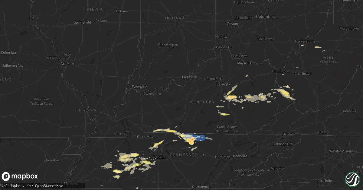
Hail Map in Kentucky on September 5, 2025
Get this storm
September 5 map
$229
one time, instant access
Download today. No call, no setup
Keep the $229
Bought the map and want the full workflow? Apply the entire $229 to a subscription within 7 days. None of it is wasted.
Every map, not just this one
This buys you this map. Subscription and you get every map we run, in the markets you choose from a few cities to whole states to nationwide. Plus real-time alerts the moment a storm fires.
Contact data
Name, contact info, occupancy, even credit band for addresses in the footprint. You go from where it hit to who to call.
Become the source they trust
Unlimited branding weather history reports on demand. You already have the documented answer ready for the property owner, and you are the one who showed up with it.
Property data and RoofTrace estimates
Pull up any address you have got, its value and the exact code rules for that jurisdiction, straight from One Click Code. Then RoofTrace estimates the squares, pitch, and roof value, priced the way you price.
Storm reports in Kentucky
Kentucky
| Date | Description |
|---|---|
| 09/05/20256:35 PM CDT | Multiple pictures on social media of measured quarter-sized hail in shopville... Ky. Time estimated via radar. |
| 09/05/20256:30 PM CDT | Magoffin county dispatch reports a tree blocking south river road near owens cemetery and oakley creek. The tree was down on the stretch of river road that parallels th |
| 09/05/20256:05 PM CDT | Dispatch reported a tree down on a power line resulting in a power outage. |
| 09/05/20256:03 PM CDT | Martin county dispatch reported a downed tree blocking the road in the 6300 block of beauty road/ky-40. Time estimated via radar. |
| 09/05/20255:51 PM CDT | Lee county 911 relayed a report of a downed tree at mile marker 4 from the storms that occurred before 8pm last night. Time estimated via radar. |
| 09/05/20255:45 PM CDT | Wolfe county dispatch received a delayed report this morning of downed trees in a holler blocking blue balk road. Multiple storms moved through this area... But the str |
| 09/05/20255:40 PM CDT | Large tree down on salem rd... Mostly blocking the road. Off duty officer tried to move but was unable. |
| 09/05/20255:36 PM CDT | Martin county dispatch reports a downed tree blocking the road at the intersection of rock house road and lower wolf branch road. Time estimated via radar. Stronger-wor |
| 09/05/20255:18 PM CDT | Tree down on power line at the intersection of ky hwy 11 and ky highway 715. |
| 09/05/20255:12 PM CDT | Report of large tree down on orndorff mill rd. |
| 09/05/20255:04 PM CDT | Picture on social media of a large downed tree blocking ky-1092 between flatgap and drake fork road. Time estimated via radar. |
| 09/04/202510:30 PM CDT | Magoffin county dispatch received a delayed report earlier this morning of large tree branches downed and blocking lakeville road near the intersection with bear branch |
| 09/04/202510:08 PM CDT | Social media report of a downed tree at the vancleve park and ride immediately after the exit ramp from ky-15. Time estimated via radar. |
| 09/04/202510:07 PM CDT | Off-duty nws employee relayed a report of a down tree near the 6000 block of ky-1812. Time estimated from radar. |
| 09/04/202510:06 PM CDT | Social media report of downed trees one mile south of the wolfe/breathitt county line on ky-15. Report corroborated with a traffic slowdown on online gps software. Time |
| 09/04/202510:01 PM CDT | Social media report of a dumpster that was tossed/flipped from the wind at the bethany christian school. Time estimated via radar. |
| 09/04/202510:00 PM CDT | Resends previous tstm wnd dmg report from bethany due to iris error message. Social media report of a large tree down on a fence on bethany school lane in wolfe county. |
| 09/04/20259:50 PM CDT | Lee county 911 relayed a report of a downed tree in the 200 block of gilliam road. Time estimated via radar. |
| 09/04/20259:42 PM CDT | Lee county 911 relayed a report of downed trees along fairgrounds ridge road near the three forks regional jail. Time estimated via radar. |
| 09/04/20259:01 PM CDT | Video on social media of hail coming down near the intersection of walton road and nolan road. Largest stones appear to be quarter sized... With more widespread smaller |
| 09/04/20258:42 PM CDT | Magoffin county dispatch reports a downed tree blocking may branch road just off of highway 460. Time estimated via radar. |
| 09/04/20258:40 PM CDT | Ping pong size hail. |
| 09/04/20257:30 PM CDT | Report of trees down on three forks rd. And boone trail rd. |
All States Impacted by Hail Map on September 5, 2025
Cities Impacted by Hail Map on September 5, 2025
- Holladay, TN
- Jackson, TN
- Waverly, TN
- Finger, TN
- Beech Bluff, TN
- Scotts Hill, TN
- Decaturville, TN
- Adamsville, TN
- Bethel Springs, TN
- Russellville, KY
- Adairville, KY
- Huron, TN
- Middleton, TN
- Reagan, TN
- Luray, TN
- Morris Chapel, TN
- Milledgeville, TN
- Enville, TN
- Lexington, TN
- Jacks Creek, TN
- Sardis, TN
- Olmstead, KY
- Linden, TN
- Allensville, KY
- Franklin, KY
- Parsons, TN
- Centerville, TN
- Paintsville, KY
- River, KY
- Scottsville, KY
- Lobelville, TN
- Duck River, TN
- Lyles, TN
- Primm Springs, TN
- Williamsport, TN
- Clifton, TN
- Belleville, WV
- Louisa, KY
- McKee, KY
- Inez, KY
- Waynesboro, TN
- Decatur, TX
- Washington, WV
- Mineral Wells, WV
- Rhome, TX
- Crum, WV
- Fort Gay, WV
- Dunlow, WV
- Tomahawk, KY
- Adolphus, KY
- Santa Fe, TN
- Harts, WV
- Krum, TX
- Ponder, TX
- Kermit, WV
- Warfield, KY
- Campton, KY
- Salyersville, KY
- Lovely, KY
- Searchlight, NV
- Portland, TN
- Lenore, WV
- Williamson, WV
- Dingess, WV
- Jackson, KY
- Vancleve, KY
- Somerset, KY
- Science Hill, KY
- Chapmanville, WV
- Mount Pleasant, TN
- Hampshire, TN
- Eubank, KY
- Westmoreland, TN
- Pioche, NV
- Columbia, TN
- Hagerhill, KY
- Justin, TX
- Sanger, TX
- Denton, TX
- Argyle, TX
- Aubrey, TX
- Lafayette, TN
- Caliente, NV
- Delbarton, WV
- Ulysses, KY
- Hartsville, TN
- Valley View, TX
- Pilot Point, TX
- Tutor Key, KY
- Castalian Springs, TN
- Gallatin, TN
- Pecks Mill, WV
- Logan, WV
- Royalton, KY
- Macfarlan, WV
- Harrisville, WV
- Smithville, WV
- Rousseau, KY
- East Point, KY
- Dixon Springs, TN
- Little Elm, TX
- Red Boiling Springs, TN
- Moss, TN
- Whitleyville, TN
- Prosper, TX
- Frisco, TX
- Celina, TX
- Tioga, TX
- Gunter, TX
- Mckinney, TX
- Bethpage, TN
- Rome, GA
- Taylorsville, GA
- Gunlock, KY
- Auxier, KY
- Pleasant Shade, TN
- Collinsville, TX
- Melissa, TX
- Howe, TX
- Celina, TN
- Gainesboro, TN
- Hilham, TN
- White Bluff, TN
- Ashland City, TN
- Richmond, KY
- Carthage, TN
- Only, TN
- David, KY
- Nashville, TN
- Kingston Springs, TN
- Pilgrim, KY
- Belfry, KY
- Beauty, KY
- Anna Maria, FL
- Hurricane Mills, TN
- Anna, TX
- Sherman, TX
- Van Alstyne, TX
- Allons, TN
- Monroe, TN
- Byrdstown, TN
- Livingston, TN
- Granville, TN
- McEwen, TN
- Joelton, TN
- Nunnelly, TN
- Hollow Rock, TN
- Huntingdon, TN
- Winchester, KY
- Pegram, TN
- Bays, KY
- Bradenton Beach, FL
- Prestonsburg, KY
- Hueysville, KY
- Langley, KY
- Lavalette, WV
- Huntington, WV
- Whites Creek, TN
- Goodlettsville, TN
- Matewan, WV
- Bruceton, TN
- Buena Vista, TN
- Denison, TX
- Whitewright, TX
- Bells, TX
- Tom Bean, TX
- Ravenna, TX
- Savoy, TX
- Hendrix, OK
- Bonham, TX
- Blue Ridge, TX
- Trenton, TX
- Ector, TX
- Yuma, TN
- Westport, TN
- Paint Lick, KY
- Camden, TN
- Jamestown, TN
- Berea, KY
- Lancaster, KY
- Ivanhoe, TX
- Randolph, TX
- Leonard, TX
- Ladonia, TX
- Dodd City, TX
- Wolfe City, TX
- Bailey, TX
- Waynesburg, KY
- Winfield, WV
- Poca, WV
- Red House, WV
- Irvine, KY
- New Johnsonville, TN
- Sugar Tree, TN
- White House, TN
- Hustonville, KY
- Middleburg, KY
- Wharncliffe, WV
- Gilbert, WV
- Waco, KY
- Bennington, OK
- Bokchito, OK
- Telephone, TX
- Sumner, TX
- Windom, TX
- Brookston, TX
- Honey Grove, TX
- Baxter, TN
- Silver Point, TN
- Big Springs, WV
- Kings Mountain, KY
- Auburn, WV
- Bloomington Springs, TN
- Baisden, WV
- Stanford, KY
- Mount Sterling, KY
- Owingsville, KY
- Hillsboro, KY
- Cookeville, TN
- Glenville, WV
- Coxs Mills, WV
- Buffalo Valley, TN
- Crab Orchard, KY
- Arthur City, TX
- Alvord, TX
- Brodhead, KY
- Sandgap, KY
- Ravenna, KY
- Thompsons Station, TN
- Van Lear, KY
- Boswell, OK
- Hugo, OK
- Boons Camp, KY
- Beattyville, KY
- Cooper, TX
- Powderly, TX
- Paris, TX
- Grant, OK
- Stanton, KY
- Rogers, KY
- Slade, KY
- Sparta, TN
- Vincent, KY
- Hendersonville, TN
- Fort Towson, OK
- Sawyer, OK
- Zoe, KY
- Hestand, KY
- Hohenwald, TN
- Spring Hill, TN
- Cove, AR
- Wickes, AR
- Bon Aqua, TN
- Gillham, AR
- Tyner, KY
- Wayne, WV
- De Queen, AR
- Booneville, KY
- Valliant, OK
- Lockesburg, AR
- Vandervoort, AR
- Grannis, AR
- Wildersville, TN
- Dierks, AR
- Clayhole, KY
- Lake Dallas, TX
- Lewisville, TX
- The Colony, TX
- Carrollton, TX
- Coppell, TX
- Grapevine, TX
- Flower Mound, TX
- Barboursville, WV
- Newhope, AR
- Langley, AR
- Dallas, TX
- Overton, NV
- Plano, TX
- Balch Springs, TX
- Nashville, AR
- Mesquite, TX
- Florence, AL
- Iron City, TN
- Sunnyvale, TX
- Forney, TX
- Terrell, TX
- Chauncey, WV
- Omar, WV
- Killen, AL
- Lewisville, AR
- Garland City, AR
- Lexington, AL
- Rogersville, AL
- Amargosa Valley, NV
- Willow Beach, AZ
- Oliver Springs, TN
- Indian Springs, NV
- Pahrump, NV
- Cotton Valley, LA
- Sarepta, LA
- Franklin, TN
- Plain Dealing, LA
- Oakfield, TN
- Medina, TN
- Eugene, OR
- Cottage Grove, OR
- Creswell, OR
- North Las Vegas, NV
- Las Vegas, NV
- Meadview, AZ
- Kingman, AZ
- Dickson, TN
- Summertown, TN
- Peach Springs, AZ
- Dolan Springs, AZ


