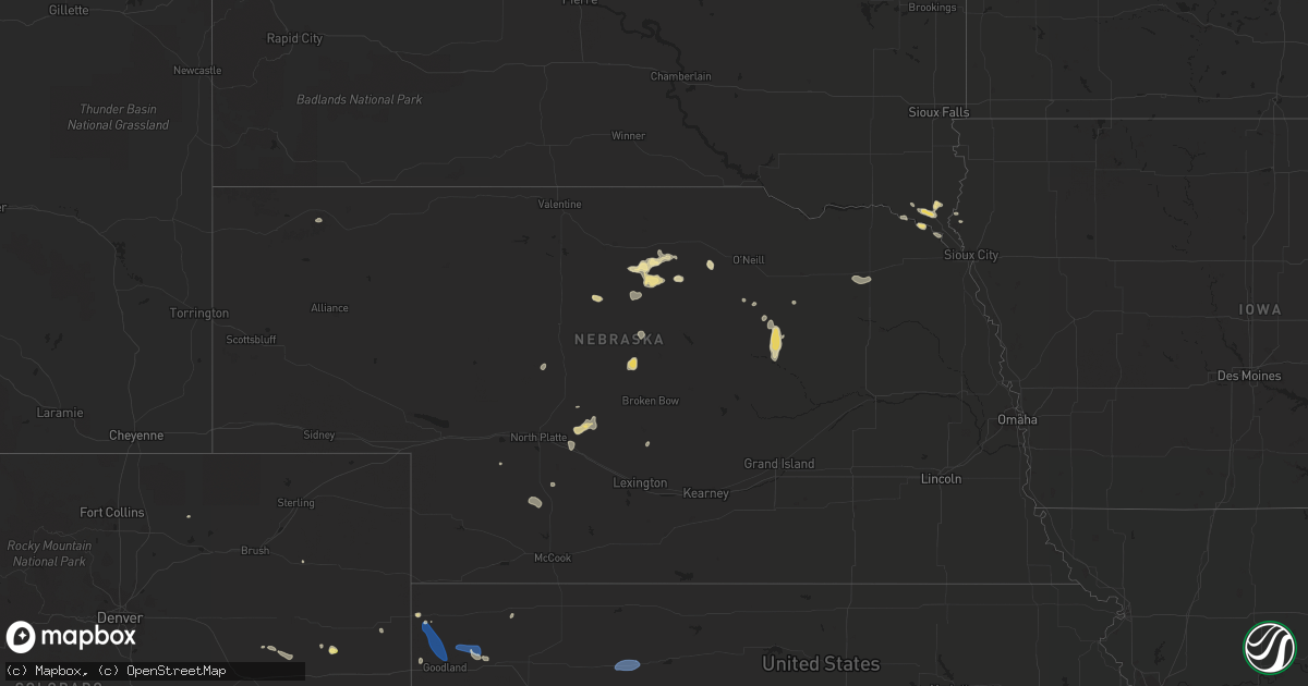
Hail Map in Nebraska on August 31, 2022
Get this storm
August 31 map
$229
one time, instant access
Download today. No call, no setup
Keep the $229
Bought the map and want the full workflow? Apply the entire $229 to a subscription within 7 days. None of it is wasted.
Every map, not just this one
This buys you this map. Subscription and you get every map we run, in the markets you choose from a few cities to whole states to nationwide. Plus real-time alerts the moment a storm fires.
Contact data
Name, contact info, occupancy, even credit band for addresses in the footprint. You go from where it hit to who to call.
Become the source they trust
Unlimited branding weather history reports on demand. You already have the documented answer ready for the property owner, and you are the one who showed up with it.
Property data and RoofTrace estimates
Pull up any address you have got, its value and the exact code rules for that jurisdiction, straight from One Click Code. Then RoofTrace estimates the squares, pitch, and roof value, priced the way you price.
Storm reports in Nebraska
Nebraska
| Date | Description |
|---|---|
| 08/31/20223:00 PM CDT | Report via twitter. |
| 08/31/20221:03 AM CDT | At 602 PM CDT, a severe thunderstorm was located 4 miles southwest of Coleridge, or 10 miles south of Hartington, moving east at 15 mph. HAZARD...60 mph wind gusts and quarter size hail. SOURCE...Radar indicated. IMPACT...Hail damage to vehicles is expected. Expect wind damage to roofs, siding, and trees. This severe thunderstorm will be near... Belden around 615 PM CDT. Coleridge around 620 PM CDT.Other locations in the path of this severe thunderstorm includeLaurel. |
| 08/31/202212:38 AM CDT | At 537 PM CDT, a severe thunderstorm was located over Osmond, or 23 miles north of Norfolk, moving southeast at 15 mph. HAZARD...60 mph wind gusts and quarter size hail. SOURCE...Radar indicated. IMPACT...Hail damage to vehicles is expected. Expect wind damage to roofs, siding, and trees. This severe thunderstorm will remain over mainly rural areas of northeastern Pierce and southeastern Knox Counties, including the following locations... McLean and The Highway 81 And 20 Junction. |
| 08/30/20227:15 PM CDT | Winds from back side of departing thunderstorms. |
All States Impacted by Hail Map on August 31, 2022
Cities Impacted by Hail Map on August 31, 2022
- Atwood, KS
- Ewing, NE
- Bartlett, NE
- Arriba, CO
- Genoa, CO
- Newcastle, NE
- Clearwater, NE
- Westfield, IA
- Briggsdale, CO
- Hammond, NY
- Heuvelton, NY
- Anselmo, NE
- Idalia, CO
- Arnold, NE
- Brady, NE
- Tryon, NE
- North Fort Myers, FL
- Punta Gorda, FL
- Vermillion, SD
- Burbank, SD
- Elk Point, SD
- Elgin, NE
- Spalding, NE
- Bassett, NE
- Kanorado, KS
- Seibert, CO
- Wheatland, WY
- Oakley, KS
- Jacksonville, FL
- Brewster, KS
- Edson, KS
- Karval, CO
- Vona, CO
- Saint Francis, KS
- Oconto, NE
- Eddyville, NE
- Wallace, NE
- Monticello, FL
- Brewster, NE
- Atkinson, NE
- Maxwell, NE
- Lake Park, GA
- Valdosta, GA
- Statenville, GA
- Colby, KS
- Johnstown, NE
- Pinetta, FL
- Montgomery, TX
- Gothenburg, NE
- Calhan, CO
- Peyton, CO
- Sanford, FL
- Mangum, OK
- Chadron, NE
- Ponca, NE
- Hayes Center, NE
- Maywood, NE
- Winter Springs, FL
- Casselberry, FL
- Akron, IA
- Nashville, GA
- Beulah, CO
- Long Pine, NE
- Fargo, GA
- New Smyrna Beach, FL
- Deland, FL
- Woodbine, GA
- Wellfleet, NE
- Chambers, NE
- Fort Myers, FL
- Wallace, KS
- Thedford, NE
- Wynot, NE
- Ainsworth, NE
- Rosanky, TX
- Waelder, TX
- Dale, TX
- Newport, NE
- Flagler, CO
- Colorado Springs, CO
- Ponte Vedra Beach, FL
- Akron, CO
- Osmond, NE
- Mclean, NE
- Pierce, NE
- Randolph, NE
- Folkston, GA
- Goodland, KS
- Bogue, KS
- Hill City, KS
- Penokee, KS


